Wayland Rural District

Last updated
Position within Norfolk, 1894 Wayland RD 1894.png
Position within Norfolk, 1894

Boundaries in 1894. 1902 extension in yellow
Position within Norfolk, 1935 Wayland RD 1935.png
Position within Norfolk, 1935

Boundaries in 1935

Wayland Rural District was a rural district in Norfolk, England from 1894 to 1974. [1]

Contents

It was formed under the Local Government Act 1894 based on the Wayland rural sanitary district, taking its name from the ancient Wayland hundred. It lay in the central southern part of the county.

In 1902 it took in the northern part of the disbanded Guiltcross Rural District, [2] and in 1935 the eastern section of the disbanded Thetford Rural District (much of which had also been transferred from Guiltcross RD).

In 1974, the district was abolished under the Local Government Act 1972, and became part of the Breckland district.

Statistics

YearArea (ha)
[3]
Population
[4]
Density
(pop/ha)
191127,83214,4250.52
192113,1210.47
193113,1500.47
195143,25420,6430.48
196119,4130.45

Parishes

ParishFromToNotes
Attleborough
Banham 1902Formerly Guiltcross RD
Besthorpe
Blo' Norton 1935Formerly Thetford RD (ex Guiltcross RD)
Breckles 1935Added to Stow Bedon
Brettenham 1935Formerly Thetford RD
Bridgham 1935Formerly Thetford RD (ex Guiltcross RD)
Carbrooke
Caston
Croxton 1935Formerly Thetford RD
Garboldisham 1935Formerly Thetford RD (ex Guiltcross RD)
Great Ellingham
Griston
Hargham 1935Added to Quidenham
East Harling Merger of East Harling and West Harling (from Thetford RD, ex Guiltcross RD)
Great Hockham
Illington 1935Added to Wretham
Kenninghall 1902Formerly Guiltcross RD
Kilverstone 1935Formerly Thetford RD
Larling 1935Added to Roudham
Little Ellingham
Merton
New Buckenham 1902Formerly Guiltcross RD
North Lopham 1935Formerly Thetford RD (ex Guiltcross RD)
Old Buckenham 1902Formerly Guiltcross RD
Ovington
Quidenham 1902Formerly Guiltcross RD
Riddlesworth 1935Formerly Thetford RD (ex Guiltcross RD)
Rocklands 1935Merger of next 2 parishes
Rockland All Saints and St Andrew 1935
Rockland St Peter 1935
Roudham
Scoulton
Shropham
Snetterton
South Lopham 1935Formerly Thetford RD (ex Guiltcross RD)
Stow Bedon
Thompson
Tottington
Watton
Wilby 19021935Formerly Guiltcross RD. Added to Quidenham
Wretham 1935Formerly Thetford RD

Related Research Articles

<span class="mw-page-title-main">Clare Rural District</span>

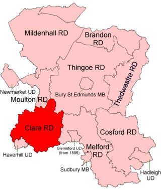
Clare Rural District was a rural district in the county of West Suffolk, England. It was created in 1894, comprising those parishes in the Risbridge rural sanitary district which were in Suffolk.

<span class="mw-page-title-main">Thingoe Rural District</span> Former rural district in West Suffolk, England

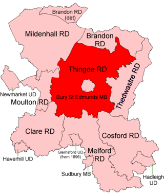
Thingoe Rural District was a rural district in the county of West Suffolk, England between 1894 and 1974. It was named after the ancient Hundred of Thingoe and administered from Bury St Edmunds, which it surrounded.

<span class="mw-page-title-main">Deben Rural District</span> Rural district in East Suffolk, England

Deben Rural District was a rural district in the county of East Suffolk, England. It was created in 1934 by the merger of parts of the disbanded Bosmere and Claydon Rural District, the disbanded Plomesgate Rural District and the disbanded Woodbridge Rural District, under a County Review Order. It was named after the River Deben and administered from Woodbridge.

<span class="mw-page-title-main">Walsingham Rural District</span>

Walsingham Rural District was a rural district in the county of Norfolk, England. It was created in 1894. On 1 April 1935 it was enlarged by the addition of the parishes of Hindolveston, Thurning, Wood Norton and Briston. On 1 April 1974 it was abolished under the Local Government Act 1972, and has since formed part of the District of North Norfolk.

<span class="mw-page-title-main">Downham Rural District</span>

Downham Rural District was a rural district in Norfolk, England from 1894 to 1974.

<span class="mw-page-title-main">Marshland Rural District</span>

Marshland Rural District was a rural district in Norfolk, England from 1894 to 1974.

<span class="mw-page-title-main">Swaffham Rural District</span>

Swaffham Rural District was a rural district in Norfolk, England from 1894 to 1974.

<span class="mw-page-title-main">Thetford Rural District</span>

Thetford Rural District was a rural district in Norfolk, England from 1894 to 1935.

<span class="mw-page-title-main">Depwade Rural District</span>

Depwade Rural District was a rural district in Norfolk, England from 1894 to 1974.

<span class="mw-page-title-main">Erpingham Rural District</span>

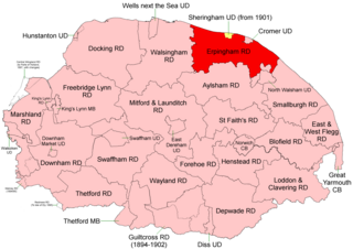
Erpingham Rural District was a rural district in Norfolk, England from 1894 to 1974.

<span class="mw-page-title-main">Loddon and Clavering Rural District</span>

Loddon and Clavering Rural District was a rural district in Norfolk, England from 1894 to 1935., continuing, with very slight boundary changes, as Loddon Rural District until 1974.

<span class="mw-page-title-main">St Faith's and Aylsham Rural District</span> Rural districts in Norfolk, England

St Faith's and Aylsham Rural Districts were adjacent rural districts in Norfolk, England from 1894 to 1935.

<span class="mw-page-title-main">Blofield and Flegg Rural District</span>

Blofield and East and West Flegg Rural Districts were adjacent rural districts in Norfolk, England from 1894 to 1935.

<span class="mw-page-title-main">Forehoe and Henstead Rural District</span>

Forehoe and Henstead Rural Districts were adjacent rural districts in Norfolk, England from 1894 to 1935.

<span class="mw-page-title-main">Guiltcross Rural District</span>

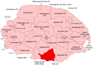
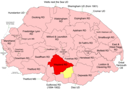
Guiltcross Rural District was a rural district in Norfolk, England from 1894 to 1902.

<span class="mw-page-title-main">Blything Rural District</span>

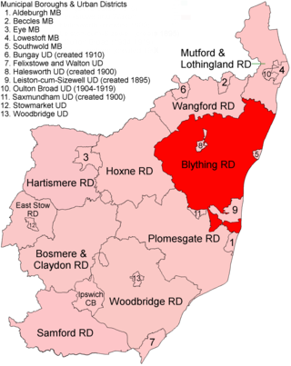
Blything Rural District was a rural district within the administrative county of East Suffolk between 1894 and 1934.

<span class="mw-page-title-main">Bosmere and Claydon Rural District</span>

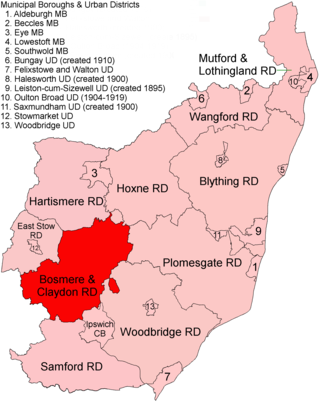
Bosmere and Claydon Rural District was a rural district within the administrative county of East Suffolk between 1894 and 1934. It was created out of the earlier Bosmere and Claydon rural sanitary district. It was named after the historic hundred of Bosmere and Claydon, although the rural district covered a significantly larger area than the hundred.

<span class="mw-page-title-main">Mutford and Lothingland Rural District</span> Former rural district in West Suffolk, England

Mutford and Lothingland Rural District was a rural district within the administrative county of East Suffolk between 1894 and 1934. It was created out of the earlier Mutford and Lothingland rural sanitary district. It was named after the historic hundred of Mutford and Lothingland, whose boundaries it closely matched.

<span class="mw-page-title-main">Plomesgate Rural District</span> Former rural district in West Suffolk, England

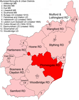
Plomesgate Rural District was a rural district within the administrative county of East Suffolk between 1894 and 1934.

<span class="mw-page-title-main">Wainford Rural District</span> Former rural district in East Suffolk, England

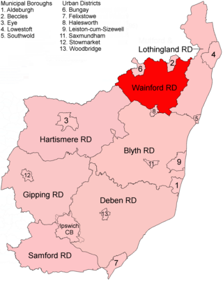
Wainford Rural District was a rural district in East Suffolk, England, between 1934 and 1974. It was created by a merger of the disbanded Wangford Rural District and parts of Blything Rural District, and contained the group of small villages collectively known as The Saints. The name Wainford is linked to that of Wangford, a historic hundred of Suffolk.

References

  1. "Wayland RD through time: Census tables with data for the Local Government District". A Vision of Britain through Time. GB Historical GIS / University of Portsmouth. Retrieved 29 June 2017.
  2. "Kenninghall CP/AP through time: Census tables with data for the Parish-level Unit". A Vision of Britain through Time. GB Historical GIS / University of Portsmouth. This change is not reported on the District level pages, but is apparent from parish commencement dates. Retrieved 29 June 2017.
  3. "Wayland RD through time: Population Statistics: Area (acres)". A Vision of Britain through Time. GB Historical GIS / University of Portsmouth. Retrieved 29 June 2017.
  4. "Wayland RD through time: Population Statistics: Total Population". A Vision of Britain through Time. GB Historical GIS / University of Portsmouth. Retrieved 29 June 2017.

52°32′N0°53′E / 52.54°N 0.88°E / 52.54; 0.88