Guiltcross Rural District

Last updated

Boundaries in 1894. Guiltcross RD 1894.png
Boundaries in 1894.

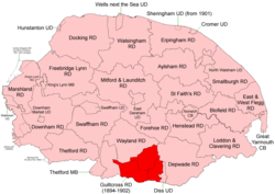
Guiltcross Rural District was a rural district in Norfolk, England from 1894 to 1902. [1]

It was formed under the Local Government Act 1894 based on the Guiltcross rural sanitary district. It lay in the southern part of the county between Thetford and Diss and took its name from the ancient Guiltcross hundred.

In 1902, Guiltcross RD was abolished and its territory divided between Thetford, [2] Wayland [3] and Depwade [4] RDs.

Parishes & Statistics

Population figures from 1901 census via Vision of Britain.

ParishArea (ha)PopulationNotes
Banham 1,616987To Wayland RD
Blo' Norton 462236To Thetford RD
Bressingham 980482To Depwade RD
Bridgham 1,106255To Thetford RD
East Harling 1,0571,031To Thetford RD
Fersfield 565219To Depwade RD
Garboldisham 1,116559To Thetford RD
Gasthorpe 35271To Thetford RD
Kenninghall 1,485976To Wayland RD
New Buckenham 146516To Wayland RD
North Lopham 817600To Thetford RD
Old Buckenham 2,0331,005To Wayland RD
Quidenham 718198To Wayland RD
Riddlesworth 47275To Thetford RD
Roydon 462667To Depwade RD
Shelfanger 698307To Depwade RD
South Lopham 791449To Thetford RD
West Harling 1,261101To Thetford RD
Wilby 57595To Wayland RD
Winfarthing 1,081461To Depwade RD
Total17,7939,290Density 0.52 / ha

References

  1. "Guiltcross RD through time: Census tables with data for the Local Government District". A Vision of Britain through Time. GB Historical GIS / University of Portsmouth. Retrieved 2 July 2017.
  2. "Thetford RD through time: Census tables with data for the Local Government District". A Vision of Britain through Time. GB Historical GIS / University of Portsmouth. The change is only apparent as parishes listed "from 1902". Retrieved 2 July 2017.
  3. "Wayland RD through time: Census tables with data for the Local Government District". A Vision of Britain through Time. GB Historical GIS / University of Portsmouth. Retrieved 2 July 2017.
  4. "Depwade RD through time: Census tables with data for the Local Government District". A Vision of Britain through Time. GB Historical GIS / University of Portsmouth. Retrieved 2 July 2017.

52°26′N0°59′E / 52.43°N 0.99°E / 52.43; 0.99