Croxton, Norfolk

Last updated

Croxton
Croxton-g4.jpg
Croxton All Saints
Norfolk UK location map.svg
Red pog.svg
Croxton
Location within Norfolk
Area18.96 km2 (7.32 sq mi)
Population445 (2011) [1]
  Density 23/km2 (60/sq mi)
OS grid reference TL876865
  London 74 miles
Civil parish
  • Croxton
District
Shire county
Region
Country England
Sovereign state United Kingdom
Post town THETFORD
Postcode district IP24
Dialling code 01842
Police Norfolk
Fire Norfolk
Ambulance East of England
UK Parliament
List of places
UK
England
Norfolk
52°26′42″N0°45′36″E / 52.4450°N 0.7600°E / 52.4450; 0.7600

Croxton is a village and civil parish in the English county of Norfolk, within the district of Breckland. Croxton is located 2.2 miles north of Thetford and 26 miles south-east of Norwich.

Contents

History

Croxton's name is of mixed Anglo-Saxon and Viking origin deriving from an amalgamation of the Old English and Old Norse for 'Krokr's' farmstead or settlement. [2]

In the Domesday Book, Croxton is recorded as a settlement of 21 households in the hundred of Grimshoe. In 1086, the village was part of the estate of King William. [3]

Geography

According to the 2011 Census, Croxton has 445 residents living in 194 households. [4]

Croxton falls within the constituency of South West Norfolk in the Parliament of the United Kingdom.

All Saints' Church

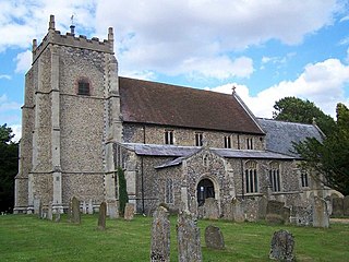
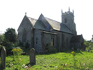
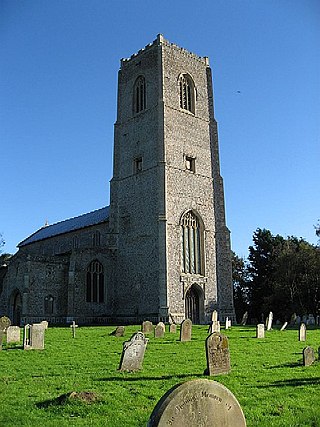
Croxton's parish church is one of the 124 remaining Anglo-Saxon round-tower churches in Norfolk. The church was significantly remodelled in the 19th century and features a rare example of a Continental church spire. [5]

War memorial

All Saints' Church holds an elaborate wooden carved memorial to the fallen from the First World War, listing the following names:

The memorial also features an engraving and separate memorial to Second-Lieutenant R. G. T. Meade (1895-1917) of the XIV King's Hussars who was killed fighting at the Battle of Ramadi. Meade is buried in Grave V.D.4 of the Baghdad North Gate War Cemetery in Iraq. [7]

Notes

  1. Office for National Statistics. (2011). Retrieved December 22, 2022. https://www.nomisweb.co.uk/reports/localarea?compare=E04006106
  2. "Key to English Place-names". kepn.nottingham.ac.uk. Retrieved 7 March 2024.
  3. "Croxton | Domesday Book". opendomesday.org. Retrieved 7 March 2024.
  4. "Custom report - Nomis - Official Census and Labour Market Statistics". www.nomisweb.co.uk. Retrieved 7 March 2024.
  5. "Norfolk Churches". www.norfolkchurches.co.uk. Retrieved 7 March 2024.
  6. "Lt R G T Meade and Men of Croxton WW1". www.warmemorialsonline.org.uk. Retrieved 7 March 2024.
  7. Commonwealth War Graves Commission. (2022). Retrieved December 22, 2022. https://www.cwgc.org/find-records/find-war-dead/casualty-details/7531731/richard-gilbert-trevor-meade/

Related Research Articles

<span class="mw-page-title-main">Dilham</span> Human settlement in England

Dilham is a village and civil parish in the English county of Norfolk. The village is located 4.3 miles south-east of North Walsham and 12 miles north-east of Norwich, and is situated on the River Ant.

<span class="mw-page-title-main">Denver, Norfolk</span> Human settlement in England

Denver is a village and civil parish in the English county of Norfolk. The village is situated on the River Great Ouse, approximately 1 mile (1.6 km) south of the small town of Downham Market, 14 miles (23 km) south of the larger town of King's Lynn, and 37 miles (60 km) west of the city of Norwich.

<span class="mw-page-title-main">Denton, Norfolk</span> Village in Norfolk, England

Denton is a village and civil parish in the English county of Norfolk. Denton is located 3.8 miles north-east of Harleston and 13 miles south of Norwich.

<span class="mw-page-title-main">Dunton, Norfolk</span> Village in Norfolk, England

Dunton is a village and civil parish in the North Norfolk district, in the county of Norfolk, England. It is located about 5 kilometres (3.1 mi) west of Fakenham and 41 kilometres (25 mi) north-west of Norwich.

<span class="mw-page-title-main">Carleton Rode</span> Village and civil parish in Norfolk, England

Carleton Rode is a village and civil parish in Norfolk, England. It is situated approximately five miles south-east of Attleborough. In the 2011 Census, Carleton Rode was recorded as having a population of 785 people in 324 households.

<span class="mw-page-title-main">Castle Rising</span> Village and civil parish in Norfolk, England

Castle Rising is a village and civil parish in the English county of Norfolk. The village is situated some 8 kilometres (5 mi) north-east of the town of King's Lynn and 60 kilometres (37 mi) west of the city of Norwich. The River Babingley skirts the north of the village separating Castle Rising from the site of the lost village of Babingley.

<span class="mw-page-title-main">Clenchwarton</span> Human settlement in England

Clenchwarton is a village, civil parish and electoral ward in the English county of Norfolk. It is located about 1+14 miles (2 km) west of the River Great Ouse, about 2+14 miles (4 km) from the town of King's Lynn on the east side of the river.

<span class="mw-page-title-main">Congham</span> Village in Norfolk, England

Congham is a village and civil parish in the English county of Norfolk. It is situated some 6 miles (10 km) east of the town of King's Lynn and 34 miles (55 km) west of the city of Norwich.

<span class="mw-page-title-main">Cockley Cley</span> Village and civil parish in England

Cockley Cley is a village and civil parish in the English county of Norfolk. The village covers an area of 17.94 km2 (6.93 sq mi) and falls within the district of Breckland.

<span class="mw-page-title-main">Colney</span> Village in Norfolk, England

Colney is a village in the western outskirts of Norwich in the English county of Norfolk.

<span class="mw-page-title-main">Catfield</span> Village in Norfolk, England

Catfield is a village and civil parish in the English county of Norfolk. The village is 19.7 miles (31.7 km) south-east of Cromer, 17.3 miles (27.8 km) north-east of Norwich and 136 miles (219 km) north-east of London. The village lies 2.7 miles (4.3 km) south-south-east of the nearby town of Stalham.

<span class="mw-page-title-main">Corpusty</span> Village in Norfolk, England

Corpusty is a village and former civil parish, now in the parish of Corpusty and Saxthorpe, in the North Norfolk district of Norfolk, England. It is located on the River Bure, about 16 mi (26 km) from Norwich and 6 mi (9.7 km) from Holt. In the 2011 Census, Corpusty had a population of 2,322 residents living in 1,193 households.

<span class="mw-page-title-main">Caston</span> Village and civil parish in Norfolk, England

Caston is a village and civil parish in the English county of Norfolk.

<span class="mw-page-title-main">Earsham</span> Human settlement in England

Earsham is a village and civil parish in the English county of Norfolk. Earsham is located 1.1 miles (1.8 km) west of Bungay and 13 miles (21 km) south-east of Norwich. The village is located close to the border between Norfolk and Suffolk, and the River Waveney.

<span class="mw-page-title-main">Deopham</span> Village in Norfolk, England

Deopham is a village and civil parish in the English county of Norfolk. Deopham is located 3.9 miles west of Wymondham and 12 miles south-west of Norwich.

<span class="mw-page-title-main">East Rudham</span> Human settlement in England

East Rudham is a village and civil parish in the English county of Norfolk. The village is located 14 miles (23 km) north-east of King's Lynn and 28 miles (45 km) north-west of Norwich.

<span class="mw-page-title-main">Elsing</span> Village in Norfolk, England

Elsing is a village and civil parish in the English county of Norfolk. The village is located 4.2 miles (6.8 km) north-east of Dereham and 12 miles (19 km) north-west of Norwich, close to the River Wensum.

<span class="mw-page-title-main">Drayton, Norfolk</span> Human settlement in England

Drayton, Norfolk, is a suburban village in the English county of Norfolk. The village is located in the district of Broadland, 4.3 miles (6.9 km) north west of Norwich, on the A1067 road between Hellesdon and Taverham. Today, Drayton is largely dominated by the Thorpe Marriott housing estate built in the late Twentieth Century.
<span class="mw-page-title-main">Carbrooke</span> Village in Norfolk, England

Carbrooke is a village and civil parish in the Breckland district of Norfolk, England. It is 3 miles (4.8 km) from the centre of Watton and 17 miles (27 km) from Thetford. In the 2011 Census, Carbrooke had a population of 2,073 people in 835 households.

<span class="mw-page-title-main">Cranworth</span> Village in Norfolk, in England

Cranworth is a village and civil parish in the Breckland district of the English county of Norfolk.