Borough of Great Yarmouth

Last updated

Borough of Great Yarmouth
-2020-08-17 Minster Church of St Nicholas, Great Yarmouth, Norfolk.jpg
Great Yarmouth UK locator map.svg
Great Yarmouth shown within Norfolk
Sovereign state United Kingdom
Constituent country England
Region East of England
Non-metropolitan county Norfolk
Status Non-metropolitan district
Admin HQ Great Yarmouth
Incorporated1 April 1974
Government
  TypeNon-metropolitan district council
  BodyGreat Yarmouth Borough Council
   MPs Sir Brandon Lewis
Area
  Total67.2 sq mi (174.0 km2)
  Rank154th (of 296)
Population
 (2021)
  Total100,146
  Rank242nd (of 296)
  Density1,500/sq mi (580/km2)
Ethnicity (2021)
[1]
   Ethnic groups
List
Religion (2021)
[1]
   Religion
List
Time zone UTC0 (GMT)
  Summer (DST) UTC+1 (BST)
OS grid reference TG5271507684

The Borough of Great Yarmouth is a local government district with borough status in Norfolk, England. It is named after its main town, Great Yarmouth, and also contains the town of Gorleston-on-Sea [2] [3] and a number of villages and rural areas, including part of The Broads. Other notable settlements include Caister-on-Sea, Hemsby, Hopton-on-Sea and Winterton-on-Sea.

Contents

The borough is on the east coast of Norfolk, facing the North Sea. It borders North Norfolk to the north, Broadland to the west, South Norfolk to the south-west, and East Suffolk to the south.

History

The town of Great Yarmouth was an ancient borough, having been granted a charter in 1208. The borough was enlarged in 1668 to take in the Southtown area (also known as Little Yarmouth) on the south side of the River Yare in the parish of Gorleston. [4] In 1703 the borough was given the right to appoint a mayor. The borough was reformed to become a municipal borough in 1836, when it was also enlarged to include the rest of the parish of Gorleston. [5] [6] When elected county councils were created in 1889, Great Yarmouth was considered large enough to provide its own county-level services and so it became a county borough, independent from the new Norfolk County Council. [7]

The modern district was formed on 1 April 1974 under the Local Government Act 1972, covering the whole area of the former county borough and parts of another two districts, which were all abolished at the same time: [8]

The Lothingland parishes had been in East Suffolk prior to the 1974 reforms; their inclusion in the Great Yarmouth district was brought about as an amendment to the draft legislation at committee stage proposed by Anthony Fell, Member of Parliament for the Great Yarmouth constituency. [9]

The new district was named Great Yarmouth after its main settlement. [10] The new district was granted borough status from its creation, allowing the chair of the council to take the title of mayor, continuing Great Yarmouth's series of mayors dating back to 1703. [11]

Governance

Great Yarmouth Borough Council
Great Yarmouth Borough Council logo.svg
Type
Type
Leadership
Penny Carpenter,
Conservative
since 18 May 2023 [12]
Carl Smith,
Conservative
since 16 May 2019
Sheila Oxtoby
since November 2015 [13]
Structure
Seats39 councillors
Political groups
Administration (19)
  Conservative (19)
Other parties (20)
  Labour (18)
  Independent (2)
Elections
Last election
4 May 2023
Next election
6 May 2027
Meeting place
Great Yarmouth Town Hall.jpg
Town Hall, Hall Plain, Great Yarmouth, NR30 2QF
Website
www.great-yarmouth.gov.uk

Great Yarmouth Borough Council provides district-level services. County-level services are provided by Norfolk County Council. Parts of the borough are also covered by civil parishes, which form a third tier of local government. [14] [15]

In the parts of the district within The Broads, town planning is the responsibility of the Broads Authority. The borough council appoints one of its councillors to sit on that authority. [16]

Political control

The council has been under no overall control since the 2023 election, being run by a Conservative minority administration. [17]

The first election to the borough council as reformed under the Local Government Act 1972 was held in 1973, initially operating as a shadow authority alongside the outgoing authorities until the new arrangements came into effect on 1 April 1974. Political control of the council since 1974 has been as follows: [18] [19]

Party in controlYears
Conservative 1974–1980
No overall control 1980–1983
Conservative 1983–1986
No overall control 1986–1990
Labour 1990–2000
Conservative 2000–2012
Labour 2012–2014
No overall control 2014–2017
Conservative 2017–2023
No overall control 2023–present

Leadership

The role of mayor is largely ceremonial in Great Yarmouth. Political leadership is instead provided by the leader of the council. The leaders since 1999 have been: [20]

CouncillorPartyFromTo
Barry Coleman [21] Conservative 19992011
Steve Ames Conservative 20116 May 2012
Trevor Wainwright [22] Labour May 201219 May 2015
Graham Plant Conservative 19 May 201516 May 2019
Carl Smith Conservative 16 May 2019

Composition

Following the 2023 election the composition of the council was: [23]

PartyCouncillors
Conservative 19
Labour 18
Independent 2
Total39

The next election is due in 2027.

Elections

Since the last boundary changes in 2004 the council has comprised 39 councillors representing 17 wards, with each ward election one, two or three councillors. Elections are held every four years. [24]

In the 2016 United Kingdom European Union membership referendum, 71.5% of Great Yarmouth voted to leave the European Union, the 5th highest such leave vote in the country.

UK Youth Parliament

Although the UK Youth Parliament is an apolitical organisation, the elections are run in a way similar to that of the Local Elections. The votes come from 11 to 18-year olds and are combined to make the decision of the next, 2-year Member of Youth Parliament. The elections are run at different times across the country with Great Yarmouth's typically being in early Spring and bi-annually. [25] [26] [27]

Gorleston-on-Sea, the second largest settlement in the borough Gorleston On Sea aerial image - Norfolk UK beach (14610803220).jpg
Gorleston-on-Sea, the second largest settlement in the borough

Premises

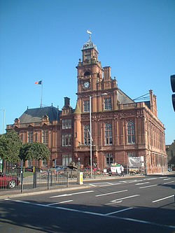
The council is based at Great Yarmouth Town Hall on Hall Plain, which was completed in 1882 for the old borough council. [28]

Geography

The borough comprises the urban area of Great Yarmouth itself, together with 21 surrounding parishes. At the time of the 2001 census, the borough had an area of 182 km², of which 26 km² was in the urban area and 156 km² in the surrounding parishes. The borough had a population of 90,810 in 39,380 households, with 47,288 people in 21,007 households living in the urban area, whilst 43,522 people in 18,373 households lived in the surrounding parishes. [29]

Places

Besides Great Yarmouth itself, other significant settlements in the borough include:

Great Yarmouth seafront from Scroby Sands. Great Yarmouth Sea Front from Scroby Sands - geograph.org.uk - 935269.jpg
Great Yarmouth seafront from Scroby Sands.

Parishes

The main part of Great Yarmouth itself, roughly corresponding to the pre-1974 borough (and so including Gorleston) is an unparished area. The remainder of the district comprises the following civil parishes:

† formerly part of Lothingland Rural District

Freedom of the Borough

The following people and military units have received the Freedom of the Borough of Great Yarmouth.

Individuals

[30] [31]

Military Units

[32]

See also

Related Research Articles

<span class="mw-page-title-main">Great Yarmouth</span> Seaside town in Norfolk, England

Great Yarmouth, often called Yarmouth, is a seaside town which gives its name to the wider Borough of Great Yarmouth in Norfolk, UK; it straddles the River Yare and is located 20 miles (32 km) east of Norwich. Its fishing industry, mainly for herring, shrank after the mid-20th century and has all but ended. North Sea oil from the 1960s supplied an oil-rig industry that services offshore natural gas rigs; more recently, offshore wind power and other renewable energy industries have ensued.

<span class="mw-page-title-main">St Olaves</span> Human settlement in England

St Olaves is a village in the English county of Norfolk. The village is situated on the River Waveney, 6 miles (10 km) south-west of the town of Great Yarmouth and the same distance north-west of the Suffolk town of Lowestoft. It is within The Broads national park.

The Norfolk Coast Path is a long-distance footpath in Norfolk, running 83 miles (133.5 km) from Hunstanton to Hopton-on-Sea. It was opened in 1986 and covers the North Norfolk Coast AONB.

<span class="mw-page-title-main">Gorleston-on-Sea</span> Town in England

Gorleston-on-Sea, historically and colloquially known as Gorleston, is a seaside town in the borough of Great Yarmouth in Norfolk, England. It lies to the south of Great Yarmouth, on the opposite side of the mouth of the River Yare. Historically in Suffolk, it was a port town at the time of the Domesday Book. It was incorporated into Great Yarmouth in 1836. Gorleston's port became a centre of fishing for herring along with salt pans used for the production of salt to preserve the fish. In Edwardian times the fishing industry rapidly declined and the town's role changed to that of a seaside resort.

<span class="mw-page-title-main">Hopton-on-Sea</span> Human settlement in England

Hopton-on-Sea is a village, civil parish and seaside resort on the coast of East Anglia in the county of Norfolk. The village is 4 miles (6.4 km) south of Great Yarmouth, 5 miles (8.0 km) north-west of Lowestoft.

<span class="mw-page-title-main">Lothingland Rural District</span> Former rural district in East Suffolk, England

Lothingland was a rural district in East Suffolk, England, named after the ancient half-hundred of Lothingland which was merged with Mutford half-hundred in 1763 to form Mutford and Lothingland.

<span class="mw-page-title-main">West Caister</span> Human settlement in England

West Caister is a village and civil parish in the English county of Norfolk. It is situated just inland from the coast, some 2 km (1.2 mi) from the seaside resort of Caister-on-Sea and 4 km (2.5 mi) north of the town of Great Yarmouth.

<span class="mw-page-title-main">Fritton, Great Yarmouth</span> Human settlement in England

Fritton is a village and former civil parish in county of Norfolk, England. The village is located 6 miles (9.7 km) south-west of Great Yarmouth and 16 miles (26 km) south-east of Norwich, along the A143 between Gorleston-on-Sea and Haverhill. In 1961 the parish had a population of 192.

<span class="mw-page-title-main">Fritton and St Olaves</span> Human settlement in England

Fritton and St Olaves is a civil parish in the English county of Norfolk. The parish comprises the villages of Fritton and St. Olaves, together with the surrounding rural area.

Hemsby is a village, seaside resort and civil parish in the county of Norfolk, England. It is situated some 8 mi (13 km) north of the town of Great Yarmouth. In the 2001 census Hemsby had a population of 2,973 in 1,221 households; by the 2011 census it had increased to 3,275. Hemsby borders the villages of Winterton-on-Sea and Scratby. For the purpose of local government, the parish is in the district of Great Yarmouth.

<span class="mw-page-title-main">First Eastern Counties</span> Bus operator in Norfolk and Suffolk, England

First Eastern Counties is a bus operator providing services in Norfolk and Suffolk in eastern England. It is a subsidiary of FirstGroup and has five depots in operating areas spread out across East Anglia. These areas are Norwich, Ipswich, Great Yarmouth, Lowestoft and King's Lynn.

Lowestoft was a parliamentary constituency centred on the town of Lowestoft in Suffolk. It returned one Member of Parliament (MP) to the House of Commons of the Parliament of the United Kingdom, elected by the first past the post voting system.

Great Yarmouth Borough Council elections are held every four years to elect Great Yarmouth Borough Council in Norfolk, England. Since the last boundary changes in 2004, 39 councillors have been elected from 17 wards. Prior to 2019 elections were held three years out of every four for a third of the council at a time.

<span class="mw-page-title-main">B1159 road</span> Road in England

The B1159 is a road in Norfolk, England, running for about 32 miles (51 km) between Cromer and Caister-on-Sea, parallel to and at a short distance from the northeastern coast of Norfolk.

<span class="mw-page-title-main">Lound, Suffolk</span> Human settlement in England

Lound is a village and civil parish in the north of the English county of Suffolk. It is 4.5 miles (7.2 km) north of Lowestoft, 5 miles (8.0 km) south of Great Yarmouth in the East Suffolk district. It is 2 miles (3.2 km) from the North Sea coast at Hopton-on-Sea and is on the border with the county of Norfolk.

Mutford and Lothingland was a hundred of Suffolk, with an area of 33,368 acres (135.04 km2). Lowestoft Ness, the most easterly point of Great Britain fell within its bounds.

<span class="mw-page-title-main">Mutford and Lothingland Rural District</span> Former rural district in West Suffolk, England

Mutford and Lothingland Rural District was a rural district within the administrative county of East Suffolk between 1894 and 1934. It was created out of the earlier Mutford and Lothingland rural sanitary district. It was named after the historic hundred of Mutford and Lothingland, whose boundaries it closely matched.

References

  1. Except a small detached part of the district containing the Shirehall, which went to Norwich.
  1. 1 2 UK Census (2021). "2021 Census Area Profile – Great Yarmouth Local Authority (E07000145)". Nomis. Office for National Statistics . Retrieved 5 January 2024.
  2. "8 facts about glorious Gorleston". Great British Life. 16 October 2019. Retrieved 7 December 2023.
  3. "A-Z of Norfolk nostalgia: A history of Gorleston in pictures". Great Yarmouth Mercury. 1 June 2017. Retrieved 7 December 2023.
  4. Suckling, Alfred (1846). The History and Antiquities of the County of Suffolk. Ipswich: W. S. Crowell. pp. 360–380.
  5. The Statutes of the United Kingdom of Great Britain and Ireland. p. 459. Retrieved 23 August 2023.
  6. The Statutes of the United Kingdom of Great Britain and Ireland. 1832. p. 353. Retrieved 23 August 2023.
  7. Local Government Act 1888
  8. "The English Non-metropolitan Districts (Definition) Order 1972", legislation.gov.uk , The National Archives, SI 1972/2039, retrieved 31 May 2023
  9. "Column 1107". Hansard. 6 July 1972. Retrieved 6 December 2023.
  10. "The English Non-metropolitan Districts (Names) Order 1973", legislation.gov.uk , The National Archives, SI 1973/551, retrieved 31 May 2023
  11. "District Councils and Boroughs". Parliamentary Debates (Hansard) . 28 March 1974. Retrieved 4 December 2021.
  12. "Council minutes, 18 May 2023". Great Yarmouth Borough Council. Retrieved 6 December 2023.
  13. Edwards, Anne (13 September 2016). "Yarmouth council announces new top team - all three from North Norfolk council". Eastern Daily Press. Retrieved 6 December 2023.
  14. "Local Government Act 1972", legislation.gov.uk , The National Archives, 1972 c. 70, retrieved 31 May 2023
  15. "Election Maps". Ordnance Survey. Retrieved 21 September 2023.
  16. "Who we are". Broads Authority. Retrieved 6 December 2023.
  17. Carroll, Anthony (18 May 2023). "Carl Smith re-elected as Great Yarmouth Borough Council leader". Great Yarmouth Mercury. Retrieved 6 December 2023.
  18. "Compositions calculator". The Elections Centre. Retrieved 14 May 2023.
  19. "Great Yarmouth". BBC News Online . 19 April 2008. Retrieved 19 March 2010.
  20. "Council minutes". Great Yarmouth Borough Council. Retrieved 24 June 2022.
  21. Owens, John (17 May 2011). "Former council leader made mayor of Great Yarmouth". Eastern Daily Press. Retrieved 24 June 2022.
  22. "Labour take overall control of Norwich City Council and win Great Yarmouth Borough Council". Eastern Daily Press. 4 May 2012. Retrieved 24 June 2022.
  23. "Local elections 2023: live council results for England". The Guardian.
  24. "The Borough of Great Yarmouth (Electoral Changes) Order 2002", legislation.gov.uk , The National Archives, SI 2002/3228, retrieved 6 December 2023
  25. "Members of Youth Parliament - Norfolk County Council". www.norfolk.gov.uk.
  26. "Your Norfolk -". yournorfolk.norfolkpublications.org.uk.
  27. Cope, Lauren (30 March 2018). "Norfolk's four new Members of Youth Parliament are announced". Eastern Daily Press.
  28. Historic England. "Town Hall (1246969)". National Heritage List for England . Retrieved 25 December 2020.
  29. Office for National Statistics & Norfolk County Council (2001). Census population and household counts for unparished urban areas and all parishes . Retrieved 2 December 2005.
  30. Weeds, James (10 April 2022). "Three-term mayor to be granted prestigious Honorary Freedom of the Borough". The Great Yarmouth Mercury. Retrieved 11 April 2022.
  31. Carroll, Anthony (15 April 2022). "Long-serving councillor granted freedom of the borough". The Great Yarmouth Mercury. Retrieved 16 April 2022.
  32. "Honorary Freedom of the Borough granted to local tourism stalwart and Great Yarmouth's twin town". 11 December 2019.
  33. Russell, Sam (28 September 2012). "Two groups honoured with freedom of Great Yarmouth borough". Eastern Daily Press.
  34. "Honorary Freedom of the Borough Ceremony. Pictures by James Bass". Great Yarmouth Mercury.
  35. Rogers, Lauren (10 June 2013). "Plans to give HMS Dauntless the Freedom of the Borough of Great Yarmouth".

52°36′27″N1°43′58″E / 52.60750°N 1.73278°E / 52.60750; 1.73278