The district borders the City of Colchester to the west and the Babergh District of Suffolk, across the estuary of the River Stour, to the north. To the east and south, it faces the North Sea, with the estuary of the River Colne to the south-west. The area is sometimes referred to as the Tendring Peninsula.
The modern local government district was formed in 1974. The name Tendring comes from the ancient Tendring Hundred which was named after the small village of Tendring.
History
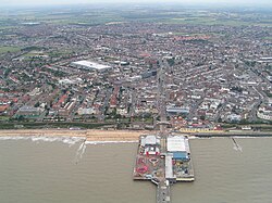
Harwich, an important port town in both the district and Essex
The district was formed on 1 April 1974 under the Local Government Act 1972, covering the whole area of five former districts, which were all abolished at the same time:[5]
The new district was named Tendring after the ancient Tendring Hundred, which was in turn named after the small village of Tendring at the centre of the area.[6]
The Tendring Poor Law Union, established in 1835, had covered the same area as the present district.[7]
During the English Civil War, the self-appointed Witchfinder General Matthew Hopkins carried out many trials throughout this and the surrounding area, especially in the town of Manningtree and village of Mistley on the River Stour.
The first election to the council was held in 1973, initially operating as a shadow authority alongside the outgoing authorities until the new arrangements came into effect on 1 April 1974. Political control of the council since 1974 has been as follows:[12][13]
Since the last boundary changes in 2019 there have been 48 councillors representing 32 wards, with each ward electing one, two or three councillors. Elections are held every four years.[22]
Following the 2023 election,[23] and subsequent by-elections and changes of allegiance up to June 2025, the composition of the council was:[24]
The Tendring First councillor and ten of the independent councillors form the "Tendring Independents" group. The other five independents sit as the "Independent Group". The council's administration is a coalition of the Tendring Independents, the Independent Group, Labour and the Liberal Democrats. The next full council election is due in 2027.[24]
Premises
The council has its main offices and meeting place at Clacton Town Hall on Station Road. The building had been built for the former Clacton Urban District Council in 1931.[25]
Geography
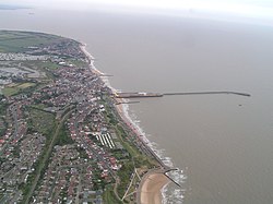
Walton-on-the-Naze, one of the many coastal settlements in the district
The highest part of the district is a low (115 feet; 35 metres) ridge running west to east only 2 miles (3km) south of the River Stour. The greater part of the district is undulating land sloping very gently to the south which is traversed by a number of streams.
In the extreme east of the district is an area formerly known as the Soken which was granted special privileges in Saxon times. It is remembered in the place names Kirby-le-Soken, Thorpe-le-Soken and Walton-le-Soken (an older name for Walton-on-the-Naze).
Demography
Jaywick, a shanty settlement on the coast near Clacton
Tendring district contains the most deprived part of England, in the Jaywick area. This area was ranked as the most deprived are in the government's indices of deprivation in 2010, 2015, 2019 and 2025.[26]
Media
In terms of television, the district is served by BBC East and ITV Anglia with television signals received from the Sudbury TV transmitter.[27]
There are 27 civil parishes in the district. The former Clacton Urban District is an unparished area.[28] The parish councils of Brightlingsea, Frinton and Walton, Harwich, and Manningtree take the style "town council".[29]
On a wreath of the colours an ancient ship Gules sail furled Proper flying flags and forked pennon of St. George and charged on the hull with three escallops Or pendent from the yardarm by chains a portcullis Or nailed and spiked Azure.
Escutcheon
Azure on a fess between two chevrons Argent a mural crown Gules all between two flaunches Argent each charged with two bars wavy Azure surmounted of a seaxe point upwards Proper hilt and pommel Or.
This page is based on this Wikipedia article Text is available under the CC BY-SA 4.0 license; additional terms may apply. Images, videos and audio are available under their respective licenses.