GSS codes are nine-character geocodes maintained by the United Kingdom's Office for National Statistics (ONS) to represent a wide range of geographical areas of the UK, for use in tabulating census and other statistical data. GSS refers to the Government Statistical Service of which ONS is part.
GSS codes replaced a previous system called ONS codes from January 2011. [1] [2] ONS codes were hierarchical whereas in GSS codes there is no relation between the code for a lower-tier area and the corresponding parent area.
GSS codes have a fixed length code of nine characters. The first three characters indicate the level of geography, and the six digits following define the individual unit. For example, the Royal Borough of Greenwich is coded as E09000011
, Middlesbrough is E06000002
, Cambridge E07000008
and Fenland E07000010
.
As of December 2022 [update] , the meanings of some common three character prefixes are as follows: [3] [4] [5]
England | Wales | Scotland | Northern Ireland | Other | Status | Entity |
---|---|---|---|---|---|---|
E00 | W00 | S00 | N00 | - | Current | Census Output Area (OA); Small Areas (N) |
E01 | W01 | S01 | – | - | Current | Lower layer Super Output Area (LSOA); Data Zone (S) |
E02 | W02 | S02 | – | - | Current | Middle layer Super Output Area (MSOA); Intermediate Zone (S) |
E04 | W04 | S35 | – | - | Current | Civil Parish (E/S); Community (W) |
E05 | W05 | S13 | N08 | - | Current | Ward or Electoral Division |
E06 | W06 | S12 | – | - | Current | Unitary Authority |
E07 | – | – | – | - | Current | Non-Metropolitan District (two-tier) |
E08 | – | – | – | - | Current | Metropolitan Borough |
E09 | – | – | – | - | Current | London Borough |
E10 | – | – | – | - | Current | County |
E11 | – | – | – | - | Current | Metropolitan County |
E12 | – | – | – | - | Current | English Region |
E13 | – | – | – | - | Current | Inner and Outer London |
E14 | W07 | S14 | N06 | - | Current | Westminster Parliamentary Constituency |
E15 | W08 | S15 | N07 | - | Current | European Electoral Region |
E16 | - | - | - | - | Archived | Primary Care Trusts |
E17 | - | - | - | - | Archived | Care Trusts |
E18 | - | - | - | L00 / M00 | Archived | Strategic Health Authorities |
E19 | - | - | - | - | Archived | Pan Strategic Health Authorities |
E20 | W12 | - | - | - | Current | Cancer Registries |
E21 | W13 | - | - | - | Archived | Cancer Networks |
E22 | W14 | - | - | - | Current | Community Safety Partnerships |
E23 | W15 | S23 | N23 | - | Current | Police Force Areas |
E24 | - | - | - | - | Archived | Local Learning and Skills Councils |
E25 | - | - | - | - | Current | Primary Urban Areas |
E26 | W18 | S21 | - | - | Current | National Parks |
E27 | - | - | - | - | Archived | New Deal for Communities |
E28 | W20 | - | - | - | Current | Registration Districts |
E29 | W21 | - | - | - | Current | Registration Sub-District |
E30 | W22 | S22 | N12 | K01 | Current | Travel to Work Areas |
E31 | W25 | S38 | N31 | - | Current | Fire and Rescue Authorities |
E32 | W09 | S16 | – | - | Current | London Assembly; Welsh Assembly; Scottish Parliament Constituency |
E33 | W35 | S34 | N19 | - | Current | Workplace Zones |
E34 | W37 | - | - | K05 | Archived | 2011 Built Up Areas |
E35 | W38 | - | - | K06 | Archived | 2011 Built Up Area Sub-Divisions |
E36 | W39 | - | - | - | Current | Census Merged Wards |
E37 | - | - | - | - | Current | Local Enterprise Partnerships |
E38 | - | - | - | - | Current | Clinical Commissioning Groups |
E39 | - | - | - | - | Archived | NHS England |
E40 | - | - | - | - | Current | NHS England Regions |
E41 | W40 | - | - | - | Current | Merged Local Authority Districts |
E42 | - | - | - | - | Current | Census Merged Counties |
E43 | - | - | - | - | Current | Non-Civil Parished Areas |
E45 | - | - | - | - | Current | Public Health England Centres |
E46 | - | - | - | - | Current | Public Health England Regions |
E47 | - | - | - | - | Current | Combined Authorities |
E48 | - | - | - | - | Current | Local Resilience Forums |
E49 | - | - | - | - | Current | Enterprise Zones |
E50 | - | - | - | - | Current | Waste Authorities |
E51 | - | - | - | - | Current | Development Corporations |
E52 | - | - | - | - | Current | LEP - overlapping part |
E53 | - | - | - | - | Current | LEP - non overlapping part |
E54 | - | - | - | - | Current | Integrated care boards (formerly Sustainability and Transformation Partnerships) |
E55 | - | - | - | - | Current | Strategic Clinical Networks |
E56 | - | - | - | - | Current | Cancer Alliances |
E57 | - | - | - | - | Archived | National Cancer Vanguards |
E58 | - | - | - | - | Current | County Electoral Divisions |
E59 | - | - | - | - | Current | Integrated Care Systems |
E60 | W43 | S44 | N13 | - | Current | Local Planning Authorities |
E61 | - | - | - | - | Current | Greater London Authority |
E63 | W45 | S45 | K08 | Current | 2022 Built Up Areas | |
E92 | W92 | S92 | N92 | L93 / M83 | Current | Country |
E92 | W92 | S92 | N92 | - | Current | Country |
- | - | - | - | J01 | Current | Major Towns and Cities |
- | - | - | - | J02 | Current | 1961 Census Parishes |
- | - | - | - | J03 | Current | 1961 Census Wards |
- | - | - | - | J04 | Current | 1961 Census Districts |
- | - | - | - | J05 | Current | 1961 Census Counties |
- | - | - | - | K02 | Current | United Kingdom |
- | - | - | - | K03 | Current | Great Britain |
- | - | - | - | K04 | Current | England and Wales |
- | - | - | - | L93 / M83 | Current | British Crown Dependencies |
- | - | - | - | M01 | Current | Primary Healthcare Directorate |
- | - | - | N09 | - | Current | Local Government Districts |
- | - | - | N10 | - | Current | District Election Areas |
- | - | - | N11 | - | Current | Settlement 2015 |
- | - | - | N24 | - | Current | Police Force Districts |
- | - | - | N32 | - | Current | Northern Ireland Fire and Rescue Service Areas |
- | - | - | N33 | - | Current | Northern Ireland Fire and Rescue Service Districts |
- | - | - | N34 | - | Current | City Regions |
- | - | S03 | - | - | Archived | Community Health Partnerships |
- | - | S04 | - | - | Current | Regeneration Outcome Agreement Areas - Scotland |
- | - | S05 | - | - | Current | Regeneration Outcome Areas - Community Planning Partnerships |
- | - | S06 | - | - | Current | Regeneration Outcome Areas - Local Areas |
- | - | S07 | - | - | Current | Regional Transport Partnerships |
- | - | S08 | - | - | Current | Health Board areas |
- | - | S09 | - | - | Current | Enterprise Regions |
- | - | S10 | - | - | Current | Urban Regeneration Companies |
- | - | S11 | - | - | Current | Strategic Development Plan Areas |
- | - | S12 | - | - | Current | Council Areas |
– | W10 | S17 | – | - | Current | Welsh Assembly; Scottish Parliament Electoral Region |
- | - | S19 | - | - | Current | Localities |
- | - | S20 | - | - | Current | Settlements |
- | - | S24 | - | - | Current | Highlands and Islands Enterprise |
- | - | S25 | - | - | Current | Community Justice Authorities |
- | - | S26 | - | - | Archived | Community Health Partnerships sub-areas |
- | - | S27 | - | - | Current | ISD Health Board of Treatment |
- | - | S28 | - | - | Current | Census Detailed Characteristics |
- | - | S29 | - | - | Current | Census Local Characteristics |
- | - | S30 | - | - | Current | Local Administrative Units 1 |
- | - | S31 | - | - | Current | Local Administrative Units 2 |
- | - | S32 | - | - | Current | Scottish Police Divisions |
- | - | S33 | - | - | Current | Broad Rental Market Areas |
- | - | S35 | - | - | Current | Civil Parish |
- | - | S36 | - | - | Current | Island Groups |
- | - | S37 | - | - | Current | Integration Authorities |
- | - | S39 | - | - | Current | Scottish Fire and Rescue Local Senior Officer Areas |
- | - | S40 | - | - | Current | Scottish Fire and Rescue Service Delivery Areas |
- | - | S41 | - | - | Current | Scottish Marine Regions |
- | - | S42 | - | - | Current | Scottish Local Resilience Partnerships |
- | - | S43 | - | - | Current | Scottish Regional Resilience Partnerships |
- | W03 | - | – | - | Current | Upper layer Super Output Area (USOA) |
- | W04 | - | – | - | Current | Communities |
- | W11 | - | – | - | Current | Local Health Boards |
- | W16 | - | – | - | Current | Department for Children, Education, Lifelong Learning and Skills |
- | W19 | - | – | - | Current | National Assembly Economic Regions |
- | W23 | - | – | - | Current | Spatial Plan Areas |
- | W24 | - | – | - | Current | Spatial Plan Sub-areas |
- | W26 | - | – | - | Current | Strategic Regeneration Areas |
- | W27 | - | – | - | Current | Strategic Regeneration Sub-areas |
- | W28 | - | – | - | Current | Transport Consortia Areas |
- | W29 | - | – | - | Current | Agricultural Regions |
- | W30 | - | – | - | Current | Agricultural Small Areas |
- | W31 | - | – | - | Current | Non-National Park Area |
- | W32 | - | – | - | Current | Non-Strategic Regeneration Area |
- | W33 | - | – | - | Current | Communities First Areas |
- | W34 | - | – | - | Current | Non-Communities First Areas |
- | W36 | - | – | - | Current | Footprint Regions for Public Service Collaboration |
- | W42 | - | – | - | Current | City Regions |
In 2019, the House of Commons Library proposed names instead of numeric codes for MSOAs to make them easier to use.[ citation needed ] In 2021 the library created names for MSOAs for use within the house. [6]
A full listing of GSS names and codes may be found by following the link to ONS Geography's Code History Database, below.
Information from the 2011 Census is published for a wide variety of geographical units. These areas include:
Super Output Areas (SOAs) are a set of geographical areas developed following the 2001 Census, initially to facilitate the calculation of the Indices of Deprivation 2004 and subsequently for a range of additional Neighbourhood Statistics (NeSS). The aim was to produce a set of areas of consistent size, whose boundaries would not change (unlike electoral wards), suitable for the publication of data such as the Indices of Deprivation. They are an aggregation of adjacent Output Areas with similar social characteristics. Lower Layer Super Output Areas (LSOAs) typically contain 4 to 6 OAs with a population of around 1,500. Middle Layer Super Output Areas (MSOAs) on average have a population of 7,200. [8] The hierarchy of Output Areas and the two tiers of Super Output Areas have become known as the Neighbourhood Statistics Geography.[ citation needed ]
MSOAs use the name of the local or unitary authority followed by three digits, for example "Tower Hamlets 022" which is E02000885
. [9] LSOAs use the name of the containing MSOA followed by a letter, for example "Tower Hamlets 022C" which is E01004304
. [10]
Some LSOAs and MSOAs were revised in alignment with the 2021 Census. [11]
The older ONS code was constructed top down:
12
for Cambridgeshire.12UB
for Cambridge district or 12UD
for Fenland.00AL
for Greenwich (London Borough) or 00EC
for Middlesbrough.12UBGA
for Petersfield Ward within Cambridge district.12UBGA0001
.12UD
for Fenland district, the parish of Tydd St. Giles was coded 12UD010
.Statistical geography is the study and practice of collecting, analysing and presenting data that has a geographic or areal dimension, such as census or demographics data. It uses techniques from spatial analysis, but also encompasses geographical activities such as the defining and naming of geographical regions for statistical purposes. For example, for the purposes of statistical geography, the Australian Bureau of Statistics uses the Australian Standard Geographical Classification, a hierarchical regionalisation that divides Australia up into states and territories, then statistical divisions, statistical subdivisions, statistical local areas, and finally census collection districts.
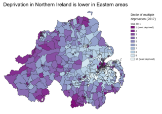
A deprivation index or poverty index is a data set to measure relative deprivation of small areas. Such indices are used in spatial epidemiology to identify socio-economic confounding.
A census of the population of the United Kingdom is taken every ten years. The 2011 census was held in all counties of the UK on 27 March 2011. It was the first UK census which could be completed online via the Internet. The Office for National Statistics (ONS) is responsible for the census in England and Wales, the General Register Office for Scotland (GROS) is responsible for the census in Scotland, and the Northern Ireland Statistics and Research Agency (NISRA) is responsible for the census in Northern Ireland.
Crooklands is a hamlet in Westmorland and Furness, Cumbria, England, 4.5 miles (7.2 km) south of Kendal on the A65 road and the Lancaster Canal. Historically part of Westmorland, it is in the parish of Preston Richard but adjacent to Preston Patrick to the south east, the boundary roughly following Peasey Beck. The adjacent showfield of the Westmorland County Agricultural Society is the venue of the annual Westmorland County Show, Country Fest and various other events.
The Unique Property Reference Number (UPRN) is a unique number for every addressable location—e.g., a building, a bus stop, a post box, a feature in the landscape, or a defibrillator—in Great Britain. Over 42 million locations have UPRNs, which can be found in Ordnance Survey's AddressBase databases.
The ONS Postcode Directory (ONSPD) relates both current and terminated postcodes in the United Kingdom to a range of current statutory administrative, electoral, health and other area geographies. It also links postcodes to pre-2002 health areas, 1991 Census enumeration districts for England and Wales, 2001 Census Output Areas (OA) and Super Output Areas (SOA) for England and Wales, 2001 Census OAs and SOAs for Northern Ireland and 2001 Census OAs and Data Zones (DZ) for Scotland. It helps support the production of area based statistics from postcoded data.
The Index of Place Names (IPN) in Great Britain is published by the Office for National Statistics.
Alexandra Ward is a ward in the central area of Ipswich, Suffolk, England. It returns three councillors to Ipswich Borough Council.
Gainsborough Ward is a ward in the South East Area of Ipswich, Suffolk, England. It returns three councillors to Ipswich Borough Council.
St John's Ward is a ward in the North East Area of Ipswich, Suffolk, England. It returns three councillors to Ipswich Borough Council.
Bixley Ward is a ward in the north east area of Ipswich, Suffolk, England. It returns three councillors to Ipswich Borough Council.
The South West Area, Ipswich is one of five administrative areas in Ipswich, through which Ipswich Borough Council divides its spending and enables feedback from local residents, businesses and community groups.
The Central Area, Ipswich is one of five administrative areas in Ipswich, through which Ipswich Borough Council divides its spending and enables feedback from local residents, businesses and community groups.
The North East Area, Ipswich is one of five administrative areas in Ipswich, through which Ipswich Borough Council divides its spending and enables feedback from local residents, businesses and community groups.
The North West Area, Ipswich is one of five administrative areas in Ipswich, through which Ipswich Borough Council divides its spending and enables feedback from local residents, businesses and community groups.
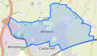
Whitton Ward is a ward in the North West Area of Ipswich, Suffolk, England. It returns three councillors to Ipswich Borough Council.
Sprites Ward is a ward in the South West Area of Ipswich, Suffolk, England. It returns three councillors to Ipswich Borough Council.
Stoke Park Ward is a ward in the South West Area of Ipswich, Suffolk, England. It returns three councillors to Ipswich Borough Council.
Westgate Ward is a ward in the central Area of Ipswich, Suffolk, England. It returns three councillors to Ipswich Borough Council.