Related Research Articles
In marketing, market segmentation is the process of dividing a broad consumer or business market, normally consisting of existing and potential customers, into sub-groups of consumers based on shared characteristics.

In digital image processing and computer vision, image segmentation is the process of partitioning a digital image into multiple image segments, also known as image regions or image objects. The goal of segmentation is to simplify and/or change the representation of an image into something that is more meaningful and easier to analyze. Image segmentation is typically used to locate objects and boundaries in images. More precisely, image segmentation is the process of assigning a label to every pixel in an image such that pixels with the same label share certain characteristics.

Cluster analysis or clustering is the task of grouping a set of objects in such a way that objects in the same group are more similar to each other than to those in other groups (clusters). It is a main task of exploratory data analysis, and a common technique for statistical data analysis, used in many fields, including pattern recognition, image analysis, information retrieval, bioinformatics, data compression, computer graphics and machine learning.
Mosaic is Experian's system for geodemographic classification of households. It applies the principles of geodemography to consumer household and individual data collated from a number of government and commercial sources. The statistical development of the system was led by professor Richard Webber in association with Experian in the 1980s, and it has been regularly refreshed and reclassified since then, each based on more recent data from national censuses and other sources. Since its initial development in the UK, the Mosaic brand name has also been used to market separate products which classify other national consumers including most of Western Europe, USA, selected Asian regions and Australia.
Geodemography is the study of people based on where they live; it links the sciences of demography, the study of human population dynamics, and geography, the study of the locational and spatial variation of both physical and human phenomena on Earth, along with sociology. It includes the application of geodemographic classifications for business, social research and public policy but has a parallel history in academic research seeking to understand the processes by which settlements evolve and neighborhoods are formed. Geodemographic systems estimate the most probable characteristics of people based on the pooled profile of all people living in a small area near a particular address.
Psychographics is defined as "market research or statistics classifying population groups according to psychological variables" The term psychographics is derived from the words “psychological” and “demographics” Two common approaches to psychographics include analysis of consumers' activities, interests, and opinions, and values and lifestyles (VALS).
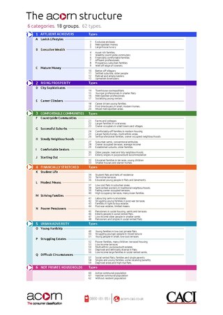
Acorn, developed by CACI Limited in London, is a segmentation tool which categorises the United Kingdom’s population into demographic types. It has been built by analysing social factors and behaviour. Acorn segments households, postcodes and neighbourhoods into six categories, 18 groups and 62 types.
The target audience is the intended audience or readership of a publication, advertisement, or other message catered specifically to the previously intended audience. In marketing and advertising, the target audience is a particular group of consumer within the predetermined target market, identified as the targets or recipients for a particular advertisement or message.
The following outline is provided as an overview of and topical guide to marketing:
Technographic segmentation for marketing management is a market research analysis tool used to identify and profile the characteristics and behaviors of consumers through the process of market segmentation. Traditionally market researchers focused on various demographic, psychographic, and lifestyle schemes to categorize and describe homogeneous clusters of consumers that comprise possible target markets.
Micromarketing was first referred to in the UK marketing press in November 1988 in respect of the application of geodemographics to consumer marketing. The subject of micromarketing was developed further in an article in February 1990, which emphasised understanding markets at the local level, and also the personalisation of messages to individual consumers in the context direct marketing. Micromarketing has come to refer to marketing strategies which are variously customised to either local markets, to different market segments, or to the individual customer.
A target market, also known as serviceable obtainable market (SOM), is a group of customers within a business's serviceable available market at which a business aims its marketing efforts and resources. A target market is a subset of the total market for a product or service.
Claritas PRIZM Premier is a set of geo-demographic segments for the United States, developed by Claritas Inc., which was owned under The Nielsen Company umbrella from 2009 to 2016.
Firmographics are sets of characteristics to segment prospect organizations.
In information science, profiling refers to the process of construction and application of user profiles generated by computerized data analysis.
In business intelligence, data classification is "the construction of some kind of a method for making judgments for a continuing sequence of cases, where each new case must be assigned to one of pre-defined classes."
Precision marketing is a marketing technique that suggests successful marketing is to retain, cross-sell, and upsell existing customers.
The fields of marketing and artificial intelligence converge in systems which assist in areas such as market forecasting, and automation of processes and decision making, along with increased efficiency of tasks which would usually be performed by humans. The science behind these systems can be explained through neural networks and expert systems, computer programs that process input and provide valuable output for marketers.
Psychographic segmentation has been used in marketing research as a form of market segmentation which divides consumers into sub-groups based on shared psychological characteristics, including subconscious or conscious beliefs, motivations, and priorities to explain and predict consumer behavior. Developed in the 1970s, it applies behavioral and social sciences to explore to understand consumers’ decision-making processes, consumer attitudes, values, personalities, lifestyles, and communication preferences. It complements demographic and socioeconomic segmentation, and enables marketers to target audiences with messaging to market brands, products or services. Some consider lifestyle segmentation to be interchangeable with psychographic segmentation, marketing experts argue that lifestyle relates specifically to overt behaviors while psychographics relate to consumers' cognitive style, which is based on their "patterns of thinking, feeling and perceiving".
Manifold Data Mining Inc. is a Canadian company specializing in consumer data products, analytics, and predictive modeling. As a data and analytical service provider in Canada, they have been providing businesses, charities, and governmental organizations with comprehensive data products since being founded in 2001. For each neighbourhood, they provide estimates of what products consumers buy, where and how often they shop, how much they spend, which media channels they use, their lifestyles, and their attitudes or psychographics.
References
- 1 2 Grekousis, George; Thomas, Hatzichristos (2012). "Comparison of two fuzzy algorithms in geodemographic segmentation analysis: The Fuzzy C-Means and Gustafson–Kessel methods". Applied Geography. 34: 125–136. doi:10.1016/j.apgeog.2011.11.004.
- ↑ "Using Intelligent Systems to infer ethnicity from names, Richard Webber, UCL 2006".
- ↑ "Onomastics for business: can discrimination help development? - Paris Innovation Review". www.paristechreview.com.
- ↑ "Consumer Lifestyle Clusters | Manifold Data Mining" . Retrieved 2020-11-12.
- ↑ Market segmentation system for Canada PSYTE HD Canada
- ↑ Experian. "Segmentation". www.segmentationportal.com.
- ↑ "Esri Data - Current Year Demographic & Business Data - Estimates & Projections". www.esri.com.
- Brimicombe, A. J. (2007). "A dual approach to cluster discovery in point event data sets". Computers, Environment and Urban Systems. 31: 4–18. doi:10.1016/j.compenvurbsys.2005.07.004.
- Feng, Z., Flowerdew, R., 1999. The use of fuzzy classification to improve geodemographic targeting. In B.Gittings (Ed.), Innovations in GIS 6 London:Taylor &Francis, (pp. 133 –144).
- Grekousis, G.; Hatzichristos, T. (2012). "Comparison of two fuzzy algorithms in geodemographic segmentation analysis: The Fuzzy C-Means and Gustafson–Kessel methods". Applied Geography. 34: 125–136. doi:10.1016/j.apgeog.2011.11.004.
- Spielman, S.E.; Thill, J.C. (2008). "Social area analysis, data mining and GIS". Computers, Environment and Urban Systems. 32 (2): 110–122. doi:10.1016/j.compenvurbsys.2007.11.004.