A geographic coordinate system (GCS) is a spherical or geodetic coordinate system for measuring and communicating positions directly on Earth as latitude and longitude. It is the simplest, oldest and most widely used of the various spatial reference systems that are in use, and forms the basis for most others. Although latitude and longitude form a coordinate tuple like a cartesian coordinate system, the geographic coordinate system is not cartesian because the measurements are angles and are not on a planar surface.
A projected coordinate system – also called a projected coordinate reference system, planar coordinate system, or grid reference system – is a type of spatial reference system that represents locations on Earth using Cartesian coordinates (x, y) on a planar surface created by a particular map projection. Each projected coordinate system, such as "Universal Transverse Mercator WGS 84 Zone 26N," is defined by a choice of map projection (with specific parameters), a choice of geodetic datum to bind the coordinate system to real locations on the earth, an origin point, and a choice of unit of measure. Hundreds of projected coordinate systems have been specified for various purposes in various regions.

The Ordnance Survey National Grid reference system (OSGB), also known as British National Grid (BNG), is a system of geographic grid references, distinct from latitude and longitude, whereby any location in Great Britain can be described in terms of its distance from the origin, which lies to the west of the Isles of Scilly.
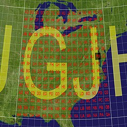
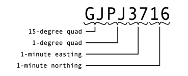
The Maidenhead Locator System is a geocode system used by amateur radio operators to succinctly describe their geographic coordinates, which replaced the deprecated QRA locator, which was limited to European contacts. Its purpose is to be concise, accurate, and robust in the face of interference and other adverse transmission conditions. The Maidenhead Locator System can describe locations anywhere in the world.
A geocode is a code that represents a geographic entity. It is a unique identifier of the entity, to distinguish it from others in a finite set of geographic entities. In general the geocode is a human-readable and short identifier.
The National Topographic System or NTS is the system used by Natural Resources Canada for providing general purpose topographic maps of the country. NTS maps are available in a variety of scales, the standard being 1:50,000 and 1:250,000 scales. The maps provide details on landforms and terrain, lakes and rivers, forested areas, administrative zones, populated areas, roads and railways, as well as other human-made features. These maps are currently used by all levels of government and industry for forest fire and flood control, depiction of crop areas, right-of-way, real estate planning, development of natural resources and highway planning. To add context, land area outside Canada is depicted on the 1:250,000 maps, but not on the 1:50,000 maps.
ISO 6709, Standard representation of geographic point location by coordinates, is the international standard for representation of latitude, longitude and altitude for geographic point locations.
The Irish grid reference system is a system of geographic grid references used for paper mapping in Ireland. Any location in Ireland can be described in terms of its distance from the origin, which lies off the southwest coast. The Irish grid partially overlaps the British grid, and uses a similar co-ordinate system but with a meridian more suited to its westerly location.
The Military Grid Reference System (MGRS) is the geocoordinate standard used by NATO militaries for locating points on Earth. The MGRS is derived from the Universal Transverse Mercator (UTM) grid system and the Universal Polar Stereographic (UPS) grid system, but uses a different labeling convention. The MGRS is used as geocode for the entire Earth.

Marsden square mapping or Marsden squares is a system that divides a world map with latitude-longitude gridlines between 80°N and 70°S latitudes into grid cells of 10° latitude by 10° longitude, each with a geocode, a unique numeric identifier. The method was devised by William Marsden, when first secretary of the British Admiralty, for collecting and combining geographically based information about the oceans.
Decimal degrees (DD) is a notation for expressing latitude and longitude geographic coordinates as decimal fractions of a degree. DD are used in many geographic information systems (GIS), web mapping applications such as OpenStreetMap, and GPS devices. Decimal degrees are an alternative to using sexagesimal degrees. As with latitude and longitude, the values are bounded by ±90° and ±180° respectively.
The Global Area Reference System (GARS) is a standardized geospatial reference system developed by the National Geospatial-Intelligence Agency (NGA) for use across the United States Department of Defense. Under the Chairman of the Joint Chiefs of Staff Instruction CJCSI 3900.01C dated 30 June 2007, GARS was adopted for use by the US DoD as "the “area-centric” counterpart to the “point-centric” MGRS". It uses the WGS 1984 Datum and is based on lines of longitude (LONG) and latitude (LAT). It is intended to provide an integrated common frame of reference for joint force situational awareness to facilitate air-to-ground coordination, deconfliction, integration, and synchronization. This area reference system provides a common language between the components and simplifies communications. GARS is primarily designed as a battlespace management tool and not to be used for navigation or targeting.
World Meteorological Organization (WMO) squares is a system of geocodes that divides a world map with latitude-longitude gridlines into grid cells of 10° latitude by 10° longitude, each with a unique, 4-digit numeric identifier. On the plate carrée projection, the grid cells appear square; however, if the Mercator projection is used, the grid cells appear 'stretched' vertically nearer the tops and bottoms of the map. On the actual surface of the Globe, the cells are approximately "square" only adjacent to the Equator, and become progressively narrower and tapered as they approach the poles, and cells adjoining the poles are unique in possessing three faces rather than four.
C-squares is a system of spatially unique, location-based identifiers (geocodes) for areas on the surface of the earth, represented as cells from a latitude- and longitude-based Discrete Global Grid at a hierarchical set of resolution steps, obtained by progressively subdividing 10×10 degree World Meteorological Organization squares; the term "c-square" is also available for use to designate any component cell of the grid. Individual cell identifiers incorporate literal values of latitude and longitude in an interleaved notation, together with additional digits that support intermediate grid resolutions of 5, 0.5, 0.05 degrees, etc.

Geohash is a public domain geocode system invented in 2008 by Gustavo Niemeyer which encodes a geographic location into a short string of letters and digits. Similar ideas were introduced by G.M. Morton in 1966. It is a hierarchical spatial data structure which subdivides space into buckets of grid shape, which is one of the many applications of what is known as a Z-order curve, and generally space-filling curves.
The QRA locator, also called QTH locator in some publications, is an obsolete geographic coordinate system used by amateur radio operators in Europe before the introduction of the Maidenhead Locator System. As a radio transmitter or receiver location system the QRA locator is considered defunct, but may be found in many older documents.
The mapcode system is an open-source geocode system consisting of two groups of letters and digits, separated by a dot. It represents a location on the surface of the Earth, within the context of a separately specified country or territory. For example, the entrance to the elevator of the Eiffel Tower in Paris is “France 4J.Q2”. As with postal addresses, it is often unnecessary to explicitly mention the country.
A discrete global grid (DGG) is a mosaic that covers the entire Earth's surface. Mathematically it is a space partitioning: it consists of a set of non-empty regions that form a partition of the Earth's surface. In a usual grid-modeling strategy, to simplify position calculations, each region is represented by a point, abstracting the grid as a set of region-points. Each region or region-point in the grid is called a cell.
The Open Location Code (OLC) is a geocode based on a system of regular grids for identifying an area anywhere on the Earth. It was developed at Google's Zürich engineering office, and released late October 2014. Location codes created by the OLC system are referred to as "plus codes".
ICES Statistical Rectangles is a gridded, latitude-longitude based area notation system covering the north-east Atlantic region developed by the International Council for the Exploration of the Sea (ICES) in the 1970s, for simplified analysis and visualization of spatial data of relevance to that organization's interests. The individual rectangles that make up the system each measure 1 degree of longitude by 0.5 degrees of latitude and are intended to be roughly square in real world use in the ICES region of interest, approximately 30 nautical miles by 30 nautical miles at 60°N, although the actual width varies with latitude, gradually becoming wider than they are high south of 60°N, and narrower further north. The grid covers the region from 36°N to 85°30'N and from 44°W to 69°E using a set of alphanumeric identifiers, with row of latitude cited first, then column of longitude. The last used column identifier is M8; column identifiers A4-A9, and prefix "I" i.e. columns "I"0-"I"9 are not used. The resulting grid is 113 columns by 99 rows, comprising 11,187 labelled 1×0.5 degree cells. An example cell designation is 37F3, which designates the 1×0.5 degree rectangle of which the south-west corner is 54°00'N, 03°00'E. The grid covers both land and sea areas across its designated region, but as per the interests of its originating body, is typically employed for use with marine data such as analysis of marine resources, fishing activities, seabed habitat, etc., refer example references below. The full extent of the grid is visible in published figures such as Figs. 5-8 in Williamson et al., 2017.