
In aviation, instrument flight rules (IFR) is one of two sets of regulations governing all aspects of civil aviation aircraft operations; the other is visual flight rules (VFR).

A waypoint is a point or place on a route or line of travel, a stopping point, an intermediate point, or point at which course is changed, the first use of the term tracing to 1880. In modern terms, it most often refers to coordinates which specify one's position on the globe at the end of each "leg" (stage) of an air flight or sea passage, the generation and checking of which are generally done computationally.
Aviation is the design, development, production, operation, and use of aircraft, especially heavier-than-air aircraft. Articles related to aviation include:
The basic principles of air navigation are identical to general navigation, which includes the process of planning, recording, and controlling the movement of a craft from one place to another.
Airspace is the portion of the atmosphere controlled by a country above its territory, including its territorial waters or, more generally, any specific three-dimensional portion of the atmosphere. It is not the same as outer space which is the expanse or space outside the Earth and aerospace which is the general term for Earth's atmosphere and the outer space within the planet's vicinity.
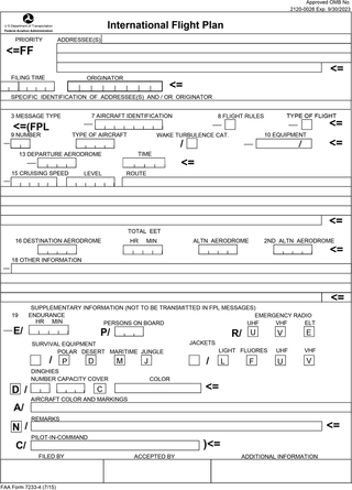
Flight plans are documents filed by a pilot or flight dispatcher with the local Air Navigation Service Provider prior to departure which indicate the plane's planned route or flight path. Flight plan format is specified in ICAO Doc 4444. They generally include basic information such as departure and arrival points, estimated time en route, alternate airports in case of bad weather, type of flight, the pilot's information, number of people on board, and information about the aircraft itself. In most countries, flight plans are required for flights under IFR, but may be optional for flying VFR unless crossing international borders. Flight plans are highly recommended, especially when flying over inhospitable areas such as water, as they provide a way of alerting rescuers if the flight is overdue. In the United States and Canada, when an aircraft is crossing the Air Defense Identification Zone (ADIZ), either an IFR or a special type of VFR flight plan called a DVFR flight plan must be filed. For IFR flights, flight plans are used by air traffic control to initiate tracking and routing services. For VFR flights, their only purpose is to provide needed information should search and rescue operations be required, or for use by air traffic control when flying in a "Special Flight Rules Area."
The world's navigable airspace is divided into three-dimensional segments, each of which is assigned to a specific class. Most nations adhere to the classification specified by the International Civil Aviation Organization (ICAO) and described below, though they might use only some of the classes defined below, and significantly alter the exact rules and requirements. Similarly, individual nations may also designate special use airspace (SUA) with further rules for reasons of national security or safety.

In air traffic control, an area control center (ACC), also known as a center or en-route center, is a facility responsible for controlling aircraft flying in the airspace of a given flight information region (FIR) at high altitudes between airport approaches and departures. In the US, such a center is referred to as an air route traffic control center (ARTCC).
Direct User Access Terminal Service (DUATS) was a weather information and flight plan processing service contracted by the Federal Aviation Administration (FAA) in 1989 for use by United States civil pilots and other authorized users. The DUAT Service was a telephone- and Internet-based system which allowed the pilot to use a personal computer for access to a Federal Aviation Administration (FAA) database to obtain weather and aeronautical information and to file, amend, and cancel domestic IFR and VFR flight plans. DUATS provided direct access to weather information via a National Airspace System (NAS) Data Interchange Network II (NADIN-II) interface to the Weather Message Switching Center Replacement (WMSCR) System and the Air traffic control (ATC) Facilities for filing flight plans. The pilot users could interface DUAT Services via the FTS-2001 toll free telephone numbers or via an Internet Interface into the Contractor's Facility. The service could be accessed by direct dial, and the Internet via Telnet or HTTP.

Special use airspace (SUA) is a type of special airspaces in the United States designated for operations of a nature such that limitations may be imposed on aircraft not participating in those operations. Often these operations are of a military nature. The designation of SUAs identifies for other users the areas where such activity occurs, provides for segregation of that activity from other users, and allows charting to keep airspace users informed of potential hazards.

In United States aviation, a sectional aeronautical chart, often called a sectional chart or a sectional for short, is a type of aeronautical chart designed for air navigation under visual flight rules (VFR).
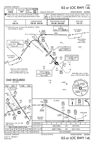
Approach plates are the printed or digital charts of instrument approach procedures that pilots use to fly instrument approaches during instrument flight rules (IFR) operations. Each country maintains its own instrument approach procedures according to International Civil Aviation Organization (ICAO) standards.

Standard instrument departure (SID) routes are published flight procedures followed by aircraft on an IFR flight plan immediately after takeoff from an airport. SIDs are one of the two types of departure procedures (DP); the other type being Obstacle Departure Procedures.

The United States airspace system's classification scheme is intended to maximize pilot flexibility within acceptable levels of risk appropriate to the type of operation and traffic density within that class of airspace – in particular to provide separation and active control in areas of dense or high-speed flight operations.
In United States and Canada aviation, terminal area charts are aeronautical charts intended for navigation under Visual Flight Rules that depict areas surrounding major airports, primarily those with Class B airspace.
This article describes the graphic conventions used in Sectional charts and Terminal area charts published for aeronautical navigation under Visual Flight Rules in the United States of America. The charts are published "in accordance with Interagency Air Cartographic Committee specifications and agreements, approved by the Department of Defense and the Federal Aviation Administration".

In the United States and Canada, Victor airways are low-altitude airways. They are defined in straight-line segments, each of which is based on a straight line between either two VHF omnidirectional range (VOR) stations, or a VOR and a VOR intersection, hence the beginning letter V.
Karachi Area Control Centre is one of two Area Control Centers in Pakistan operated by the Pakistan Civil Aviation Authority and is based in Terminal 1 at Jinnah International Airport in Karachi. Karachi ACC air traffic controllers provide en route and terminal control services to aircraft in the Karachi Flight Information Region. The Karachi FIR airspace covers Pakistani airspace between the 30° North to 23° North. To the north is the Lahore FIR. To the east is the Delhi FIR. To the south is the Muscat FIR and to the west are the Tehran FIR and Kabul FIRs.
Lahore Area Control Centre is one of three Area Control Centers in Pakistan operated by the Pakistan Civil Aviation Authority and based at Allama Iqbal International Airport in Lahore. Lahore ACC air traffic controllers provide en route and terminal control services to aircraft in the Lahore Flight Information Region (FIR). The Lahore FIR airspace covers Pakistani airspace between the 30° North to 37° North. To the south is the Karachi FIR. To the north is the Urumqi FIR. To the east is the Delhi FIR. To the west is the Kabul FIR.

ForeFlight is an electronic flight bag for iOS and iPadOS devices designed to assist pilots and corporate flight departments with flight planning. It includes information about facilities such as airports, NAVAIDs, and air traffic control facilities. It also aids pilots in tasks including flight planning, weather monitoring, and document management, as well as an electronic logbook to help pilots record flight time. The United States, Canada, and Europe are supported regions. The company was founded in 2007 and has since been purchased by Boeing.