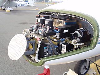
Avionics are the electronic systems used on aircraft. Avionic systems include communications, navigation, the display and management of multiple systems, and the hundreds of systems that are fitted to aircraft to perform individual functions. These can be as simple as a searchlight for a police helicopter or as complicated as the tactical system for an airborne early warning platform.

A waypoint is a point or place on a route or line of travel, a stopping point, an intermediate point, or point at which course is changed, the first use of the term tracing to 1880. In modern terms, it most often refers to coordinates which specify one's position on the globe at the end of each "leg" (stage) of an air flight or sea passage, the generation and checking of which are generally done computationally.

A head-up display, or heads-up display, also known as a HUD or head-up guidance system (HGS), is any transparent display that presents data without requiring users to look away from their usual viewpoints. The origin of the name stems from a pilot being able to view information with the head positioned "up" and looking forward, instead of angled down looking at lower instruments. A HUD also has the advantage that the pilot's eyes do not need to refocus to view the outside after looking at the optically nearer instruments.
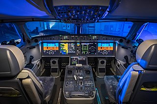
A glass cockpit is an aircraft cockpit that features an array of electronic (digital) flight instrument displays, typically large LCD screens, rather than traditional analog dials and gauges. While a traditional cockpit relies on numerous mechanical gauges to display information, a glass cockpit uses several multi-function displays and a primary flight display driven by flight management systems, that can be adjusted to show flight information as needed. This simplifies aircraft operation and navigation and allows pilots to focus only on the most pertinent information. They are also popular with airline companies as they usually eliminate the need for a flight engineer, saving costs. In recent years the technology has also become widely available in small aircraft.

Garmin Ltd. is an American, Swiss-domiciled multinational technology company founded in 1989 by Gary Burrell and Min Kao in Lenexa, Kansas, United States, with operational headquarters in Olathe, Kansas. Since 2010, the company is legally incorporated in Schaffhausen, Switzerland.

An automotive navigation system is part of the automobile controls or a third party add-on used to find direction in an automobile. It typically uses a satellite navigation device to get its position data which is then correlated to a position on a road. When directions are needed routing can be calculated. On the fly traffic information can be used to adjust the route.

In aviation, an electronic flight instrument system (EFIS) is a flight instrument display system in an aircraft cockpit that displays flight data electronically rather than electromechanically. An EFIS normally consists of a primary flight display (PFD), multi-function display (MFD), and an engine indicating and crew alerting system (EICAS) display. Early EFIS models used cathode-ray tube (CRT) displays, but liquid crystal displays (LCD) are now more common. The complex electromechanical attitude director indicator (ADI) and horizontal situation indicator (HSI) were the first candidates for replacement by EFIS. Now, however, few flight deck instruments cannot be replaced by an electronic display.

The Garmin G1000 is an electronic flight instrument system (EFIS) typically composed of two display units, one serving as a primary flight display, and one as a multi-function display. Manufactured by Garmin Aviation, it serves as a replacement for most conventional flight instruments and avionics. Introduced in June 2004, the system has since become one of the most popular integrated glass cockpit solutions for general aviation and business aircraft.

The Yeoman Plotter was a plotter used on ships and boats to transfer GPS coordinates or RADAR echo locations onto a paper navigation chart and to read coordinates from the chart. It was manufactured from 1985 to 2014/2015 and was an intermediary step between traditional paper chart navigation and full electronic chart displays. It was easy to understand for people that were accustomed to paper charts and much cheaper than electronic chart displays available at the time. The continuing fall in prices of electronic chart displays, their increase in functionality such as radar overlay and the advent of cheap tablets eventually made the Yeoman plotter uncompetitive.

Since the Global Positioning System (GPS) was introduced in the late 1980s there have been many attempts to integrate it into a navigation-assistance system for blind and visually impaired people.

An electronic flight bag (EFB) is an electronic information management device that helps flight crews perform flight management tasks more easily and efficiently with less paper providing the reference material often found in the pilot's carry-on flight bag, including the flight-crew operating manual, navigational charts, etc. In addition, the EFB can host purpose-built software applications to automate other functions normally conducted by hand, such as take-off performance calculations. The EFB gets its name from the traditional pilot's flight bag, which is typically a heavy documents bag that pilots carry to the cockpit.
Global Navigation Satellite System (GNSS) receivers, using the GPS, GLONASS, Galileo or BeiDou system, are used in many applications. The first systems were developed in the 20th century, mainly to help military personnel find their way, but location awareness soon found many civilian applications.
Satellite navigation software or GNSS navigation software a category of software that provide positioning services by utilizing data from satellite navigation systems.
L-3 SmartDeck - is a fully integrated cockpit system originally developed by L-3 Avionics Systems. and acquired in 2010 by Esterline CMC Electronics through an exclusive licensing agreement.

A satellite navigation device or satnav device, also known as a satellite navigation receiver or satnav receiver or simply a GPS device, is a user equipment that uses satellites of the Global Positioning System (GPS) or similar global navigation satellite systems (GNSS). A satnav device can determine the user's geographic coordinates and may display the geographical position on a map and offer routing directions.

OpenSeaMap is a software project collecting freely usable nautical information and geospatial data to create a worldwide nautical chart. This chart is available on the OpenSeaMap website, and can also be downloaded for use as an electronic chart for offline applications.

Sygic is a Slovak company of global automotive navigation systems for mobile phones and tablets. The company was founded in 2004 and is headquartered in Bratislava, Slovakia. It became the first company to offer navigation for iPhone and second for Android. In 2015 Sygic reached milestone of 100 million downloads of its navigation app.

Toyota Entune is an integrated multimedia navigation and telematics system for Toyota automobiles that provides satellite-based information on traffic, weather, sports scores, stocks, and fuel prices via subscription through SiriusXM. When connected to a compatible mobile phone running the Entune app via radio or USB cable, the system provides a browser and other apps, including music services such as iHeartRadio, Pandora and XM Satellite Radio. The cell phone app supported iOS, Android, and Blackberry with different versions utilizing cell data. The system could be controlled with (limited) speech recognition, and optionally include the “Safety Connect” personalization system.
Avare is a free open source "moving map" aviation GPS, A/FD and EFB app for phones or tablets using the Android Operating System. The app uses any internal Android or compatible external GPS receiver to determine location, allowing real-time display of location, heading, speed, distance, time, and altitude on free U.S. FAA IFR or VFR aviation charts; or on select topographic charts. Included are 3D, ADSB-In and other advanced options. The user can access all relevant static current FAA official data and some non-FAA maps and data in flight without data connection, once data has been downloaded to the device. With an aircraft ADSB-Out transmitter and inexpensive ADSB-In receiver Avare can also display any available FAA live ADSB data in flight. Some advanced users also interface Avare with an auto-pilot or flight simulator.

Locus Map is a multi-functional Android navigation app. Primarily it is designed and used for leisure time outdoor activities like hiking, biking, or geocaching. The app is also used by professionals e.g. by S&R teams or for collecting geospatial data.


