
In aviation, instrument flight rules (IFR) is one of two sets of regulations governing all aspects of civil aviation aircraft operations; the other is visual flight rules (VFR).
In aviation, visual flight rules (VFR) are a set of regulations under which a pilot operates an aircraft in weather conditions generally clear enough to allow the pilot to see where the aircraft is going. Specifically, the weather must be better than basic VFR weather minima, i.e., in visual meteorological conditions (VMC), as specified in the rules of the relevant aviation authority. The pilot must be able to operate the aircraft with visual reference to the ground, and by visually avoiding obstructions and other aircraft.

Airspace is the portion of the atmosphere controlled by a country above its territory, including its territorial waters or, more generally, any specific three-dimensional portion of the atmosphere. It is not the same as aerospace, which is the general term for Earth's atmosphere and the outer space in its vicinity.

In aviation, visual meteorological conditions (VMC) is an aviation flight category in which visual flight rules (VFR) flight is permitted—that is, conditions in which pilots have sufficient visibility to fly the aircraft maintaining visual separation from terrain and other aircraft. They are the opposite of instrument meteorological conditions (IMC). The boundary criteria between IMC and VMC are known as the VMC minima and are defined by: visibility, cloud ceilings, and cloud clearances.

In the United States, airways or air routes are defined by the Federal Aviation Administration (FAA) in two ways:
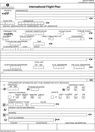
Flight plans are documents filed by a pilot or flight dispatcher with the local Air Navigation Service Provider prior to departure which indicate the plane's planned route or flight path. Flight plan format is specified in ICAO Doc 4444. They generally include basic information such as departure and arrival points, estimated time en route, alternate airports in case of bad weather, type of flight, the pilot's information, number of people on board, and information about the aircraft itself. In most countries, flight plans are required for flights under IFR, but may be optional for flying VFR unless crossing international borders. Flight plans are highly recommended, especially when flying over inhospitable areas such as water, as they provide a way of alerting rescuers if the flight is overdue. In the United States and Canada, when an aircraft is crossing the Air Defense Identification Zone (ADIZ), either an IFR or a special type of VFR flight plan called a DVFR flight plan must be filed. For IFR flights, flight plans are used by air traffic control to initiate tracking and routing services. For VFR flights, their only purpose is to provide needed information should search and rescue operations be required, or for use by air traffic control when flying in a "Special Flight Rules Area."
In general aviation, scud running is a practice in which pilots lower their altitude to avoid clouds or instrument meteorological conditions (IMC). The goal of scud running is to stay clear of weather to continue flying with visual, rather than instrument, references. This practice is widely accepted to be dangerous, and has led to death in many cases from pilots flying into terrain or obstacles, such as masts and towers, normally referred to as controlled flight into terrain, or CFIT; however, even instrument-rated pilots sometimes elect to take the risk to avoid icing or embedded thunderstorms in cloud, or in situations where the minimum instrument altitudes are too high for their aircraft.
The world's navigable airspace is divided into three-dimensional segments, each of which is assigned to a specific class. Most nations adhere to the classification specified by the International Civil Aviation Organization (ICAO) and described below, though they might use only some of the classes defined below, and significantly alter the exact rules and requirements. Similarly, individual nations may also designate special use airspace (SUA) with further rules for reasons of national security or safety.
Minimum Obstacle Clearance Altitude, or MOCA, is the lowest published altitude in effect between fixes on VOR airways or route segments that meets obstacle clearance requirements for the entire route segment. Within the United States, this altitude also assures acceptable navigational signal coverage only within 22 nm of a VOR. The MOCA seen on the NACO en route chart, may have been computed by adding the required obstacle clearance (ROC) to the controlling obstacle in the primary area or computed by using a TERPS chart if the controlling obstacle is located in the secondary area. This figure is then rounded to the nearest 100 foot increment, i.e. 2,049 feet becomes 2,000, and 2,050 feet becomes 2,100 feet. An extra 2,000 feet is added in mountainous areas, 1,000 in non-mountainous. The MOCA is based upon obstacle clearance over the terrain or over manmade objects, adequacy of navigation facility performance, and communications requirements. The MOCA is always at or below the Minimum en route altitude (MEA), and may put an aircraft below air traffic control radar coverage and also below Minimum reception altitude (MRA) for navigation aids; as a result, it is typically used only in emergencies, especially to get below icing.
Minimum en route altitude (MEA), alternately spelled as Minimum enroute altitude, is the lowest published altitude between radio navigation fixes that assures acceptable navigational signal coverage and meets obstacle clearance requirements between those fixes.
In aviation, minimum reception altitude (MRA) is the lowest altitude on an airway segment where an aircraft can be assured of receiving signals from off-course navigation aids like VOR that define a fix. An MRA is determined by FAA flight inspection traversing an entire route of flight to establish the minimum altitude the navigation signal can be received for the route (which, along with obstacle clearance, defines the Minimum Enroute Altitude - MEA) and for off-course NAVAID facilities that determine a fix. When the MRA at the fix is higher than the MEA, an MRA is established for the fix, and is the lowest altitude at which an intersection can be determined.

In aviation, an instrument approach or instrument approach procedure (IAP) is a series of predetermined maneuvers for the orderly transfer of an aircraft operating under instrument flight rules from the beginning of the initial approach to a landing, or to a point from which a landing may be made visually. These approaches are approved in the European Union by EASA and the respective country authorities and in the United States by the FAA or the United States Department of Defense for the military. The ICAO defines an instrument approach as, "a series of predetermined maneuvers by reference to flight instruments with specific protection from obstacles from the initial approach fix, or where applicable, from the beginning of a defined arrival route to a point from which a landing can be completed and thereafter, if landing is not completed, to a position at which holding or en route obstacle clearance criteria apply."
In aviation, atmospheric sciences and broadcasting, a height above ground level is a height measured with respect to the underlying ground surface. This is as opposed to height above mean sea level, height above ellipsoid, or height above average terrain. In other words, these expressions indicate where the "zero level" or "reference altitude" - the vertical datum - is located.
Special visual flight rules are a set of aviation regulations under which a pilot may operate an aircraft. It is a special case of operating under visual flight rules (VFR).
Standard instrument departure (SID) routes, also known as departure procedures (DP), are published flight procedures followed by aircraft on an IFR flight plan immediately after takeoff from an airport.
The United States airspace system's classification scheme is intended to maximize pilot flexibility within acceptable levels of risk appropriate to the type of operation and traffic density within that class of airspace – in particular to provide separation and active control in areas of dense or high-speed flight operations.
In aviation, an en-route chart is an aeronautical chart that guides pilots flying under instrument flight rules (IFR) during the en-route phase of flight.
In aviation, a minimum crossing altitude (MCA) is the lowest altitude at which a navigational fix can be crossed when entering or continuing along an airway that will allow an aircraft to clear all obstacles while carrying out a normal climb to the required minimum en route IFR altitude (MEA) of the airway in question beyond the fix.

In the United States and Canada, Victor airways are low-altitude airways. They are defined in straight-line segments, each of which is based on a straight line between either two VHF omnidirectional range (VOR) stations, or a VOR and a VOR intersection, hence the beginning letter V.
Maximum elevation figure (MEF) is a type of visual flight rule (VFR) information that indicates the elevation of the highest geographical feature within a GEOREF quadrangle area. It is of interest to pilots, who want to be aware of the highest mountain peaks and tall towers nearby, so that they can fly above them to avoid controlled flight into terrain.