Borough of Bedford

Last updated

Bedford
Borough of Bedford
CountyHallRearBedford.JPG
Bedford arms.svg
Bedford UK locator map.svg
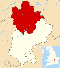
Bedford shown within Bedfordshire
Coordinates: 52°8′0″N0°27′0″W / 52.13333°N 0.45000°W / 52.13333; -0.45000
Sovereign state Flag of the United Kingdom.svg United Kingdom
Country Flag of England.svg England
Region East of England
Ceremonial county Bedfordshire
Administrative HQ Borough Hall, Bedford
Government
  Type Unitary Authority
  Governing body Bedford Borough Council
   MPs Richard Fuller (C)
Alistair Strathern (L)
Mohammad Yasin (L)
Area
  Total476.4 km2 (183.9 sq mi)
Population
 (2021) [1]
  Total185,761
  Rank 107th
  Density390/km2 (1,000/sq mi)
  Ethnicity
85.5% White British
8.1% British Asian
2.9% Black British
1.3% Chinese or other
2.2% Mixed
Time zone GMT
  Summer (DST) British Summer Time
ONS code 00KB
NUTS 3UKH22
Website www.bedford.gov.uk OOjs UI icon edit-ltr-progressive.svg

The Borough of Bedford is a unitary authority area with borough status in the ceremonial county of Bedfordshire, England. Its council is based in Bedford, its namesake and principal settlement, which is the county town of Bedfordshire. The Bedford built-up-area is the 71st largest in the United Kingdom and comprises the boundaries of the pre-1974 Bedford Municipal Borough, the town of Kempston and the village of Biddenham, [2] with the BUA surrounded by a rural area with many villages. 75% of the borough's population live in the Bedford Urban Area and the five large villages which surround it, which makes up slightly less than 6% of the total land area of the Borough.

Contents

The borough is also the location of the Wixams new town development, which received its first residents in 2009.

History

The ancient borough of Bedford was a borough by prescription, with its original date of incorporation unknown. The earliest surviving charter was issued c. 1166 by Henry II, confirming to the borough the liberties and customs which it had held in the reign of Henry I. [3] [4] The borough became a municipal borough under the Municipal Corporations Act 1835.

The District of Bedford was formed on 1 April 1974 as a merger of the existing borough of Bedford, along with Kempston Urban District and Bedford Rural District. In 1975 the district was granted a royal charter granting borough status as North Bedfordshire. [5] The borough changed its name back from North Bedfordshire to Bedford in 1992. [6]

Bedfordshire's administrative structure was reorganised as part of the 2009 structural changes to local government in England, meaning that Bedford Borough Council became a unitary authority in April 2009. Bedford Borough Council assumed responsibility in areas such as education, social services and transport which were previously provided by Bedfordshire County Council. [7] [8] [9]

Governance

The council is based at Borough Hall on Cauldwell Street on the banks of the River Great Ouse in the centre of Bedford. The building was previously known as County Hall and had been the headquarters of Bedfordshire County Council prior to 2009. The unitary authority area is divided into 28 wards for elections to the Borough Council. [10]

Parishes

Most of the area of the pre-1974 municipal borough of Bedford is unparished, although the parish of Brickhill was created within that area in 2004. The rest of the modern borough, including Kempston (the borough's only CP with a town council), is parished. The parishes are: [11]

Freedom of the Borough

The following people and military units have received the Freedom of the Borough of Bedford.

Individuals

Military Units

See also

Related Research Articles

<span class="mw-page-title-main">Bedfordshire</span> County of England

Bedfordshire is a ceremonial and historic county in the East of England. It is bordered by Northamptonshire to the north, Cambridgeshire to the north-east, Hertfordshire to the south and the south-east, and Buckinghamshire to the west. The largest settlement is Luton which had a population of 225,262 in 2021.

<span class="mw-page-title-main">Bedford</span> Town in Bedfordshire, England

Bedford is a market town in Bedfordshire, England. At the 2011 Census, the population of its urban area, including Kempston and Biddenham, was 106,940. Bedford is also the county town of Bedfordshire and seat of the Borough of Bedford, a unitary authority that includes a significant rural area.

<span class="mw-page-title-main">Kempston</span> Human settlement in England

Kempston is a town and civil parish in the Borough of Bedford, Bedfordshire, England, situated around 2 miles (3.2 km) south-west of Bedford town centre. It had a population of 19,330 in the 2011 census, and forms part of the wider Bedford built-up area. The River Great Ouse separates it from the Queen's Park area of Bedford.

<span class="mw-page-title-main">History of Bedfordshire</span> History of Bedfordshire County in England

Bedfordshire is an English ceremonial county which lies between approximately 25 miles and 55 miles north of central London.

<span class="mw-page-title-main">Civil parishes in Bedfordshire</span> List of places

A civil parish is a country subdivision, forming the lowest unit of local government in England. There are 125 civil parishes in the ceremonial county of Bedfordshire, most of the county being parished: Luton is completely unparished; Central Bedfordshire is entirely parished. At the 2001 census, there were 312,301 people living in the 125 parishes, which accounted for 55.2 per cent of the county's population.

<span class="mw-page-title-main">Bedford (UK Parliament constituency)</span> Parliamentary constituency in the United Kingdom from 1801 to 1983 and from 1997 onwards

Bedford is a constituency represented in the House of Commons of the UK Parliament since 2017 by Mohammad Yasin of the Labour Party.

<span class="mw-page-title-main">Kempston Rural</span> Human settlement in England

Kempston Rural is a civil parish in the Borough of Bedford in Bedfordshire, England.

<span class="mw-page-title-main">Brickhill</span> Human settlement in England

Brickhill is a civil parish and electoral ward within northern Bedford in Bedfordshire, England.

Bedford Rural District was a rural district in Bedfordshire, England from 1894 to 1974. It surrounded but did not include the Municipal Borough of Bedford and Kempston Urban District.

Bedford Borough Council is the local authority for the unitary authority of Bedford in Bedfordshire, England. Until 1 April 2009 it was a non-metropolitan district. Since 2002 it has also had a directly elected mayor.

<span class="mw-page-title-main">North Bedfordshire (UK Parliament constituency)</span> Parliamentary constituency in the United Kingdom, 1983–1997

North Bedfordshire was a county constituency in Bedfordshire. It returned one Member of Parliament (MP) to the House of Commons of the Parliament of the United Kingdom, elected by the first-past-the-post voting system.

<span class="mw-page-title-main">Edworth</span> Human settlement in England

Edworth is a hamlet and civil parish in the Central Bedfordshire district of the county of Bedfordshire, England about 12 miles (19 km) south-east of the county town of Bedford. It sits just off the Great North Road (A1) between Baldock and Biggleswade. There are fewer than one hundred inhabitants. At the 2011 Census, Edworth's population was amalgamated with the civil parish of Dunton.

<span class="mw-page-title-main">Biddenham International School and Sports College</span> Foundation school in Biddenham, Bedfordshire, England

Biddenham International School and Sports College is a mixed secondary school and sixth form located in Biddenham in the English county of Bedfordshire.

<span class="mw-page-title-main">Bedford College, Bedford</span> Further education school in Bedford, Bedfordshire, England

Bedford College is a further education college located in Bedford, Bedfordshire, England. It is the principal further education provider in the Borough of Bedford, and is a member of the Collab Group of high performing schools.

<span class="mw-page-title-main">Central Bedfordshire</span> District in England

Central Bedfordshire is a unitary authority area in the ceremonial county of Bedfordshire, England. It was created in 2009.

St John’s School and College is a mixed special school located in Kempston, Bedfordshire, England. The school educates pupils ages 2 to 19 from all over the Borough of Bedford.

<span class="mw-page-title-main">Kempston Barracks</span>

Kempston Barracks is a military installation at Kempston in Bedfordshire.

References

  1. "Mid-Year Population Estimates, UK, June 2021". Office for National Statistics. 21 December 2022. Retrieved 18 October 2023.
  2. UK Census (2011). "Local Area Report – Bedford Built-up Area (E34004993)". Nomis. Office for National Statistics . Retrieved 26 July 2019.
  3. Page, William, ed. (1912). "The Borough of Bedford". A History of the County of Bedford: Volume 3. British History Online. Retrieved 8 August 2021.
  4. "Bedford Borough records introduction". Bedfordshire Archives. Retrieved 8 August 2021.
  5. North Bedfordshire Borough Council, London Gazette, 31 October 1975, page 13813. Change of name and status from Bedford District to North Bedfordshire Borough with effect from 16 October 1975.
  6. Bulletin of Changes of Local Authority Status, Names and Areas, 1 April 1992 - 31 March 1993 (Department of the Environment). Change of name from North Bedfordshire to Bedford effective from 1 October 1992.
  7. Unitary solution confirmed for Bedfordshire – New flagship unitary councils approved for Cheshire – Corporate – Communities and Local Government Archived 22 November 2008 at the Wayback Machine
  8. County council to be abolished in shake-up – Bedford Today
  9. A New Beginning Archived 24 February 2009 at archive.today
  10. "Wards and polling district maps". Bedford Borough Council. Retrieved 3 December 2023.
  11. "Election Maps". Ordnance Survey. Retrieved 10 May 2023.
  12. "Olympic canoeist Etienne Stott given freedom of Bedford". BBC News. 11 December 2012.
  13. "RAF Cardington Camp". rafcardingtoncamp.co.uk.
  14. "In pictures: Royal Anglians march through Bedford". BBC News. 22 July 2014.

52°08′04″N0°27′47″W / 52.13444°N 0.46306°W / 52.13444; -0.46306