Cheshire East

Last updated

Cheshire East
Municipal Buildings, Crewe.jpg
Crewe, a historic railway town and the largest town in Cheshire East
Coat of arms of Cheshire East Borough Council.png
Motto: 
Working together for excellence
Cheshire East UK locator map.svg
Cheshire East shown within Cheshire
Coordinates: 53°08′46″N2°22′01″W / 53.146°N 2.367°W / 53.146; -2.367
Sovereign state United Kingdom
Country England
Region North West
Ceremonial county Cheshire
Incorporated1 April 2009
Administrative HQ Sandbach
Government
[1]
  Type Unitary authority with committee system
  Body Cheshire East Council
   Control Labour and Independent coalition
  LeaderSam Corcoran (L)
   Mayor Rod Fletcher
   Chief Executive Rob Polkinghorne
   House of Commons
Area
[2]
  Total450 sq mi (1,166 km2)
  Rank 19th
Population
 (2021) [3]
  Total400,528
  Rank 16th
  Density890/sq mi (343/km2)
Ethnicity (2021)
[4]
   Ethnic groups
List
Religion (2021)
[4]
   Religion
List
Time zone UTC+0 (GMT)
  Summer (DST) UTC+1 (BST)
Postcode areas
Dialling codes
  • 01260
  • 01270
  • 01477
  • 01565
  • 01606
  • 01625
  • 01829
  • 01948
ISO 3166 code GB-CHE
GSS code E06000049
ITL code TLD62
GVA 2021 estimate [5]
 Total £14.6 billion
 Per capita£36,559
GDP (nominal)2021 estimate [5]
 Total£16.1 billion
 Per capita£40,142
Website cheshireeast.gov.uk

Cheshire East is a unitary authority area with borough status in Cheshire, England. The local authority is Cheshire East Council. Towns within the area include Crewe, Macclesfield, Congleton, Sandbach, Wilmslow, Handforth, Knutsford, Poynton, Bollington, Alsager and Nantwich. The council is based in the town of Sandbach.

Contents

History

The borough council was established in April 2009 as part of the 2009 structural changes to local government in England, by virtue of an order under the Local Government and Public Involvement in Health Act 2007. [6] It is an amalgamation of the former boroughs of Macclesfield, Congleton and Crewe and Nantwich, and includes the functions of the former Cheshire County Council. The residual part of the disaggregated former County Council, together with the other three former Cheshire borough councils (Chester City, Ellesmere Port & Neston and Vale Royal) were, similarly, amalgamated to create the new unitary council of Cheshire West and Chester.

Cheshire East has historic links to textile mills of the industrial revolution, such as seen at Quarry Bank Mill. It is also home to Tatton Park, a historic estate that hosts RHS Show Tatton Park.

Geography

Cheshire East lies within North West England. It borders Cheshire West and Chester to the west, Greater Manchester to the north, Derbyshire to the east as well as Staffordshire and Shropshire to the south. It is home to the Cheshire Plain and the southern hills of the Pennines. The local geology is mostly glacial clay, as well as glacial sands and gravel.

Climate

According to the Köppen climate classification, like most areas of the UK, the climate is classified as “oceanic” or “Cfb”.

Demography

Historical population
YearPop.±%
1981 328,500    
1986 331,700+1.0%
1991 340,500+2.7%
1996 349,900+2.8%
2001 352,100+0.6%
2006 362,000+2.8%
2011 370,700+2.4%
2016 381,400+2.9%
2021 400,500+5.0%
All totals rounded to nearest hundred
Source: NOMIS
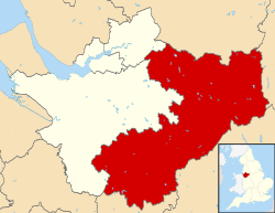
The population of Cheshire East is 400,528 (2021). [3]

Ethnicity

According to the 2021 Census, ethnic white groups account for 94.4% of the population (376,543 people), with 5.6% of the population (22,229 people) being in ethnic groups other than white (Asian, Black, Mixed, Other). [4]

Religion

A breakdown of religious groups: [4]

Administration

Wards

The 52 wards of Cheshire East are: [7]

  1. Alderley Edge
  2. Alsager
  3. Audlem
  4. Bollington
  5. Brereton Rural
  6. Broken Cross and Upton
  7. Bunbury
  8. Chelford
  9. Congleton East
  10. Congleton West
  11. Crewe Central
  12. Crewe East
  13. Crewe North
  14. Crewe South
  15. Crewe St Barnabas
  16. Crewe West
  17. Dane Valley
  18. Disley
  19. Gawsworth
  20. Handforth
  21. Haslington
  22. High Legh
  23. Knutsford
  24. Leighton
  25. Macclesfield Central
  26. Macclesfield East
  27. Macclesfield Hurdsfield
  28. Macclesfield South
  29. Macclesfield Tytherington
  30. Macclesfield West and Ivy
  31. Middlewich
  32. Mobberley
  33. Nantwich North and West
  34. Nantwich South and Stapeley
  35. Odd Rode
  36. Poynton East and Pott Shrigley
  37. Poynton West and Adlington
  38. Prestbury
  39. Sandbach Elworth
  40. Sandbach Ettiley Heath and Wheelock
  41. Sandbach Heath and East
  42. Sandbach Town
  43. Shavington
  44. Sutton (Sutton Lane Ends)
  45. Willaston and Rope
  46. Wilmslow Dean Row
  47. Wilmslow East
  48. Wilmslow Lacey Green
  49. Wilmslow West and Chorley
  50. Wistaston
  51. Wrenbury
  52. Wybunbury
Ward Civil parishes [Note 1]
and unparished areas
House of Commons
constituency
Alderley Edge Alderley Edge Tatton
Alsager Alsager Congleton
Audlem Audlem Eddisbury
Austerson
Baddington
Broomhall
Buerton
Coole Pilate
Dodcott cum Wilkesley
Hankelow
Newhall
Sound
Bollington Bollington Macclesfield
Higher Hurdsfield
Brereton Rural Arclid Congleton
Betchton
Bradwall
Brereton
Hassall
Hulme Walfield
Moston
Smallwood
Somerford
Somerford Booths
Swettenham
Warmingham Crewe and Nantwich
Broken Cross and Upton Macclesfield Macclesfield
Bunbury Acton Eddisbury
Alpraham
Aston juxta Mondrum
Bunbury
Calveley
Cholmondeston
Church Minshull
Henhull
Hurleston
Minshull Vernon
Poole
Stoke
Wardle
Wettenhall
Worleston
Chelford Bexton Tatton
Chelford
Marthall
Nether Alderley
Ollerton
Peover Inferior
Peover Superior
Plumley
Snelson
Toft
Congleton East Congleton Congleton
Congleton West Congleton
Crewe Central Crewe Crewe and Nantwich
Crewe East Crewe
Crewe North Crewe
Crewe South Crewe
Shavington cum Gresty
Crewe St Barnabas Crewe
Crewe West Crewe
Haslington Barthomley
Basford
Crewe Green
Haslington
Weston
Knutsford Knutsford Tatton
Leighton Crewe Crewe and Nantwich
Leighton
Leighton Eddisbury
Macclesfield Central Macclesfield Macclesfield
Macclesfield East Macclesfield
Macclesfield Hurdsfield Macclesfield
Macclesfield South Macclesfield
Macclesfield Tytherington Macclesfield
Macclesfield West and Ivy Macclesfield
Middlewich Middlewich Congleton
Nantwich North and West Nantwich Crewe and Nantwich
Nantwich South and Stapeley Batherton
Nantwich
Stapeley
Prestbury Mottram St Andrew Macclesfield
Over Alderley
Prestbury
Sandbach Elworth Sandbach Congleton
Sandbach Ettiley Heath and Wheelock Sandbach
Sandbach Heath and East Sandbach
Sandbach Town Sandbach
Shavington Shavington cum Gresty Crewe and Nantwich
Willaston and Rope Rope
Willaston
Wilmslow Dean Row Wilmslow Tatton
Wilmslow East Wilmslow
Wilmslow Lacey Green Styal
Wilmslow
Wilmslow West and Chorley Chorley
Wilmslow
Wistaston Willaston Crewe and Nantwich
Wistaston
Woolstanwood
Wrenbury Baddiley Eddisbury
Bickerton
Brindley
Bulkeley
Burland
Cholmondley
Chorley
Edleston
Egerton
Faddiley
Haughton
Marbury cum Quoisley
Norbury
Peckforton
Ridley
Spurstow
Wirswall
Wrenbury cum Frith
Wybunbury Blakenhall Crewe and Nantwich
Bridgemere
Checkley cum Wrinehill
Chorlton
Doddington
Hatherton
Hough
Hunsterson
Lea
Walgherton
Weston
Wybunbury
Notes
  1. ^
    1: Civil parishes highlighted in bold have unilaterally declared town status under section 12A of the Local Government Act 1972.

Members of Parliament

Constituency Member of Parliament Political party Year first electedNotesWebsiteParliamentary profile
Congleton Fiona Bruce Conservative Party 2010 Prime Minister's Special Envoy for Freedom of Religion or Belief Website Profile Official portrait of Fiona Bruce crop 2.jpg
Crewe and Nantwich Kieran Mullan 2019 Website Profile Official portrait of Dr Kieran Mullan MP crop 2.jpg
Eddisbury Edward Timpson 2019 Website Profile Official portrait of Edward Timpson MP crop 2.jpg
Macclesfield David Rutley 2010 Parliamentary Under-Secretary of State for Americas and Caribbean Website Profile Official portrait of David Rutley crop 2.jpg
Tatton The Rt Hon. Esther McVey 2017 Website Profile Official portrait of Esther McVey crop 2.jpg
MPs in Cheshire East, 2008 onwards [Note 2]
Election 2008 2010 2015 2017 2019
Congleton Ann Winterton Fiona Bruce
Crewe and Nantwich Edward Timpson Laura Smith Kieran Mullan
Eddisbury Stephen O'Brien Antoinette Sandbach Edward Timpson
Macclesfield Sir Nicholas Winterton David Rutley
Tatton George Osborne Esther McVey
Notes
  1. ^
    2: From the last election before the borough of Cheshire East was established.

Elections

At the last Cheshire County Council election in 2005 there were 15 Conservative controlled wards, 6 Labour controlled wards, 5 Liberal Democrat controlled wards and 1 ward controlled by an independent within the unitary authority boundaries. [8]

The first elections for Cheshire East Council took place on 1 May 2008, with the Conservative Party taking overall control. The Conservatives took 59 of the 81 seats with the others being held by the Liberal Democrats (12), Labour (6), 3 members of Middlewich First and one Independent. [9] The first leader of the authority was Wesley Fitzgerald who was elected at Cheshire East's inaugural meeting on 13 May 2008. Wesley Fitzgerald is a Councillor for the Wilmslow South ward. Having decided in February 2012 to step down, a leadership contest was triggered. Michael Jones – a relatively new councillor having been elected in the May 2011 elections – was elected as the Leader of the Conservative Group on 17 March 2012.

The administrative centre for Cheshire East Council is Westfields in Sandbach, the former Headquarters of Congleton Borough Council. [10] The site could be expanded if needed as there is space around the newly built centre. [11] Cheshire East is an observer member of the Association of Greater Manchester Authorities of Greater Manchester, which borders Cheshire to the north.

Transport

Roads

Motorways and primary routes in the borough which are maintained by National Highways (trunk roads de jure) include the M6, M56 and the A556. Other primary routes which are maintained by the council (principal roads de jure) include the A6, A34, A49, A50, A51, A54, A56, A500, A523, A525, A530, A534, A536, A537, A538, A555, A556, A5020 and A5033.

Major road projects

A556 Knutsford to Bowdon Improvement: A new five-mile four-lane dual-carriageway bypass of Bucklow Hill and Mere Crossroads on the A556 has been by Highways England at a cost of between £165-£221 million. The new road contains the first 'green bridge' wildlife crossing in the United Kingdom. The existing road has been narrowed to one lane in each direction and re-designated as the B5569 under the maintenance of Cheshire East Council. [12] [13]

M6 Junctions 16-19: Smart Motorway: Highways England are preparing to convert the hard shoulder to a permanent running lane and introduce a variable speed limit along this section of the M6, meaning that it will become the first smart motorway in Cheshire. The scheme is expected to cost between £192-£274 million. [14] However in Spring 2023 the Government abandoned all plans for further Smart Motorways to be constructed following concerns regarding their safety.

Crewe Green Link Road South: A dual-carriageway extension of Crewe Green Link Road is being constructed between the A5020 and Weston Gate Roundabout on the A500 by Cheshire East Council at a cost of £26.5 million. [15]

LED improvements: The Cheshire East Council, for multiple years now, has been investing in LEDs (light emitting diodes) as they are energy-efficient lights that are more likely to avoid sleepiness on the road as of their blue tint.

Rail

Buses

D&G bus is the primary operators of buses in cheshire east serving the county Monday to Saturday.Sunday services are limited to 84 Chester to Crewe operated by D&G bus ,3 crewe to hanley operated by First potteries and 58 operated by high peak Macclesfield to Chatsworth House via Buxton. Additional services are operated by Aimees travel, High Peak, Mikro coaches, and Stagecoach Manchester and Warrington own buses.

Local sites of interest

The area is home to a large number of sites of public interest:

Twin towns

The former borough of Macclesfield was twinned with Eckernförde, Germany. [34]

Congleton has been twinned with Trappes since 16 September 1962 [35]

Twinning remains active in the Crewe and Nantwich area. The town of Crewe began twinning with the town of Mâcon in France in 1957. This continued when the borough of Crewe and Nantwich was formed in 1974. The borough added the town of Bischofsheim in Germany in 1991. In 2003 the administration of twinning was passed to CANTA, the Crewe and Nantwich Twinning Association, a voluntary association supported by the borough. The association immediately added Dzierżoniów in Poland as a Friendship Town. The association has received continuing support from Cheshire East after the borough became part of the new authority. [36]

Related Research Articles

<span class="mw-page-title-main">Cheshire</span> County of England

Cheshire is a ceremonial county in North West England. It is bordered by Merseyside to the north-west, Greater Manchester to the north-east, Derbyshire to the east, Staffordshire to the south-east, and Shropshire to the south; to the west it is bordered by the Welsh counties of Flintshire and Wrexham, and has a short coastline on the Dee Estuary. Warrington is the largest settlement, and the city of Chester is the county town.

<span class="mw-page-title-main">Knutsford</span> Town in Cheshire, England

Knutsford is a market town in Cheshire, England; it is located 14 miles (23 km) south-west of Manchester, 9 miles (14 km) north-west of Macclesfield and 12+12 miles (20 km) south-east of Warrington. The population at the 2011 Census was 13,191.

<span class="mw-page-title-main">Macclesfield (borough)</span>

Macclesfield was, from 1974 to 2009, a local government district with borough status in Cheshire, England. It included the towns of Bollington, Knutsford, Macclesfield and Wilmslow and within its wider area the villages and hamlets of Adlington, Disley, Gawsworth, Kerridge, Pott Shrigley, Poynton, Prestbury, Rainow, Styal, Sutton and Tytherington.

<span class="mw-page-title-main">Wilmslow</span> Market town and civil parish in Cheshire, England

Wilmslow is a market town and civil parish in the unitary authority of Cheshire East in Cheshire, England, 11 mi (18 km) south of Manchester. The population was 24,497 at the 2011 Census.

<span class="mw-page-title-main">Civil parishes in Cheshire</span>

A civil parish is a country subdivision, forming the lowest unit of local government in England. There are 333 civil parishes in the ceremonial county of Cheshire, most of the county being parished. Cheshire East unitary authority is entirely parished. At the 2001 census, there were 565,259 people living in 332 parishes, accounting for 57.5 per cent of the county's population.

<span class="mw-page-title-main">Congleton (UK Parliament constituency)</span> Parliamentary constituency in the United Kingdom, 1983 onwards

Congleton is a parliamentary constituency in Cheshire, represented in the House of Commons of the UK Parliament since 2010 by Fiona Bruce of the Conservative Party.

<span class="mw-page-title-main">Tatton (UK Parliament constituency)</span> Parliamentary constituency in the United Kingdom

Tatton is a constituency in Cheshire represented in the House of Commons of the UK Parliament since 2017 by Esther McVey, a Conservative.

<span class="mw-page-title-main">Macclesfield (UK Parliament constituency)</span> Parliamentary constituency in the United Kingdom, 1885 onwards

Macclesfield is a constituency in Cheshire represented in the House of Commons of the UK Parliament since 2010 by David Rutley, a Conservative.

Betchton is a civil parish in the unitary authority of Cheshire East and the ceremonial county of Cheshire, England. According to the 2001 census it had a population of 620, increasing to 677 at the 2011 Census. The parish is immediately to the east of Sandbach, and includes Betchton Heath, Malkin's Bank and Hassall Green.

<span class="mw-page-title-main">Haslington</span> Human settlement in England

Haslington is a village and civil parish in the unitary authority of Cheshire East and the ceremonial county of Cheshire, England. It lies about 2 miles (3.2 km) north-east of the much larger railway town of Crewe and approximately 4 miles (6.4 km) south of Sandbach. The village was originally bisected by the A534 road that links Crewe with Sandbach, however, this road has now been re-routed to bypass the village to the north-west. The village is also a close neighbour to a number of small towns and villages, and is approximately 6 miles (9.7 km) from the Elizabethan market town of Nantwich.

<span class="mw-page-title-main">Crewe (UK Parliament constituency)</span> Parliamentary constituency in the United Kingdom, 1885–1983

Crewe was a constituency of the House of Commons of the Parliament of the United Kingdom from 1885 to 1983. It elected one Member of Parliament (MP) by the first past the post system of election.

<span class="mw-page-title-main">Knutsford (UK Parliament constituency)</span> Parliamentary constituency in the United Kingdom, 1885–1983

Knutsford was a county constituency in Cheshire which returned one Member of Parliament (MP) to the House of Commons of the Parliament of the United Kingdom from 1885 until it was abolished for the 1983 general election.

<span class="mw-page-title-main">Cheshire East (European Parliament constituency)</span> Constituency of the European Parliament

Prior to its uniform adoption of proportional representation in 1999, the United Kingdom used first-past-the-post for the European elections in England, Scotland and Wales. The European Parliament constituencies used under that system were smaller than the later regional constituencies and only had one Member of the European Parliament each.

<span class="mw-page-title-main">BakerBus</span>

BakerBus was the trading name used by the bus fleet of Bakers Coaches, a bus and coach operator based in Biddulph, Staffordshire, England. Formed as a coach operator in 1936, they grew to operate a fleet of around 50 vehicles on local bus services and coach hire work, but after several changes of ownership, ceased operation in 2018.

The ceremonial county of Cheshire, which comprises the unitary authorities of Cheshire East, Cheshire West and Chester, Halton and Warrington, has returned 11 MPs to the UK Parliament since 1997.

References

  1. "Council and Democracy". Cheshire East Council. Retrieved 13 January 2024.
  2. "Mid-Year Population Estimates, UK, June 2021". Office for National Statistics. 21 December 2022. Retrieved 18 October 2023.
  3. 1 2 "Mid-Year Population Estimates, UK, June 2021". Office for National Statistics. 21 December 2022. Retrieved 18 October 2023.
  4. 1 2 3 4 UK Census (2021). "2021 Census Area Profile – Cheshire East Local Authority (E06000049)". Nomis. Office for National Statistics . Retrieved 17 December 2023.
  5. 1 2 Fenton, Trevor (25 April 2023). "Regional gross domestic product: local authorities". Office for National Statistics. Retrieved 13 December 2023.
  6. "The Cheshire (Structural Changes) Order 2008". Archived from the original on 17 May 2009.
  7. "Ward Profiles". Cheshire East Council. Archived from the original on 9 March 2013. Retrieved 6 March 2013.
  8. Cheshire county council elections 2005. Archived 7 July 2013 at archive.today Retrieved 9 August 2007.
  9. "Council and Democracy". Cheshire East Council. Archived from the original on 18 August 2010. Retrieved 26 August 2010.
  10. Wilmslow Express Archived 28 August 2008 at the Wayback Machine Council's seat of power is Sandbach
  11. "Westfields to be extended". www.thisisstaffordshire.co.uk. Archived from the original on 3 August 2008. Retrieved 24 July 2008.
  12. "A556 Knutsford to Bowdon Improvement". Highways England. Archived from the original on 6 December 2015. Retrieved 5 December 2015.
  13. "B5569". The SABRE Wiki. Archived from the original on 8 December 2015. Retrieved 5 December 2015.
  14. "M6 Junctions 16-19: Smart Motorway". Highways England. Archived from the original on 13 December 2015. Retrieved 12 December 2015.
  15. "Crewe Green Link Road South". Cheshire East Council Highways Service. Archived from the original on 20 December 2015. Retrieved 12 December 2015.
  16. Tatton Park website. Archived 29 March 2009 at the Wayback Machine Retrieved 1 September 2007.
  17. Tatton Estate website. Archived 12 June 2015 at the Wayback Machine Retrieved 1 June 2015.
  18. Gawsworth Hall website. Archived 11 April 2009 at the Wayback Machine Retrieved 1 September 2007.
  19. "The Times & The Sunday Times". thetimes.co.uk. Retrieved 1 May 2018.
  20. Arley Hall and Gardens website. Archived 28 February 2009 at the Wayback Machine Retrieved 1 September 2007.
  21. Quarry Bank Mill website. Archived 7 April 2009 at the Wayback Machine Retrieved 1 September 2007.
  22. Capesthorne Hall website. Archived 25 June 2007 at the Wayback Machine Retrieved 1 September 2007.
  23. Information site about Alderley Edge. Archived 9 March 2009 at the Wayback Machine Retrieved 1 September 2007.
  24. Wizard of Alderley information. Archived 30 September 2007 at the Wayback Machine Retrieved 1 September 2007.
  25. St James' and St Paul's Church, Marton information. Archived 9 May 2007 at the Wayback Machine Retrieved 1 September 2007.
  26. History of Knutsford. Archived 28 September 2007 at the Wayback Machine Virtual Knutsford website. Retrieved 1 September 2007.
  27. Lyme Park Information. Archived 9 August 2005 at the Wayback Machine National Trust website. Retrieved 1 September 2007.
  28. "Little Moreton Hall". The National Trust. Archived from the original on 4 December 2008. Retrieved 27 November 2008.
  29. Revealing Cheshire's Past: Saxon places to visit, Cheshire County Council, archived from the original on 10 July 2007, retrieved 12 October 2007
  30. Historic England, "Sandbach crosses (1159937)", National Heritage List for England , retrieved 17 July 2007
  31. Revealing Cheshire's Past:Sandbach Crosses, Cheshire County Council, archived from the original on 5 March 2012, retrieved 4 April 2009
  32. Historic England, "Old Hall Hotel, Sandbach (1310849)", National Heritage List for England , retrieved 27 March 2008
  33. Don't let old hall crumble, crewe chronicle, 17 June 2008, archived from the original on 23 July 2011, retrieved 25 August 2008
  34. Details of twinning arrangements. Archived 13 August 2008 at the Wayback Machine Macclesfield Borough Official Website. Retrieved 25 September 2007.
  35. "Les jumelages". trappes.fr (in French). Trappes. Retrieved 28 October 2021.
  36. "association". www.canta.org.uk. Archived from the original on 9 January 2014.