River Gowy

Last updated

River Gowy
Gowy.jpg
The River Gowy at Foulk Stapleford
Cheshire UK relief location map.jpg
Red pog.svg
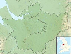
Location of the mouth within Cheshire
Location
Country England
County Cheshire
District Cheshire West and Chester
Physical characteristics
Source 
  locationnear Peckforton
  coordinates 53°05′56″N2°41′02″W / 53.0988°N 2.6838°W / 53.0988; -2.6838
Mouth  
  location
confluence with River Mersey, Stanlow Refinery
  coordinates
53°17′29″N2°51′08″W / 53.2914°N 2.8521°W / 53.2914; -2.8521
Length32 km (20 mi)

The River Gowy is a river in Cheshire, England, a tributary of the River Mersey.

It rises in western Cheshire in the hills near Peckforton Castle, very close to the source of the River Weaver. While the Weaver flows south initially, the Gowy flows north and for several miles provides the valley used by the Shropshire Union Canal. It runs just to the east of Chester and passes through a syphon under the Manchester Ship Canal to meet the Mersey near Stanlow. Its total length is around 20 miles (32 km).

Perennially popular with fishermen and home to several rare invertebrates, [1] it has been polluted in its lower reaches in recent decades, due in part to the oil refinery at Stanlow and the arrival of the nearby M53 and M56 motorways, leading to schemes by environmental groups to clean up the area and to restock the fish population.

One of the 'Roman' bridges at Hockenhull Platts Roman Bridge.jpg
One of the 'Roman' bridges at Hockenhull Platts

The Gowy Meadows Nature Reserve, founded in 2002 [2] and stretching from the A5117 to the M56, is an area of river valley peat covered with wet grassland or grazing meadows. This area of 160 hectares (395 acres), owned by Shell UK, has been created as a nature reserve by Cheshire Wildlife Trust. Surveys by the Environment Agency show that the Gowy's eel population has held up well despite a Europe-wide massive decline in numbers. The reasons for this are unclear but local anglers suggest that eel in the river may not follow normal migration patterns because of the partially closed nature of the river flow caused by the system of syphoning under the ship canal.

At one time the river provided power for up to 20 watermills. Today only a few remain: Bates Mill and Walk Mill (both in private ownership), Bunbury Mill (now owned by a Trust) and Trafford Mill. The latter is owned by United Utilities plc. Bunbury Mill is open to the public at times. Trafford Mill is being developed as a museum and an educational and training resource concentrating on conservation-related activities.

The river's length has been increased over the centuries as land has been reclaimed by draining the marshes. It was on the marshes at Gibbet’s Field near Mickle Trafford that James Brown and Thomas Price were hanged in January 1795 for the abduction and robbery of a mail boy.

Tributaries

Related Research Articles

<span class="mw-page-title-main">River Mersey</span> Major river emptying into Liverpool Bay

The River Mersey is a major river in North West England. Its name derives from Old English and means "boundary river", possibly referring to its having been a border between the ancient kingdoms of Mercia and Northumbria. For centuries it has formed part of the boundary between the historic counties of Lancashire and Cheshire.

<span class="mw-page-title-main">River Dane</span> River in England

The River Dane is a tributary of the River Weaver that originates in the Peak District area of England. The name of the river is probably from the Old Welsh dafn, meaning a "drop or trickle", implying a slow-moving river.

<span class="mw-page-title-main">River Weaver</span> River in Cheshire, England

The River Weaver is a river, navigable in its lower reaches, running in a curving route anti-clockwise across west Cheshire, northern England. Improvements to the river to make it navigable were authorised in 1720 and the work, which included eleven locks, was completed in 1732. An unusual clause in the enabling Act of Parliament stipulated that profits should be given to the County of Cheshire for the improvement of roads and bridges, but the navigation was not initially profitable, and it was 1775 before the first payments were made. Trade continued to rise, and by 1845, over £500,000 had been given to the county.

<span class="mw-page-title-main">A49 road</span> Road in England

The A49 is an A road in western England, which traverses the Welsh Marches region. It runs north from Ross-on-Wye in Herefordshire via Hereford, Leominster, Ludlow, Shrewsbury and Whitchurch, then continues through central Cheshire to Warrington and Wigan before terminating at its junction with the A6 road just south of Bamber Bridge, near the junction of the M6, M65 and M61 motorways.

The Cheshire Wildlife Trust (CWT) is a wildlife trust covering the county of Cheshire and parts of the counties of Greater Manchester and Merseyside, England. The trust's chairman is Bill Stothart. It manages 43 nature reserves totalling over 470 hectares, including:

<span class="mw-page-title-main">Elton, Cheshire</span> Human settlement in England

Elton is a village and civil parish in Cheshire West and Chester, Cheshire, England, 13 km (8.1 mi) northeast of Chester, between Helsby and Ellesmere Port, near the River Mersey. Its proximity to the Mersey and the Manchester Ship Canal have contributed to its industrial character. The village is on the north-western edge of the Cheshire Plain, 2.5 km (1.6 mi) from Stanlow Refinery.

<span class="mw-page-title-main">Ince, Cheshire</span> Human settlement in England

Ince is a village and civil parish in the unitary authority of Cheshire West and Chester and the ceremonial county of Cheshire, England. It is situated immediately to the east of the Stanlow Oil Refinery. It shares Ince & Elton railway station with the village of Elton, which it runs into.

<span class="mw-page-title-main">Blakenhall, Cheshire</span> Human settlement in England

Blakenhall is a small village and former civil parish, now in the parish of Doddington and District, in the unitary authority area of Cheshire East and the ceremonial county of Cheshire, England, about 7 miles (11 km) south-east of Nantwich. It lies on the county boundary with Staffordshire. The parish has an area of 654 hectares and also includes the small settlements of The Den and Gonsley Green, with a total population of 125 in 2001. Nearby villages include Wybunbury in Cheshire and Betley and Wrinehill in Staffordshire. Blakenhall was first recorded in the Domesday survey as Blachenhale, and the parish had one of Cheshire's early ironworks in the 17th and 18th centuries. The area is rural and predominantly agricultural, with small areas of ancient woodland and the nature reserve of Blakenhall Moss, a rejuvenating lowland raised bog. The Crewe-to-Stafford railway line runs through the parish and it is on the proposed route of HS2.

<span class="mw-page-title-main">River Penk</span> River in Staffordshire, England

The River Penk is a small river flowing through Staffordshire, England. Its course is mainly within South Staffordshire, and it drains most of the northern part of that district, together with some adjoining areas of Cannock Chase, Stafford, Wolverhampton, and Shropshire. It flows into the River Sow, which is a tributary of the River Trent, so its waters flow ultimately into the North Sea via the Humber Estuary.

<span class="mw-page-title-main">Sale Water Park</span> Public park in Sale Moor, Greater Manchester

Sale Water Park is a 152-acre (62 ha) area of parkland including a 52-acre (21 ha) artificial lake in the Metropolitan Borough of Trafford in Greater Manchester, England. Opened in 1979 and owned by Trafford Council, the water park lies in an area of the green belt running through the Mersey river valley between Sale and Stretford, located between the river and the M60 motorway. The lake was formed in the 1970s by the flooding of a gravel pit excavated to provide material for the construction of an embankment raising the motorway 34 feet (10 m) above the Mersey's floodplain. The pit was excavated to a depth of around 115 feet (35 m), making the lake about 90 feet (27 m) deep in places.

The Abbey of St. Mary at Stanlaw, was a Cistercian foundation situated on Stanlaw - now Stanlow Point, on the banks of the River Mersey in the Wirral Peninsula, Cheshire, England, near Ellesmere Port, 11 km north of Chester Castle and 12 km south-west of Halton Castle.

<span class="mw-page-title-main">A5117 road</span> Road in England

The A5117 is a road in Cheshire, England. It runs between Shotwick (53.2374°N 2.9875°W) and Helsby (53.2613°N 2.7814°W) and connects the A550 at Woodbank to the M56. As such it forms a northerly bypass to Chester and a shorter route between the North West and North Wales than the A55.

<span class="mw-page-title-main">Cheshire West and Chester</span> Borough in England

Cheshire West and Chester is a unitary authority area with borough status in Cheshire, England. It was established on 1 April 2009 as part of the 2009 local government changes, by virtue of an order under the Local Government and Public Involvement in Health Act 2007. It superseded the boroughs of Ellesmere Port and Neston, Vale Royal and the City of Chester; its council assumed the functions and responsibilities of the former Cheshire County Council within its area. The remainder of ceremonial Cheshire is composed of Cheshire East, Halton and Warrington. Cheshire West and Chester has three key urban areas: Chester, Ellesmere Port and Northwich/Winsford.

This is a list of places of interest in Cheshire, England. See List of places in Cheshire for a list of settlements in the county.

<span class="mw-page-title-main">Hockenhull Platts</span>

The Hockenhull Platts are three bridges southwest of the village of Tarvin, Cheshire, England. They are also known as the "Packhorse Bridges" or (erroneously) the "Roman Bridges", and are recorded in the National Heritage List for England as designated Grade II listed buildings. The bridges are situated where Platts Lane crosses the River Gowy. An area of 5 hectares west of the Gowy, including the westernmost bridge, forms Hockenhull Platts Nature Reserve, managed by the Cheshire Wildlife Trust.

<span class="mw-page-title-main">Gowy Meadows Nature Reserve</span>

Gowy Meadows Nature Reserve is a 165.8-hectare (410-acre) nature reserve near Ellesmere Port, Cheshire, England. It consists of low-lying meadows immediately to the east of the River Gowy near its confluence with the River Mersey, south of Stanlow Oil Refinery and west of the village of Thornton-le-Moors. It is managed by the Cheshire Wildlife Trust on behalf of the landowner, Shell UK, and was founded in 2002. The M56 motorway runs along the southern edge of the reserve.

<span class="mw-page-title-main">Dutton Park Farm Nature Reserve</span>

Dutton Park Farm Nature Reserve is an 18-hectare (44-acre) nature reserve northwest of Weaverham, Cheshire, England. It is managed by the Cheshire Wildlife Trust.

<span class="mw-page-title-main">Mount Manisty</span>

Mount Manisty is a large man-made hillock, uninhabited and located between the Manchester Ship Canal and the River Mersey 1.5 miles (2.4 km) northwest of Ellesmere Port in Cheshire, England. The mound, which is 100 feet (30 m) tall, was created from earth excavated during the building of the ship canal between Eastham and Ellesmere Port in the late 19th century. The feature forms a narrow elevated stretch of land between the canal and the river.

<span class="mw-page-title-main">North Cheshire Way</span> Long-distance footpath in Cheshire, England

The North Cheshire Way is a 71-mile (114 km) long-distance footpath in Cheshire, England. It runs approximately eastwards from Hooton railway station on the Wirral peninsula to Disley railway station on the edge of the Peak District, where it connects with the Gritstone Trail. There is a 6-mile (9.7 km) spur from Chester to Croughton.

References

  1. "Gowy Meadows Management Plan 2010-2020". Cheshire Wildlife Trust. Retrieved 31 July 2012.
  2. Askeland, Erikka (June 2004). "Otters, Orchids and Oil" (PDF). Source NW. Mersey Basin Campaign. p. 21. Retrieved 13 July 2018.