
The A41 is a trunk road between London and Birkenhead, England. Now in parts replaced by motorways, it passes through or near Watford, Kings Langley, Hemel Hempstead, Aylesbury, Bicester, Solihull, Birmingham, West Bromwich, Wolverhampton, Newport, Whitchurch, Chester and Ellesmere Port.
The A1, also known as the Great North Road, is the longest numbered road in the United Kingdom, at 410 miles (660 km). It connects London, the capital of England, with Edinburgh, the capital of Scotland. The numbering system for A-roads, devised in the early 1920s, was based around patterns of roads radiating from two hubs at London and Edinburgh. The first number in the system, A1, was given to the most important part of that system: the road from London to Edinburgh, joining the two central points of the system and linking the UK's (then) two mainland capital cities. It passes through or near north London, Hatfield, Welwyn Garden City, Stevenage, Baldock, Letchworth Garden City, Biggleswade, Eaton Socon, Buckden, Peterborough, Stamford, Grantham, Newark-on-Trent, Retford, Doncaster, Pontefract, York, Wetherby, Ripon, Darlington, Durham, Gateshead, Newcastle upon Tyne, Morpeth, Alnwick and Berwick-upon-Tweed.

The M40 motorway links London, Oxford, and Birmingham in England, a distance of approximately 89 miles (143 km).

The M67 is a 5-mile (8.0 km) urban motorway in Greater Manchester, England, which heads east from the M60 motorway passing through Denton and Hyde before ending near Mottram. The road was originally conceived as the first section of a trans-Pennine motorway between Manchester and Sheffield that would connect the A57(M) motorway with the M1 motorway; however, the motorway became the only part to be built.

The A6 is one of the main north–south roads in England. It runs from Luton in Bedfordshire to Carlisle in Cumbria, although it formerly started at a junction with the A1 at Barnet. It is the fourth longest numbered road in Britain; only the A1, A38 and A30 are longer.

The M20 is a motorway in Kent, England. It follows on from the A20 at Swanley, meeting the M25, and continuing on to Folkestone, providing a link to the Channel Tunnel and the ports at Dover. It is 50.6 miles (81.4 km) long. Although not signposted in England, this road is part of the European route E15. It is also used as a holding area for goods traffic when traffic across the English Channel is disrupted, such as Operation Stack and Operation Brock.

The M56 motorway serves the Cheshire and Greater Manchester areas of England. It runs east to west from junction 4 of the M60 at Gatley, south of Manchester, to Dunkirk, approximately four miles north of Chester. With a length of 33.3 miles (53.6 km), it connects North Wales and the Wirral peninsula with much of the rest of North West England, serves business and commuter traffic heading towards Manchester, particularly that from the wider Cheshire area, and provides the main road access to Manchester Airport from the national motorway network.

The M53 is an 18.9-mile (30.4 km) motorway in the Metropolitan Borough of Wirral, Merseyside and the borough of Cheshire West and Chester, Cheshire on the Wirral Peninsula in England. It is also referred to as the Mid Wirral Motorway. It runs between the Kingsway Tunnel, at Wallasey in the north, and the A55 at Chester.

The A6144(M) was a motorway in Carrington, Greater Manchester, England. It was known in official documentation as the Carrington Spur Road and built to facilitate the transport of hazardous goods from Shell Chemicals' ethylene oxide plant in Carrington and other industrial estates in Carrington and Broadheath. It was extremely unusual in that it was entirely single carriageway, the only motorway of its kind in the UK as others were dual carriageway for at least some of their length.

The A49 is an A road in western England, which traverses the Welsh Marches region. It runs north from Ross-on-Wye in Herefordshire via Hereford, Leominster, Ludlow, Shrewsbury and Whitchurch, then continues through central Cheshire to Warrington and Wigan before terminating at its junction with the A6 road just south of Bamber Bridge, near the junction of the M6, M65 and M61 motorways.

The A55, also known as the North Wales Expressway, is a major road in Wales and England, connecting Cheshire and North Wales. The vast majority of its length from Chester to Holyhead is a dual carriageway primary route, with the exception of the Britannia Bridge over the Menai Strait and several short sections where there are gaps in between the two carriageways. All junctions are grade separated apart from a roundabout east of Penmaenmawr and another nearby in Llanfairfechan. Initially, the road ran from Chester to Bangor. In 2001, it was extended across Anglesey to the ferry port of Holyhead parallel to the A5. The road improvements have been part funded with European money, under the Trans-European Networks programme, as the route is designated part of Euroroute E22.

The M50 is a motorway in Worcestershire, Gloucestershire, and Herefordshire, England. Sometimes referred to as the Ross Spur, it is a 22 miles (35 km) connection of the M5 motorway M42 Motorway to a point near Ross-on-Wye, where it joins the A40 road continuing westward into Wales. The motorway was fully opened in 1962.
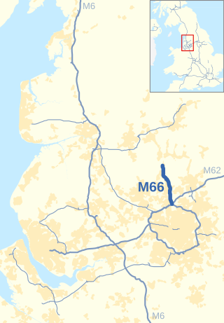
The M66, also known as the Bury Easterly Bypass, is a motorway in Lancashire and Greater Manchester, England. It is 8 miles (13 km) long and provides part of the route between the M62 and M60 motorways and the M65, with the rest being provided by the A56.
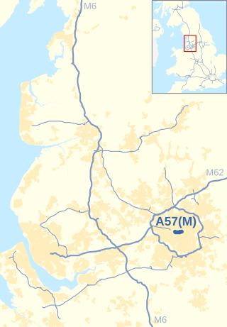
The Mancunian Way is a two mile long grade separated elevated motorway in Manchester, England. It is officially made up of the A57(M) and A635(M) motorways, although the latter does not appear on road signs for practical reasons. It is also part of two other roads: the A57 to the west, which runs east–west through Greater Manchester linking the M602 and M67 motorways, and a short section of non-motorway A635 to the east. Part of this non-motorway section collapsed on 14 August 2015 due to a sinkhole.

The A54 road is a road in England linking Chester in Cheshire with Buxton in Derbyshire. Its route through both urban and steep rural areas presents a challenge to Cheshire County Council in maintaining the safety of the road. Many years ago it was the main east–west route in Cheshire. The importance of the A54 through Middlewich and Winsford decreased in the 1970s and 1980s with the building of the M56 motorway and dualling of the A556 at Northwich. The section through Winsford carries approximately 30,000 vehicles per day.
The A56 is a road in England which extends between the city of Chester in Cheshire and the village of Broughton in North Yorkshire. The road contains a mixture of single and dual carriageway sections, and traverses environments as diverse as the dense urban sprawl of inner city Manchester and the lightly populated region of rural east Lancashire. The road includes a short section of trunk road between the end of the M66 motorway near Ramsbottom and the M65 motorway west of Burnley.
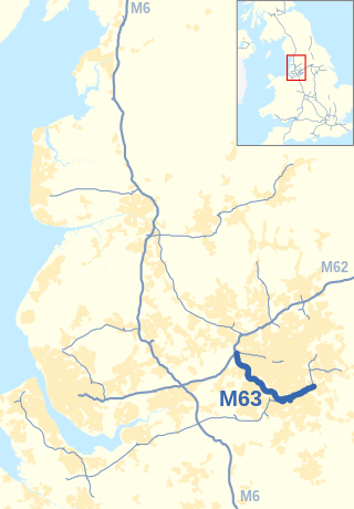
The M63 motorway was a major road in the United Kingdom. It was completely renumbered, in 1998, to become a substantial part of the M60 motorway which orbits part of Greater Manchester.

The A525 is a major route from Rhyl in Wales to Newcastle-under-Lyme in England. The route passes near Denbigh, through Ruthin, through Wrexham and near Whitchurch.

Chester services is a motorway service area on the M56 motorway in Cheshire, England. The site is approximately 10 mi (16 km) from Chester city centre. Operated by Roadchef, it is the only motorway service area on the M56 and the last before heading into North Wales.

The A556 is a road in England which extends from the village of Delamere in Cheshire West and Chester to the Bowdon Interchange in Cheshire East, bordering Greater Manchester. The road contains a mixture of single and dual carriageway sections and forms a large part of the route between Manchester and Chester. It also acts as a major access route to Chester/North Wales to the west and to Manchester to the east for the conurbation of towns and villages around the Dane Valley centering on Winsford and Northwich. The central part, which forms the Northwich Bypass between Davenham and Lostock Gralam, suffers because of the amount of commuter traffic from this area. The part of the route between the M6 motorway Junction 19 and the M56 motorway Junction 7 is a major route into Manchester and has been recently upgraded to a four-lane dual carriageway.
