The Lake District, also known as the Lakes or Lakeland, is a mountainous region and national park in North West England. It is primarily famous for its mountain, lake, and coastal scenery, and for its literary associations with William Wordsworth and other Lake Poets, Beatrix Potter, and John Ruskin.
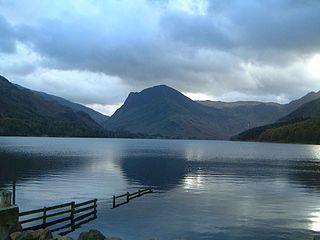
Buttermere is a lake in the Lake District in North West England. It has a length of approximately 2 kilometres (1.2 mi) and a maximum width of 0.54 kilometres (0.34 mi), an area of 0.9 square kilometres (0.35 sq mi), a maximum depth of 28.6 metres (94 ft), and a surface elevation of 100.3 metres (329 ft) above sea level. Its primary outflow is Buttermere Dubs, a short stream which connects the lake to Crummock Water. From Crummock Water the River Cocker flows to Cockermouth, where it joins the River Derwent and finally enters the Irish Sea at Workington. The lake is in the unitary authority of Cumberland, and the ceremonial county of Cumbria.

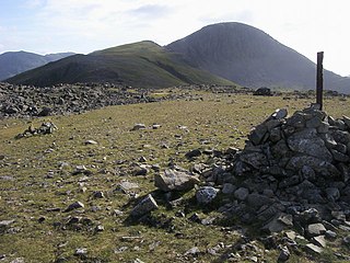
Robinson is a fell in the English Lake District, its southern slopes descending to Buttermere, while its northern side is set in the Newlands Valley. Paths lead to the summit from the village of Buttermere, from the nearby summit Dale Head and from various locations in the valleys to the north.

Borrowdale is a valley and civil parish in the English Lake District in Cumberland, England. It is in the ceremonial county of Cumbria, and is sometimes referred to as Cumberland Borrowdale to distinguish it from another Borrowdale in the historic county of Westmorland.
Haystacks, or Hay Stacks, is a hill in England's Lake District, situated at the south-eastern end of the Buttermere Valley. Although not of any great elevation, Haystacks has become one of the most popular fells in the area. This fame is partly due to the writings of Alfred Wainwright, who espoused its attractions and chose it as the place where he wanted his ashes scattered. Its large, undulating summit contains many rock formations, tarns and hidden recesses.
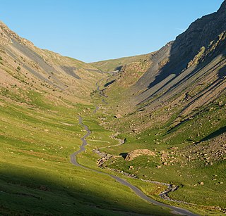
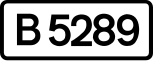
Honister Pass is a mountain pass in the Lake District in Cumbria, England. It is located on the B5289 road, linking Seatoller, in the valley of Borrowdale, to Gatesgarth at the southern end of Buttermere. The pass reaches an altitude of 1,167 feet (356 m), making it one of the highest in the region, and also one of the steepest, with gradients of up to 1-in-4 (25%). The saddle at the watershed is known as Honister Hause, using the Cumbrian word hause for such a feature.

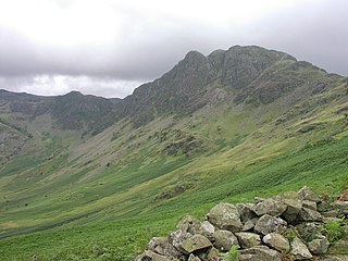
Fleetwith Pike is a fell in the English Lake District in the county of Cumbria which reaches a height of 648 metres. The fell is a well-known feature of the area as it casts an imposing presence over Buttermere and the Honister Pass on the B5289 motor road between Borrowdale and Buttermere.

Rannerdale Knotts is a fell in the Lake District of Cumbria, England. Rising from the Buttermere valley, it is one of the smaller Cumbrian hills and is overlooked by a number of surrounding fells, such as Grasmoor, Whiteless Pike and, across Crummock Water, Mellbreak and the High Stile ridge. Rannerdale Knotts is said to be the site of a battle between the native Cumbrians and Norsemen and the invading Normans in the late 11th or early 12th century.

The Newlands Valley is in the Lake District National Park in Cumbria, England. It is regarded as one of the most picturesque and quiet valleys in the national park, even though it is situated very close to the popular tourist town of Keswick and the busy A66 road.

Glaramara is a fell in the English Lake District in Cumbria. It is a substantial fell that is part of a long ridge that stretches for over six kilometres from Stonethwaite in Borrowdale up to the important mountain pass of Esk Hause. The summit of Glaramara at 783 metres (2,569 ft) is the central point of this ridge, which separates the valleys of Langstrath and Grains Gill. However, the ridge has two additional fells, numerous subsidiary tops and several small tarns making its traverse an appealing and challenging walk.

Grey Knotts is a fell in the English Lake District. It is situated one kilometre south of the B5289 road as it crosses the Honister Pass. It is well seen from mid-Borrowdale as it rises above Seatoller. Grey Knotts reaches a height of 697 metres and is part of a ridge which ascends from the woodland behind Seatoller and continues south-west and then south for four kilometres to Great Gable. The fell's name really only applies to the summit rocks, but has been adopted for the entire fell with the high ground in this area, locally known as Seatoller Fell on Ordnance Survey maps.

Sail is a hill in the English Lake District, lying between Derwentwater and Crummock Water.

The Whinlatter Pass is a mountain pass in the Lake District in Cumbria, England. It is located on the B5292 road linking Braithwaite, to the west of Keswick, with High Lorton to the south of Cockermouth.
Brandreth is a fell in the English Lake District. It stands between Great Gable and Haystacks in the Western Fells.
Honister Crag SSSI is a Site of Special Scientific Interest in Cumbria, England. It is designated for both biological and geological interest. The site covers an area of 302.9 ha on Honister Crag, from which it takes its name, and Fleetwith Pike, an adjacent fell.

The North Western Fells are a part of the Cumbrian Mountains in the Lake District of England. Including such favourites as Catbells and Grisedale Pike, they occupy an oval area beneath the Buttermere and Borrowdale valley systems. The North Western Fells are characterised by soaring east-west ridges and an absence of mountain tarns.

Seathwaite is a small hamlet in the Borrowdale civil parish of Cumberland, Cumbria, North West England. It is in the Lake District near Scafell Pike and 8 miles (13 km) southwest of Keswick at the end of a minor road that heads southwest from the hamlet of Seatoller, which is where the B5289 road begins its steep climb up the pass to Honister Hause on the boundary between Borrowdale civil parish and Buttermere civil parish.
Buttermere is a village and civil parish in the county of Cumbria, England.

Gatesgarth is a settlement in Lake District of England. It is situated to the east of the lake of Buttermere, on the B5289 road on its western approach to the Honister Pass.

Seatoller is a settlement in Borrowdale in the English Lake District. Historically part of Cumberland, it lies on the B5289 road at the east foot of the Honister Pass, and to the south of Derwent Water. The nearest town to Seatoller is Keswick, which is situated approximately 7 miles (11 km) to the north.