Buttermere, Cumbria (village)

Last updated

Buttermere
Grasmoor.jpg
Buttermere village (centre), with Grasmoor (above), Buttermere lake (below), and Crummock Water (left).
Location map United Kingdom Allerdale.svg
Red pog.svg
Buttermere
Location in Allerdale, Cumbria
Cumbria UK location map.svg
Red pog.svg
Buttermere
Location within Cumbria
Population121 (2011)
OS grid reference NY174170
Civil parish
  • Buttermere
Unitary authority
Ceremonial county
Region
Country England
Sovereign state United Kingdom
Post town COCKERMOUTH
Postcode district CA13
Dialling code 017687
Police Cumbria
Fire Cumbria
Ambulance North West
UK Parliament
List of places
UK
England
Cumbria
54°32′30″N3°16′32″W / 54.541543°N 3.275625°W / 54.541543; -3.275625 Coordinates: 54°32′30″N3°16′32″W / 54.541543°N 3.275625°W / 54.541543; -3.275625

Buttermere is a village and civil parish in the county of Cumbria, England.

Contents

Village

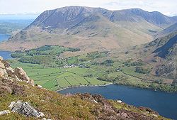
The village of Buttermere lies between the Lake District lakes of Buttermere and Crummock Water, and is overlooked by the summits of Grasmoor to the north and High Stile to the south. The nearest towns are Keswick and Cockermouth, both of which are approximately 10 miles (16 km) away. [1]

Plaque to Alfred Wainwright in Buttermere Church AW's Memorial Window Tablet in St James' Church, Buttermere. - geograph.org.uk - 1307454.jpg
Plaque to Alfred Wainwright in Buttermere Church

Buttermere church is dedicated to St James, and dates from 1840, replacing a chapel which was dedicated in 1507. It has a memorial plaque to Alfred Wainwright, in the sill of a window with a view of Haystacks where his ashes were scattered. [2] It is grade II listed. [3]

In the village, The Bridge Hotel, stands on a site tracing back to the 11th century, where an armoury and a bakery stood, in connection with the Water-Mill Earl Boether built higher up the stream. For seven centuries the mill worked continuously, the buildings being many times renewed. Circa 1734, the buildings were sold to the church, the curate being the Reverend Robert Walker. He obtained a beer licence and originated the 'Bridge Inn'. In 1837, Jonathan Thomas Sleap purchased the property, rebuilding the inn using stone obtained from the old water will. He changed the name to 'Victoria' upon the visit by Her Majesty in 1850. In 1861, Mrs H Cooper inherited the property incorporating the bay windows, but it was the author Nicholas Size, who in 1920 extended and improved the building. Upon his death the new owner changed the name to 'The Bridge'.[ citation needed ] Peter and Janet McGuire who bought the hotel 1978, have owned the premises to the present day.[ citation needed ]

The Fish Inn was the home of Mary Robinson, known as the Maid of Buttermere, when her father was its landlord. It kept this name until 2019 [4] and is now called the Buttermere Court Hotel. [5]

Buttermere is situated on the B5289 road that runs beside Crummock Water and along the valley of the River Cocker north to Cockermouth. In the other direction, the B5289 runs via the steep Honister Pass, to Borrowdale and Keswick. A more direct, but more minor, road crosses the nearby Newlands Pass into the Newlands Valley and hence to Keswick.[ citation needed ]

Civil parish

The civil parish of Buttermere covers a considerable area around the village, including both Buttermere and Crummock Water lakes, the summit of Grasmoor, the north side of High Stile and the western side of Honister Pass. The smaller settlements of Brackenthwaite, to the north of Crummock Water, and Gatesgarth, at the foot of the Honister Pass, are included. The parish lies entirely within the Lake District National Park. At the time of the 2001 census the parish had a population of 127 living in 49 households, [6] [7] falling slightly at the 2011 Census to a population of 121 in 45 households. [8]

For Local Government purposes it's in the Cumberland unitary authority area.

The civil parish previusly formed part of the district of Allerdale within the county of Cumbria.

Historically part of Cumberland, it is within the Workington constituency of the United Kingdom Parliament. Prior to Brexit in 2020 it was part of the North West England constituency of the European Parliament. [6]

Transport

A free bus operates between Buttermere and Cockermouth with five return services per day. [9]

Famous residents

See also

Related Research Articles

<span class="mw-page-title-main">Keswick, Cumbria</span> Town in the Lake District, England

Keswick is a market town and civil parish in Cumbria, England. Historically, until 1974, it was part of Cumberland. It lies within the Lake District National Park, Keswick is just north of Derwentwater and is four miles from Bassenthwaite Lake. It had a population of 5,243 at the 2011 census.

<span class="mw-page-title-main">Allerdale</span> Former non-metropolitan district in England

Allerdale was a non-metropolitan district of Cumbria, England, with borough status. Its council was based in Workington and the borough has a population of 93,492 according to the 2001 census, increasing to 96,422 at the 2011 Census.

<span class="mw-page-title-main">Buttermere</span> Body of water

Buttermere is a lake in the Lake District in North West England. It has a length of approximately 2 kilometres (1.2 mi) and a maximum width of 0.54 kilometres (0.34 mi), an area of 0.9 square kilometres (0.35 sq mi), a maximum depth of 28.6 metres (94 ft), and a surface elevation of 100.3 metres (329 ft) above sea level. Its primary outflow is Buttermere Dubs, a short stream which connects the lake to Crummock Water. From Crummock Water the River Cocker flows to Cockermouth, where it joins the River Derwent and finally enters the Irish Sea at Workington. The lake is in the administrative county of Cumberland, and the ceremonial county of Cumbria.

<span class="mw-page-title-main">Borrowdale</span> Human settlement in England

Borrowdale is a valley and civil parish in the English Lake District in Cumberland, England. It is in the ceremonial county of Cumbria, and is sometimes referred to as Cumberland Borrowdale to distinguish it from another Borrowdale in the historic county of Westmorland.

<span class="mw-page-title-main">B5289 road</span> Road in the Lake District, England

The B5289 is a road in the Lake District, England. It lies in the county of Cumbria, and is an important traffic artery in the Lake District.

<span class="mw-page-title-main">Honister Pass</span> Mountain pass in the English Lake District, Cumbria, England

Honister Pass is a mountain pass in the English Lake District. It is located on the B5289 road, linking Seatoller, in the valley of Borrowdale, to Gatesgarth at the southern end of Buttermere. The pass reaches an altitude of 1,167 feet (356 m), making it one of the highest in the region, and also one of the steepest, with gradients of up to 1-in-4 (25%). The saddle at the watershed is known as Honister Hause, using the Cumbrian word hause for such a feature.

<span class="mw-page-title-main">Lorton, Cumbria</span> Pair of villages in Cumbria, England

Lorton, a parish in Cumberland, Cumbria, England, consists of two adjacent villages: Low Lorton and High Lorton. Both nestle at the northern end of the Vale of Lorton, surrounded by fells such as Grasmoor, Hopegill Head and Whiteside. They are about 4 miles (6.5 km) from Cockermouth, which gives access to the main A66 road. Other nearby places include Loweswater and Brigham.

<span class="mw-page-title-main">Crummock Water</span> Body of water

Crummock Water is a lake in the Lake District in North West England. It is 2.5 miles (4.0 km) long, 0.6 miles (0.97 km) wide, 140 feet (43 m) deep, and has an area of 2.5 square kilometres (0.97 sq mi). The lake's primary inflow is Buttermere Dubs, itself the outflow of Buttermere, and its outflow is the River Cocker, which meets the River Derwent at Cockermouth before entering the Irish Sea at Workington. It is in the administrative county of Cumberland and the ceremonial county of Cumbria. It is in the parish of Buttermere, and its western shore forms part of the western boundary of the parish.

<span class="mw-page-title-main">Fleetwith Pike</span>

Fleetwith Pike is a fell in the English Lake District in the county of Cumbria which reaches a height of 648 metres. The fell is a well-known feature of the area as it casts an imposing presence over Buttermere and the Honister Pass on the B5289 motor road between Borrowdale and Buttermere.

<span class="mw-page-title-main">Rannerdale Knotts</span>

Rannerdale Knotts is a fell in the Lake District of Cumbria, England. Rising from the Buttermere valley, it is one of the smaller Cumbrian hills and is overlooked by a number of surrounding fells, such as Grasmoor, Whiteless Pike and, across Crummock Water, Mellbreak and the High Stile ridge. Rannerdale Knotts is said to be the site of a battle between the native Cumbrians and Norsemen and the invading Normans in the late 11th or early 12th century.

<span class="mw-page-title-main">Wandope</span> Fell in the Lake District, Cumbria, England

Wandope is a fell in the north-western area of the English Lake District. It lies to the east of Crummock Water and south of Crag Hill. From the summit there are excellent panoramas of the Sca Fell and High Stile ranges.

<span class="mw-page-title-main">Whinlatter Pass</span>

The Whinlatter Pass is a mountain pass in the English Lake District. It is located on the B5292 road linking Braithwaite, to the west of Keswick, with High Lorton to the south of Cockermouth.

<span class="mw-page-title-main">Dearham</span> Village in Cumbria, England

Dearham is a village and civil parish in Cumbria, historically part of Cumberland, near the Lake District National Park in England. It lies about 2 miles (3.2 km) east of Maryport and 5 miles (8.0 km) west of Cockermouth.

<span class="mw-page-title-main">North Western Fells</span>

The North Western Fells are a group of hills in the English Lake District. Including such favourites as Catbells and Grisedale Pike, they occupy an oval area beneath the Buttermere and Borrowdale valley systems. The North Western Fells are characterised by soaring east-west ridges and an absence of mountain tarns.

<span class="mw-page-title-main">Rosthwaite, Allerdale</span> Human settlement in England

Rosthwaite is a settlement in the Allerdale borough of Cumbria, England. It is also in Borrowdale in the English Lake District. It lies on the B5289 road to the south of Derwent Water and to the east of the Honister Pass in the county of Cumbria.

<span class="mw-page-title-main">Grange in Borrowdale</span> Human settlement in England

Grange, often called Grange in Borrowdale, is a village in Borrowdale in the English Lake District. It lies just off the B5289 road to the south of Derwent Water and 4 miles (6.4 km) south of Keswick, in the county of Cumbria, historically part of Cumberland,

<span class="mw-page-title-main">Seatoller</span> Village in England

Seatoller is a settlement in Borrowdale in the English Lake District. Historically part of Cumberland, it lies on the B5289 road at the east foot of the Honister Pass, and to the south of Derwent Water. The nearest town to Seatoller is Keswick, which is situated approximately 7 miles (11 km) to the north.

<span class="mw-page-title-main">Newlands Pass</span>

The Newlands Pass, also known as Newlands Hause, is a mountain pass in the English Lake District. It is located on an unclassified road linking the Newlands Valley, to the west of Keswick and Derwent Water, with the village of Buttermere. The highest point on the pass is at an altitude of 1,093 feet (333 m), and it has gradients of 1 in 4 on both sides.

<span class="mw-page-title-main">Loweswater (village)</span> Human settlement in England

Loweswater is a village and civil parish in the county of Cumbria, England.

<span class="mw-page-title-main">Braithwaite</span> Village in Cumbria, England

Braithwaite is a village in the northern Lake District, in Cumbria, England. Historically in Cumberland, it lies just to the west of Keswick and to the east of the Grisedale Pike ridge. It forms part of the civil parish of Above Derwent.

References

  1. "Buttermere, Cumbria, The Lake District". The Cumbria Directory. Retrieved 13 January 2010.
  2. "Buttermere St James' Church". Visit Cumbria. Retrieved 19 August 2020.
  3. Historic England. "Church of St James (1144520)". National Heritage List for England . Retrieved 19 August 2020.
  4. "Fish Inn sold for £1.35m". News and Star. Retrieved 19 August 2020.
  5. "Buttermere Court Hotel, Buttermere" . Retrieved 19 August 2020.
  6. 1 2 "Election Maps". Ordnance Survey. Retrieved 2 January 2010.
  7. "Census 2001 : Parish Headcounts : Allerdale". Office for National Statistics. Archived from the original on 13 June 2011. Retrieved 22 November 2009.
  8. UK Census (2011). "Local Area Report – Buttermere parish (E04002398)". Nomis. Office for National Statistics.
  9. "Free bus service launches between Cockermouth and Buttermere". Cumbria Crack. 19 July 2021. Archived from the original on 19 July 2021. Retrieved 20 July 2021.

Commons-logo.svg Media related to Buttermere, Cumbria (village) at Wikimedia Commons