WikiMili
List of places in Cumbria
Last updated
June 02, 2025
This is a
list of cities, towns and villages in the county of
Cumbria
,
England
.
Contents
A
B
C
D
E
F
G
H
I-J
K
L
M
N
O
P
Q
R
S
T
U
V
W
Y
See also
Contents
:
A
B
C
D
E
F
G
H
I
J
K
L
M
N
O
P
Q
R
S
T
U
V
W
X
Y
Z
See also
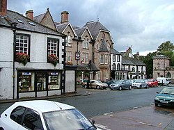
Appleby Market Square
Central Barrow-in-Furness skyline
Bassenthwaite Lake
Bewcastle Cross
Black Combe cairn
Borrowdale
Buttermere
Carlisle Castle
Conishead Priory
near Ulverston
Coniston
Dungeon Ghyll
Ennerdale Water
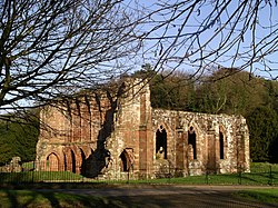
Furness Abbey
Grizedale Tarn
Kendal, canal
change bridge
Keswick, Moot Hall
Patterdale village
Silloth, West Beach
Silloth Port
River Nith
estuary
Wasdale from Wastwater
Walney Island
Whitehaven beacon
Whitehaven
Whitehaven Maritime Festival 2005
Windermere
A
Abbeytown
,
Ackenthwaite
,
Adgarley
,
Aglionby
Aiketgate
,
Aikhead
,
Aikshaw
,
Aikton
,
Ainstable
,
Aisgill
Albyfield
,
Aldingham
,
Aldoth
,
Allenwood
Allhallows
,
Allithwaite
,
Allonby
Alston
,
Alston Moor
Ambleside
Angerton, Cumberland
,
Angerton, Westmorland and Furness
,
Annaside
,
Anthorn
Appleby-in-Westmorland
,
Applethwaite
Arkleby
,
Arlecdon
,
Armaside
,
Armathwaite
Arnaby
,
Arnside
,
Arrad Foot
,
Arthuret
,
Asby, Cumberland
,
Asby, Westmorland and Furness
Ashgill
,
Askam-in-Furness
,
Askham
,
Askerton
Aspatria
,
Aughertree
,
Ayside
B
Backbarrow
,
Baggrow
,
Baldwinholme
,
Bampton
,
Bampton Grange
Bandrake Head
,
Banks
,
Barber Green
,
Barbon
Barclose
,
Bardsea
,
Barepot
,
Barras
Barrow Island
,
Barrow-in-Furness
Barrows Green
,
Barton
Bassenthwaite
Baycliff
,
Bayles
,
Beanthwaite
,
Beaumont
Beck Bottom
,
Beck Foot
,
Beck Head
,
Beck Side
Beckces
,
Beckermet
,
Beckfoot
,
Beckside
Beetham
,
Belah
,
Belle Vue
,
Berrier
,
Bewaldeth
Bewcastle
Biggar
,
Biglands
,
Bigrigg
Birkby
,
Birkerthwaite
Black Combe
,
Blackbeck
,
Blackdyke
,
Blackford
Blackpool Gate
,
Blackwell
Blagill
,
Blawith
,
Bleatarn
,
Blencarn
,
Blencogo
,
Blencow
,
Blennerhasset
,
Blindbothel
,
Blindcrake
,
Blitterlees
Bolton
,
Bolton Low Houses
,
Bolton New Houses
,
Bolton Wood Lane
,
Boltongate
,
Bomby
,
Bonning Gate
,
Boot
,
Bootle
Borrowdale
,
Borrowdale (Westmorland)
,
Botcherby
,
Bothel
,
Boustead Hill
Bouth
,
Bowland Bridge
,
Bowmanstead
,
Bowness-on-Solway
Bowness-on-Windermere
,
Bowscale
,
Bowston
,
Brackenber
,
Brackenlands
,
Brackenthwaite (near Wigton)
,
Brackenthwaite (near Cockermouth)
,
Braithwaite
Brampton (Carlisle)
,
Brampton (Westmorland and Furness)
Brandlingill
,
Bransty
,
Branthwaite
Brathay
,
Braystones
,
Brayton Park
,
Bretherdale Head
Bridekirk
,
Bridge Field
,
Bridgefoot
,
Briery
Brigham
,
Brigsteer
Brisco
,
Briscoe
Broad Oak
,
Broadwath
,
Brockleymoor
Bromfield
,
Broom
,
Brothybeck
Brough
,
Brough Sowerby
,
Brougham
Broughton
,
Broughton Beck
,
Broughton Cross
Broughton East
,
Broughton-in-Furness
,
Broughton Mills
Broughton Moor
,
Broughton West
Brownber
,
Browtop
,
Brunstock
,
Brunthwaite
Buckabank
,
Bullgill
Burgh by Sands
,
Burneside
,
Burnrigg
,
Burrells
,
Burtholme
Burthwaite
,
Burton-in-Kendal
,
Busk
Buttermere
,
Butterwick
C
Caldbeck
,
Calder
,
Calder Bridge
,
Calthwaite
, Calva (between Workington and Seaton),
Calvo
Cambeck Bridge
,
Camerton
,
Canal Foot
Cardew
,
Cardewlees
,
Cardurnock
,
Cargo
,
Cark
Carlatton
,
Carleton (north)
,
Carleton (south)
,
Carleton (east)
,
Carr Bank
Carlisle
Cartmel
,
Cartmel Fell
Carwinley
,
Casterton
,
Castle Carrock
,
Castle Sowerby
,
Castletown
Cat Bank
,
Catlowdy
,
Catterlen
,
Causeway End
Causewayhead
,
Cautley
,
Chalkfoot
Chapel
,
Chapel Stile
,
Chapels
,
Chestnut Hill
Church Brough
,
Claife
,
Clappersgate
,
Clawthorpe
,
Cleabarrow
Cleator
,
Cleator Moor
Cliburn
,
Clifton
,
Clifton Dykes
,
Cockermouth
Cocklakes
,
Cockley Beck
,
Colby
,
Coldbeck
Colthouse
,
Colton
,
Common End
Coniston
Corby Hill
,
Corkickle
,
Corney
,
Cotehill
,
Cotes
,
Cotehill
,
Coulderton
Coupland
,
Cowen Head
,
Cowgill
Crackenthorpe
,
Croasdale
,
Crofton
,
Croglin
,
Crook
,
Crooklands
Crosby
,
Crosby Garrett
,
Crosby Ravensworth
,
Crosby Villa
Croslands Park
,
Cross End
,
Crosscanonby
,
Crossgates
Crosslands
,
Crosthwaite
Culgaith
,
Cumdivock
,
Cummersdale
,
Cumrew
,
Cumwhinton
,
Cumwhitton
,
Currock
D
Dacre
,
Dale
,
Dalemain
Dalston
,
Dalton
,
Dalton-in-Furness
Dean
,
Deanscales
,
Dearham
,
Deepthwaite
,
Dendron
,
Dent
,
Denton Holme
,
Distington
,
Dockray
Dovenby
,
Dragley Beck
,
Drigg
,
Drumburgh
,
Drumleaning
,
Drybeck
Dubwath
,
Duddon Bridge
,
Dufton
,
Dundraw
Dungeon Ghyll
,
Dunnerdale with Seathwaite
,
Durdar
,
Dykesfield
E
Eaglesfield
,
Eamont Bridge
East Curthwaite
,
Edderside
,
Edenhall
Egremont
,
Egton with Newland
,
Ellenborough
Ellonby
,
Elterwater
,
Embleton
,
Endmoor
Ennerdale Bridge
Eskdale
,
Eskdale Green
,
Eskett
,
Etterby
,
Ewanrigg
F
Fair Hill
,
Far Arnside
,
Far End
,
Far Sawrey
Farlam
,
Farleton
,
Faugh
,
Fawcett Forest
,
Fell Side
,
Fenton
Field Broughton
,
Fingland
,
Finsthwaite
,
Firbank
Flakebridge
,
Fletchertown
,
Flimby
,
Flitholme
,
Flookburgh
,
Floristonrigg
Force Forge
,
Forest Head
,
Fornside
,
Fothergill
Foulbridge
,
Foxfield
,
Frizington
G
Gaisgill
,
Galligill
,
Gamblesby
,
Gamelsby
,
Garlands
Garnett Bridge
,
Garrigill
,
Garsdale
,
Garsdale Head
Garth Row
,
Garths
,
Gatebeck
,
Gatefoot
,
Gatesgarth
Gawthrop
,
Gawthwaite
,
Geltsdale
,
Gilcrux
,
Gilsland
Glasson
,
Glasson
,
Glassonby
,
Glassonbybeck
Gleaston
,
Glencoyne
,
Glenridding
,
Goadsbarrow
Goodyhills
,
Goose Green
,
Gosforth
Grange Fell
,
Grange in Borrowdale
,
Grange-over-Sands
Grasmere
,
Grassgarth
,
Grayrigg
,
Grayson Green
Great Asby
,
Great Blencow
,
Great Broughton
,
Great Clifton
Great Corby
,
Great Crosthwaite
,
Great Langdale
,
Great Musgrave
,
Great Ormside
Great Orton
,
Great Salkeld
,
Great Strickland
,
Great Urswick
Green Bank
,
Green Head
Green Quarter
,
Greengill
, Greenhill,
Greenholme
,
Greenodd
Greenrow
,
Greenwell
,
Greysouthen
Greystoke
,
Greystone
,
Grinsdale
,
Grisedale
,
Grizebeck
Grizedale
,
Grizedale Forest
,
Gullom Holme
H
Hackthorpe
,
Haile
,
Hailforth
,
Hale
Halfpenny
,
Hall Dunnerdale
,
Hall Santon
Hall Waberthwaite
,
Hallbankgate
,
Hallbeck
,
Hallow Bank
Hallthwaites
,
Haltcliff Bridge
Hampsfield
,
Hardendale
,
Haresceugh
Harker
,
Harker Marsh
,
Harraby
Harrington
,
Harriston
,
Hartley
,
Hartsop
,
Hassness
Haverigg
,
Haverthwaite
,
Hawcoat
,
Hawksdale
Hawkshead
,
Hawkshead Hill
,
Haws Bank
,
Hayton
,
Hayton
,
Hayton and Mealo
Hazelrigg
,
Hazelslack
,
Heads Nook
,
Heaning
Heathwaite
,
Heggle Lane
,
Helbeck
,
Helvellyn
,
Helsington
,
Helton
,
Hensingham
Hesket
,
Hesket Newmarket
,
Hethersgill
,
Hetherside
Heversham
High Bankhill
,
High Bewaldeth
,
High Biggins
,
High Casterton
High Crosby
,
High Cunsey
,
High Green
,
High Harrington
,
High Hesket
High Hill
,
High Ireby
,
High Knipe
,
High Longthwaite
High Lorton
,
High Newton
,
High Oaks
,
High Rigg
High Row
,
High Scales
,
High Side
,
High Wray
,
Highbridge
,
Highlaws
Highmoor
,
Hill Top
,
Hilton
Hincaster
,
Hodbarrow
,
Hoff
,
Holborn Hill
,
Hollins
Holker
,
Holme
,
Holme Abbey
,
Holme East Waver
,
Holme Low
Holme St Cuthbert
,
Holmrook
,
Holmwrangle
,
Honister Pass
Hopebeck
,
Hornsby
,
Houghton
How
,
Howgate
,
Howgill
,
Howtown
Hubbersty Head
,
Hugill
,
Hunsonby
,
Hurst
Hutton
,
Hutton End
,
Hutton-in-the-Forest
,
Hutton John
,
Hutton Roof
(Mungrisdale),
Hutton Roof
(Kirkby Lonsdale),
Hutton Soil
,
Hycemoor
,
Hyton
I-J
Ings
,
Ireby
,
Ireleth
,
Irthington
Isel
,
Isle of Walney
,
Ivegill
,
Johnby
,
Jericho
K
Kaber
,
Keekle
,
Keisley
,
Kelbarrow
,
Keld
Kelleth
,
Kells
,
Kelsick
,
Kelton Head
,
Kendal
Kentmere
,
Kentrigg
,
Kents Bank
,
Kershopefoot
Keswick
Killington
,
Kilnhill
,
Kingmoor
,
King's Meaburn
Kingside Hill
,
Kingstown
,
Kingwater
,
Kinkry Hill
Kirkandrews-on-Eden
,
Kirkbampton
,
Kirkbride
Kirkby-in-Furness
,
Kirkby Lonsdale
,
Kirkby Stephen
,
Kirkby Thore
,
Kirkcambeck
Kirkhouse
,
Kirkland (in Ennerdale)
,
Kirkland (near Penrith)
,
Kirkland Guards
Kirklinton
,
Kirklinton Middle
,
Kirkoswald
Kirksanton
,
Knock
,
Knowefield
L
Lady Hall
,
Laithes
,
Lakes
Lakeside
,
Lambfoot
,
Lambrigg
,
Lamonby
,
Lamplugh
Lane End
,
Lanercost
,
Langdale
,
Langrigg
,
Langwathby
Laversdale
,
Lazonby
,
Leadgate
,
Leasgill
,
Leece
Legburthwaite
,
Lessonhall
,
Levens
Lindal-in-Furness
,
Lindale
,
Linstock
Little Asby
,
Little Bampton
,
Little Blencow
,
Little Broughton
Little Clifton
,
Little Corby
,
Little Crosthwaite
,
Little Langdale
Little Musgrave
,
Little Ormside
,
Little Orton
,
Little Salkeld
Little Strickland
,
Little Town
,
Little Urswick
,
Littlebeck
Lockhills
,
Long Marton
,
Longburgh
,
Longcroft
Longdales
,
Longlands
,
Longpark
Longsleddale
,
Longsowerby
,
Longthwaite
,
Longtown
Low Crosby
,
Low Harker
,
Low Hesket
,
Low Lorton
,
Low Wood
Lowca
,
Loweswater
,
Lowick
,
Lowther
,
Lupton
M
Mallerstang
,
Mansergh
,
Mansriggs
,
Martindale
Maryport
,
Matterdale End
,
Maughanby
,
Maulds Meaburn
,
Mawbray
Meal Bank
,
Mealsgate
,
Melkinthorpe
,
Melmerby
,
Metal Bridge
Micklethwaite
,
Middleton
,
Midgeholme
,
Milburn
,
Millom
,
Milnthorpe
Milton
,
Mockerkin
,
Monkhill
,
Moor Row
,
Moresby
Morland
,
Morton
(north),
Morton
(south)
Mosedale
,
Mosser
,
Motherby
Muncaster
,
Mungrisdale
,
Murton
N
Nateby
,
Natland
,
Near Sawrey
,
Nenthall
,
Nenthead
,
Nethertown
,
Nether Wasdale
Newbiggin (Croglin)
,
Newbiggin (Stainton)
,
Newbiggin (Temple Sowerby)
,
Newbiggin-on-Lune
New Cowper
,
Newby
,
Newby Bridge
,
Newby East
,
Newby West
New Hutton
,
Newland
,
Newlands
,
New Rent
,
Newton
,
Newton Arlosh
Newton Reigny
,
Newton Rigg
,
Newtown (Holme St Cuthbert)
,
Newtown (Irthington)
,
North Dykes
,
North Scale
,
Nunclose
O
Oddendale
,
Old Hutton
,
Old Town
,
Ormside
, Orthwaite,
Orton
,
Osmotherley
Oughterside
,
Oulton
,
Ousby
,
Outhgill
,
Oxen Park
,
Oxenholme
P
Papcastle
,
Park Broom
,
Parsonby
,
Parton
,
Patterdale
Pennington
,
Penrith
,
Penruddock
,
Pelutho
Petteril Green
,
Pica
,
Piel Island
,
Plumbland
,
Plumpton
,
Pokerbeck
,
Ponsonby
,
Pooley Bridge
,
Port Carlisle
,
Portinscale
,
Preston Patrick
,
Prospect
Q
Quality Corner
R
Rampside
,
Ravenglass
,
Ravenstonedale
,
Raughton Head
,
Renwick
,
Rickerby
Roanhead
,
Rockcliffe
,
Rockcliffe Cross
,
Roose
,
Roosebeck
Rosley,
Rosside
,
Rosthwaite (north)
,
Rosthwaite (south)
,
Rottington
Roundthwaite
,
Routenbeck
,
Rowrah
,
Ruckcroft
,
Ruleholme
Rusland
, Ruthwaite,
Rydal
S
Sadgill
,
St Bees
,
Salkeld Dykes
,
Salta
,
Sandale
,
Sandford
,
Santon Bridge
,
Satterthwaite
Scaleby
,
Scalebyhill
,
Scales (near Ulverston)
,
Scales (near Threlkeld)
,
Scotby
Seascale
,
Seathwaite (in the Duddon Valley)
,
Seathwaite (in Borrowdale)
Seatoller
,
Seaton
,
Sebergham
,
Sedbergh
,
Sedgwick
,
Seldom Seen
,
Selside
Shap
,
Shoregill
Siddick
,
Silecroft
,
Silloth
,
Silverband
Skelton
,
Skelwith Bridge
,
Skinburness
,
Skirwith
,
Skitby
Slack Head
Smardale
,
Smithfield
Sockbridge
,
Soulby (near Dacre)
Soulby (near Kirkby Stephen)
,
Southwaite
Spark Bridge
Stainton (near Dacre)
,
Stainton (near Kendal)
,
Stainton with Adgarley
Stair
,
Stanah
,
Stank
,
Stapleton
,
Staveley
,
Staveley-in-Cartmel
Stockdalewath
,
Stone House
,
Storrs
,
Storth
,
Stub Place
,
Studholme
Sunderland
Swallowhurst
,
Swarthmoor
,
Swindale
,
Swinside
T
Tallentire
,
Talkin
,
Tarraby
,
Tarns
Tebay
,
Temple Sowerby
Thiefside,
Thornhill
,
Thornthwaite (Keswick)
, Thornthwaite (Wigton),
Threapland
,
Threlkeld
,
Thursby
, Thurstonfield,
Thurstonfield Lough
,
Thwaites
Tirril
Todhills
,
Torpenhow
,
Torver
Troutbeck (near Penrith)
,
Troutbeck (near Windermere)
,
Troutbeck Bridge
U
Uldale
,
Ulpha
,
Ulverston
,
Underbarrow
,
Underskiddaw
Unthank (near Dalston)
,
Unthank (near Glassonby)
,
Unthank End
Upper Denton
,
Upton
,
Urswick
V
Vickerstown
W
Waberthwaite
,
Walton
,
Warcop
, Warnell,
Warwick Bridge
,
Warwick-on-Eden
Wasdale
,
Wasdale Head
, Watchgate,
Watendlath
,
Watermillock
,
Waverbridge
,
Waverton
Welton
,
Wet Sleddale
,
Westnewton
,
Westward
,
Wetheral
Whale
,
Whicham
,
Whitehaven
Wiggonby
,
Wigton
,
Wilton
Winder,
Windermere
,
Winscales
,
Winster
Winton
,
Witherslack
,
Wolsty
,
Woodend
,
Woodend
Woodland
,
Workington
,
Wreay
,
Wythburn
,
Wythop Mill
Y
Yanwath
,
Yarlside
,
Yearngill
See also
List of places in England
v
t
e
List of places in England
Bedfordshire
Berkshire
Bristol
Buckinghamshire
Cambridgeshire
Cheshire
Cornwall
Cumbria
Derbyshire
Devon
Dorset
Durham
East Riding of Yorkshire
East Sussex
Essex
Gloucestershire
Greater Manchester
Hampshire
Herefordshire
Hertfordshire
Isle of Wight
Kent
Lancashire
Leicestershire
Lincolnshire
London
Merseyside
Norfolk
Northamptonshire
Northumberland
North Yorkshire
Nottinghamshire
Oxfordshire
Rutland
Shropshire
Somerset
South Yorkshire
Staffordshire
Suffolk
Surrey
Tyne and Wear
Warwickshire
West Midlands
West Sussex
West Yorkshire
Wiltshire
Worcestershire
v
t
e
Ceremonial county
of
Cumbria
Cumbria Portal
Unitary authorities
Cumberland
Westmorland and Furness
Major settlements
(cities in italics)
Alston
Ambleside
Appleby-in-Westmorland
Aspatria
Barrow-in-Furness
Bowness-on-Windermere
Brampton
Broughton-in-Furness
Carlisle
Cleator Moor
Cockermouth
Dalton-in-Furness
Egremont
Grange-over-Sands
Kendal
Keswick
Kirkby Lonsdale
Kirkby Stephen
Longtown
Maryport
Millom
Penrith
Sedbergh
Silloth
Ulverston
Whitehaven
Wigton
Windermere
Workington
See also:
List of civil parishes in Cumbria
Topics
Parliamentary constituencies
Places
SSSIs
Country Houses
Grade I listed buildings
Grade II* listed buildings
History
Lord Lieutenants
High Sheriffs
Museums
Railway stations
This page is based on this
Wikipedia article
Text is available under the
CC BY-SA 4.0
license; additional terms may apply.
Images, videos and audio are available under their respective licenses.