Gleaston

Last updated

Gleaston
Gleaston mill, Ulveston - geograph.org.uk - 370600.jpg
Gleaston mill
Cumbria UK location map.svg
Red pog.svg
Gleaston
Location within Cumbria
OS grid reference SD255707
Civil parish
District
Shire county
Region
Country England
Sovereign state United Kingdom
Post town ULVERSTON
Postcode district LA12
Dialling code 01229
Police Cumbria
Fire Cumbria
Ambulance North West
UK Parliament
List of places
UK
England
Cumbria
54°07′37″N3°08′24″W / 54.127°N 3.140°W / 54.127; -3.140

Gleaston is a village with a population of around 400 in the Furness area of South Cumbria, situated between the towns of Barrow-in-Furness, Dalton-in-Furness and Ulverston. Historically in Lancashire, the history of the village can be traced as far back as the mesolithic period and it was the centre of the manor of Muchland in the Middle Ages. Today it is largely a commuter village for the nearby towns, but its past is still visible in the remains of Gleaston Castle and Gleaston Water Mill, which is open as a tourist attraction.

Contents

Eek Lonnin (also known as Hook Lane) just south of the village Lonnin.jpg
Eek Lonnin (also known as Hook Lane) just south of the village

Etymology

The Domesday Book of 1086 records Gleaston as Glassertun. Joan Lee suggests that this could mean 'farm by a stream' from the Brythonic glas and Old Norse tun, as there is a swift stream or beck running through the village. Alternatively it could mean 'green hill farm' from the Old Norse words glas - haugr - tun. It has also been proposed that the name was derived from the British words, glas, green, er, fallow or ploughed land, and ton, a town or village. [1]

Beacon Hill from Hart Carrs Beck Beacon Hill from Hart Carrs Beck.jpg
Beacon Hill from Hart Carrs Beck

[2]

Pre-history

Archaeological digs in the 1990s brought to light the ancient history of the village. Mesolithic, Neolithic and Bronze Age artifacts were found and the position of a prehistoric lake, which once covered a field between the castle and the mill, was discovered, proving that the local area has been inhabited for thousands of years.

Since the Iron Age Gleaston would probably have been inhabited by the Carvetii tribe who were based at Carlisle and covered most of modern Cumbria, or possibly the Setantii tribe from Lancashire. Both were later incorporated by the Brigantes. Successive waves of Norse, Saxon and Norman invaders and settlers have all added to the history of the local area.

Gleaston Castle

The ruins of Gleaston Castle in 2015 North-Tower-from-NW.jpg
The ruins of Gleaston Castle in 2015

In the 13th century the Lords of the Manor of Muchland moved their seat of residence from nearby Aldingham to Gleaston and probably built a wooden hall on the site of the present castle, about 0.5 km north of the village. The building that stands today was begun in the 14th century by the first Baron of Aldingham, John de Harrington.

The castle consisted of a quadrangular courtyard surrounded by high curtain walls, with substantial towers at the four corners. The north western tower would have contained the great hall and lord's apartments. [1] The castle was abandoned in 1458 when the family line died out and the manor eventually passed to the crown.
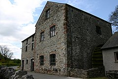
Gleaston Water Mill

Just north of the village is Gleaston Water Mill. Now a tourist attraction, the mill would once have been used to grind oats for farmers throughout the Furness area. The present mill was built in 1774 on the site of an earlier one and its water wheel and milling machinery are still in working order. The Mill is privately owned and was restored in the early 1990s and preserved for posterity. Also on the site are the Dusty Millers restaurant and Pigs Whisper country store.

The village now

Much of the village that can be seen today is 20th century. Since the 1960s the village has experienced a small scale population explosion. Previously there were five farms within the village itself as well as a pub, post office, Co-op and police station, most of which were 19th century buildings. The oldest remaining buildings all date from the 17th century and there are numerous 18th century buildings.

Today, all the amenities and the five farms have disappeared and all the buildings have been converted into dwellings as Gleaston gradually became a commuter village for nearby Barrow and Ulverston. Most of the fields and large gardens in the village were also given over to development as pressure rose in the 1970s and 1980s to provide the growing number of workers at Vickers (now BAE Systems), Glaxo and Furness General Hospital with homes. Gleaston even has its own small estate called Mounts Meadow.

The village has its own large village green, a small football pitch which was made by Bryan Hindle and brothers Paul and John Clarke, a community hall and a children's playground, which are all owned and run by the villagers themselves. Every year a sports day and barbecue is held to raise funds and for locals to meet and enjoy themselves and the village has its own bonfire and fireworks display every November 5. In the year 2000, to celebrate the millennium a short walk was created in a small piece of woodland adjacent to the green, behind the beck.

See also

Related Research Articles

<span class="mw-page-title-main">Ulverston</span> Market town in Cumbria, England

Ulverston is a market town and civil parish in Westmorland and Furness, Cumbria, England. In the 2001 census the parish had a population of 11,524, increasing at the 2011 census to 11,678. Historically in Lancashire, it lies a few miles south of the Lake District National Park and just north-west of Morecambe Bay, within the Furness Peninsula. Lancaster is 39 miles (63 km) to the east, Barrow-in-Furness 10 miles (16 km) to the south-west and Kendal 25 miles (40 km) to the north-east.

<span class="mw-page-title-main">Furness</span> Peninsula and region of Cumbria, England

Furness is a peninsula and region of Cumbria, England. Together with the Cartmel Peninsula it forms North Lonsdale, historically an exclave of Lancashire. On 1 April 2023 it became part of the new unitary authority of Westmorland and Furness.

<span class="mw-page-title-main">Roose</span> Human settlement in England

Roose or Roosecote is a suburb and ward of Barrow-in-Furness, Cumbria, England. The word 'roose' is Celtic for "moor" or "heath" and the suffix 'cote' of Roosecote means "hut" or "huts". Before the building of Roose Cottages and the arrival of the Cornish miners Roose was pronounced with a hard S, as in goose; now it is locally pronounced 'Rooze', due to the Cornish accent. Roose is served by Roose railway station, one of the few remaining stations on the Furness Line in the Barrow area.

<span class="mw-page-title-main">Kirkby-in-Furness</span> Village in the Furness district of Cumbria, England

Kirkby-in-Furness, generally referred to simply as Kirkby locally, is a village that is the major part of the parish of Kirkby Ireleth in the Furness district of Cumbria, England. Historically part of Lancashire, it is close to the Lake District National Park. It is about 3 miles (5 km) south of Broughton in Furness, 5 miles (8 km) northwest of Ulverston and 9 miles (14 km) north of Barrow-in-Furness. It is one of the largest villages on the peninsula's north-western coast, looking out over the Duddon estuary. To its east is the SSSI of Kirkby Moor and to its west is the SSSI of Duddon Estuary. The 2021 census showed Kirkby to have a population of 580.

<span class="mw-page-title-main">Urswick</span> Human settlement in England

Urswick is a civil parish that includes the villages of Great Urswick and Little Urswick. It is located in the Furness area of Cumbria, England. The villages are situated to the south-west of the town of Ulverston. In the 2001 census the parish had a population of 351, decreasing at the 2011 census to 1,397.

<span class="mw-page-title-main">Lindal-in-Furness</span> Human settlement in England

Lindal-in-Furness is a village on the Furness peninsula, in the Westmorland and Furness district of Cumbria, England. Historically in Lancashire, it lies eight miles to the north-east of Barrow-in-Furness, on the A590 trunk road. The civil parish is Lindal and Marton which had a population of 755 at the 2011 Census.

<span class="mw-page-title-main">Bardsea</span> Human settlement in England

Bardsea is a village in the Low Furness area of Cumbria, England. It is two miles to the south-east of Ulverston on the northern coast of Morecambe Bay. It is in the historic county of Lancashire.

<span class="mw-page-title-main">Aldingham</span> Human settlement in England

Aldingham is a village and civil parish in the South Lakeland district of Cumbria, England. Historically in Lancashire, it is situated on the east coast of the Furness peninsula, facing into Morecambe Bay, and is about 8 miles (13 km) east of Barrow-in-Furness, and 6 miles (9.7 km) south of Ulverston. The parish includes the nearby villages of Baycliff, Dendron, Leece, Gleaston, Newbiggin, Roosebeck, Scales and a number of smaller hamlets. According to the 2001 census the parish had a population of 1,187, reducing to 1,105 at the 2011 Census.

<span class="mw-page-title-main">Leece</span> Human settlement in England

Leece is a village on the Furness peninsula in Cumbria, England, between the towns of Ulverston and Barrow-in-Furness.

<span class="mw-page-title-main">Muchland</span> Manor in Low Furness, Cumbria, England

Muchland is a medieval manor in Low Furness in the county of Cumbria in northern England. The manor was the seat of the Lords of Aldingham, and included at its peak the villages of Bardsea, Urswick, Scales, Stainton, Sunbrick, Baycliff, Gleaston, Aldingham, Dendron, Leece and Newbiggin. The area also features the historic remains of Gleaston Castle, Aldingham Castle, Gleaston Water Mill, the Druids' Temple at Birkrigg, plus many prehistoric remains around Urswick and Scales.

<span class="mw-page-title-main">Dendron, Cumbria</span> Human settlement in England

Dendron is a small village in South Cumbria, England. It is situated around three miles from the town of Barrow-in-Furness. The village was once just a collection of farms, but many of the old farm buildings have now been converted into houses for commuters working in Barrow, Ulverston and Dalton.

Scales is a small village in Westmorland and Furness, Cumbria, England. The town of Ulverston is around 3.5 miles south of the village. The name Scales comes from the Old Norse skali, with an Old English plural *Scalas, meaning huts. It is in the historic county of Lancashire.

<span class="mw-page-title-main">Cumbrian toponymy</span> Study of place names in Cumbria, England

Cumbrian toponymy refers to the study of place names in Cumbria, a county in North West England, and as a result of the spread of the ancient Cumbric language, further parts of northern England and the Southern Uplands of Scotland.

<span class="mw-page-title-main">Allithwaite</span> Village in England

Allithwaite is a village in Cumbria, England, located roughly 1.2 miles (1.9 km) west of Grange-over-Sands. Within the boundaries of the historic county of Lancashire, Allithwaite, and the village of Cartmel situated to the north, are part of the civil parish of Lower Allithwaite. At the 2001 census, the parish had a population of 1,758, increasing to 1,831 at the 2011 Census.

<span class="mw-page-title-main">Gleaston Castle</span> 14th-century enclosure castle near Gleaston, England

Gleaston Castle is a medieval building in a valley about 1 kilometre (0.62 mi) north-east of the village of Gleaston. The village lies between the towns of Ulverston and Barrow-in-Furness in the Furness peninsula, Cumbria, England. Gleaston Castle has a quadrilateral plan, with a tower at each corner. The largest of these, the north-west tower, probably housed a hall.

<span class="mw-page-title-main">Askam and Ireleth</span> Civil parish in England

Askam and Ireleth is a civil parish close to Barrow-in-Furness in Westmorland and Furness, Cumbria, England. Historically part of Lancashire, it originally consisted of two separate coastal villages with different origins and histories which, in recent times, have merged to become one continuous settlement. In the 2001 census the parish had a population of 3,632, reducing at the 2011 census to 3,462.

<span class="mw-page-title-main">John Harington, 1st Baron Harington</span>

John Harington, 1st Baron Harington (1281–1347) of Aldingham in Furness, Lancashire, was an English peer, created Baron Harington by writ of summons to Parliament dated 1326.

<span class="mw-page-title-main">John Harington, 2nd Baron Harington</span>

John Harington, 2nd Baron Harington (1328–1363) of Aldingham in Furness, Cumbria, was an English peer, who inherited the title Baron Harington in 1347 on the death of his grandfather John Harington, 1st Baron Harington (1281–1347).

The Manor of Hougun is the historic name for an area which now forms part of the county of Cumbria in North West England. Only the southern band of land in the south of Cumbria was surveyed in the Domesday Book. The westernmost entries for Cumbria, covering the Duddon and Furness Peninsulas are largely recorded as part of the Manor of Hougun. The entry in Domesday Book covering Hougun refers to the time when it was held by Tostig Godwinson, Earl of Northumbria.

Aldingham is a civil parish in the South Lakeland District of Cumbria, England. It contains 28 listed buildings that are recorded in the National Heritage List for England. Of these, one is listed at Grade I, the highest of the three grades, one is at Grade II*, the middle grade, and the others are at Grade II, the lowest grade. The parish contains villages, including Aldingham, Baycliff, Dendron, Leece, Gleaston, and Scales, and the surrounding countryside. The listed buildings include houses and associated structures, farmhouses and farm buildings, churches and items in a churchyard, a ruined castle, a Friends' burial ground, a former corn mill, two village halls, one originally a malt kiln, three follies, and four limekilns.

References

  1. 1 2 "Aldingham Parish". Images of Cumbria. 22 March 2008. Retrieved 18 August 2009. Cites Mannix & Co., History, Topography and Directory of Westmorland, 1851
  2. Gleaston and its Water Mill