
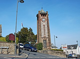
Ulverston is a market town and civil parish in Westmorland and Furness, Cumbria, England. Historically in Lancashire, it lies a few miles south of the Lake District National Park and just north-west of Morecambe Bay, within the Furness Peninsula. Lancaster is 39 miles (63 km) to the east, Barrow-in-Furness 10 miles (16 km) to the south-west and Kendal 25 miles (40 km) to the north-east. In the 2001 census the parish had a population of 11,524, increasing at the 2011 census to 11,678.
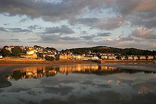
Grange-over-Sands is a town and civil parish on the north side of Morecambe Bay in Cumbria, England, a few miles south of the Lake District National Park. In the 2011 census the parish had a population of 4,114, increasing at the 2021 census to 4,279. Within the boundaries of the historic county of Lancashire, the town became administered as an urban district in 1894. Though the town remains part of the Duchy of Lancaster, since 2023 it has been administered as part of the Westmorland and Furness Council area.
Arnside is a village and civil parish in Westmorland and Furness, Cumbria, England. It is historically part of Westmorland, near the border with Lancashire, England. The Lake District National Park is located a few miles north. Travelling by road, Arnside is 10 miles (16 km) to the south of Kendal, 25.3 miles (40.7 km) to the east of Ulverston, 35.2 miles (56.6 km) to the east of Barrow-in-Furness, 13 miles (21 km) to the north of Lancaster and 14.3 miles (23.0 km) to the east of Grange-over-Sands. In the 2001 census the parish had a population of 2,301, increasing at the 2011 census to 2,334.

Roose or Roosecote is a suburb and former ward of Barrow-in-Furness, Cumbria, England. The word 'roose' is Celtic for "moor" or "heath" and the suffix 'cote' of Roosecote means "hut" or "huts". Before the building of Roose Cottages and the arrival of the Cornish miners Roose was pronounced with a hard S, as in goose; now it is locally pronounced 'Rooze', due to the Cornish accent. Roose is served by Roose railway station, one of the few remaining stations on the Furness Line in the Barrow area.

Kents Bank is a small village in Cumbria, England, so named for its proximity to the River Kent estuary. Part of the historic County Palatine of Lancashire, it is located 2 miles (3.2 km) south-west of Grange-over-Sands.

Bardsea is a village in the Low Furness area of Cumbria, England. It is two miles to the south-east of Ulverston on the northern coast of Morecambe Bay. It is in the historic county of Lancashire.

Gleaston is a village with a population of around 400 in the Furness area of South Cumbria, situated between the towns of Barrow-in-Furness, Dalton-in-Furness and Ulverston. Historically in Lancashire, the history of the village can be traced as far back as the mesolithic period and it was the centre of the manor of Muchland in the Middle Ages. Today it is largely a commuter village for the nearby towns, but its past is still visible in the remains of Gleaston Castle and Gleaston Water Mill, which is open as a tourist attraction.

Leece is a village on the Furness peninsula in Cumbria, England, between the towns of Ulverston and Barrow-in-Furness.

Muchland is a medieval manor in Low Furness in the county of Cumbria in northern England. The manor was the seat of the Lords of Aldingham, and included at its peak the villages of Bardsea, Urswick, Scales, Stainton, Sunbrick, Baycliff, Gleaston, Aldingham, Dendron, Leece and Newbiggin. The area also features the historic remains of Gleaston Castle, Aldingham Castle, Gleaston Water Mill, the Druids' Temple at Birkrigg, plus many prehistoric remains around Urswick and Scales.

Great Salkeld is a small village and civil parish in Westmorland and Furness, Cumbria, England, a few miles to the north east of Penrith and bordering the River Eden. At the 2001 census the parish had a population of 445, decreasing to 412 at the 2011 Census.
Dendron is a small village in South Cumbria, England. It is situated around three miles from the town of Barrow-in-Furness. The village was once just a collection of farms, but many of the old farm buildings have now been converted into houses for commuters working in Barrow, Ulverston and Dalton.

Gleaston Castle is a medieval building in a valley about 1 kilometre (0.62 mi) north-east of the village of Gleaston. The village lies between the towns of Ulverston and Barrow-in-Furness in the Furness peninsula, Cumbria, England. Gleaston Castle has a quadrilateral plan, with a tower at each corner. The largest of these, the north-west tower, probably housed a hall.
Warcop is a village and civil parish in the Eden district of Cumbria, England, which had a population of 532 at the 2011 census.

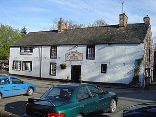
Baycliff is a seaside village in the Westmorland and Furness unitary authority area of Cumbria in England. Historically in Lancashire, it lies 3 miles (4.8 km) south of Ulverston, in the civil parish of Aldingham. At the centre is a village green, and many of its buildings date from the 17th and 18th centuries. The two public houses, the Farmer's Arms and the Fisherman's Arms, stand close to the green.
Morland is a village and civil parish in the rolling hills of the Eden Valley in Cumbria, England. It lies within the historic county of Westmorland. The parish includes the hamlets of Town Head and Morland Moor, and had a population of 380 in 2001, reducing marginally to 374 at the 2011 Census.

Newbiggin is a village on the A5087 road, in the civil parish of Aldingham, in Furness, in the unitary authority area of Westmorland and Furness, in the ceremonial county of Cumbria, England. Historically in Lancashire, nearby settlements include the large town of Barrow-in-Furness, the village of Aldingham and the hamlet of Roosebeck.
The Manor of Hougun is the historic name for an area which now forms part of the county of Cumbria in North West England. Only the southern band of land in the south of Cumbria was surveyed in the Domesday Book. The westernmost entries for Cumbria, covering the Duddon and Furness Peninsulas are largely recorded as part of the Manor of Hougun. The entry in Domesday Book covering Hougun refers to the time when it was held by Tostig Godwinson, Earl of Northumbria.
Aldingham is a civil parish in the South Lakeland District of Cumbria, England. It contains 28 listed buildings that are recorded in the National Heritage List for England. Of these, one is listed at Grade I, the highest of the three grades, one is at Grade II*, the middle grade, and the others are at Grade II, the lowest grade. The parish contains villages, including Aldingham, Baycliff, Dendron, Leece, Gleaston, and Scales, and the surrounding countryside. The listed buildings include houses and associated structures, farmhouses and farm buildings, churches and items in a churchyard, a ruined castle, a Friends' burial ground, a former corn mill, two village halls, one originally a malt kiln, three follies, and four limekilns.
Roosebeck is a hamlet in the Unitary Authority of Westmorland and Furness, Cumbria, England, on the north west coast of Morecambe Bay. It is in the civil parish of Aldingham.


