Longtown, Cumbria

Last updated

Longtown
Town
Longtown Bridge over the River Esk.jpg
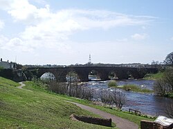
Longtown, bridge over the River Esk
Location map United Kingdom City of Carlisle.svg
Red pog.svg
Longtown
Location in the former City of Carlisle
Cumbria UK location map.svg
Red pog.svg
Longtown
Location within Cumbria
Population3,000 
OS grid reference NY380686
Civil parish
Unitary authority
Ceremonial county
Region
Country England
Sovereign state United Kingdom
Post town Carlisle
Postcode district CA6
Dialling code 01228
Police Cumbria
Fire Cumbria
Ambulance North West
UK Parliament
List of places
UK
England
Cumbria
55°00′30″N2°58′07″W / 55.0084°N 2.9687°W / 55.0084; -2.9687

Longtown is a market town in Cumbria, England, just south of the Scottish Border. It has a sheep market which was at the centre of the 2001 United Kingdom foot-and-mouth crisis. Just south-west of Longtown is Arthuret Church, dedicated to Saint Michael and All Angels.

Contents

Location

It is in the parish of Arthuret and on the River Esk. Longtown is 11+34 miles (19 kilometres) north of Carlisle and 27+12 miles (44 kilometres) east of Dumfries.

History

Historically in Cumberland, nearby was the Battle of Arfderydd in 573. The Battle of Solway Moss was fought nearby in 1542.

2001 UK Foot and mouth crisis

Longtown is the location of the largest sheep markets in England. The first animal to be found infected with foot-and-mouth disease in the 2001 crisis had been purchased at Longtown Market. While at the market it spread the infection to other animals. The size of the Longtown Sheep Market meant that the disease had spread right across the country in a very short time. Longtown became the centre for control of the disease in south western Scotland and North West England.

Governance

Longtown is in the parliamentary constituency of Carlisle.

For Local Government purposes it is administered as part of the Cumberland unitary authority.

Longtown has its own parish council; Arthuret Parish Council. [1]

Education

Longtown has one primary school with around 190 pupils. Most secondary school pupils travel to William Howard School, Brampton, or Carlisle. Though up until 2008 Longtown had its own secondary school, Lochinvar School.

Media

Local news and television programmes are provided by BBC North East and Cumbria and ITV Border. Television signals are received from the Caldbeck TV transmitter. [2] Local radio stations are BBC Radio Cumbria on 95.6 FM, BBC Radio Scotland can also be heard on 94.7 FM and Greatest Hits Radio Cumbria & South West Scotland on 96.4 FM. The town is served by the local newspaper, News and Star. [3]

Environment

In April 2014 Carlisle City Council rejected a planning application for a 2-million-imperial-gallon (9-million-litre) slurry lagoon at Scaurbank Wood, to the north east of Longtown. The planned slurry lagoon was said to be the most objected to plan in the City Council's history, with more than 1,400 letters or e-mails of objection. [4]

Industry

Coal mining

Lochinvar coalfield was discovered in the 1950s by the National Coal Board and was subject to drilling but never mined. From 2014 an Australian firm was exploring the coalfield for coking coal to produce steel. [5] [6] The company was exploring as far north as Evertown near Canonbie, and as far south as Longtown.

DMC Longtown

During the 1930s, there was a recognition of a need to provide secure storage for munitions across the United Kingdom. The proposal was to create three Central Ammunition Depots (CAD): one in the south (Monkton Farleigh, Wiltshire); one in the Midlands (Nesscliffe, Shropshire); and one in the north. [7]

While the other two sites were sat above easily hewn limestone, Longtown is located above granite, which meant that it took longer to create and only came into operations late in the Second World War. The site was chosen as it used to be part of HM Factory, Gretna, that stretched to Eastriggs over the border in Scotland, one of the biggest makers of explosives during the First World War. The township of Gretna was established to house the workers of this establishment. [8]

Today, DMC (Defence Munitions Centre) Longtown is the only one of the three CADs to remain in operation and is among the largest defence munitions sites in Western Europe. Currently, Longtown and Eastriggs are two separate sites under joint management. In November 2013 the MoD announced that the operational capacity of MoD Longtown would be reduced and a small area of the site would be given over to commercial use. [9]

See also

Related Research Articles

<span class="mw-page-title-main">Carlisle</span> City in Cumbria, England

Carlisle is a city located in the Northern English county of Cumbria. It is administrated by Cumberland Council, which covers an area similar to the historic county of Cumberland.

<span class="mw-page-title-main">Workington</span> Coastal town in Cumbria, England

Workington is a coastal town and civil parish at the mouth of the River Derwent on the west coast in Cumbria, England. At the 2011 census it had a population of 25,207.

<span class="mw-page-title-main">Cumberland</span> Historic county of England

Cumberland is an area of North West England which was historically a county. The county was bordered by Northumberland to the north-east, County Durham to the east, Westmorland to the south-east, Lancashire to the south, and the Scottish counties of Dumfriesshire and Roxburghshire to the north. The area includes the city of Carlisle, part of the Lake District and North Pennines, and the Solway Firth coastline.

<span class="mw-page-title-main">Aspatria</span> Town in Cumbria, England

Aspatria is a town and civil parish in Cumberland, Cumbria, England. The town rests on the north side of the Ellen Valley, overlooking a panoramic view of the countryside, with Skiddaw to the South and the Solway Firth to the North. Its developments are aligned approximately east–west along the A596 Carlisle to Workington road and these extend to approximately 2 miles (3.2 km) in length. It lies about 8 miles (13 km) northeast of Maryport, a similar distance to the Southwest of Wigton, about 9 miles (14 km) north of Cockermouth and 5 miles (8.0 km) from the coast and Allonby. It comprises the townships of Aspatria and Brayton, Hayton and Mealo, and Oughterside and Allerby, the united area being 8,345 acres (3,377 ha); while the town takes up an area of 1,600 acres (647 ha). In earlier days a Roman road leading from "Old Carlisle" to Ellenborough passed through the hamlet.

Gretna is a town in Dumfries and Galloway, Scotland, originally part of the historic county of Dumfriesshire. It is located close to the A74(M) on the border of Scotland and England and near the mouth of the River Esk.

<span class="mw-page-title-main">Maryport</span> Town in Cumbria, England

Maryport is a town and civil parish in the Cumberland district, in the ceremonial county of Cumbria, England. In 2011 the parish had a population of 11,262.

<span class="mw-page-title-main">Nesscliffe</span> Human settlement in England

Nesscliffe is a village in Shropshire, England, located north of the River Severn. The village comes under the Great Ness parish.

<span class="mw-page-title-main">Kirkby Stephen</span> Market town in Cumbria, England

Kirkby Stephen is a market town and civil parish in Cumbria, England. It lies on the A685 and is surrounded by sparsely populated hill country, about 25 miles (40 km) from the nearest larger towns, Kendal and Penrith. The River Eden rises 6 miles (10 km) away in the peat bogs below Hugh Seat and passes the eastern edge of the town. At the 2001 census the parish had a population of 1,832. In 2011, it had a population of 1,522.

<span class="mw-page-title-main">Wigton</span> Market town in Cumbria, England

Wigton is a market town in Cumberland, Cumbria, England. It lies just outside the Lake District. Wigton is at the centre of the Solway Plain, between the Caldbeck Fells and the Solway coast. It is served by Wigton railway station on the Cumbrian Coast Line, and the A596 road to Workington. The town of Silloth-on-Solway lies 12 miles (19 km) to the west, beyond Abbeytown.

<span class="mw-page-title-main">Brampton, Carlisle</span> Town and parish in England

Brampton is a market town and civil parish in the Cumberland unitary authority of Cumbria, England. It is 9 miles (14 km) east of Carlisle and 2 miles (3.2 km) south of Hadrian's Wall. Historically part of Cumberland, it is situated off the A69 road which bypasses it.

<span class="mw-page-title-main">Penrith and The Border (UK Parliament constituency)</span> Parliamentary constituency in the United Kingdom, 1950–2024

Penrith and The Border was a constituency in Cumbria represented in the House of Commons of the UK Parliament. Throughout its existence it elected only members of the Conservative Party.

<span class="mw-page-title-main">Silloth</span> Port town in Cumbria, England

Silloth is a port town and civil parish in Cumberland, Cumbria, England. Historically in the county of Cumberland, the town is an example of a Victorian seaside resort in the North of England.

<span class="mw-page-title-main">Caldbeck</span> Village in Cumbria, England

Caldbeck is a village in Cumbria, England, historically within Cumberland, it is situated within the Lake District National Park. The village had 714 inhabitants according to the census of 2001.

<span class="mw-page-title-main">Monkton Farleigh</span> Village in Wiltshire, England

Monkton Farleigh is a village and civil parish in west Wiltshire, England, on high ground 3 miles (5 km) northwest of Bradford-on-Avon, and a similar distance east of the city of Bath. The parish includes the hamlets of Farleigh Wick and Pinckney Green. In the west and northwest the parish is bounded by Somerset.

<span class="mw-page-title-main">HM Factory, Gretna</span> Cordite Production Plant in Gretna, Scotland, during the First World War

H.M. Factory, Gretna was Britain's largest cordite factory during the First World War. The government-owned facility was adjacent to the Solway Firth, near Gretna, Dumfries and Galloway. It was built by the Ministry of Munitions in response to the Shell Crisis of 1915. The capital cost was £9,184,000 and it covered 9,000 acres (36 km2). The cost of working it from September 1916 to September 1918 was £12,769,000, during which time it produced cordite valued at £15,000,000, though it was claimed that without it the cordite would have had to be imported from the USA at a cost of £23,600,000.

Eastriggs is a small village located in Dumfries and Galloway in the south of Scotland, the village is located around 2 mi (3.2 km) north of the mud and sandbanks of the channel of the River Eden, which extends west into the Solway Firth.

<span class="mw-page-title-main">Hesket Newmarket</span> Human settlement in England

Hesket Newmarket is a small village in Cumbria, England, historically within Cumberland. It is on the opposite side of Skiddaw to Keswick within the Lake District National Park.

<span class="mw-page-title-main">Pontrilas Army Training Area</span>

Pontrilas Army Training Area is a British Army training camp, located just north of the village of Ewyas Harold near to Pontrilas in Herefordshire, England. Originally developed pre-World War II by the Ministry of Defence (MoD) as an ammunition dump, it was served by the Golden Valley Railway.

Brackenhill Tower is a peel tower, in the parish of Arthuret, in Cumbria, just north of the River Lyne. The site is about 2 miles (3.2 km) north of Kirklinton and 4 miles (6.4 km) east of Longtown, or 10 miles (16 km) north of Carlisle and 8 miles (13 km) east of Gretna Green, and is a good defensive position, with ravines to the north and south. Extensions were added in the 18th and 19th centuries, but the original tower has had little alteration. It is the only remaining example of a Scottish tower house south of the border with England, and became a Grade II* listed building in 1957.

<span class="mw-page-title-main">Kirklinton Middle</span> Civil parish in Carlisle, Cumbria, England

Kirklinton Middle is a civil parish in the Cumberland district of Cumbria, England. At the 2011 census, it had a population of 384.

References

  1. "Arthuret Parish Council".
  2. "Full Freeview on the Caldbeck (Cumbria, England) transmitter". UK Free TV. Retrieved 3 June 2024.
  3. "News and Star". British Papers. 11 April 2014. Retrieved 3 June 2024.
  4. 'Tide against the slurry lagoon plan too strong to be ignored' - the Cumberland News 18 April 2014
  5. The Cumberland News 7 March 2014 'Coal-mining scheme set to expand'
  6. BICK, Duncan (19 May 2017). "Coal mine drilling to start near Longtown this year". The Cumberland News (News and Star). Retrieved 15 January 2023.
  7. "Monkton Farleigh Ammo Depot". Pillbox Study Group. Retrieved 26 April 2022.
  8. "Gretna Green - Scandal of cost of Munitions Town". Sheffield Evening Telegraph . 8 August 1919. p. 2.
  9. "Longtown munitions depot to stay open". BBC News. Retrieved 26 April 2022.