Silloth had a population of 2,932 at the 2001 Census,[1] falling slightly to 2,906 at the 2011 Census.[2]
Location
It sits on the shoreline of the Solway Firth, 18+3⁄4 miles (30 kilometres) north of Workington and 22 miles (35 kilometres) west of Carlisle. The town of Maryport lies 12 miles (19 kilometres) south, down the B5300 coast road which also passes through the villages of Blitterlees, Beckfoot, Mawbray, and Allonby. Wigton is 12 miles (19 kilometres) east, along the B5302 road, which also passes through the village of Abbeytown, 5+1⁄2 miles (9 kilometres) southeast.
History
Silloth developed in the 1860s onwards around the terminus of the railway from Carlisle and the associated docks, which were constructed from 1855 to replace Port Carlisle as the deep-water port for Carlisle.
The town also offered workers from the factories of Carlisle access to the seaside, and the town flourished as a destination for day trippers. The town's popularity peaked in the late 19th and early 20th centuries.
Etymology
'Silloth' means "'sea barn(s)', v. 'sǣ hlaða'."[3] (The first word is Old English, the second is Old Norse).
Silloth has its own Parish Council: Silloth-on-Solway Town Council.[5]
Churches
Christ Church, Silloth, occupies a complete rectangle of the planned town
Silloth's largest church is Christ Church, situated in a complete rectangular plot which was planned into the original town design. It is on a commanding site at Criffel Street and the body of the church was completed in 1870.[6] The porch tower and large broach spire were completed later in 1878, and house a ring of 8 bells which are chimed. It was designed by Carlisle architect Charles John Ferguson in the Gothic style, and is built with an interesting mix of local sandstone, and granite which was brought by the North British Railway (and boats) from Newry, now in Northern Ireland. Much of the interior is faced with yellow brick trimmed with red.[7]
There are several churches and chapels of other denominations in the town.
Industry
Silloth docks 2008
Port of Silloth
The Port of Silloth is owned and operated by Associated British Ports. The main cargoes are wheat, fertiliser, molasses, forest products and general cargo.[8]
Carr's Flour Mill
An example of a Victorian flour mill, the building was constructed adjacent to the New Dock in 1887. Carr'sflour mill is an operating mill which supplies flour to a number of food manufacturers such as United Biscuits,[9]Warburtons and several other leading bakeries and confectioners. Carr's Flour Mill is now owned by Whitworths.
Cheri Foam
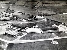
Silloth Airfield factory
In the 1960s two businesses that had outgrown their factory in Whitehaven re-located to Silloth airfield. They were Cumberland Curled Hair and Cheri Foam. They were one of the largest employers in the area until the late 1970s. Cheri Foam, was owned by Kurt Oppenheim, who had established his business originally in Whitehaven in 1946. He bought two of the hangars on the airfield and later joined them together to create large factory space and storage units for the manufacture of polyurethane foam blocks. This was an industrial chemical process and a foam block conversion unit ('Conversion' means that the blocks were cut up into shapes like cushions and sheets to be supplied to the furniture, bedding and motor industries). In 1973 an additional factory unit was added to house the production of foam moulded car parts by high pressure injection foam machines. Machinery equipment in the factory was largely manufactured by a team of Silloth metal fitters and local electricians employed full time by the factory. There was a laboratory and a fibreglass mould making unit on site as well as a garaging unit to service the fourteen container vans that the company used to ship its production all over the UK. It was a twenty four hours a day operation with production leaving the works at all hours. The logo Cheri Foam on the sides of vans was very familiar in the area. About a hundred and fifty people worked in this factory, some from Silloth and many bussed in from Maryport and surrounds each day. The business was acquired by the Beaver Group in 1976 and Oppenheim retired to join his family in London. The main customer Times Furnishing eventually closed and after this the business ran down and eventually closed.[citation needed]
Other
Local contractor D.A. Harrison are based in Silloth, employing 200 people.[10][11]
Sports
Silloth A.F.C.
Silloth A.F.C. (also known as the Silloth Seagulls) is an amateur football club currently competing in the Cumberland County League. The club features a range of teams, including a men's squad and a thriving junior section for both boys and girls, providing opportunities for players of all ages to develop and compete.
In 2025, Kian Orchard was appointed as Head Coach, bringing fresh ideas, strong leadership, and a new vision to the club.
The Seagulls play their home matches at Eden Street Playing Fields, a ground they have called home since 1954. In 2022, the club announced plans to construct a new clubhouse to support the expansion of its junior programs. This development aims to enhance facilities for both existing members and the wider community.
Silloth has long been a popular tourist destination.
Tourism is a major contributor to the economy in Silloth, with dozens of large and small static and touring caravan parks located within a 10 miles (15 kilometres) radius of the town centre, resulting in a large increase in the population during the summer months.
Silloth hosts several small annual events held on the town green. These include a beer festival held in September, plus a steam rally, kite and food festivals.[12]
A local 'free' newspaper published monthly entitled The Solway Buzz, distributed to households in the area by a team of volunteers, covers news and events in Silloth and the surrounding area.[14] The town is also served by the regional newspaper the News & Star.[15]
The airfield opened in June 1939, just before the start of the Second World War, and closed on 31 December 1960. Originally designed to be used by RAF Maintenance Command, 22MU, the airfield was handed over to Coastal Command during November 1939. No 1 Operational Training Unit (OTU) was then responsible for training pilots and crews from the UK and Allied Countries. Therefore, the aerodrome had twin responsibilities, the maintenance and repair of planes for use in the war effort and the training of crews from allied countries to fly planes.[18]
The railway to Silloth opened in 1856. The line passed through the villages of Kirkbride and Abbeytown to Carlisle. The railway carried both passengers and freight from the port, and tourists visiting the town. It was closed as part of the Beeching cuts in 1964.[19]
Road
Silloth is on the B5302 road, which leads to the A596 and the town of Wigton, and the B5300 which connects the town to Maryport.
↑ Armstrong, A. M.; Mawer, A.; Stenton, F. M.; Dickens, B. (1950). The place-names of Cumberland. English Place-Name Society, vol.xx. Vol.Part 2. Cambridge: Cambridge University Press. pp.293–4.
↑ Hyde, Matthew; Pevsner, Nikolaus (2010) [1967], Cumbria, The Buildings of England, New Haven and London: Yale University Press, ISBN978-0-300-12663-1
This page is based on this Wikipedia article Text is available under the CC BY-SA 4.0 license; additional terms may apply. Images, videos and audio are available under their respective licenses.