
Carlisle is a city located in the Northern English county of Cumbria. It is administrated by Cumberland Council, which covers an area similar to the historic county of Cumberland.
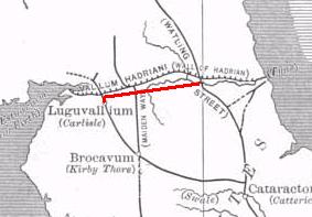
The Stanegate was an important Roman road and early frontier built in what is now northern England. It linked many forts including two that guarded important river crossings: Corstopitum (Corbridge) on the River Tyne in the east and Luguvalium (Carlisle) in the west. The Stanegate ran through the natural gap formed by the valleys of the River Tyne in Northumberland and the River Irthing in Cumbria. It predated the Hadrian's Wall frontier by several decades; the Wall would later follow a similar route, albeit slightly to the north.
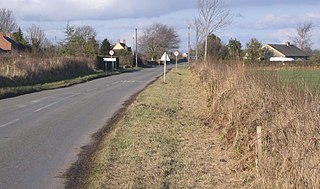
Wigton is a market town in Cumberland, Cumbria, England. It lies just outside the Lake District. Wigton is at the centre of the Solway Plain, between the Caldbeck Fells and the Solway coast. It is served by Wigton railway station on the Cumbrian Coast Line, and the A596 road to Workington. The town of Silloth-on-Solway lies 12 miles (19 km) to the west, beyond Abbeytown.

Hadrian's Wall Path is a long-distance footpath in the north of England, which became the 15th National Trail in 2003. It runs for 84 miles (135 km), from Wallsend on the east coast of England to Bowness-on-Solway on the west coast. For most of its length it is close to the remains of Hadrian's Wall, the defensive wall built by the Romans on the northern border of their empire. This is now recognised as part of the "Frontiers of the Roman Empire" World Heritage Site.

Beaumont is a village and civil parish in the Cumberland district of Cumbria, England. The village lies four miles north-west of Carlisle on the banks of the River Eden. In 2011 the parish had a population of 488.

Burgh by Sands is a village and civil parish in the Cumberland unitary authority area of Cumbria, England, situated near the Solway Firth. The parish includes the village of Burgh by Sands along with Longburgh, Dykesfield, Boustead Hill, Moorhouse and Thurstonfield. It is notable as the site of the first recorded North African (Mauri) military unit in Roman Britain, garrisoning the frontier fort of Aballava on Hadrian's Wall in the 3rd century AD. It is also where Edward I of England died in 1307.

Bowness-on-Solway is a village in Cumbria, England. It is situated to the west of Carlisle on the southern side of the Solway Firth estuary separating England and Scotland. The civil parish had a population of 1,126 at the 2011 census. The western end of Hadrian's Wall is a notable tourist destination, though the Wall itself is no longer to be seen here above ground. The west end of the Hadrian's Wall Path is marked by a pavilion on the small coastal cliff at Bowness. The village is part of the Solway Coast Area of Outstanding Natural Beauty.
Luguvalium was an ancient Roman city in northern Britain located within present-day Carlisle, Cumbria, and may have been the capital of the 4th-century province of Valentia. It was the northernmost city of the Roman Empire.

Crosby-on-Eden is the combined name for two small villages, High Crosby and Low Crosby, within the civil parish of Stanwix Rural near Carlisle, in the Cumberland district, in the ceremonial county of Cumbria, England. It was formerly a parish in its own right under the name Crosby upon Eden. In 1931, the parish had a population of 238. On 1 April 1934, the parish was abolished and merged with Stanwix Rural, part also went to Wetheral.

Upper Denton is a small village and civil parish in the north of Cumbria, England, about 1 km north of the A69 road linking Haltwhistle and Brampton. The population of the civil parish when taken at the Census of 2011 was less than 100. Details are included in the parish of Nether Denton. The village is situated on the line of the Roman Stanegate road which ran from Corbridge (Coria) to Carlisle (Luguvalium). Just 1 km to the north across the river Irthing is Birdoswald fort on Hadrian's Wall. Nearby villages include Gilsland, Greenhead and Lanercost.

Coggabata, or Congavata / Concavata, was a Roman fort on Hadrian's Wall, between Aballava to the east and Mais (Bowness-on-Solway) to the west. It was built on a hill commanding views over the flatter land to the east and west and to the shore of the Solway Firth to the north. Its purpose was to guard the southern end of two important Solway fords, the Stonewath and the Sandwath.
Maia, or Mais, in Cumbria, England was a Roman fort on Hadrian's Wall, and was the last fort at the western end of the Wall, overlooking the Solway Firth.

Brampton Old Church stands about 1 mile (2 km) to the west of the town of Brampton, Cumbria, England. It was originally the parish church of Brampton but is now redundant. The church is recorded in the National Heritage List for England as a designated Grade II* listed building.

Nether Denton is a scattered settlement and civil parish in rural Cumbria, England, situated about 12 miles (19 km) north-east of Carlisle, by the A69 road. The population of the parish taken at the 2011 census was 415. Nether Denton is a couple of miles south-west of the village of Upper Denton. The parish contains the village of Low Row.
Holme Low is a civil parish in the Cumberland unitary authority of Cumbria, United Kingdom. It borders the parishes of Holme St. Cuthbert and Holme Abbey to the south, the town of Silloth-on-Solway to the north-west, and has a short stretch of coastline on the Solway Firth to the west. To the north, it is bordered by lands common to Holme St. Cuthbert, Holme Low, and Holme Abbey, which is an unpopulated area. Holme Low had a population of 373 in 137 households at the 2001 census, reducing slightly in the 2011 Census to a population of 362 in 162 households.

New Cowper is a small hamlet in the civil parish of Holme St. Cuthbert in Cumbria, United Kingdom. It is located three-and-a-half miles south-east of the village of Mawbray, one-and-a-half miles north-west of Westnewton, and twenty-one-and-a-half miles south-west of Carlisle, Cumbria's county town.

The B5302 is a B road which runs for approximately twelve-and-a-quarter miles between the towns of Silloth-on-Solway and Wigton in Cumbria, United Kingdom. From west to east, it passes through the villages of Causewayhead, Calvo, Abbeytown, Wheyrigg, and Waverbridge, and also passes near to Blackdyke and Blencogo. At its eastern end, it comes very close to the Solway Coast Area of Outstanding Natural Beauty, and passes by Silloth Airfield, left over from the Second World War. Several of the villages that the road passes through were formerly served by trains on the single-track Carlisle and Silloth Bay Railway, which closed with the Beeching axe in the 1960s. It is the main road connecting Silloth-on-Solway and surrounding settlements with the A596, and by extension, the city of Carlisle.
Holme East Waver is a civil parish in Cumbria, United Kingdom. It is bordered to the north by the civil parish of Bowness-on-Solway, to the east by the civil parishes of Kirkbride, Woodside, and Waverton, and to the south by the civil parishes of Dundraw and Holme Abbey, lands common to Holme St. Cuthbert, Holme Low, and Holme Abbey, and the town of Silloth-on-Solway. At the 2001 census, it had a population of 306 in 121 households, increasing slightly at the 2011 Census to a population of 318 in 130 households. It is named for the River Waver, and the rivers Waver and Wampool enter the Solway Firth at the western end of the parish. Part of the Solway Coast Area of Outstanding Natural Beauty is within the parish of Holme East Waver. The largest village is Newton Arlosh.

Roman Cumbria was an area that lay on the north-west frontier of Roman Britain, and, indeed, of the Roman Empire itself.. Interest in the Roman occupation of the region lies in this frontier aspect: why did the Romans choose to occupy the north-west of England; why build a solid barrier in the north of the region ; why was the region so heavily militarised; to what extent were the native inhabitants "Romanised" compared to their compatriots in southern England?

Kelsick is a hamlet in the civil parish of Dundraw in Cumbria, United Kingdom. It is located approximately 1.8 miles (2.9 km) southeast of Abbeytown, 0.9 miles (1.4 km) northwest of Dundraw, and 14.5 miles (23.3 km) west of Carlisle, Cumbria's county town. Kelsick is accessed by two side-roads off the B5302 road, which runs between Silloth and Wigton.


