Stanegate

Last updated

Stanegate
Roman Road
Stanegate.jpg
Route of the Stanegate
Route information
Length38 mi (61 km)
Time period Roman Britain
Margary number 85
Major junctions
From Corstopitum
Major intersections Vindolanda, Magnis
To Luguvalium
Location
Country United Kingdom
Road network
Forts on Stanegate and Hadrian's wall Forts on Stanegate and Hadrian's wall.png
Forts on Stanegate and Hadrian's wall

The Stanegate (meaning "stone road" in Northumbrian dialect [1] ) was an important Roman road and early frontier built in what is now northern England. It linked many forts including two that guarded important river crossings: Corstopitum (Corbridge) on the River Tyne in the east (situated on Dere Street) and Luguvalium (Carlisle) (on the River Eden) in the west. The Stanegate ran through the natural gap formed by the valleys of the River Tyne in Northumberland and the River Irthing in Cumbria. It predated the Hadrian's Wall frontier by several decades; the Wall would later follow a similar route, albeit slightly to the north.

Contents

The Stanegate should not be confused with the two Roman roads called Stane Street in the south of England, namely Stane Street (Chichester) and Stane Street (Colchester). In both these cases the meaning is the same as for the northern version, indicating a stone or paved road.

The Stanegate differed from most other Roman roads in that it often followed the easiest gradients, and so tended to weave around, whereas typical Roman roads follow a straight path, even if this sometimes involves having punishing gradients to climb. [2]

A large section of the Stanegate is still in use today as a modern minor road between Fourstones and Vindolanda in Northumberland.

History

The Stanegate is believed to have been built under the governorship of Agricola, from 77 to 85 AD, during the reigns of the emperors Vespasian, Titus, and Domitian. It is also thought that it was built as a strategic road when the northern frontier was on the line of the Forth and Clyde. An indication of this is that it was provided with forts at one-day marching intervals (14 Roman miles or modern 13 miles (21 km)), sufficient for a strategic non-frontier road. [3] The forts at Vindolanda (Chesterholm) and Nether Denton have been shown to date from about the same time as Corstopitum and Luguvalium, in the 70s and 80s AD.

When the Romans decided to withdraw from Scotland starting from around 87 AD, [4] the line of the Stanegate gradually became the new frontier and it became necessary to provide forts at half-day marching intervals. These additional forts were Newbrough, Magnis (Carvoran), and Brampton Old Church. It has been suggested that a series of smaller forts were built in between the 'half-day-march' forts. Haltwhistle Burn and Throp might be such forts, but there is insufficient evidence to confirm a series of such fortlets. [5]

Structure

The line of the Stanegate looking east, within the Corbridge Roman Site Corbridge stangate.jpg
The line of the Stanegate looking east, within the Corbridge Roman Site
An in situ Roman milestone on the Stanegate adjoining Vindolanda fort Pasture, Bradley Burn and Roman milestone, near Vindolanda - geograph.org.uk - 409042.jpg
An in situ Roman milestone on the Stanegate adjoining Vindolanda fort

Where it left the base of Corstopitum, the Stanegate was 22 feet (6.7 m) wide with covered stone gutters and a foundation of 6-inch (150 mm; 15 cm) cobbles with 10 inches (250 mm; 25 cm) of gravel on top. [6]

Route

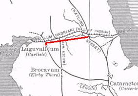
The Stanegate began in the east at Corstopitum, where the important road, Dere Street headed towards Scotland. West of Corstopitum, the Stanegate crossed the Cor Burn, and then followed the north bank of the Tyne until it reached the North Tyne near the village of Wall. A Roman bridge must have taken the road across the North Tyne, from where it headed west past the present village of Fourstones to Newbrough, where the first fort is situated, 7+12 miles (12.1 km) from Corbridge, and 6 miles (9.7 km) from Vindolanda. It is a small fort occupying less than 1 acre (0.40 ha) and is in the graveyard of Newbrough church, which stands alone to the west of the village. [6]

From Newbrough, the Stanegate proceeds west, parallel to the South Tyne until it meets the next major fort, at Vindolanda (Chesterholm). From Vindolanda the Stanegate crosses the route of the present-day Military Road and passes just south of the minor fort of Haltwhistle Burn. From Haltwhistle Burn, the Stanegate continues west away from the course of the South Tyne and passes the major fort of Magnis (Carvoran), 6+12 miles (10.5 km) from Vindolanda and 20 miles (32 km) from Corstopitum. At this point, the road is joined by the Maiden Way coming from the fort of Epiacum (also known as Whitley Castle) near Alston to the south. [6]

From Magnis, the road turns towards the southwest to follow the course of the River Irthing, passing the minor fort of Throp, and arriving at the major fort of Nether Denton, 4+12 miles (7.2 km) from Magnis and 24+12 miles (39.4 km) from Corstopitum. The fort occupies an area of about 3 acres (1.2 ha). [6]

From Nether Denton, the road continues to follow the River Irthing and heads towards present-day Brampton. It passes the minor fort of Castle Hill Boothby and then, 1 mile (1.6 km) west of Brampton, reaches the next major fort, that of Brampton Old Church, 6 miles (9.7 km) from Nether Denton and 30+12 miles (49.1 km) from Corstopitum. The fort is so called because half of it is buried under Old St Martin's church and its graveyard. [6]

From Brampton Old Church, the road crosses the River Irthing and continues southwest through Irthington and passes through what is now the site of Carlisle Airport, just to the north of the main runway. [7] The curving corner of an associated marching camp can be made out from the air on the south edge of the runway near its western end, [8] and can be seen on Google Earth. The Stanegate then continued through a large cutting in the village of Crosby-on-Eden, where a small fort has been postulated, based on marching distances, but has not yet been found. [9] The Stanegate then crossed the River Eden near the cricket ground [10] in modern Carlisle and eventually reached the fort of Luguvalium (Carlisle) on the site of Carlisle Castle, 7+12 miles (12.1 km) from Brampton Old Church and 38 miles (61 km) from Corstopitum. It has been suggested that the road may have carried on west for a further 4+12 miles (7.2 km) to the Roman fort at Kirkbride overlooking Moricambe Bay, an inlet of the Solway Firth. A large camp of 5 acres (2.0 ha) was found there, but the evidence for a road is insufficient. [6]

The Stanegate might have run eastwards from Corstopitum towards the fort and bridge at Pons Aelius, present-day Newcastle upon Tyne, possibly linking to Washing Wells Roman Fort in Whickham, but no evidence of a road here has yet been found to support this. [5]

List of forts on the Stanegate

From east to west:

Subsequent history

Much of the Stanegate provided the foundation for the Carelgate (or Carlisle Road), a medieval road running from Corbridge market place and joining the Stanegate west of Corstopitum. The Carelgate eventually deteriorated to such an extent that it was unusable by coaches and wagons. In 1751–1752, a new Military Road was built by General George Wade in the wake of the Jacobite rising of 1745. [6]

See also

Related Research Articles

<span class="mw-page-title-main">Vindolanda</span> Roman fort in Northern England

Vindolanda was a Roman auxiliary fort (castrum) just south of Hadrian's Wall in northern England, which it pre-dated. Archaeological excavations of the site show it was under Roman occupation from roughly 85 AD to 370 AD. Located near the modern village of Bardon Mill in Northumberland, it guarded the Stanegate, the Roman road from the River Tyne to the Solway Firth. It is noted for the Vindolanda tablets, a set of wooden leaf-tablets that were, at the time of their discovery, the oldest surviving handwritten documents in Britain.

<span class="mw-page-title-main">Roman sites in Great Britain</span>

There are many Roman sites in Great Britain that are open to the public. There are also many sites that do not require special access, including Roman roads, and sites that have not been uncovered.

<span class="mw-page-title-main">Corbridge</span> Human settlement in England

Corbridge is a village in Northumberland, England, 16 miles (26 km) west of Newcastle and 4 miles (6 km) east of Hexham. Villages nearby include Halton, Acomb, Aydon and Sandhoe.

<span class="mw-page-title-main">A69 road</span> Major trunk road in northern England

The A69 is a major northern trunk road in England, running east–west across the Pennines, through the counties of Tyne and Wear, Northumberland and Cumbria. Originally, the road started in the centre of Newcastle upon Tyne then later near Birtley, but since the creation of the A1 Western Bypass around Newcastle upon Tyne, it now starts at Denton Burn, a suburb of Newcastle upon Tyne.

<span class="mw-page-title-main">River Irthing</span> River in Cumbria, England

The River Irthing is a river in Cumbria, England and a major tributary of the River Eden. The name is recorded as Ard or Arden in early references. For the first 15 miles of its course it defines the border between Northumberland and Cumbria.

<span class="mw-page-title-main">Bardon Mill</span> Village in Northumberland, England

Bardon Mill is a small village in Northumberland, within the vicinity of the ancient Hadrian's Wall. It is located around 10+12 miles from Hexham, 26+12 mi (43 km) from Carlisle, and 32 mi (51 km) from Newcastle upon Tyne.

<span class="mw-page-title-main">Hadrian's Wall Path</span> Long-distance footpath in the north of England

Hadrian's Wall Path is a long-distance footpath in the north of England, which became the 15th National Trail in 2003. It runs for 84 miles (135 km), from Wallsend on the east coast of England to Bowness-on-Solway on the west coast. For most of its length it is close to the remains of Hadrian's Wall, the defensive wall built by the Romans on the northern border of their empire. This is now recognised as part of the "Frontiers of the Roman Empire" World Heritage Site.

<span class="mw-page-title-main">Greenhead, Northumberland</span> Human settlement in England

Greenhead is a village in Northumberland, England. The village is on the Military Road (B6318), about 17 miles (27 km) from Chollerford, 3 miles (5 km) from Haltwhistle and 9 miles (14 km) from Brampton, Cumbria along the A69 road. The A69 bypasses the village, but until the 1980s all vehicular traffic passed through it. The village lies just outside the Northumberland National Park, close to Hadrian's Wall. Just to the north of the village is the 12th-century Thirlwall Castle, recently restored and opened to the public. Nearby villages include Upper Denton and Haltwhistle.

<span class="mw-page-title-main">Eric Birley</span> British historian and archaeologist (1906–1995)

Eric Barff Birley,, was a British historian and archaeologist, particularly associated with the excavation of the forts of Hadrian's Wall, notably at Vindolanda.

<span class="mw-page-title-main">Magnis (Carvoran)</span> Roman fort in Northumberland, England

Magnis or Magna was a Roman fort near Hadrian's Wall in northern Britain. Its ruins are now known as Carvoran Roman Fort and are located near Carvoran, Northumberland, in northern England. It was built on the Stanegate frontier and Roman road, before the building of Hadrian's Wall.

Luguvalium was an ancient Roman city in northern Britain located within present-day Carlisle, Cumbria, and may have been the capital of the 4th-century province of Valentia. It deserves better recognition as the most northerly city of the Roman Empire.

<span class="mw-page-title-main">Coria (Corbridge)</span> Roman fort in Corbridge, England

Coria was a fort and town 2.5 miles (4.0 km) south of Hadrian's Wall, in the Roman province of Britannia on the junction of a major Roman north–south road with the River Tyne and another Roman road (Stanegate), the first frontier line which ran east–west between Coria and Luguvalium. Corbridge Roman Site is in the village of Corbridge in the county of Northumberland.

<span class="mw-page-title-main">Upper Denton</span> Human settlement in England

Upper Denton is a small village and civil parish in the north of Cumbria, England, about 1 km north of the A69 road linking Haltwhistle and Brampton. The population of the civil parish when taken at the Census of 2011 was less than 100. Details are included in the parish of Nether Denton. The village is situated on the line of the Roman Stanegate road which ran from Corbridge (Coria) to Carlisle (Luguvalium). Just 1 km to the north across the river Irthing is Birdoswald fort on Hadrian's Wall. Nearby villages include Gilsland, Greenhead and Lanercost.

Henshaw is a small village and civil parish in Northumberland, within the vicinity of the ancient Hadrian's Wall. It is located around 11.5 miles (19 km) from Hexham, 25.5 miles (41 km) from Carlisle, and 33 miles (53 km) from Newcastle upon Tyne.

<span class="mw-page-title-main">Fourstones</span> Human settlement in England

Fourstones is a village in Northumberland, England. The village lies on the north bank of the River South Tyne about 4 miles (6 km) west of Hexham.

<span class="mw-page-title-main">Hadrian's Wall</span> Defensive fortification in Roman Britain

Hadrian's Wall is a former defensive fortification of the Roman province of Britannia, begun in AD 122 in the reign of the Emperor Hadrian. Running from Wallsend on the River Tyne in the east to Bowness-on-Solway in the west of what is now northern England, it was a stone wall with large ditches in front of it and behind it that crossed the whole width of the island. Soldiers were garrisoned along the line of the wall in large forts, smaller milecastles, and intervening turrets. In addition to the wall's defensive military role, its gates may have been customs posts.

<span class="mw-page-title-main">Newbrough</span> Human settlement in England

Newbrough is a village in Northumberland, England, on the north bank of the River South Tyne about 5 miles (8 km) north-west of Hexham.

<span class="mw-page-title-main">Nether Denton</span> Human settlement in England

Nether Denton is a scattered settlement and civil parish in rural Cumbria, England, situated about 12 miles (19 km) north-east of Carlisle, by the A69 road. The population of the parish taken at the 2011 census was 415. Nether Denton is a couple of miles south-west of the village of Upper Denton. The parish contains the village of Low Row.

<span class="mw-page-title-main">Maiden Way</span> Roman road in the north of England

The Maiden Way or Maidenway was a roughly 20-mile (32 km) Roman road in northern Britain connecting the Roman fort of Bravoniacum near Penrith with that of Magnis (Carvoran) on Hadrian's Wall, via the intermediate fort of Epiacum roughly half-way between the two.

<span class="mw-page-title-main">Roman Cumbria</span> Area that used to lay on the north-west frontier of Roman Britain and the Roman Empire itself

Roman Cumbria was an area that lay on the north-west frontier of Roman Britain, and, indeed, of the Roman Empire itself.. Interest in the Roman occupation of the region lies in this frontier aspect: why did the Romans choose to occupy the north-west of England; why build a solid barrier in the north of the region ; why was the region so heavily militarised; to what extent were the native inhabitants "Romanised" compared to their compatriots in southern England?

References

  1. Northumberland Words - A Glossary of Words Used in the County of Northumberland and on the Tyneside -, Volume 2, Richard Oliver Heslop, Read Books, 2008, 1409765261, 9781409765264, page. 696
  2. Raymond Selkirk (1995). On The Trail of the Legions (pages 107–120). Anglia Publishing. ISBN   1-897874-08-1.
  3. Hodgson, N. (2000). The Stanegate: A Frontier Rehabilitated. Britannia, 31, 11-22. doi:10.2307/526915
  4. Andrew S. Hobley, The Numismatic Evidence for the Post-Agricolan Abandonment of the Roman Frontier in Northern Scotland in Britannia xx (1989) pp.69-74
  5. 1 2 David J Breeze and Brian Dobson (1976). Hadrian's Wall (pages 16–24). Allen Lane. ISBN   0-14-027182-1.
  6. 1 2 3 4 5 6 7 Frank Graham (1979). Hadrian's Wall, Comprehensive History and Guide (pages 185–193). Frank Graham. ISBN   0-85983-140-X.
  7. English Heritage Archaeological Map of Hadrian's Wall, 2010.
  8. The Flying Archaeologist , 'Hadrian's Wall:Life On The Frontier', broadcast 13.1.13
  9. Roman roads in Cumbria, www.romanroads.org
  10. "RRRA Home". www.romanroads.org.

Commons-logo.svg Media related to Stanegate at Wikimedia Commons

55°00′19″N2°16′58″W / 55.00519°N 2.28266°W / 55.00519; -2.28266