Pons Aelius

Last updated
An artist's impression of the fort and surrounding area from the south-east, with the Roman bridge and River Tyne in the foreground, and Hadrian's Wall in the background (far left and to the right) Pons Aelius production2YD.jpg
An artist's impression of the fort and surrounding area from the south-east, with the Roman bridge and River Tyne in the foreground, and Hadrian's Wall in the background (far left and to the right)

Pons Aelius (Latin for "Aelian Bridge"), or Newcastle Roman Fort, was an auxiliary castra and small Roman settlement on Hadrian's Wall in the Roman province of Britannia Inferior (northern England), situated on the north bank of the River Tyne close to the centre of present-day Newcastle upon Tyne, and occupied between the 2nd and 4th centuries AD.

Contents

History

Pons Aelius was a fort and Roman settlement at the original eastern end of Hadrian's Wall, at the site now occupied by The Castle, Newcastle. The Latin name means Aelian Bridge and can be traced back to when emperor Hadrian – whose family nomen (clan name) was Aelius – visited Britain in 122 and first saw the need for a frontier wall. [1] [2]

The town's population is estimated to have been around 2,000. The fort is thought to have been 1.53 acres (6,200 m2), small by Roman standards. As Pons Aelius was a wall fort it is very likely a military road led from it and followed the Wall, linking its forts and milecastles. [3]

The bridge and its fort were built at the north end of Cade's Road, which is speculated to have run from Brough (East Riding of Yorkshire), to Eboracum (York) and the fort of Concangis (Chester-le-Street). Although the fort was to be the wall's east end, it was not long before the wall was extended to Segedunum (Wallsend). There is evidence to suggest the fort was rebuilt in stone, probably during the reign of the emperor Septimius Severus (r.193–211). [4]

The fort is mentioned once in the Notitia Dignitatum in the 4th and 5th centuries; this is the only known literary reference. The bridge is the only one known to be named after an emperor outside of Rome. The fort was sited here to guard the river crossing, the first encampment being nearby at Condercum (Benwell). It would have given the Roman Army an excellent view of the surrounding areas and it commanded an excellent position at the northern bridgehead. [5]

Despite the bridge, the settlement of Pons Aelius was not important among the northern Roman settlements. The most important stations were those on the highway of Dere Street running from Eboracum (York) through Hadrian's Wall and to the lands north of the Wall. Corstopitum (Corbridge), being a big arsenal and supply centre, was much larger and more populous than Pons Aelius. [6]

The fort was abandoned in c.400, and the site was later built on by the Anglo-Saxons. Excavations in the 1970s to 1990s found over 600 Anglo-Saxon graves. [7]

Excavations

An artist's impression of the fort layout, with Hadrian's Wall in the background - it is not currently known whether it was attached to the fort or not. Later the medieval Newcastle Castle was built on the same hilltop site above the River Tyne. Pons Aelius overheadYD.jpg
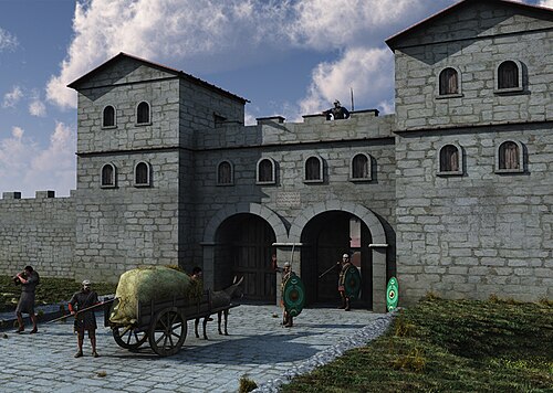
An artist's impression of the fort layout, with Hadrian's Wall in the background – it is not currently known whether it was attached to the fort or not. Later the medieval Newcastle Castle was built on the same hilltop site above the River Tyne.
An artist's impression of the fort's gatehouse GATEHOUSE4 prodYD.jpg
An artist's impression of the fort's gatehouse

Much of the fort remains buried underneath the medieval Castle Keep, which gave the city of Newcastle its name. Few excavations have taken place and there is little to see due to the castle and surrounding city centre buildings being built over the fort's layout. However, the fort's praetorium , principia and two granaries are known to be in the environs of the castle, and their outlines can be seen marked out in stone adjacent to the castle keep. The remains of an original milecastle were found behind the Newcastle Arts Centre, just off the A186 Westgate Road. The precise line of Hadrian's Wall in the vicinity of the fort has not been found, so it is not yet known for example if the fort was attached to the Wall, though they cannot have been far apart. [8]

Excavations around the castle keep and dredging of the Tyne yielded finds typical of Roman encampments. These include pottery shards, engravings, seven altar stones, around eleven building inscriptions (one recording possible restoration of a bath-house outside the fort) and more recently a stone dedicated to empress Julia Domna dated 213. [9] The collection is housed at the Great North Museum: Hancock in Newcastle. [10]

The altar stones and inscriptions suggest the gods worshipped included Jupiter (two altar-stones), mother goddesses, of which one relief shows three seated female figures, and Silvanus. Water-related gods such as Neptune and Oceanus' altars have also been recovered, probably worshipped because of the fort's proximity to the river. [1]

Some remains of the bridge were thought to have been discovered in 1872 during the construction of the Swing Bridge over the Tyne, but contemporary scholarship suggests the site of the bridge remains unknown, and none of its fabric has been discovered. [11] The length of the Roman bridge from bank to bank is estimated to have been 234 metres (768 ft). [1]

Recovered inscriptions may have adorned the bridge. Two large altars are thought to have stood to either side of the road on the bridge's central pier, while a monumental inscription is thought to have been erected on a small archway, also on the central pier, under which all traffic on the bridge had to pass. These two altar stones were dredged from the mud of the Tyne and are in remarkably good condition, which has led some scholars to believe they may have been ceremoniously dropped into the water from the bridge during some sort of dedication ceremony. They can now be seen in the Great North Museum. [12]

Two rare stone sarcophagi uncovered on the site of the former chapel are thought to have been used to bury members of a rich and powerful family from the fort of Pons Aelius. The body of a wealthy Roman was recovered alongside a silver hairpin. [13]

Garrison

A possible detachment of the Legio VI Victrix (The Sixth "Victorious" Legion) may have resided here, although they were probably only responsible for building or rebuilding the fort in stone. This is known from altar stones. It is also mentioned on a dedicatory inscription which recorded reinforcements from the German provinces for Legio VI along with the other two British legions II Augusta and XX Valeria. These supplementary troops were necessary to bolster the island's garrison after losses incurred around the year 150 when the northern tribes revolted, and may have arrived in the train of the governor Gnaeus Julius Verus circa 158, also mentioned on the stone. [1]

A dedication to emperor Hadrian's mother, Domitia Paulina, attests the presence of the Cohors Ulpia Traiana Cugernorum civium Romanorum (The Cohort of Ulpian Cugerni, Trajan's Own) as evidently being stationed at Pons Aelius at the beginning of the third century. [1]

The Notitia Dignitatum records the Cohors I Cornoviorum (The First Cohort of Cornovii) as being present at the fort in the beginning of the fifth century. These were raised from among the Cornovii tribe who inhabited Cheshire and Shropshire, and were the only native British unit known to have been stationed on Hadrian's Wall. [1]

A stone tablet was found on the south side of Hanover Square in Newcastle that records the work of Cohors I Thracum on the vallum, but it is thought unlikely that this unit was ever permanently stationed here. [1]

See also

Related Research Articles

<span class="mw-page-title-main">The Castle, Newcastle</span> 11th-century English castle

The Castle, Newcastle, or Newcastle Castle is a medieval fortification in Newcastle upon Tyne, England, built on the site of the fortress that gave the City of Newcastle its name. The most prominent remaining structures on the site are the Castle Keep, and the Black Gate, its fortified gatehouse.

<span class="mw-page-title-main">Housesteads Roman Fort</span> Roman fort in Northumberland, England

Housesteads Roman Fort was an auxiliary fort on Hadrian's Wall, at Housesteads, Northumberland, England. It is dramatically positioned on the end of the mile-long crag of the Whin Sill over which the Wall runs, overlooking sparsely populated hills. It was called the "grandest station" on the Wall and is one of the best-preserved and extensively displayed forts. It was occupied for almost 300 years. It was located 5.3 miles west from Carrawburgh fort, 6 miles east of Great Chesters fort and about two miles north east of the existing fort at Vindolanda on the Stanegate road.

<span class="mw-page-title-main">History of Newcastle upon Tyne</span> Development of a city in North East England

The history of Newcastle upon Tyne dates back almost 2,000 years, during which it has been controlled by the Romans, the Angles and the Norsemen amongst others. Newcastle upon Tyne was originally known by its Roman name Pons Aelius. The name "Newcastle" has been used since the Norman conquest of England. Due to its prime location on the River Tyne, the town developed greatly during the Middle Ages and it was to play a major role in the Industrial Revolution, being granted city status in 1882. Today, the city is a major retail, commercial and cultural centre.

<span class="mw-page-title-main">Segedunum</span> Roman fort in Tyne and Wear, England

Segedunum was a Roman fort at modern-day Wallsend, North Tyneside in North East England. The fort lay at the eastern end of Hadrian's Wall near the banks of the River Tyne. It was in use for approximately 300 years from around 122 AD to almost 400. Today Segedunum is the most thoroughly excavated fort along Hadrian's Wall, and is operated as Segedunum Roman Fort, Baths and Museum. It forms part of the Hadrian's Wall UNESCO World Heritage Site.

<span class="mw-page-title-main">Cilurnum</span> Roman cavalry fort on Hadrians wall

Cilurnum or Cilurvum was an ancient Roman fort on Hadrian's Wall at Chesters near the village of Walwick, Northumberland. It is also known as Walwick Chesters to distinguish it from Great Chesters fort and Halton Chesters.

<span class="mw-page-title-main">Carrawburgh</span> Settlement in Northumberland, England

Carrawburgh is a settlement in Northumberland. In Roman times, it was the site of a 3+12-acre (1.5 ha) auxiliary fort on Hadrian's Wall called Brocolitia, Procolita, or Brocolita.

<span class="mw-page-title-main">Vallum (Hadrian's Wall)</span> Earthwork associated with Hadrians Wall, England

The Vallum is a huge earthwork associated with Hadrian's Wall in England. Unique on any Roman frontier, it runs practically from coast to coast to the south of the wall. It was built a few years after the Wall.

<span class="mw-page-title-main">Vindomora</span> Roman auxiliary fort in County Durham, England

Vindomora was an auxiliary fort on Dere Street, in the province of Lower Britain. Its ruins, now known as Ebchester Roman Fort, are situated at Ebchester in the English county of Durham, to the north of Consett and 12 miles (19 km) west-south-west from Newcastle upon Tyne.

<span class="mw-page-title-main">Concangis</span> Roman fort in Duram, England

Concangis was an auxiliary castra in the Roman province of Lower Britain. Its ruins are located in Chester-le-Street, Durham, in England, and are now known as Chester-le-Street Roman Fort. It is situated 6 miles (10 km) north of Durham and 8 miles (13 km) south of Newcastle upon Tyne.

<span class="mw-page-title-main">Condercum</span> Roman fort in England

Condercum was a Roman fort on the site of the modern-day Condercum Estate in Benwell, a suburb of Newcastle upon Tyne, England. It was the third fort on Hadrian's Wall, about 6.8 miles east of Rudchester fort and only 2.4 miles west of Pons Aelius fort (Newcastle), and was situated on a hilltop 2 miles (3 km) to the west of the city.

<span class="mw-page-title-main">Milecastle 0</span>

Milecastle 0 is a possible milecastle of the Roman Hadrian's Wall which may have preexisted the fort of Segedunum. Although its existence has been suggested by historian Peter Hill, no evidence of this milecastle has been found. It is not known whether the decision to establish forts on the line of the wall predated the decision to extend the wall to Wallsend, so it is possible that this milecastle was never built.

<span class="mw-page-title-main">Aballava</span> Roman fort in Cumbria, England

Aballava or Aballaba was a Roman fort on Hadrian's Wall, between Petriana (Stanwix) to the east and Coggabata (Drumburgh) to the west. It is about one and a half miles south of the Solway Firth, and its purpose was to guard the south end of two important Solway fords, the Peat Wath and the Sandwath, which were also to become favourite routes for medieval border raiders.

<span class="mw-page-title-main">Hadrian's Wall</span> Defensive fortification in Roman Britain

Hadrian's Wall is a former defensive fortification of the Roman province of Britannia, begun in AD 122 in the reign of the Emperor Hadrian. Running from Wallsend on the River Tyne in the east to Bowness-on-Solway in the west of what is now northern England, it was a stone wall with large ditches in front of it and behind it that crossed the whole width of the island. Soldiers were garrisoned along the line of the wall in large forts, smaller milecastles, and intervening turrets. In addition to the wall's defensive military role, its gates may have been customs posts.

<span class="mw-page-title-main">Milecastle 6</span>

Milecastle 6 (Benwell Grove) was a milecastle of the Roman Hadrian's Wall.

<span class="mw-page-title-main">Milecastle 7</span> Milecastle of the Roman Hadrians Wall in United Kingdom

Milecastle 7 (Benwell Bank or Benwell Hill) was a milecastle of the Roman Hadrian's Wall. The milecastle itself has not been discovered by archaeologists and its presumed location lies beneath a modern housing development. Roman finds have been made in the area and the associated structure of Turret 7B is a significant surviving structure of the wall.

<span class="mw-page-title-main">Milecastle 13</span>

Milecastle 13 (Rudchester Burn) was a milecastle of the Roman Hadrian's Wall. Its remains exist as a low platform south of the B6318 Military Road.

<span class="mw-page-title-main">Milecastle 19</span>

Milecastle 19 (Matfen Piers) was a milecastle of the Roman Hadrian's Wall. Sited just to the east of the hamlet of Matfen Piers, the milecastle is today covered by the B6318 Military Road. The milecastle is notable for the discovery of an altar by Eric Birley in the 1930s. An inscription on the altar is one of the few dedications to a mother goddess found in Roman Britain, and was made by members of the First Cohort of Varduli from northern Spain. The presence of the Vardulians at this milecastle has led to debate amongst archaeologists over the origins of troops used to garrison the wall. A smaller altar was found at one of the two associated turrets.

<span class="mw-page-title-main">Milecastle 22</span>

Milecastle 22 (Portgate) was a milecastle of the Roman Hadrian's Wall. Its remains exist as a low, turf covered platform just east of the Portgate roundabout (junction of the A68 and B6318). The platform is 0.5 metres (1.6 ft) on the east side, reducing to only a parch mark on the west side.

<span class="mw-page-title-main">Milecastle 27</span>

Milecastle 27 (Low Brunton) was a milecastle of the Roman Hadrian's Wall. It was located on the line of Hadrian's Wall, approximately midway between the A6079 and the River North Tyne. Its remains survive as a slight squarish platform with a maximum height of 0.4 metres (1.3 ft), but it is poorly defined to the north and east.

<span class="mw-page-title-main">Milecastle 25</span>

Milecastle 25 (Codlawhill) was a milecastle of the Roman Hadrian's Wall. Its remains exist as a low platform, and are located to the south of the B6318 Military Road (about 1 metre (3.3 ft) high), nearly 5 kilometres (3.1 mi) to the west of its junction with the A68.

References

  1. 1 2 3 4 5 6 7 "Pons Aelius". Roman Britain. Archived from the original on 4 June 2018. Retrieved 29 April 2018.
  2. Whitney, Charles S. (1 January 2003). Bridges of the World: Their Design and Construction. Courier Corporation. p. 65. ISBN   978-0-486-42995-3.
  3. "Milecastle 4 to 7 via Condercum Fort". Hadrian's Wall. Retrieved 29 April 2018.
  4. Welcome to the Castle Keep, Newcastle Upon Tyne, UK. The Castle Keep Timeline Archived 23 December 2004 at the Wayback Machine
  5. Pons Aelius Brief History Archived 12 September 2006 at the Wayback Machine
  6. Middlebrook, Sydney (1950). Newcastle upon Tyne, Its Growth and Achievement. S R. ISBN   0-85409-523-3.
  7. "Roman and Anglo-Saxon". Newcastle Castle. Archived from the original on 28 June 2019. Retrieved 29 April 2018.
  8. "3D Animation Of Pons Aelius, The Ancient Newcastle Roman Fort, Presents A Flurry Of Details". Realm of History. Retrieved 29 April 2018.
  9. Archaeologia Aeliana - Fifth Series, Volume XXXI - The Roman Fort at Newcastle Upon Tyne published by The Society of Antiquaries of Newcastle upon Tyne 2002
  10. "Great North Museum: Hancock" . Retrieved 29 April 2018.
  11. Bidwell, Paul T; Holbrook, Neil (1989). Hadrian's Wall Bridges. Historic Buildings and Monuments Commission for England. ISBN   1-85074-166-2.
  12. Welcome to the Castle Keep, Newcastle Upon Tyne, UK. The Castle Keep Timeline Archived 22 December 2004 at the Wayback Machine
  13. "Durham University News : News - Durham University". www.dur.ac.uk. Retrieved 25 May 2018.

Further reading

54°58′7.7196″N1°36′35.9352″W / 54.968811000°N 1.609982000°W / 54.968811000; -1.609982000