Philip I, commonly known as Philip the Arab, was the Emperor of the Roman Empire from 244 to 249. After the death of Gordian III in February 244, Philip, who had been Praetorian prefect, rose to power. He quickly negotiated peace with the Sasanian Empire and returned to Rome to be confirmed by the Senate.
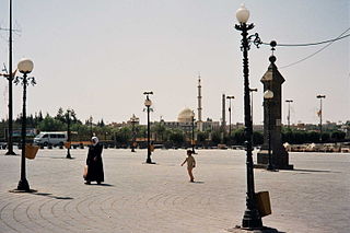
Bosra, formerly Bostra and officially called Busra al-Sham, is a town in southern Syria, administratively belonging to the Daraa District of the Daraa Governorate and geographically part of the Hauran region.

Arabia Petraea or Petrea, also known as Rome's Arabian Province or simply Arabia, was a frontier province of the Roman Empire beginning in the 2nd century. It consisted of the former Nabataean Kingdom in the southern Levant, the Sinai Peninsula, and the northwestern Arabian Peninsula. Its capital was Petra. It was bordered on the north by Syria, on the west by Judaea and Egypt, and on the south and east by the rest of Arabia, known as Arabia Deserta and Arabia Felix.

The Hauran is a region that spans parts of southern Syria and northern Jordan. It is bound in the north by the Ghouta oasis, eastwards by the al-Safa field, to the south by Jordan's desert steppe and to the west by the Golan Heights. Traditionally, the Hauran consists of three subregions: the Nuqrah and Jaydur plains, the Jabal al-Druze massif, and the Lajat volcanic field. The population of the Hauran is largely Arab, but religiously heterogeneous; most inhabitants of the plains are Sunni Muslims belonging to large agrarian clans, while Druze form the majority in the eponymous Jabal al-Druze and a significant Greek Orthodox and Greek Catholic minority inhabit the western foothills of Jabal al-Druze. The region's largest towns are Daraa, al-Ramtha and al-Suwayda.

Shahba (Arabic: شَهْبَا / ALA-LC: Shahbā) is a city located 87 km (54 mi) south of Damascus in the Jabal el Druze in As-Suwayda Governorate of Syria, but formerly in the Roman province of Arabia Petraea. Known in Late Antiquity as Philippopolis (in Arabia), the city was the seat of a Bishopric (see below), which remains a Latin titular see.

The Lajat, also spelled Lejat, Lajah, el-Leja or Laja, is the largest lava field in southern Syria, spanning some 900 square kilometers. Located about 50 kilometers (31 mi) southeast of Damascus, the Lajat borders the Hauran plain to the west and the foothills of Jabal al-Druze to the south. The average elevation is between 600 and 700 meters above sea level, with the highest volcanic cone being 1,159 meters above sea level. Receiving little annual rainfall, the Lajat is largely barren, though there are scattered patches of arable land in some of its depressions.
Umm el-Jimal, also rendered as Umm ej Jemāl, Umm al-Jimal or Umm idj-Djimal, is a village in northern Jordan approximately 17 kilometers east of Mafraq. It is primarily notable for the substantial ruins of a Byzantine and early Islamic town which are clearly visible above the ground, as well as an older Roman village located to the southwest of the Byzantine ruins.
Nawa is a city in Syria, administratively belonging to the Daraa Governorate. It has an altitude of 568 meters (1,864 ft). In 2007 it had a population of 59,170, making it the 28th largest city in Syria.

Fiq was a Syrian town in the Golan Heights that administratively belonged to Quneitra Governorate. It sat at an altitude of 349 meters (1,145 ft) and had a population of 2,800 in 1967. It was the administrative center of the Fiq District, the southern district of the Golan. Fiq was evacuated during and after the Six-Day War in June 1967. The Israeli settlement of Kibbutz Afik was built close by.

Izra or Izraa is a town in the Daraa Governorate of Syria, to the north of the city of Daraa. It is the administrative centre of the Izra District, and sits at an altitude of 599 metres. Izra had a population of 19,158 in 2004, according to the Syria Central Bureau of Statistics (CBS).

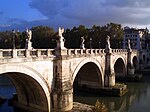
The Bridge of Gemarrin is a Roman bridge in the village of Jemarrin near the ancient city of Bosra in southern Syria. The bridge belonged to the Roman road to Soada Dionysias (As-Suwayda), crossing the Wadi Zeidi some kilometers north of Bostra.
The Kharaba Bridge is a Roman bridge in the village of Kharaba in the fertile Hauran region of Syria, close to the city of Bosra.
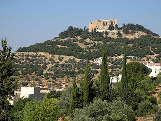
Ajloun Castle, medieval name Qalʻat ar-Rabad, is a 12th-century Muslim castle situated in northwestern Jordan. It is placed on a hilltop belonging to the Mount Ajloun district, also known as Jabal Auf after a Bedouin tribe which had captured the area in the 12th century. From its high ground the castle was guarding three wadis which descend towards the Jordan Valley. It was built by the Ayyubids in the 12th century and enlarged by the Mamluks in the 13th.

The Namara inscription is a 4th century inscription in the Arabic language, making it one of the earliest. It has also been interpreted as a late version of the Nabataean script in its transition to Arabic script. It has been described by Irfan Shahid as "the most important Arabic inscription of pre-Islamic times" and by Kees Versteegh as "the most famous Arabic inscription". It is also an important source for the relationships between the Romans and the Arabs in that period. It is currently on display at the Louvre Museum in France, with identification number AO 4083.

Transjordan, also known as the East Bank or the Transjordanian Highlands, is the part of the Southern Levant east of the Jordan River, mostly contained in present-day Jordan.

Al-Masmiyah is a town in southern Syria, administratively part of the Daraa Governorate, located northeast of Daraa in the al-Sanamayn District. Nearby localities include Jabab and Muthabin to the west, Ghabaghib to the northeast, Jubb al-Safa to the north, Burraq to the northeast, Khalkhalah and al-Surah al-Saghirah to the southeast and Dama to the south.

Philippopolis is one of the names of the ancient city situated where Plovdiv is today. The city became one of the largest and most important in the region and was called "the largest and most beautiful of all cities" by Lucian. During most of its recorded history, the city was known by the name Philippopolis after Philip II of Macedon. Philippopolis became part of the Roman empire and capital of the Roman province of Thracia. According to Ammianus Marcellinus, Philippopolis had a population of 100,000 in the Roman period.

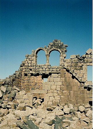
A kalybe is a type of temple found in the eastern Roman Empire dating from the 1st century and after. They were intended to serve as a "public facade or stage-setting, solely for the display of statuary." "[T]hey were essentially stage-sets for ritual enacted in front of them." The kalybe has been associated with the Roman imperial cult.