Knag Burn Gateway

Last updated

Knag Burn Gateway
Northumberland, England, UK
Knag Burn Gateway on Hadrian's Wall - geograph.org.uk - 499989.jpg
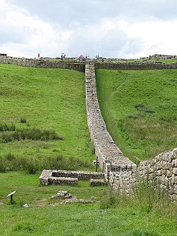
Remains of the Knag Burn Gateway taken from South of the wall facing West towards Housesteads (visible at the top of the hill)
Hadrian's Wall at the Knag Burn northeast of Housesteads Fort - geograph.org.uk - 1495123.jpg
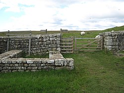
The remains of the gateway
Northumberland UK location map.svg
Red pog.svg
Knag Burn Gateway
Location in Northumberland
Coordinates 55°00′53″N2°19′43″W / 55.01466°N 2.32865°W / 55.01466; -2.32865 Coordinates: 55°00′53″N2°19′43″W / 55.01466°N 2.32865°W / 55.01466; -2.32865
Grid reference NY79086894

The Knag Burn Gateway is a gateway which was built into Hadrian's Wall some time after construction of the wall itself, generally acknowledged to be during the fourth century. [1]

Contents

Location

Knag Burn Gateway is located at the point where Hadrian's Wall crosses the Knag Burn, just to the east of Housesteads, between the fort and Turret 36B. The burn itself passes beneath the wall via a culvert a few metres to the West of the gateway.

Description

Knag Burn Gateway is one of the few gates through the wall that isn't part of a milecastle or fort. [1] The remains indicate that the structure consisted of a single-lane gateway, with guard-chambers on either side and a gate at each end, thus allowing two-stage controlled passage through the wall. [2] Professor I. A. Richmond suggested that the gateway was constructed to allow trade traffic through the wall some time in or after the fourth century. [3]

The gateway was discovered in 1855 and excavated in 1936 and 1988. The structure consists of the 3.7 metres (12 ft) wide gateway with two small structures either side. [4]

The two cell structures at either side of the gateway measure 4.65 metres (15.3 ft) by 3.25 metres (10.7 ft), with entrances 0.95 metres (3 ft 1 in) wide (on the side nearest the gateway), which open onto a passage. [4]

Monument record

MonumentMonument Number English Heritage Archive NumberScheduled Monument Notification
Knag Burn Gateway1007856NY 76 NE 9514-July-1997

Related Research Articles

Milecastle 4

Milecastle 4 was a milecastle of the Roman Hadrian's Wall. Its remains exist beneath the Newcastle Arts Centre at 67-75 Westgate Road. This position is some way away from its predicted position which is at these coordinates: 54.970440°N 1.608669°W The actual location is between the predicted positions of Turrets 4A and 4B, which has led to suggestions that the numbering and positioning of milecastles and turrets on this part of Hadrian's Wall should be reconsidered.

Milecastle 18

Milecastle 18 was a milecastle of the Roman Hadrian's Wall. It is located to the west of the settlement of East Wallhouses in Northumberland and is visible as a platform in the ground. The milecastle is of a unique construction, having a gateway associated with builders of the Legio II Augusta and a layout typical of the Legio VI Victrix or Legio XX Valeria Victrix. Historians have suggested that it may have been begun by men of one legion and finished by those of another. One of Milecastle 18's associated turrets shows evidence of being used as a workshop, possibly for the repair of shoes.

Vindobala Roman fort at Northumberland, England

Vindobala was a Roman fort at the modern-day hamlet of Rudchester, Northumberland. It was the fourth fort on Hadrian's Wall, after Segedunum (Wallsend), Pons Aelius (Newcastle) and Condercum (Benwell). It was situated about 11 kilometres (6.8 mi) to the west of Condercum. The site of the fort is bisected by the B6318 Military Road, which runs along the route of the wall at that point.

Milecastle 13

Milecastle 13 was a milecastle of the Roman Hadrian's Wall. Its remains exist as a low platform south of the B6318 Military Road.

Milecastle 14

Milecastle 14 was a milecastle of the Roman Hadrian's Wall. Its remains exist as a low platform, south of the B6318 Military Road and about 1 kilometre (0.62 mi) to the west of the road junction at Rudchester Farm.

Milecastle 15

Milecastle 15 (Whitchester) was a milecastle of the Roman Hadrian's Wall. Its remains exist as a bold platform with robbed walls located on the southern side of the B6318 Military Road approximately 3 kilometres (1.9 mi) west of its crossing of the A69 road. It has not been excavated.

Milecastle 19

Milecastle 19 was a milecastle of the Roman Hadrian's Wall. Sited just to the east of the hamlet of Matfen Piers, the milecastle is today covered by the B6318 Military Road. The milecastle is notable for the discovery of an altar by Eric Birley in the 1930s. An inscription on the altar is one of the few dedications to a mother goddess found in Roman Britain, and was made by members of the First Cohort of Varduli from northern Spain. The presence of the Vardulians at this milecastle has led to debate amongst archaeologists over the origins of troops used to garrison the wall. A smaller altar was found at one of the two associated turrets.

Milecastle 22

Milecastle 22 (Portgate) was a milecastle of the Roman Hadrian's Wall. Its remains exist as a low, turf covered platform just east of the Portgate roundabout. The platform is 0.5 metres (1.6 ft) on the east side, reducing to only a parch mark on the west side.

Milecastle 23

Milecastle 23 (Stanley) was a milecastle of the Roman Hadrian's Wall. Its remains exist as a low, grass covered platform with traces of an external ditch. It is located to the south of the B6318 Military Road around 1.5 kilometres (0.93 mi) west of its junction with the A68.

Pike Hill Signal Tower

Pike Hill Signal Tower was one of a number of signal stations that were built on high ground overlooking the line of the Roman Stanegate road in northern Britannia during the early 2nd century. It later became incorporated into Hadrian's Wall. Its remains, a 2-metre long fragment of the south-east wall, lie south of a modern road cutting and field wall, and are located in the parish of Waterhead in Cumbria, United Kingdom. The tower is located between Turret 51B and Turret 52A with the fort of Banna located to the east.

Milecastle 27

Milecastle 27 was a milecastle of the Roman Hadrian's Wall. It was located on the line of Hadrian's Wall, approximately midway between the A6079 and the River North Tyne. Its remains survive as a slight squarish platform with a maximum height of 0.4 metres (1.3 ft), but it is poorly defined to the north and east.

Milefortlet 21

Milefortlet 21 was a Milefortlet of the Roman Cumbrian Coast defences. These defences were contemporary with defensive structures on Hadrian's Wall. Its remains exist as reconstructed turf ramparts and ditch, reinstated to its original profile. They are located on a low cliff on the coast, north of the village of Crosscanonby, and just inland from the coastal road. It is the only milefortlet to have been fully excavated and is open to the public.

Milecastle 25

Milecastle 25 (Codlawhill) was a milecastle of the Roman Hadrian's Wall. Its remains exist as a low platform, and are located to the south of the B6318 Military Road, nearly 5 kilometres (3.1 mi) to the west of its junction with the A68.

Milecastle 26

Milecastle 26 (Planetrees) was a milecastle of the Roman Hadrian's Wall. Its position is slightly to the south of, but mostly covered by the B6318 Military Road., and it is located around 700 metres (0.43 mi) east of the B6318 Military Road's junction with the A6079. No visible traces exist currently. The dimensions are the same as Milecastles 23, 24, and 25.

Portgate

The Portgate was a fortified gateway, constructed as part of Hadrian's Wall where it crossed the Roman road now known as Dere Street, which preceded Hadrian's Wall by around 50 years. It was built to control traffic along Dere Street as it passed north through Hadrian's Wall. The gate's remains exist beneath the old B6318 Military Road to the south-west of the Stagshaw Roundabout.

Milecastle 29

Milecastle 29 was a milecastle of the Roman Hadrian's Wall. Its remains exist as a mutilated earth platform accentuated by deep robber-trenches around all sides, and are located beside the B6318 Military Road. Like Milecastles 9, 23, 25, and 51, a ditch has been identified around the Milecastle, and is still visible to a small extent. It has been postulated that this was as a result of the need for drainage on the site.

Milecastle 30

Milecastle 30 was a milecastle of the Roman Hadrian's Wall. Its remains exist as an outward-facing scarp with a maximum height of 0.8 metres (2.6 ft). Masonry from the east wall remains in situ. The remaining stretch is 3.1 metres (10 ft) in length by 2.25 metres (7.4 ft) thick, and survives to a height of 0.6 metres (2.0 ft). It is located at the western part of Limestone Corner, just off the B6318 Military Road.

Milecastle 33

Milecastle 33 was a milecastle of the Roman Hadrian's Wall, one of a series of small fortlets built at intervals of approximately one Roman mile along the length of the UNESCO World Heritage Site in northern England.

Milecastle 34

Milecastle 34 (Grindon) was a milecastle of the Roman Hadrian's Wall. There are no visible remains, but the site is within a small, tree-filled, walled enclosure located around 0.5 kilometres (0.31 mi) east of Sewingshields farm.

Milecastle 50TW

Milecastle 50TW was a milecastle on the Turf Wall section of Hadrian's Wall. The milecastle is located close to the Birdoswald Roman Fort and is unique in that it was not replaced by a stone milecastle when the turf wall was upgraded to stone, the replacement wall instead running some 200m to the north. The milecastle was partially demolished by the Romans after it was abandoned. The milecastle was excavated in 1934 and several Roman rubbish pits discovered. The remains of the two turrets associated with this milecastle have also been located. As the turf wall lies some distance from the stone wall, the sites are not accessible from the Hadrian's Wall Path.

References

  1. 1 2 Breeze, David J (1934), Handbook to the Roman Wall (14th Revised edition - Nov 2006), Society of Antiquaries of Newcastle upon Tyne, ISBN   0-901082-65-1
  2. David J Breeze and Brian Dobson (1976). Hadrian's Wall. Allen Lane. ISBN   0-14-027182-1.
  3. Toynbee, J. M. C. (June 1960). "Review: The Impact of Roman on Native in North Britain". The Classical Review. Cambridge University Press. 10 (2): 164–166. doi:10.1017/s0009840x0017074x.
  4. 1 2 "Knag Burn Gateway". Pastscape. English Heritage. Retrieved 11 May 2010.