There are many Roman sites in Great Britain that are open to the public. There are also many sites that do not require special access, including Roman roads, and sites that have not been uncovered.
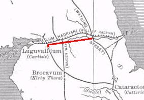
The Stanegate was an important Roman road and early frontier built in what is now northern England. It linked many forts including two that guarded important river crossings: Corstopitum (Corbridge) on the River Tyne in the east and Luguvalium (Carlisle) in the west. The Stanegate ran through the natural gap formed by the valleys of the River Tyne in Northumberland and the River Irthing in Cumbria. It predated the Hadrian's Wall frontier by several decades; the Wall would later follow a similar route, albeit slightly to the north.

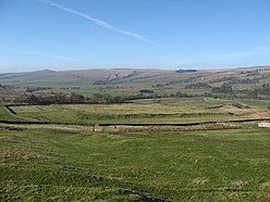
Trimontium was a Roman fort complex located at Newstead, near Melrose, in the Scottish Borders, in view of the three Eildon Hills which probably gave its name.
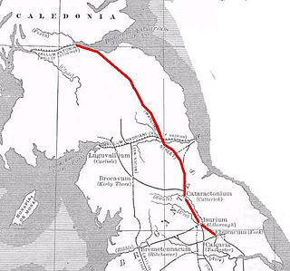
Dere Street or Deere Street is a modern designation of a Roman road which ran north from Eboracum (York), crossing the Stanegate at Corbridge and continuing beyond into what is now Scotland, later at least as far as the Antonine Wall. It was the Romans' major route for communications and supplies to the north and to Scotland. Portions of its route are still followed by modern roads, including the A1(M), the B6275 road through Piercebridge, where Dere Street crosses the River Tees, and the A68 north of Corbridge in Northumberland.

Segedunum was a Roman fort at modern-day Wallsend, North Tyneside in North East England. The fort lay at the eastern end of Hadrian's Wall near the banks of the River Tyne, forming the easternmost portion of the wall. It was in use as a garrison for approximately 300 years, from around 122 AD, almost up to 400 AD. Today, Segedunum is the most thoroughly excavated fort along Hadrian's Wall, and is operated as Segedunum Roman Fort, Baths and Museum. It forms part of the Hadrian's Wall UNESCO World Heritage Site.

Bremenium is an ancient Roman fort (castrum) located at Rochester, Northumberland, England. The fort is part of the defensive system built along the extension of Dere Street, a Roman road running from York to Corbridge and onwards to Melrose. Significantly the fort is a long way north of Hadrian's Wall. It was one of the last forts north of Hadrian's wall to remain occupied until the 270s.

Magnis or Magna was a Roman fort near Hadrian's Wall in northern Britain. Its ruins are now known as Carvoran Roman Fort and are located near Carvoran, Northumberland, in northern England. It was built on the Stanegate frontier and Roman road, before the building of Hadrian's Wall.

Coria was a fort and town 2.5 miles (4.0 km) south of Hadrian's Wall, in the Roman province of Britannia on the junction of a major Roman north–south road with the River Tyne and another Roman road (Stanegate), which ran east–west between Coria and Luguvalium. Corbridge Roman Site is in the village of Corbridge in the county of Northumberland.

Longovicium was an auxiliary fort located on Roman Dere Street, in the Roman province of Britannia Inferior. It is located just southwest of Lanchester in the English county of Durham, roughly 8 miles (13 km) to the west of the city of Durham and 5 miles (8 km) from Consett.
Vindomora was an auxiliary fort on Dere Street, in the province of Lower Britain. Its ruins, now known as Ebchester Roman Fort, are situated at Ebchester in the English county of Durham, to the north of Consett and 12 miles (19 km) west-south-west from Newcastle upon Tyne.

Condercum was a Roman fort on the site of the modern-day Condercum Estate in Benwell, a suburb of Newcastle upon Tyne, England. It was the third fort on Hadrian's Wall, after Segedunum (Wallsend) and Pons Aelius (Newcastle), and was situated on a hilltop 2 miles (3 km) to the west of the city.

Hunnum was a Roman fort on Hadrian's Wall located north of the modern-day village of Halton, Northumberland in North East England. It was the fifth fort on Hadrian's Wall, after Segedunum (Wallsend), Pons Aelius (Newcastle), Condercum and Vindobala. The fort may also have guarded Dere Street which crosses the Roman Wall through the valley immediately to the west. It is situated about 7.5 miles west of Vindobala, and 2.5 miles north of Corstopitum. The site of the fort is bisected by the B6318 Military Road, which runs along the route of the wall at that point.

Aesica was a Roman fort, one and a half miles north of the small town of Haltwhistle in Northumberland, England. It was the ninth fort on Hadrian's Wall, between Vercovicium (Housesteads) to the east and Banna (Birdoswald) 6.5 miles to the west. Its purpose was to guard the Caw Gap, where the Haltwhistle Burn crosses the Wall. The B6318 Military Road passes about half a mile to the south of the fort.
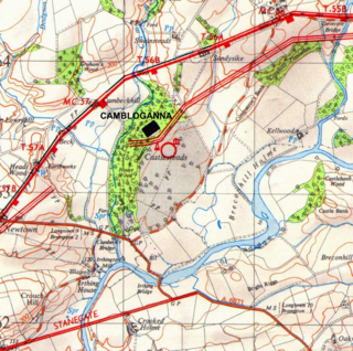
Camboglanna was a Roman fort. It was the twelfth fort on Hadrian's Wall counting from the east, between Banna (Birdoswald) almost 7 miles (11 km) to the east and Uxelodunum (Stanwix), 9 miles to the west. It was on a high bluff commanding the Cambeck Valley. It guarded an important approach to the Wall and also watched the east bank of the Cambeck against raiders from the Bewcastle area. The site was drastically levelled in 1791 when the gardens of Castlesteads House were laid over it. The name "Camboglanna" is believed to mean "Crook Bank", or "Bent Valley" because it overlooks a bend in the river Irthing; the name is Brythonic, made of cambo- "curved, bent, crooked" and glanna "steep bank, stream/river side, valley with a stream".
Maia, or Mais, in Cumbria, England was a Roman fort on Hadrian's Wall, and was the last fort at the western end of the Wall, overlooking the Solway Firth.

Bewcastle Roman Fort was built to the north of Hadrian's Wall as an outpost fort possibly intended for scouting and intelligence. The remains of the fort are situated at the village of Bewcastle, Cumbria, 7 miles (11 km) to the north of the Roman fort at Birdoswald, on Hadrian's Wall.

The Antonine Wall, known to the Romans as Vallum Antonini, was a turf fortification on stone foundations, built by the Romans across what is now the Central Belt of Scotland, between the Firth of Clyde and the Firth of Forth. Built some twenty years after Hadrian's Wall to the south, and intended to supersede it, while it was garrisoned it was the northernmost frontier barrier of the Roman Empire. It spanned approximately 63 kilometres and was about 3 metres high and 5 metres wide. Lidar scans have been carried out to establish the length of the wall and the Roman distance units used. Security was bolstered by a deep ditch on the northern side. It is thought that there was a wooden palisade on top of the turf. The barrier was the second of two "great walls" created by the Romans in Great Britain in the second century AD. Its ruins are less evident than those of the better-known and longer Hadrian's Wall to the south, primarily because the turf and wood wall has largely weathered away, unlike its stone-built southern predecessor.
Cataractonium was a fort and settlement in Roman Britain. The settlement evolved into Catterick, located in North Yorkshire, England.

Milecastle 19 (Matfen Piers) was a milecastle of the Roman Hadrian's Wall. Sited just to the east of the hamlet of Matfen Piers, the milecastle is today covered by the B6318 Military Road. The milecastle is notable for the discovery of an altar by Eric Birley in the 1930s. An inscription on the altar is one of the few dedications to a mother goddess found in Roman Britain, and was made by members of the First Cohort of Varduli from northern Spain. The presence of the Vardulians at this milecastle has led to debate amongst archaeologists over the origins of troops used to garrison the wall. A smaller altar was found at one of the two associated turrets.
Cohors Primae Vangionum Milliaria Equitata was a Roman auxiliary infantry cohort from Upper Germany with both horse and foot soldiers known as a cohors equitata, and nominally 1000 strong.