Milecastle 35

Last updated

Milecastle 35
Milecastle 35 - geograph.org.uk - 472634.jpg
Consolidated remains of Milecastle 35
Northumberland UK location map.svg
Red pog.svg
Location within Northumberland
TypeMilecastle
Location
Coordinates 55°01′33″N2°18′24″W / 55.025812°N 2.306637°W / 55.025812; -2.306637 Coordinates: 55°01′33″N2°18′24″W / 55.025812°N 2.306637°W / 55.025812; -2.306637
CountyNorthumberland
CountryEngland
Reference
UK-OSNG reference NY80497018

Milecastle 35 (Sewingshields) is one of the milecastles on Hadrian's Wall (grid reference NY80497018 ). The remains still exist as exposed masonry.

Contents

Description

The remains of Milecastle 35 are on the east-facing slope of Sewingshields Crags and survive as stone foundations. The milecastle measures 18.3 metres by 15.2 metres internally and its walls are up to 3.2 metres wide. [1] A Roman branch road running south from Milecastle 35 to join the Military Way survives as a low agger up to 5.5 metres wide and up to 20 centimetres high. [2]

Construction

Milecastle 35 was a long-axis milecastle with a Type IV gateway (south gate). [1]

Excavations

Milecastle 35 was excavated in 1947 and again between 1978 and 1980 (with an additional week in 1982). [1] Several phases of internal buildings were detected. Phase I consisted of a small building 4.25 metres by 7.45 metres with stone footings. [1] Phase II, probably dating to the late 2nd or early 3rd century, consisted of a new buildings on the east and west side. The site then fell into disrepair. [1] Phase III consisted of new buildings, somewhat crudely constructed, with considerable industrial activity. [1] Phase IV consisted of some new stone footings placed over previous metal-working areas. [1]

The site was reoccupied in the late medieval period (13th to 16th century), when two substantial longhouse buildings were built. [3] The medieval remains were removed during excavations. [3]

Associated turrets

Remains of Turret 35A Turret west of Milecastle 35 - geograph.org.uk - 472635.jpg
Remains of Turret 35A
Approximate site of Turret 35B Heading uphill to Sewingshield Crags - geograph.org.uk - 2888921.jpg
Approximate site of Turret 35B

Each milecastle on Hadrian's Wall had two associated turret structures. These turrets were positioned approximately one-third and two-thirds of a Roman mile to the west of the Milecastle, and would probably have been manned by part of the nearest milecastle's garrison. The turrets associated with Milecastle 35 are known as Turret 35A and Turret 35B.

Turret 35A

Turret 35A (Sewingshields Crag) (grid reference NY80087008 ) exists as a consolidated structure. [4] The turret measures 3.7 metres by 2.4 metres internally, and the walls are up to 0.75 metres high. [4] It was excavated in 1958. [4] A rough inscribed slab was found 19 metres east of the Turret in the 1958 excavations. [4] [5]

Turret 35B

Turret 35B (Busy Gap) (grid reference NY79906973 ) is at the top of the ridge before the descent into Busy Gap. [6] It was located in 1913 and excavated in 1946. [6] The excavations showed that the turret had narrow walls and a door to the east. [6] There are no visible remains above ground except for an earthwork platform measuring 3.8 metres by 5.5 metres and up to 0.5 metres high. [6]

Monument records

MonumentMonument Number English Heritage Archive Number
Milecastle 3516829NY 87 SW 10
Medieval buildings938892NY 87 SW 34
Turret 35A16832NY 87 SW 11
Inscribed slab952053NY 87 SW 36
Turret 35B15134NY 76 NE 1

Public access

The milecastle, Turret 35A, and the site of Turret 35B, are all accessible via the Hadrian's Wall Path.

Related Research Articles

Milecastle 48

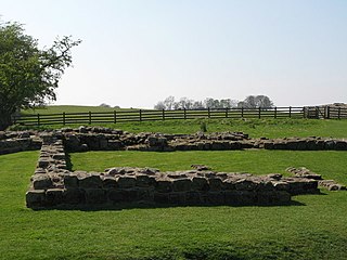
Milecastle 48 , is a milecastle on Hadrian's Wall. Its remains lie near the village of Gilsland in Cumbria where it was historically known as "The King's Stables", owing to the well-preserved interior walls. Unusually a substantial section of stone stairs has survived within the milecastle. The two turrets associated with this milecastle have also survived as above-ground masonry.

Milecastle 49

Milecastle 49 was a milecastle on Hadrian's Wall.

Milecastle 50

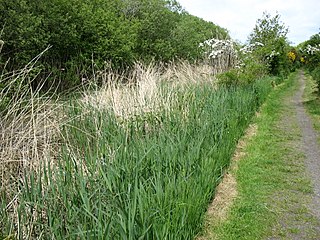
Milecastle 50 was a milecastle on Hadrian's Wall.

Milecastle 51

Milecastle 51 was a milecastle on Hadrian's Wall.

Milecastle 52

Milecastle 52 (Bankshead) was a milecastle on Hadrian's Wall.

Milecastle 53

Milecastle 53 was a milecastle on Hadrian's Wall.

Milecastle 39

Milecastle 39 is a milecastle on Hadrian's Wall.

Milecastle 38

Milecastle 38 (Hotbank) was a milecastle on Hadrian's Wall in the vicinity of Hotbank Farm,. It is notable for the joint inscription bearing the names of the emperor Hadrian and Aulus Platorius Nepos, the governor of Brittania at the time the Wall was built.

Milecastle 19

Milecastle 19 was a milecastle of the Roman Hadrian's Wall. Sited just to the east of the hamlet of Matfen Piers, the milecastle is today covered by the B6318 Military Road. The milecastle is notable for the discovery of an altar by Eric Birley in the 1930s. An inscription on the altar is one of the few dedications to a mother goddess found in Roman Britain, and was made by members of the First Cohort of Varduli from northern Spain. The presence of the Vardulians at this milecastle has led to debate amongst archaeologists over the origins of troops used to garrison the wall. A smaller altar was found at one of the two associated turrets.

Milecastle 79

Milecastle 79 was one of a series of Milecastles or small fortlets built at intervals of approximately one Roman mile along Hadrian's Wall.

Milecastle 78

Milecastle 78 (Kirkland) was one of a series of Milecastles or small fortlets built at intervals of approximately one Roman mile along Hadrian's Wall.

Milecastle 42

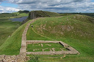
Milecastle 42 (Cawfields) is a milecastle on Hadrian's Wall.

Milecastle 47

Milecastle 47 was a milecastle on Hadrian's Wall.

Milecastle 32

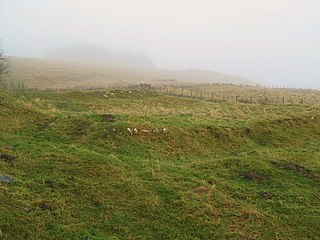
Milecastle 32 (Carraw) was a milecastle of the Roman Hadrian's Wall. Its remains exist as earthworks and with no exposed masonry. The layout of the milecastle walls is defined by robber trenches (to a maximum depth of 0.3 metres. The north wall is beneath a modern wall.

Milecastle 34

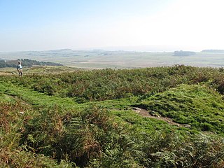
Milecastle 34 (Grindon) was a milecastle of the Roman Hadrian's Wall. There are no visible remains, but the site is within a small, tree-filled, walled enclosure located around 0.5 kilometres (0.31 mi) east of Sewingshields farm.

Milecastle 44

Milecastle 44 (Allolee) was a milecastle on Hadrian's Wall.

Milecastle 37

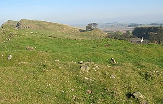
Milecastle 37 is one of the milecastles on Hadrian's Wall. It is immediately west of the Housesteads Roman Fort.

Milecastle 36

Milecastle 36 was one of the milecastles on Hadrian's Wall. There is little to see on the ground as most of the walls have been robbed and quarried away.

Milecastle 45

Milecastle 45 (Walltown) was a milecastle on Hadrian's Wall.

Milecastle 54

Milecastle 54 (Randylands) was a milecastle on Hadrian's Wall.

References

  1. 1 2 3 4 5 6 7 MILECASTLE 35, Pastscape, retrieved 27 November 2013
  2. MONUMENT NO. 951794, Pastscape, retrieved 3 December 2013
  3. 1 2 MONUMENT NO. 938892, Pastscape, retrieved 27 November 2013
  4. 1 2 3 4 TURRET 35A, Pastscape, retrieved 27 November 2013
  5. MONUMENT NO. 952053, Pastscape, retrieved 3 December 2013
  6. 1 2 3 4 TURRET 35B, Pastscape, retrieved 27 November 2013

Commons-logo.svg Media related to Milecastle 35 at Wikimedia Commons