Luguvalium

Last updated

Luguvalium (or Luguvalium Carvetiorum) was an ancient Roman city in northern Britain located within present-day Carlisle, Cumbria, and may have been the capital of the 4th-century province of Valentia. It was the northernmost city of the Roman Empire.

Contents

Location

Roman roads, forts and towns around Luguvalium Roman Carlisle.png
Roman roads, forts and towns around Luguvalium

The city was located on a crossroads of major Roman north-south and east-west roads and situated near to the Roman frontier, first defined by the Stanegate road and then by Hadrian's Wall, leading to Luguvalium’s development as a supply base and major military and commercial centre. [1] It also protected a strategic location and trade route overlooking the confluence of the Caldew and Eden rivers. [2]

Today the Roman city is located mainly under the modern city of Carlisle, but the Roman fort around which the settlement developed is mainly beneath the grounds of the later Carlisle Castle.

Name

The Romans called the settlement Luguvalium [3] which is now explained as a borrowed Brittonic placename reconstructed as *Luguwalion, meaning "[city] of Luguwalos", Luguwalos being a masculine Celtic given name meaning "strength of Lugus". [4] The name apparently continued in use among Brythonic speakers in the Hen Ogledd and Wales and it was during that time that the initial element caer ("fort") was added. The place is mentioned in Welsh sources such as Nennius, who calls it Cair Ligualid, [5] and the Book of Taliesin where it is rendered Caer Liwelyδ [6] (Modern Welsh Caerliwelydd). (These derived from the original Brittonic name, rather than from its Latin form. [4] ) The earliest record of the place in English is as Luel (c.1050); [7] later medieval forms include Cardeol, Karlioli, and Cærleoil. These appear to suggest that the northern form of the name did not have the final -ydd. (Compare the River Derwent in Cumbria with Derwenydd in Wales, both from Brittonic *Derwentjū.)
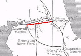
History

Map of fort (red) and vicus or civilian settlement (green) of Luguvalium Carvetiorum Befundskizze Luguvalium Carvetiorum (GB).png
Map of fort (red) and vicus or civilian settlement (green) of Luguvalium Carvetiorum
The Stanegate road and frontier; the road continued west of Carlisle to Kirkbride. Stanegate.jpg
The Stanegate road and frontier; the road continued west of Carlisle to Kirkbride.

Prehistoric

There are limited remains of a settlement during the British Iron Age. Before the Romans, the chief city of the Carvetii seems to have been Clifton Dykes.

Roman

Following their earlier conquest of the southern part of Britain, and Boudica's revolt, the Roman armies began to conquer the north and erected a timber fort around 72 AD at a key point south of the River Eden in a loop protected on two sides by water, on the site of the later Carlisle Castle. This fort later became the nucleus of the important Roman town of Luguvalium which grew up outside it. The fort was built by a vexillation of the legion Legio IX Hispana during the final campaign of Cerialis against the Brigantian Venutius. [8]

The fort was refurbished in 83 using oak timbers from further afield, rather than local alder, [9] indicating the greater Roman control of the area, and was garrisoned by a 500-strong cavalry regiment, the Ala Gallorum Sebosiana. [10] [2]

The 'Stanegate' frontier established from about 87 [11] which consisted of Luguvalium and several other forts on the road east to Corbridge, was proving a more stable frontier against the Picts than those established deeper into Caledonia. By the early 2nd century, Carlisle was established as a prominent stronghold. The fort was deliberately demolished around 103 but rebuilt before 105 and retained its garrison until the Hadrianic period. One of the Vindolanda tablets records a centurio regionarius, a Stanegate officer, stationed at Luguvalium in 103.

In 122 the province was visited by Hadrian who approved a plan to build a wall along the frontier slightly to the north of the Stanegate. A new large fort, Uxelodunum, was built therefore on the wall in the Stanwix area of Carlisle north of the river and within sight of the Luguvalium fort and became the largest fort along the length of Hadrian's Wall. [12] Uxellodunum was abandoned like the rest of the wall when the Antonine wall was built in 142-144, but was rebuilt in stone in about 165 when Hadrian's Wall was reinstated as the frontier. [13] Uxelodunum housed a nominal 1,000-strong cavalry regiment, the Ala Gallorum Petriana , [14] the sole regiment of this size along the wall. Milecastle 65 was also built on the wall about 1km northwest of the fort.

The garrison of the Luguvalium fort was only gradually reduced from 105 until the site was finally levelled and abandoned during the Antonine period (138-161). The fort was rebuilt in stone in about 200 by the Legio XX Valeria Victrix based at York. [15] Timber structures further to the south-east were probably associated military buildings and were also later replaced in stone by soldiers from the 20th legion. [16] The fort was finally abandoned sometime between 275-325. [17]

The civilian settlement ( vicus ) that developed outside the fort probably became the civitas capital of the Carvetii tribe some time in the 2nd century. [18] It was eventually enclosed by a stone wall assumed to have followed the line of the later medieval wall. Industry in the town included copper working and tanning, while merchants are also in evidence. Inscriptions show there was a Mithraeum in the town and possibly a temple to Mars, [19] who was identified with the local deity Belatucadros.

The town was listed in the Roman Antonine Itinerary (from beginning of the 3rd century).

Coins excavated in the area suggest that Romans remained in Carlisle until the reign of Emperor Valentinian II, from 375 to 392.

Medieval

Romano-British occupation of Luguvalium seems to have continued unbroken after the Roman withdrawal from Britain around 410. Possible 5th-century buildings have been identified during excavation, and the settlement has been identified as the court of Urien Rheged's kingdom. [5] Saint Cuthbert visited the town in the 7th century and, according to Bede, described the high stone walls and an impressive fountain, presumably fed by a still-functioning aqueduct. [20] The place was under the control of a praepositus civitatis.[ clarification needed ]

Cair Ligualid was listed among the 28 cities of Britain in Nennius (composed after 830). [21]

Excavations

Excavations in the 1950s identified the site of the fort of Luguvalium to the south of the present medieval Carlisle Castle, which lies over the north-eastern corner of the Roman fort. More recent excavations revealed the well-preserved timber structure of the Roman gatehouse and its adjoining rampart.

Three large marching camps near to Carlisle at Plumpton Head, Crackenthorpe and Rey Cross have all been attributed to the campaigns of governor Cerialis and dated sometime around 72/73AD. Tiles and pottery with stamps of the Legio IX Hispana (the fabled "Ninth Legion") have also been found at Scalesceugh 8km south of Carlisle, which indicates that a vexillation was probably involved with the early presence at Carlisle.

Excavations in 1981-84 and 1990 discovered around 50 wooden writing tablets within the Roman fort, containing unique evidence for the cavalry regiment, the ala Gallorum Sebosiana, and its consumption of barley, wheat and weapons. [22] The collection is second in importance only to that from Vindolanda.

In 2017 imperial baths larger than any found near Hadrian's Wall, and possibly belonging to a mansio were discovered just north of the River Eden in the cricket ground. [23] Archaeological artefacts discovered in 2021 suggest that the Roman emperor Septimius Severus and his consort Julia Domna may have spent time in Luguvalium around AD 208-211, since engraved stone fragments dedicated to the empress were found, as well as the emperor's personal workshop-stamped tiles (Severus was campaigning in Scotland at the time). [24] Two oversized sculptures of heads were discovered in 2023. [25]

Related Research Articles

<span class="mw-page-title-main">Vindolanda</span> Roman fort in Northern England

Vindolanda was a Roman auxiliary fort (castrum) just south of Hadrian's Wall in northern England, which it pre-dated. Archaeological excavations of the site show it was under Roman occupation from roughly 85 AD to 370 AD. Located near the modern village of Bardon Mill in Northumberland, it guarded the Stanegate, the Roman road from the River Tyne to the Solway Firth. It is noted for the Vindolanda tablets, a set of wooden leaf-tablets that were, at the time of their discovery, the oldest surviving handwritten documents in Britain.

<span class="mw-page-title-main">Roman conquest of Britain</span> First century AD invasion of Britain by the Romans

The Roman conquest of Britain was the Roman Empire's conquest of most of the island of Britain, which was inhabited by the Celtic Britons. It began in earnest in AD 43 under Emperor Claudius, and was largely completed in the southern half of Britain by AD 87, when the Stanegate was established. The conquered territory became the Roman province of Britannia. Attempts to conquer northern Britain (Caledonia) in the following centuries were not successful.

<span class="mw-page-title-main">Carlisle</span> Cathedral city and county town in England

Carlisle is a cathedral city in the ceremonial county of Cumbria in England. It is the administrative centre of Cumberland Council which covers an area similar to the historic county of Cumberland.

<span class="mw-page-title-main">Caer</span> Placename element in Welsh meaning "stronghold", "fortress", or "citadel".

Caer is a placename element in Welsh meaning "stronghold", "fortress", or "citadel", roughly equivalent to an Old English suffix (-ceaster) now variously written as -caster, -cester, and -chester.

<span class="mw-page-title-main">Stanegate</span> Roman road that ran from Carlisle to Corbridge, England

The Stanegate was an important Roman road and early frontier built in what is now northern England. It linked many forts including two that guarded important river crossings: Corstopitum (Corbridge) on the River Tyne in the east and Luguvalium (Carlisle) in the west. The Stanegate ran through the natural gap formed by the valleys of the River Tyne in Northumberland and the River Irthing in Cumbria. It predated the Hadrian's Wall frontier by several decades; the Wall would later follow a similar route, albeit slightly to the north.

<span class="mw-page-title-main">Carvetii</span> British tribe of the Iron Age and Roman era

The Carvetii were a Brittonic Celtic tribe living in what is now Cumbria, in North-West England during the Iron Age, and were subsequently identified as a civitas (canton) of Roman Britain.

<span class="mw-page-title-main">Roman roads in Britannia</span> Roads in the Province of Britannia, 43–410

Roman roads in Britannia were initially designed for military use, created by the Roman army during the nearly four centuries (AD 43–410) that Britannia was a province of the Roman Empire.

Lucius Neratius Marcellus was an imperial Roman military officer and senator who held a number of posts in the Emperor's service. Marcellus was elected consul twice, first under Domitian in 95 AD and again under Hadrian in 129. His life provides several examples of how patronage operated in early Imperial Rome.

<span class="mw-page-title-main">Dere Street</span> Roman road that ran from York in England to the Antonine Wall in Scotland

Dere Street or Deere Street is a modern designation of a Roman road which ran north from Eboracum (York), crossing the Stanegate at Corbridge and continuing beyond into what is now Scotland, later at least as far as the Antonine Wall. It was the Romans' major route for communications and supplies to the north and to Scotland. Portions of its route are still followed by modern roads, including the A1(M), the B6275 road through Piercebridge, where Dere Street crosses the River Tees, and the A68 north of Corbridge in Northumberland.

<span class="mw-page-title-main">Dux Britanniarum</span> Commander of the Roman army in Northern England

Dux Britanniarum was a military post in Roman Britain, probably created by Emperor Diocletian or Constantine I during the late third or early fourth century. The Dux (literally, " leader" was a senior officer in the late Roman army of the West in Britain. It is listed in the Notitia Dignitatum as being one of the three commands in Britain, along with the Comes Britanniarum and Count of the Saxon Shore.

<span class="mw-page-title-main">Magnis (Carvoran)</span> Roman fort in Northumberland, England

Magnis or Magna was a Roman fort near Hadrian's Wall in northern Britain. Its ruins are now known as Carvoran Roman Fort and are located near Carvoran, Northumberland, in northern England. It was built on the Stanegate frontier and Roman road, linking Coria (Corbridge) in the east to Luguvalium (Carlisle) in the west, before the building of Hadrian's Wall.

<span class="mw-page-title-main">Vindolanda tablets</span> Roman writing tablets found in England

The Vindolanda tablets were, at the time of their discovery, the oldest surviving handwritten documents in Britain. They are a rich source of information about life on the northern frontier of Roman Britain. Written on fragments of thin, postcard-sized wooden leaf-tablets with carbon-based ink, the tablets date to the 1st and 2nd centuries AD. Although similar records on papyrus were known from elsewhere in the Roman Empire, wooden tablets with ink text had not been recovered until 1973, when archaeologist Robin Birley, his attention being drawn by student excavator Keith Liddell, discovered some at the site of Vindolanda, a Roman fort in northern England.

<span class="mw-page-title-main">Coria (Corbridge)</span> Roman fort in Corbridge, England

Coria was a fort and town 2.5 miles (4.0 km) south of Hadrian's Wall, in the Roman province of Britannia. It was strategically located on the junction of a major Roman north–south road with the River Tyne and the Roman Stanegate road, which was also the first frontier line which ran east–west between Coria and Luguvalium. Corbridge Roman Site is in the village of Corbridge in the county of Northumberland.

<span class="mw-page-title-main">Kirkbride, Cumbria</span> Village and parish in England

Kirkbride is a village and civil parish in northern Cumbria, England. The civil parish population at the 2011 census was 489.

Cohors quarta Gallorum equitata was a Roman auxiliary cohort containing both infantry and cavalry contingents.

<span class="mw-page-title-main">Petriana</span> Roman fort in Cumbria, England

Uxelodunum was a Roman fort with associated civilian settlement (vicus) in modern-day Carlisle, Cumbria, England. It was the largest fort on Hadrian's Wall and is now buried beneath the suburb of Stanwix.

<span class="mw-page-title-main">Hadrian's Wall</span> Defensive fortification in Roman Britain

Hadrian's Wall is a former defensive fortification of the Roman province of Britannia, begun in AD 122 in the reign of the Emperor Hadrian. Running from Wallsend on the River Tyne in the east to Bowness-on-Solway in the west of what is now northern England, it was a stone wall with large ditches in front and behind, stretching across the whole width of the island. Soldiers were garrisoned along the line of the wall in large forts, smaller milecastles, and intervening turrets. In addition to the wall's defensive military role, its gates may have been customs posts.

Cataractonium was a fort and settlement in Roman Britain. The settlement evolved into Catterick, located in North Yorkshire, England.

<span class="mw-page-title-main">Blatobulgium</span>

Blatobulgium was a Roman fort, located at the modern-day site known as Birrens, in Dumfriesshire, Scotland. It protected the main western road to Scotland.

<span class="mw-page-title-main">Roman Cumbria</span> Area that used to lay on the north-west frontier of Roman Britain and the Roman Empire itself

Roman Cumbria was an area that lay on the north-west frontier of Roman Britain, and, indeed, of the Roman Empire itself.. Interest in the Roman occupation of the region lies in this frontier aspect: why did the Romans choose to occupy the north-west of England; why build a solid barrier in the north of the region ; why was the region so heavily militarised; to what extent were the native inhabitants "Romanised" compared to their compatriots in southern England?

References

  1. M R McCarthy et al., Carlisle Castle: A Survey and Documentary History, English Heritage Archaeological Report 18 (London, 1990), 8–9.
  2. 1 2 "Tullie House". iRomans, a Tullie House website. Archived from the original on 6 March 2012. Retrieved 3 May 2011.
  3. Antonine Itinerary
  4. 1 2 Jackson, Kenneth (1953). Language and History in Early Britain . Edinburgh, UK: Edinburgh University Press. pp.  39. ISBN   1-85182-140-6.
  5. 1 2 Ford, David Nash. "The 28 Cities of Britain Archived 15 April 2016 at the Wayback Machine " at Britannia. 2000.
  6. "Why Was Welsh Literature First Written Down?" in H. Fulton, Medieval Celtic Literature and Society, Dublin: Four Courts Press (2005) ISBN   1 85182 928 8, pp. 15–31.
  7. Bede's Lugubalia (c730 AD) is based on the Latin form.
  8. "Carlisle (Luguvalium) Roman Fort". Roman Britain. Retrieved 15 February 2024.
  9. "Timeline of Roman Carlisle". Tullie House Museum. Archived from the original on 26 August 2011. Retrieved 3 May 2011.
  10. Tomlin, R. S. O. (1998). "Roman Manuscripts from Carlisle: The Ink-Written Tablets". Britannia. 29: 31–84. doi:10.2307/526813. ISSN   0068-113X.
  11. Andrew S. Hobley, The Numismatic Evidence for the Post-Agricolan Abandonment of the Roman Frontier in Northern Scotland in Britannia xx (1989) pp.69-74
  12. Hadrian's Wall and vallum between the field boundary west of Wall Knowe and Scotland Road including the Roman fort at Stanwix in wall mile 65 https://historicengland.org.uk/listing/the-list/list-entry/1017948?section=official-list-entry
  13. Pearce, John. "Locations around Vindolanda". Vindolanda Tablets Online. Retrieved 29 January 2007.
  14. RIB 957
  15. "Carlisle (Luguvalium) Roman Fort". Roman Britain. Retrieved 15 February 2024.
  16. RIB 3466
  17. Carlisle (Luguvalium) Roman Fort https://www.roman-britain.co.uk/places/luguvalium/
  18. Charlesworth, D, 1978 Roman Carlisle, Archaeol fourn 135, 123
  19. Burnham, Barry C; Wacher, John (1990). The Small Towns of Roman Britain. London: B T Batsford.
  20. The Venerable Bede's "Life of Cuthbert", Chapter 27
  21. Nennius (attrib.). Theodor Mommsen (ed.). Historia Brittonum, VI. (in Latin) Hosted at Latin Wikisource.
  22. Tomlin, R. S O. (1998). Roman manuscripts from Carlisle: the ink-written tablets. Britannia 29. Vol 29, pp. 31-84
  23. Carlisle Cricket Club Roman Bathhouse https://www.carlislecricketclub.co.uk/the-dig
  24. "Tiles 'Fit for the Emperor' Found in Roman Ruins Beneath English Cricket Club".
  25. "What will happen to the Roman heads discovered in Carlisle?". News and Star. 18 June 2023. Retrieved 15 February 2024.

54°53′42″N2°56′13″W / 54.895°N 2.937°W / 54.895; -2.937