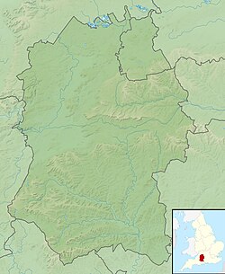
Cunetio was a large walled town in a valley of the River Kennet in modern-day Wiltshire, England. The settlement was occupied from the 2nd century AD by Romano-British people until the post-Roman period, and was abandoned in the early 5th century. Its site is near the village of Mildenhall, about 1+1⁄2 miles (2.4km) east of the market town of Marlborough.
The entire town lay undiscovered until it was identified from aerial photos in the 1940s. Archaeological excavations have revealed that the town was a substantial urban area defended by large masonry walls. Artefacts recovered from the site include kitchenware, personal effects, and two hoards of Roman coinage.
The Cunetio site has been known since the 19th century, when local antiquarians conducted sporadic excavations. The full scale and importance of the site, however, was identified from aerial photos of crop marks taken in 1940, and the site has been sporadically excavated since the 1950s alongside the continuation of aerial photography to further map the site.[1] In the 1960s, a small coin hoard was found, followed in 1978 by the much larger Cunetio Hoard of over 55,000 coins. The site was dug and geophysically surveyed in 2009 by Channel 4's archaeological television programme Time Team, which found many more coins and other objects.[2]
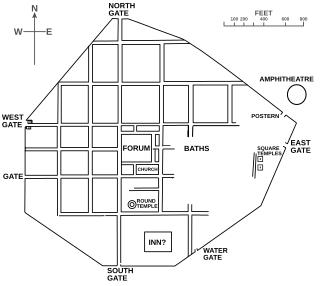
The town grew around a mansio that had been built near the crossing of two Roman roads: the east–west road (Margary 53) from Speen in Berkshire to Aquae Sulis (Bath), and the south-east to north road (43) from Winchester to Wanborough.[3][4] As the town grew, it developed a regular grid of streets and stone buildings on its eastern side but retained less regular and substantial structures in the west part. The settlement's original defences were earthworks and an outer ditch; in the 4th century AD, these were replaced by massive stone walls 4m (13ft) wide, a large western gateway, and 17 semi-octagonal, external wall-towers.
The masonry walls ran inside and parallel with the original defences on the east side but outside of them on the south and west sides. The stone towers were approximately every 36.7m (120ft) apart. Excavations of the west gate show it was flanked by two towers and possibly had a set of iron-gates similar to a portcullis, because grooves were found in the remains of the towers' footings.
Archaeological examinations of the site do not show why Cunetio deserved so much expenditure on improving its defences, an act that was a rare occurrence for inland Britannia at the time, when most Roman military engineering projects were focused on the Saxon Shore forts. Two theories have been suggested: first that the town was being converted into a Legionary fortress to re-establish Roman authority in this part of the province of Britannia. Second, that the improvement work was being orchestrated by an ambitious local British governor – the type of man who would, within a generation or so, be setting himself up as a war-lord or regional chieftain. Interpretation therefore swings between the Roman Empire re-establishing its authority after various rebellions and uprisings, or Roman authority breaking down.[5]
In the 3rd century, the town was a prosperous settlement,[6] and by the start of the 4th, it had become a centre of villas.[7] It has also been suggested that the town was reorganised as a centre of taxation, administration, and military functions later in the 4th century AD, coinciding with the addition of the defensive stone wall.[8] However, the Roman withdrawal from Britain c. 410 caused Cunetio to rapidly decline in importance, until it was completely abandoned.[9][10]
Notes
↑ Corney, M. 1997. The Origins and Development of the 'Small Town' of Cunetio, Mildenhall, Wiltshire. Britannia. 28. 337-350.
↑ Hostetter, Eric; Howe, Thomas Noble; Allison, E. P. (1997). The Romano-British Villa at Castle Copse, Great Bedwyn. Indiana University Press. p.45. ISBN978-0-253-32802-1.
↑ Bland, Roger; Besly, Edward; Burnett, Andrew (2019). The Cunetio and Normanby Hoards: Roger Bland, Edward Besly and Andrew Burnett, with notes to aid identification by Sam Moorhead. Spink Books. p.173. ISBN978-1-912667-33-8.
↑ Pohl, Walter; Gantner, Clemens; Grifoni, Cinzia; Pollheimer-Mohaupt, Marianne (2018). Transformations of Romanness: Early Medieval Regions and Identities. Walter de Gruyter GmbH & Co KG. ISBN978-3-11-059756-1.
↑ Davison, Steve (1 June 2015). Walking in the North Wessex Downs. Cicerone Press Limited. ISBN978-1-78362-212-2.
Calleva Atrebatum was an Iron Age oppidum, the capital of the Atrebates tribe. It then became a walled town in the Roman province of Britannia, at a major crossroads of the roads of southern Britain.
Camulodunum, the Ancient Roman name for what is now Colchester in Essex, was an important castrum and city in Roman Britain, and the first capital of the province. A temporary "strapline" in the 1960s identifying it as the "oldest recorded town in Britain" has become popular with residents and is still used on heritage roadsigns on trunk road approaches. Originally the site of the Brythonic-Celtic oppidum of Camulodunon, capital of the Trinovantes and later the Catuvellauni tribes, it was first mentioned by name on coinage minted by the chieftain Tasciovanus some time between 20 and 10 BC. The Roman town began life as a Roman legionary base constructed in the AD 40s on the site of the Brythonic-Celtic fortress following its conquest by the Emperor Claudius. After the early town was destroyed during the Iceni rebellion in AD 60/61, it was rebuilt, reaching its zenith in the 2nd and 3rd centuries. During this time it was known by its official name Colonia Claudia Victricensis, often shortened to Colonia Victricensis, and as Camulodunum, a Latinised version of its original Brythonic name. The town was home to a large classical temple, two theatres, several Romano-British temples, Britain's only known chariot circus, Britain's first town walls, several large cemeteries and over 50 known mosaics and tessellated pavements. It may have reached a population of 30,000 at its height.
Mildenhall is a village and civil parish in the Kennet Valley in Wiltshire, England, immediately east of the market town of Marlborough. The village is about 1.5 miles (2 km) east of the centre of Marlborough, on the minor road which follows the River Kennet towards Ramsbury. The parish also contains the hamlets of Poulton and Stitchcombe. The name has often been written as Minal, and this is continued in the present-day pronunciation.
Isca Dumnoniorum, also known simply as Isca, was originally a Roman legionary fortress for the Second Augustan Legion in the Roman province of Britannia at the site of present-day Exeter in Devon.
Alchester is the site of an ancient Roman town. The site is not included in any ancient references; hence, the Roman name is not known. However, Eilert Ekwall contended that it appears as Alavna in the Ravenna Cosmography, with the addition of the Old English ceaster to signify a Roman fort. It lies about 2 miles (3 km) south of Bicester, in the northwest corner of the civil parish of Wendlebury in the English county of Oxfordshire.
The Hoxne Hoard is the largest hoard of late Roman silver and gold discovered in Britain, and the largest collection of gold and silver coins of the fourth and fifth centuries found anywhere within the former Roman Empire. It was found by Eric Lawes, a metal detectorist in the village of Hoxne in Suffolk, England in 1992. The hoard consists of 14,865 Roman gold, silver, and bronze coins and approximately 200 items of silver tableware and gold jewellery. The objects are now in the British Museum in London, where the most important pieces and a selection of the rest are on permanent display. In 1993, the Treasure Valuation Committee valued the hoard at £1.75 million.
Aquae Arnemetiae was a small town in the Roman province of Britannia. The settlement was based around its natural warm springs. The Roman occupation ran from around 75 AD to 410 AD. Today it is the town of Buxton, Derbyshire in England.
Venta Silurum was a town in Roman Britain (Britannia). Today it consists of remains in the village of Caerwent in Monmouthshire, south east Wales.
Durocornovium was a Roman town in Britain, situated on the Roman road between Corinium Dobunnorum (Cirencester) and Calleva Atrebatum (Silchester). In many ways Durocornovium was a typical small Roman town.
Rockbourne Roman Villa is a Roman courtyard villa excavated and put on public display in the village of Rockbourne in the English county of Hampshire. The villa was discovered in 1942 by a local farmer and excavated by A. T. Morley Hewitt over the next thirty years.
Littlecote Roman Villa is an extensive and exceptional Roman villa, with associated religious complex, at Littlecote Park just over a mile west of Hungerford, Berkshire. It has been excavated and is on display to the public in the grounds of the estate.
Port Way is an ancient road in southern England, which ran from Calleva Atrebatum in a south-westerly direction to Sorbiodunum. Often associated with the Roman Empire, the road may have predated the Roman occupation of Britain.
Isurium or Isurium of the Brigantes was a Roman fort and town in the province of Britannia at the site of present-day Aldborough in North Yorkshire, England, in the United Kingdom. Its remains—the Aldborough Roman Site—are in the care of English Heritage.
Deva Victrix, or simply Deva, was a legionary fortress and town in the Roman province of Britannia on the site of the modern city of Chester. The fortress was built by the Legio II Adiutrix in the 70s AD as the Roman army advanced north against the Brigantes, and rebuilt completely over the next few decades by the Legio XX Valeria Victrix. In the early 3rd century the fortress was again rebuilt. The legion probably remained at the fortress until the late 4th or early 5th century, upon which it fell into disuse.
Coria was a fort and town 2.5 miles (4.0 km) south of Hadrian's Wall, in the Roman province of Britannia. It was strategically located on the junction of a major Roman north–south road with the River Tyne and the Roman Stanegate road, which was also the first frontier line which ran east–west between Coria and Luguvalium. Corbridge Roman Site is in the village of Corbridge in the county of Northumberland.
Mediolanum was a fort and small town in the Roman province of Britannia. Today it is known as Whitchurch, located in the English county of Shropshire.
The Cunetio Hoard, also known as the Mildenhall Hoard, is the largest hoard of Roman coins found in Britain. It was discovered in 1978 at the site of the Roman town of Cunetio, near modern-day Mildenhall, Wiltshire, and consisted of 54,951 low value coins. The coins were contained in a large pot and a lead container. The coins are now in the British Museum and the pot is on display at the Wiltshire Museum in Devizes.
Archaeology is promoted in Jersey by the Société Jersiaise and by Jersey Heritage. Promotion in the Bailiwick of Guernsey being undertaken by La Société Guernesiaise, Guernsey Museums, the Alderney Society with World War II work also undertaken by Festung Guernsey.
This page is based on this Wikipedia article Text is available under the CC BY-SA 4.0 license; additional terms may apply. Images, videos and audio are available under their respective licenses.