Durnovaria is a suggested spelling for the Latin form of the name of the Roman town of Dorchester in the modern English county of Dorset, amended from the actually observed Durnonovaria. Upon the assumption that the name was originally Brythonic, it is suggested that the first element in the name, *durno- may mean "fist" like (Welshdwrn[1] ‘fist, knob’) and the second may be related to Old Irishfáir ~ fóir denoting a confined area[2] or den. A simpler amendment (one letter instead of two) would lead to *Duronovaria, making this place one of up to 18 ancient British names that contain Duro- and mostly occur at river crossings, while -novaria has two possible ancient parallels in Britain associated with river junctions. That analysis would perfectly fit the geographical situation of Dorchester.[citation needed]
The site of present-day Dorchester may have originally been a small garrison fort for the Legio II Augusta established shortly after the Roman conquest on the site of Greyhound Yard. When the military moved away, around AD 65–70, Durnovaria became a civilian settlement, apparently[3] the civitas Durotrigum of the tribal confederacy of the Durotriges. Shafts were dug to deposit ritual foundation items.[4] An organised street plan was laid out, ignoring earlier boundaries, the streets lined with timber-slot structures; public buildings including thermae were erected and an artificial water supply established.[5] The town seems to have become one of twin capitals for the local Durotriges tribe.
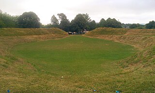
It was an important local market centre, particularly for Purbeck marble, shale and the pottery industries from Poole Harbour and the New Forest. The town remained small, around the central and southern areas of the present settlement, until expansion to the north-west, around Colliton Park, in the 2nd century. By the middle of this century, the town defences were added and Maumbury Rings, a neolithichenge monument, was converted for use as an amphitheatre.
The third century saw the first replacement of timber buildings with stone ones, an unexpectedly late development in an area with several good sources of building stone.[6] There were many fine homes for rich families and their excavated mosaic floors suggest a mosaic school of art had a workshop in the town, members of which seem to have travelled in the area to execute mosaic floors in villas away from Durnovaria itself.[7] A large late-Roman and Christian cemetery has been excavated at Poundbury just to the west of the town, but little is known of Durnovaria's decline after the departure of the Roman administration. The name, however, survived to become the Anglo-SaxonDornwaraceaster and modern 'Dorchester'. The residents of modern day Dorchester are known as Durnovarians.[8]
Extant remains
The town still has some Roman features, including part of the town walls and the foundations of a Roman town house, which are freely accessible near County Hall. There are many Roman finds in the County Museum. The Romans built an aqueduct to supply the town with water, traces remain at nearby Whitfield Farm and approaching Poundbury tunnel on the Dorchester - Yeovil railway. Near the town centre is Maumbury Rings, an ancient British earthwork converted by the Romans for use as an amphitheatre, and to the north west is Poundbury Hill, another pre-Roman fortification.
Part of a Roman road, known today as High West Street, exists underneath the Dorset Museum, and a portion of it is displayed within the museum. The road ran through the centre of Durnovaria.
There is little evidence to show whether or not Durnovaria survived into the post-Roman era: Gildas' record of a tradition, given in De Excidio et Conquestu Britanniae iii, of twenty-eight cities and sundry castles of former happy times was not provided with any names. Surviving northern boundaries of the administrative region, or civitas that included Dorset, reached as far as Selwood, and mark the county division between Somerset and Wiltshire to this day.[9] In the sub-Roman period, as urban centres were progressively abandoned, the centres of administration and justice, such as they were, generally removed to fortified strongholds. The city's site is attested as Dornwaraceaster in the ninth century, elided to produce 'Dornaceaster, first recorded in 937.[10]
↑ "The fact is nowhere attested", C. E. Stevens noted in 1937, adding that Ptolemy, perhaps using a lost pre-occupation source, gives Durium (Geography ii.3.13) as the one town of the Durotriges,; see Stevens, "Gildas and the Civitates of Britain" The English Historical Review52 No. 206 (April 1937:193-203) pp 202-03, note 3.
↑ Sampled shafts in Greyhound Yard, Dorchester, in advance of rebuilding, published by Woodward et al., 1993, were reidentified as on-going ritual deposits, notably of sacrificed puppies and black carrion birds— crows, ravens and jackdaws— summarised by Peter Woodward and Ann Woodward, "Dedicating the Town: Urban Foundation Deposits in Roman Britain" World Archaeology36.1 (March 2004:68-86) and compared with other Romano-British sites.
↑ Details are in R.J.C. Smith, Excavations at County Hall, Dorchester, Dorset, 1988, in the North-West Quarter of Durnovaria, (Wessex Archaeology Report 4) Salisbury 1993.
↑ Remarked upon by J. H. Williams, "Roman Building-Materials in South-East England" Britannia2 (1971:166-195) p. 170; he noted the quarries of Purbeck Limestone, Lias limestone and Hamstone from Ham Hill.
↑ D. J. Smith, "The mosaic pavements", in A.L.F. Rivet, ed., The Roman Villa in Britain (1969:71-125).
↑ Bruce Eagles, "Britons and Saxons on the Eastern Boundary of the Civitas Durotrigum" Britannia35 (2004:234-240) passim traces clues of identifiable former tribal arrangements reflected in the eastern Roman and post-Roman boundary.
↑ Anton Fägersten, Place-Names in Dorset (Uppsala) 1933:1-2, noted by F. M. Stenton, "Presidential Address: The Historical Bearing of Place-Name Studies; England in the Sixth Century" Transactions of the Royal Historical Society 4th Ser., 21 (1939:1-19) p. 6 note 1.
Further reading
Breeze, A., "Durnovaria, the Roman name of Dorchester", Notes & Queries for Somerset & Dorset35.4 pp 69–72.
Trevarthen, M. (2008), Suburban life in Roman Durnovaria: Excavations at the former County Hospital Site, Dorchester, Dorset 2000–2001, Trust for Wessex Archaeology, ISBN978-1874350460
Dorset is a ceremonial county in South West England. It is bordered by Somerset to the north-west, Wiltshire to the north and the north-east, Hampshire to the east, the Isle of Wight across the Solent to the south-east, the English Channel to the south, and Devon to the west. The largest settlement is Bournemouth, and the county town is Dorchester.
The River Frome is a river in Dorset in the south of England. At 30 miles (48 km) long it is the major chalkstream in southwest England. It is navigable upstream from Poole Harbour as far as the town of Wareham.
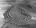
Maiden Castle is an Iron Age hillfort 1.6 mi (2.6 km) southwest of Dorchester, in the English county of Dorset. Hill forts were fortified hill-top settlements constructed across Britain during the Iron Age.
Dorchester is the county town of Dorset, England. It is situated between Poole and Bridport on the A35 trunk route. A historic market town, Dorchester is on the banks of the River Frome to the south of the Dorset Downs and north of the South Dorset Ridgeway that separates the area from Weymouth, 7 miles (11 km) to the south. The civil parish includes the experimental community of Poundbury and the suburb of Fordington.
The Isle of Purbeck is a peninsula in Dorset, England. It is bordered by water on three sides: the English Channel to the south and east, where steep cliffs fall to the sea; and by the marshy lands of the River Frome and Poole Harbour to the north. Its western boundary is less well defined, with some medieval sources placing it at Flower's Barrow above Worbarrow Bay. John Hutchins, author of The History and Antiquities of the County of Dorset, defined Purbeck's western boundary as the Luckford Lake stream, which runs south from the Frome. According to writer and broadcaster Ralph Wightman, Purbeck "is only an island if you accept the barren heaths between Arish Mell and Wareham as cutting off this corner of Dorset as effectively as the sea." The most southerly point is St Alban's Head.
West Dorset was a local government district in Dorset, England. The district was formed on 1 April 1974 under the Local Government Act 1972, and was a merger of the boroughs of Bridport, Dorchester and Lyme Regis, along with Sherborne urban district and the rural districts of Beaminster, Bridport, Dorchester and Sherborne. Its council was based in Dorchester.
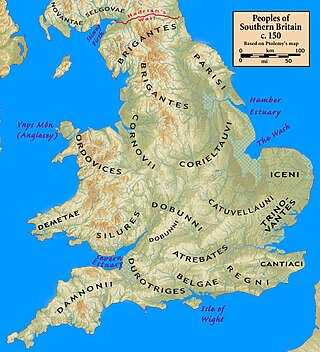
The Durotriges were one of the Celtic tribes living in Britain prior to the Roman invasion. The tribe lived in modern Dorset, south Wiltshire, south Somerset and Devon east of the River Axe and the discovery of an Iron Age hoard in 2009 at Shalfleet, Isle of Wight gives evidence that they may also have lived in the western half of the island. After the Roman conquest, their main civitates, or settlement-centred administrative units, were Durnovaria and Lindinis. Their territory was bordered to the west by the Dumnonii; and to the east by the Belgae.
Maumbury Rings is a Neolithic henge in the south of Dorchester town in Dorset, England. It is a large circular earthwork, 85 metres in diameter, with a single bank and an entrance to the north east. It was modified during the Roman period when it was adapted for use as an amphitheatre, and the site was remodelled again during the English Civil War when it was used as an artillery fort guarding the southern approach to Dorchester. The monument is now a public open space, and used for open-air concerts, festivals and re-enactments.
Badbury Rings is an Iron Age hill fort and Scheduled Monument in east Dorset, England. It was in the territory of the Durotriges. In the Roman era a temple was located immediately west of the fort, and there was a Romano-British town known as Vindocladia a short distance to the south-west.
Dorset is a rural county in south west England. Its archaeology documents much of the history of southern England.
Poundbury Hill is the site of a scheduled Prehistoric and Roman archaeological remains and includes evidence of a Neolithic settlement, a substantial Bronze Age occupation site and an Iron Age hillfort. There are also late Iron Age burials and a section of Roman aqueduct. On the eastern side is an earlier Romano-British farmstead; and an extensive later cemetery, belonging to the Roman town Durnovaria.
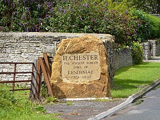
Lindinis or Lendiniae was a small town in the Roman province of Britannia. Today it is known as Ilchester, located in the English county of Somerset in the United Kingdom.
The Roman Town House in Dorchester is a Roman ruin within Colliton Park, Dorchester, Dorset, England. Dorset County Council acquired Colliton Park in 1933 as the site for the construction of County Hall. The Town House was discovered in 1937/38 during an archaeological investigation carried out by the Dorset Natural History and Archaeological Society prior to the construction of the new building. Plans for County Hall were modified so that the Town House could be retained on site.
Bucknowle Farm is the site of a Romano-British settlement and a Roman villa, located 1 km (0.62 mi) southeast of Church Knowle and 1 km (0.62 mi) southwest of Corfe Castle village in Dorset, England. It is about 7 km (4.3 mi) south of Wareham and approximately 9 km (5.6 mi) west of Swanage in the heart of the Isle of Purbeck.
Dorset is a county located in the middle of the south coast of England. It lies between the latitudes 50.512°N and 51.081°N and the longitudes 1.682°W and 2.958°W, and occupies an area of 2,653 km2. It spans 90 kilometres (56 mi) from east to west and 63 kilometres (39 mi) from north to south.
Duropolis is the name of an archaeological site at Winterborne Kingston in the English county of Dorset, believed to be the remains of the first planned town in Britain. The site's first discoveries were made in 2008 led by co-directors Miles Russell and Paul Cheetham. The 32,000 square metres (340,000 sq ft) Iron Age settlement is believed to date to around 100 BCE, making it 70 years older than the Roman town of Silchester.
The Town Walks are a series of public walks in Dorchester, Dorset, England, along the former Roman defences of the town.
Bucknowle Roman villa is a Roman villa in Dorset, England. It is located within a camping site within the grounds of Bucknowle Farm.
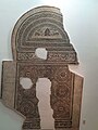
The Fordington mosaic, also known as the Fordington High Street mosaic, is a Roman floor mosaic from the 2nd century AD, found in Fordington, Dorchester in England, in what was once Durnovaria; it is now on display at the Dorset Museum. It depicts Oceanus, marine life, and the ocean.
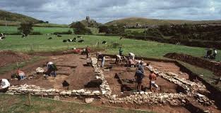
Greyhound Yard, also known as the Dorchester henge, is an archaeological site located within the Tudor Arcade shopping centre and the associated Charles Street within Dorchester, United Kingdom. It was once the site of a Neolithic henge and later a range of other buildings including a Roman villa on the outskirts of Durnovaria.
This page is based on this Wikipedia article Text is available under the CC BY-SA 4.0 license; additional terms may apply. Images, videos and audio are available under their respective licenses.