The Humber is a large tidal estuary on the east coast of Northern England. It is formed at Trent Falls, Faxfleet, by the confluence of the tidal rivers Ouse and Trent. From there to the North Sea, it forms part of the boundary between the East Riding of Yorkshire on the north bank and North Lincolnshire on the south bank. Also known as the River Humber, it is tidal its entire length.

Deira was an area of Post-Roman Britain, and a later Anglian kingdom.
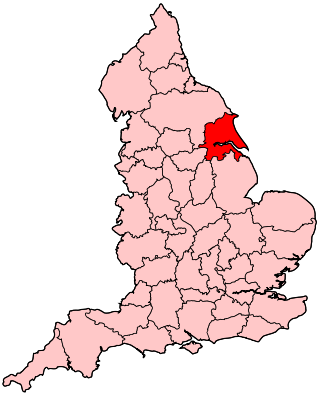
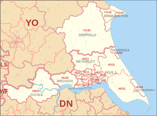
The East Riding of Yorkshire, often abbreviated to the East Riding or East Yorkshire, is a ceremonial county in the Yorkshire and the Humber region of England. It borders North Yorkshire to the north and west, South Yorkshire to the south-west, and Lincolnshire to the south across the Humber Estuary. The city of Kingston upon Hull is the largest settlement.

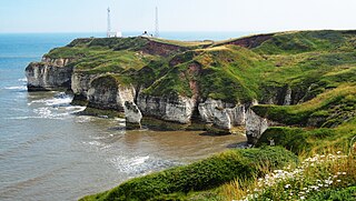
The Yorkshire Wolds are hills in the counties of the East Riding of Yorkshire and North Yorkshire in Northern England. They are the northernmost chalk hills in the UK and within lies the northernmost chalk stream in Europe, the Gypsey Race.

Whitton is a village and civil parish in North Lincolnshire, England. The 2011 census found 212 inhabitants, in 92 households. It is situated at the northern termination of the Lincoln Cliff range of hills, on the south shore of the Humber about 3 miles (4.8 km) below Trent Falls, and 9 miles (14 km) west of Barton-upon-Humber. The parish is bounded on the west by Alkborough, on the east by Winteringham and, to the south, by West Halton.
Humberside was a non-metropolitan and ceremonial county in Northern England from 1 April 1974 until 1 April 1996. It was composed of land from either side of the Humber, created from portions of the East Riding of Yorkshire, West Riding of Yorkshire, and the northern part of Lindsey, Lincolnshire. The county council's headquarters was County Hall at Beverley, inherited from East Riding County Council. Its largest settlement and only city was Kingston upon Hull. Other notable towns included Goole, Beverley, Scunthorpe, Grimsby, Cleethorpes and Bridlington. The county stretched from Wold Newton at its northern tip to a different Wold Newton at its southernmost point.
Yorkshire is a historic county of England, centred on the county town of York. The region was first occupied after the retreat of the ice age around 8000 BC. During the first millennium AD it was inhabited by celtic Britons and occupied by Romans, Angles and Vikings. The name comes from "Eborakon" an old Brythonic name which probably derives from "Efor" or "the place of the yew-trees." Many Yorkshire dialect words and aspects of pronunciation derive from old Norse due to the Viking influence in this region. The name "Yorkshire", first appeared in writing in the Anglo-Saxon Chronicle in 1065. It was originally composed of three sections called Thrydings, subsequently referred to as Ridings.

North Ferriby is a village and civil parish in the Haltemprice area of the East Riding of Yorkshire, England.

Brough is a town in the East Riding of Yorkshire, England. It is part of the civil parish of Elloughton-cum-Brough with the neighbouring village of Elloughton. Brough is situated on the northern bank of the Humber Estuary, approximately 12 miles (19 km) west of Hull city centre. Brough has a long association with BAE Systems. It was recently recognised as one of the most desirable places to live in Yorkshire, with a rising affluent population and a growing reputation for prestige, quality of life, and thriving communities such as Elloughton-Cum-Brough In Bloom.
North Humberside is a former postal county of England. It was introduced by the Royal Mail on 1 July 1974, when some addresses were altered in response to the changes in administration brought about under the Local Government Act 1972.

Brantingham is a village and civil parish in the East Riding of Yorkshire, England, about 2 miles (3 km) north of Brough, 12 miles (19 km) west of Hull and north of the A63 road. The 2011 UK Census gave the parish had a population of 370, marking a decrease from the 2001 UK census figure of 410. The 2019 estimate was 319.
The town of Pocklington in the East Riding of Yorkshire, England has a recorded written history that goes back around 1,500 years, and archaeological evidence shows settlement at the site as long as 2,500 years ago. This gives it a longer history of settlement than larger contemporary settlements in the region and country such as York and even London. During this time, it has experienced plague, several invasions, the loss of its railway, and its marginalisation to a backwater under the Romans. Nevertheless, Pocklington has prospered where other market towns have failed. It has always been the commercial and civic centre for the district and was at one point the second largest settlement in Yorkshire. It is the focal point of an area which has seen significant events through the centuries, many influencing English history.

Welton is a village and civil parish in the East Riding of Yorkshire, England. The parish extends to the bank of the Humber Estuary at its southern extreme, and into the Yorkshire Wolds in the northern part. The A63 road and Hull to Selby railway line both bisect the parish east–west, south of Melton and Welton.

The Parisi were a British Celtic tribe located somewhere within the present-day East Riding of Yorkshire, in England, known from a single brief reference by Ptolemy in his Geographica of about AD 150. Many writers have connected them with the archaeological Arras culture and some with the more widely known Parisii of Gaul.
The East Riding of Yorkshire is a local government district with unitary authority status, and is a ceremonial county of England. It is named after the historic East Riding of Yorkshire which was one of three ridings alongside the North Riding and West Riding, which were constituent parts a Yorkshire ceremonial and administrative county until 1974. From 1974 to 1996 the area of the modern East Riding of Yorkshire constituted the northern part of Humberside.

Thomas Sheppard was a British museum curator and amateur geologist, who founded several museums in Kingston upon Hull and in the East Riding of Yorkshire, England.

Anna Mary Hawthorn Kitson Clark,, married name Mary Chitty, was an English archaeologist, curator, and independent scholar. She specialised in the archaeology of Romano-British Northern England but was also involved in excavations outside the United Kingdom and the Roman period. Her 1935 work, A Gazetteer of Roman Remains in East Yorkshire, "remains one of the starting points for any study of the Romans in the north of England".

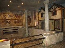
The Hull and East Riding Museum of Archaeology is located in the Museums Quarter of the Old Town in Kingston upon Hull, England. It dates back to 1925 as the Museum of Commerce and Industry in a former Customs House but acquired its present name in 1989 with a major refurbishment and new entrance, with the transport section moving to a separate museum. It displays items from prehistoric to medieval in the area, many of them in life-size tableaux or reconstructions of rooms and buildings.

Portus Felix was a small coastal town in the Roman province of Britannia, in the area that became the East Riding of Yorkshire. Filey is considered to be the probable location of the port settlement. Sewerby and Bridlington have also been suggested.
Brantingham Roman villa is a Roman villa, now a scheduled monument, near Brantingham, East Riding of Yorkshire, England.