Durovernum Cantiacorum

Last updated

Plan of Durovernum, from The Saxon Cathedral at Canterbury and The Saxon Saints Buried Therein Plan of Durovernum.png
Plan of Durovernum, from The Saxon Cathedral at Canterbury and The Saxon Saints Buried Therein

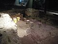
Durovernum Cantiacorum was a town and hillfort (Latin : oppidum ) in Roman Britain at the site of present-day Canterbury in Kent. It occupied a strategic location on Watling Street at the best local crossing of the Stour, which prompted a convergence of roads connected to the ports of Dubris (Dover), Rutupiae (Richborough), Regulbium (Reculver) and Portus Lemanis (Lympne). Considerable archaeological evidence of Roman activity has been found in Canterbury, much of which can now be found in the Roman Museum built on the remains of a Roman townhouse.

Contents

Origins

The name Durovernum Cantiacorum is Latin for "Durovernum of the Cantiaci", preserving the name of an earlier British town whose ancient British name has been reconstructed as *Durou̯ernon ("Stronghold by the Alder Grove"), [1] although the name is sometimes supposed to have derived from various British names for the Stour. [2] The Iron-Age oppidum at the site was triple-ditched. The site seems to have been occupied and fortified by the Romans shortly after their invasion in AD 43. Military occupation continued until at least the time of Boudica's rebellion.

Development

Watling Street linked Britain to the rest of the Roman Empire. Watling Street route.jpg
Watling Street linked Britain to the rest of the Roman Empire.

There is no evidence of much development in Durovernum until the Flavian period (69-96), after demilitarisation. [3] It became the civitas capital of the Cantiaci (Cantii) tribes.

A large religious and administrative complex was soon established at its centre, consisting of forum and basilica, temple enclosure and theatre. The theatre, originally built around AD 80, was totally rebuilt in the early 3rd century. It was probably associated with religious festivals as much as the dramatic arts. The public baths were just to the north-east. A number of other possible temple and/or church sites have also been identified. The town was enclosed by defensive walls in the late 3rd century and was given single-arched gateways. Private buildings within the walls were originally of timber, but were later replaced with stone and some furnished with mosaic floors. An extensive complex of wooden pipes serviced the town. Industries included brick, tile and pottery production, as well as bronze working. There were many commercial shops, notably a baker's shop with donkey-driven millstone. Cemeteries outside the town appear to have continued in Christian use and St Martin's Church appears to be built around an old Roman mausoleum which stood in one of these.

Decline

Because of its links with Gaul, Durovernum seems to have survived in good order until the Roman administration left around AD 410. However, after that, its decline was rapid. Mercenaries were hired to defend the town but they revolted. By the time of the Battle of Aylesford in the mid-5th century, the Jutes had taken over the area. The British and Latin name survived as the medieval Latin placename Dorobernia or Dorovernia, [2] but the town also became known in Old Welsh as Cair Ceint ("Fortress of Kent") [4] [5] and in Old English as Cantwareburh ("Kentish Stronghold"), [6] which developed into the modern "Canterbury".

Archaeology

The Canterbury Roman Museum houses Roman artifacts from across the town, as well as an in situ Roman town house and its mosaics.

Rediscovery of Roman Canterbury

Sheppard Frere undertook excavations in Canterbury from 1949 to 1955 and 1980–1984. [7]

Related Research Articles

Roman Britain Britain under Roman rule (43 AD - c.410 AD)

Roman Britain refers to the period in classical antiquity when large parts of the island of Great Britain were under occupation by the Roman Empire. The occupation lasted from AD 43 to AD 410. During that time, the territory conquered was raised to the status of a Roman province.

AD 43 chars (XLIII) was a common year starting on Tuesday of the Julian calendar. At the time, it was known as the Year of the Consulship of Caesar and Vitellius. The denomination AD 43 for this year has been used since the early medieval period, when the Anno Domini calendar era became the prevalent method in Europe for naming years.

Lullingstone Roman Villa Roman villa in Britain

Lullingstone Roman Villa is a villa built during the Roman occupation of Britain, situated in Lullingstone near the village of Eynsford in Kent, south eastern England. The villa is located in the Darent Valley, along with six others, including those at Crofton, Crayford and Dartford. Constructed in the 1st century, perhaps around 80-90 CE, the house was repeatedly expanded and occupied until it was destroyed by fire in the 4th or 5th century. The villa was occupied over various periods within the Romano-British period, but after its destruction, it is only thought to have been reoccupied during the Medieval Times. The occupants were most likely wealthy Romans or native Britons who had adopted Roman customs.

Fishbourne Roman Palace Roman palace near Chichester in West Sussex, England

Fishbourne Roman Palace is located in the village of Fishbourne, Chichester in West Sussex. The palace is the largest Roman residence north of the Alps. and has an unusually early date of 75 AD, around thirty years after the Roman conquest of Britain.

Canterbury Cathedral city in Kent, England

Canterbury is a cathedral city and UNESCO World Heritage Site, situated in the heart of the City of Canterbury, a local government district of Kent, England. It lies on the River Stour.

Camulodunum Roman castrum where Colchester, England now stands

Camulodunum, the Ancient Roman name for what is now Colchester in Essex, was an important city in Roman Britain, and the first capital of the province. A temporary "strapline" in the 1960s identifying it as the oldest recorded town in Britain has become popular with residents and is still used on heritage roadsigns on trunk road approaches Originally the site of the Brythonic-Celtic oppidum of Camulodunon, capital of the Trinovantes and later the Catuvellauni tribes, it was first mentioned by name on coinage minted by the chieftain Tasciovanus some time between 20 and 10 BC. The Roman town began life as a Roman legionary base constructed in the AD 40s on the site of the Brythonic-Celtic fortress following its conquest by the Emperor Claudius. After the early town was destroyed during the Iceni rebellion in AD 60/61, it was rebuilt, reaching its zenith in the 2nd and 3rd centuries. During this time it was known by its official name Colonia Claudia Victricensis, often shortened to Colonia Victricensis, and as Camulodunum, a Latinised version of its original Brythonic name. The town was home to a large classical temple, two theatres, several Romano-British temples, Britain's only known chariot circus, Britain's first town walls, several large cemeteries and over 50 known mosaics and tessellated pavements. It may have reached a population of 30,000 at its height. It was not until the late 18th century that historians realised that Colchester's physical Brythonic and Roman remains were the city mentioned in ancient literature as "Camulodunum".

Londinium Settlement established on the current site of the City of London around AD 47–50

Londinium, also known as Roman London, was the capital of Roman Britain during most of the period of Roman rule. It was originally a settlement established on the current site of the City of London around AD 47–50. It sat at a key crossing point over the River Thames which turned the city into a road nexus and major port, serving as a major commercial centre in Roman Britain until its abandonment during the 5th century.

Cantiaci

The Cantiaci or Cantii were an Iron Age Celtic people living in Britain before the Roman conquest, and gave their name to a civitas of Roman Britain. They lived in the area now called Kent, in south-eastern England. Their capital was Durovernum Cantiacorum, now Canterbury.

Catuvellauni Celtic tribe

The Catuvellauni were a Celtic tribe or state of southeastern Britain before the Roman conquest, attested by inscriptions into the 4th century.

Viroconium Cornoviorum

Viroconium or Uriconium, formally Viroconium Cornoviorum, was a Roman city, one corner of which is now occupied by Wroxeter, a small village in Shropshire, England, about 5 miles (8.0 km) east-south-east of Shrewsbury. At its peak, Viroconium is estimated to have been the 4th-largest Roman settlement in Britain, a civitas with a population of more than 15,000. The settlement probably lasted until the end of the 7th century or the beginning of the 8th. Extensive remains can still be seen.

Durnovaria

Durnovaria is a suggested spelling for the Latin form of the name of the Roman town of Dorchester in the modern English county of Dorset, amended from the actually observed Durnonovaria. Upon the assumption that the name was originally Brythonic, it is suggested that the first element in the name, *durno- may mean "fist" like and the second may be related to Old Irish fáir ~ fóir denoting a confined area or den. A simpler amendment would lead to *Duronovaria, making this place one of up to 18 ancient British names that contain Duro- and mostly occur at river crossings, while -novaria has two possible ancient parallels in Britain associated with river junctions. That analysis would perfectly fit the geographical situation of Dorchester.

Sheppard Frere

Sheppard Sunderland Frere, CBE, FSA, FBA was a British historian and archaeologist who studied the Roman Empire. He was a fellow at All Souls College, Oxford.

Michael Gordon Fulford, is a British archaeologist and academic, specialising in the British Iron Age, Roman Britain and landscape archaeology. He has been Professor of Archaeology at the University of Reading since 1993.

Venta Silurum

Venta Silurum was a town in the Roman province of Britannia or Britain. Today it consists of remains in the village of Caerwent in Monmouthshire, south east Wales. Much of it has been archaeologically excavated and is on display to the public.

Bignor Roman Villa

Bignor Roman Villa is a large Roman courtyard villa which has been excavated and put on public display on the Bignor estate in the English county of West Sussex. It is well known for its high quality mosaic floors, which are some of the most complete and intricate in the country.

Isurium Brigantum Roman fort and town at Aldborough in North Yorkshire, England

Isurium or Isurium of the Brigantes was a Roman fort and town in the province of Britannia at the site of present-day Aldborough in North Yorkshire, England, in the United Kingdom. Its remains—the Aldborough Roman Site—are in the care of English Heritage.

Ratae Corieltauvorum

Ratae Corieltauvorum or simply Ratae was a town in the Roman province of Britannia. Today it is known as Leicester, located in the English county of Leicestershire.

Regulbium Roman fort in Kent, England

Regulbium was the name of an ancient Roman fort of the Saxon Shore in the vicinity of the modern English resort of Reculver in Kent. Its name derives from the local Brythonic language, meaning "great headland" (*Rogulbion).

Canterbury Roman Museum

The Canterbury Roman Museum in Canterbury, Kent, houses a Roman pavement which is a scheduled monument, in the remains of a Roman courtyard house which itself is a grade I listed building. The pavement was discovered after World War II bombing, and has been open to the public since 1946. The museum was established in 1961. It houses many excavated artifacts from Roman Canterbury, including the important late Roman silver hoard known as the Canterbury Treasure, together with reconstructions of the Roman town.

Britannia is an annual peer-reviewed academic journal published by Cambridge University Press on behalf of the Society for the Promotion of Roman Studies. It was established in 1970 and the first editor-in-chief was Sheppard Frere. The journal covers research on the province of Roman Britain, Iron Age and post-Roman Britain, and western provincial archaeology, as well as excavation reports. It was established because of the large increase in archaeological excavations, increased publication costs, and in order to establish coherence to the field of Roman Britain.

References

  1. Lyle p. 29.
  2. 1 2 Hasted, Edward (1800). The History and Topographical Survey of the County of Kent. Vol. XI. Canterbury: W. Bristow. pp. 135–139. Retrieved 13 February 2015.
  3. Todd, Malcolm (2004). A companion to Roman Britain. Volume 9 of Blackwell companions to British history. Wiley-Blackwell. p. 174. ISBN   978-0-631-21823-4.
  4. Nennius (attrib.). Theodor Mommsen (ed.). Historia Brittonum, VI. Composed after AD 830. (in Latin) Hosted at Latin Wikisource.
  5. Ford, David Nash. "[www.britannia.com/history/ebk/articles/nenniuscities.html The 28 Cities of Britain]" at Britannia. 2000.
  6. "Canterbury Timeline". Channel 4. Retrieved 28 May 2008.
  7. Frere, Sheppard Sunderland. (1987). Canterbury excavations : intra- and extra-mural sites, 1949-55 and 1980-1984. Published for the Canterbury Archaeological Trust by the Kent Archaeological Society. ISBN   0-906746-10-8. OCLC   18514749.

Further reading

Coordinates: 51°16′43″N1°4′55″E / 51.27861°N 1.08194°E / 51.27861; 1.08194