Venta Silurum

Last updated

Venta Silurum
CaerwentWall.jpg
The remains of the town wall
Location Monmouthshire, Wales, UK
Coordinates 51°36′40″N2°46′05″W / 51.611°N 2.768°W / 51.611; -2.768
OS grid reference ST469905
Monmouthshire UK location map.svg
Red pog.svg
Location in Monmouthshire
Venta Silurum plan Venta Silurum plan.jpg
Venta Silurum plan

Venta Silurum was a town in Roman Britain (Britannia). Today it consists of remains in the village of Caerwent in Monmouthshire, southeast Wales. Much of it has been archaeologically excavated and the nearby Newport Museum has many of the finds on display.

Contents

History

Foundation

Venta was established by the Romans in around AD 75 [1] as an administrative centre for the defeated Silures tribe in Roman Wales. Venta Silurum seems to mean "Market town of the Silures" (cf. Venta Belgarum and Venta Icenorum). This is confirmed by inscriptions on the "Civitas Silurum" stone, now on display in the parish church. [2] The town, which was located on the Roman road between Isca Augusta (Caerleon) and Glevum (Gloucester) and close to the Severn Estuary, was (in contrast with nearby "Isca") essentially established for civilian administration rather than for military purposes.

Development

Initially Venta had a forum and basilica. By the early 2nd century during the reign of Hadrian, the civitas had begun construction work on a market place and developing centre of local government. Public baths and shops, including a blacksmiths, were built about the same time. Remains of farms and dwellings, some with courtyards, have also been excavated.

A Roman temple, perhaps dedicated to Mars and the Celtic god Ocelus, has been identified on the site. A bowl with a chi-rho symbol shows that early Christian worship had begun in the late 3rd century. [3]

The town lacked substantial defences until the mid 4th century when stone town walls were built. A small garrison may have been based in the town during this period. [3] Large sections of the defensive walls are still in place, rising up to 5 metres (16 ft) in height in places. The walls have been described as "easily the most impressive town defence to survive from Roman Britain, and in its freedom from later rebuilding one of the most perfectly preserved in Northern Europe." [4]

Post-Roman legacy

Following the withdrawal of the Roman legions from Britain, the town remained occupied until at least the mid-5th century. Early Christian worship was still established. The town might have had a bishop. [3] According to traditional accounts in the Vitae Sanctorum Britanniae, a monastery was founded by Saint Tatheus in about the 6th century. [5] The site of the present church occupies part of an early Christian cemetery.

The name Venta gave its name to the emerging Kingdom of Gwent (called initially "Kingdom of Guenta"), and the town itself became known as Caer-went or "the castra/fort of Venta/Gwent". Tradition holds that Caradog Freichfras of Gwent moved his court from Caerwent to Portskewett around the 6th century. [3]

Archaeology

Four Seasons mosaic from a domus Four Seasons mosaic.jpg
Four Seasons mosaic from a domus
Fresco fragment from a domus Fresco Venta Silurum1.jpg
Fresco fragment from a domus
The Silurum Stone which refers to the "council of the Silures" The Silurum Stone (replica).jpg
The Silurum Stone which refers to the "council of the Silures"

In 1881 a portion of a highly intricate coloured floor mosaic or Tessellated pavement, depicting different types of fish, was unearthed during excavations in the garden of a cottage. [6] In 1901 House VIII South was excavated and two mosaic floors found. One was the Four Seasons mosaic now in the Newport museum.

In 2008, a dig involving Wessex Archaeology and volunteers from the local Chepstow Archaeology Society, found a row of narrow shop buildings and a villa with painted walls, frescoes of Roman art and mosaic floors. Among the artefacts excavated were a bone penknife hilt depicting two gladiators fighting, coins, Roman glassware, ceramics, human and animal bones, lead patches used for repairing water pipes and pieces of mosaic. [7] These excavations featured in Channel 4's Time Team programme, broadcast on 25 January 2009. [8] In 2010 a programme of archaeological work carried out by Monmouth Archaeology made a number of finds.

Modern houses are built on top of half the site of the old Roman market place. The ruins of several Roman buildings are still visible, including the foundations of a 4th-century temple. [9] The rudimentary quality of most of the houses, few of which had mosaic or hypocaust-heated floors, indicates that, although a large settlement, Caerwent did not attain the importance or sophistication of other Romano-British tribal capitals. [10]

Related Research Articles

<span class="mw-page-title-main">Caerleon</span> Town and community in Newport, Wales

Caerleon is a town and community in Newport, Wales. Situated on the River Usk, it lies 5 miles (8 km) northeast of Newport city centre, and 5.5 miles (9 km) southeast of Cwmbran. Caerleon is of archaeological importance, being the site of a notable Roman legionary fortress, Isca Augusta, and an Iron Age hillfort. Close to the remains of Isca Augusta are the National Roman Legion Museum and the Roman Baths Museum. The town also has strong historical and literary associations: Geoffrey of Monmouth elevated the significance of Caerleon as a major centre of British history in his Historia Regum Britanniae, and Alfred Lord Tennyson wrote Idylls of the King (1859–1885) while staying in Caerleon.

The Silures were a powerful and warlike tribe or tribal confederation of ancient Britain, occupying what is now south east Wales and perhaps some adjoining areas. They were bordered to the north by the Ordovices; to the east by the Dobunni; and to the west by the Demetae.

<span class="mw-page-title-main">Monmouthshire</span> County in Wales

Monmouthshire is a county in the south east of Wales. It borders Powys to the north; the English counties of Herefordshire and Gloucestershire to the north and east; the Severn Estuary to the south, and Torfaen, Newport and Blaenau Gwent to the west. The largest town is Abergavenny, and the administrative centre is Usk.

<span class="mw-page-title-main">Caerwent</span> Human settlement in Monmouthshire, Wales

Caerwent is a village and community in Monmouthshire, Wales. It is located about five miles west of Chepstow and 11 miles east of Newport. It was founded by the Romans as the market town of Venta Silurum, an important settlement of the Brythonic Silures tribe. The modern village is built around the Roman ruins, which are some of the best-preserved in Europe. It remained prominent through the Roman era and Early Middle Ages as the site of a road crossing between several important civic centres. The community includes Llanvair Discoed. The village itself had a population of about 1,200.

<span class="mw-page-title-main">Isca Dumnoniorum</span> Roman legionary fortress in Devon, England

Isca Dumnoniorum, also known simply as Isca, was originally a Roman legionary fortress for the Second Augustan Legion in the Roman province of Britannia at the site of present-day Exeter in Devon.

Crick is a small village or hamlet in the Welsh county of Monmouthshire, United Kingdom. It is located on the A48 road 1 mile north of the town of Caldicot and 1 mile east of Caerwent.

<span class="mw-page-title-main">Llanvair Discoed</span> Human settlement in Wales

Llanvair Discoed is a small village in Monmouthshire, south-east Wales, 6 miles west of Chepstow and 10 miles east of Newport.

<span class="mw-page-title-main">Blestium</span>

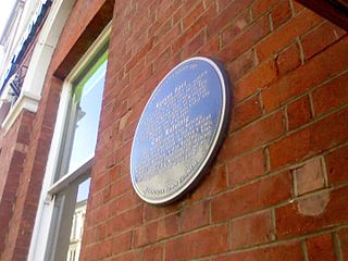
Blestium was a small fort and iron working centre in the Roman province of Britannia Superior, part of Roman Britain. It has been identified with the site of the later town of Monmouth in south east Wales, located adjoining the confluence of the River Monnow with the River Wye. A plaque on the local bank records its position.

<span class="mw-page-title-main">Venta Belgarum</span> Town in Roman Britannia

Venta Belgarum, or Venta Bulgarum, was a town in the Roman province of Britannia Superior, the civitas capital of the local tribe, the Belgae, and which later became the city of Winchester.

<span class="mw-page-title-main">Nidum</span> Roman camp at Neath, Wales

Nidum is a Roman fort found in Cwrt Herbert near the town of Neath, in Wales. An Auxiliary fort first built in around 74AD from earth banks and wooden structures, it underwent a reduction in size from 3.3 to 2.3 hectares soon afterwards. It may have been garrisoned by perhaps 500 Auxiliary troops. It was abandoned in around 125AD, but re-occupied around 140AD when it was rebuilt in stone. However it was only occupied until 170AD, with 100 years of disuse before a final period in use from AD 275 and 320.

<span class="mw-page-title-main">Kingdom of Gwent</span> Kingdom in South Wales

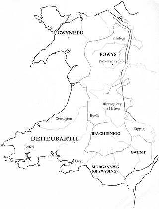
Gwent was a medieval Welsh kingdom, lying between the Rivers Wye and Usk. It existed from the end of Roman rule in Britain in about the 5th century until the Norman invasion of Wales in the 11th century. Along with its neighbour Glywyssing, it seems to have had a great deal of cultural continuity with the earlier Silures, keeping their own courts and diocese separate from the rest of Wales until their conquest by Gruffydd ap Llywelyn. Although it recovered its independence after his death in 1063, Gwent was the first of the Welsh kingdoms to be overrun following the Norman conquest.

Venta may refer to:

<span class="mw-page-title-main">Ratae Corieltauvorum</span>

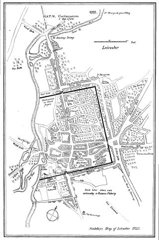
Ratae Corieltauvorum or simply Ratae was a town in the Roman province of Britannia. Today it is known as Leicester, located in the English county of Leicestershire.

<span class="mw-page-title-main">Isca Augusta</span> Former Roman site in Caerleon, Wales

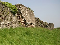
Isca, variously specified as Isca Augusta or Isca Silurum, was the site of a Roman legionary fortress and settlement or vicus, the remains of which lie beneath parts of the present-day suburban town of Caerleon in the north of the city of Newport in South Wales. The site includes Caerleon Amphitheatre and is protected by Cadw.

<span class="mw-page-title-main">National Roman Legion Museum</span> Archaeological museum in Newport, Wales

The National Roman Legion Museum (Wales) is a museum in Caerleon, near Newport, south-east Wales. It is one of three Roman sites in Caerleon, along with the Baths museum and the open-air ruins of the amphitheatre and barracks. It is part of the wider network of Amgueddfa Cymru – Museum Wales.

<span class="mw-page-title-main">Wales in the Roman era</span> Aspect of Welsh history

The Roman era in the area of modern Wales began in 48 AD, with a military invasion by the imperial governor of Roman Britain. The conquest was completed by 78 AD, and Roman rule endured until the region was abandoned in 383 AD.

<span class="mw-page-title-main">Portskewett</span> Village and community in Monmouthshire, Wales

Portskewett is a village and community (parish) in Monmouthshire, south east Wales. It is located four miles south west of Chepstow and one mile east of Caldicot, in an archaeologically sensitive part of the Caldicot Levels on the Welsh shore of the Severn Estuary. The Second Severn Crossing passes overhead carrying the M4 motorway. The community includes Sudbrook, Crick and Leechpool.

<span class="mw-page-title-main">Sudbrook, Monmouthshire</span> Human settlement in Wales

Sudbrook is a village in Monmouthshire, south east Wales. It is located 4 miles south west of Chepstow and 1 mile east of Caldicot. It lies close to the Second Severn Crossing on the Severn Estuary, and adjoins the village of Portskewett. It was largely built in the late 19th century for workers on the Severn railway tunnel. At that time it was also known as Southbrook.

<span class="mw-page-title-main">Gobannium</span>

Gobannium was a Roman fort and civil settlement or Castra established by the Roman legions invading what was to become Roman Wales and lies today under the market town of Abergavenny, Monmouthshire in south east Wales.

<span class="mw-page-title-main">Caerleon Roman Fortress and Baths</span> Archaeological museum in Newport, Wales

Caerleon Roman Fortress and Baths encompass the archaeological ruins and sites of the Legionary Fortress of Isca Augusta spread across the town of Caerleon, near the city of Newport, South Wales. Notable for being one of only three permanent legionary fortresses from Roman Britain, Caerleon has provided a unique opportunity to study the archaeology of a Roman Legionary fortress, less affected by the medieval and subsequent urban activity of most such fortresses. Having attracted the attention of eminent archaeologists throughout the 20th century it now has four major public archaeological venues, including the museum run by Cadw, called 'Caerleon Roman Fortress and Baths', featuring the excavated fortress bath-house. Also open to the public is the most complete excavated amphitheatre in Britain, a series of barracks and the National Roman Legion Museum. The fortress and its surrounding civil settlement have been the subject of continuing major archaeological investigations into the 21st century.

References

  1. "Caerwent Roman City; Venta Silurum (93753)". Coflein. RCAHMW . Retrieved 23 February 2019.
  2. Photograph of church
  3. 1 2 3 4 Miranda Aldhouse-Green and Ray Howell (eds.), Gwent In Prehistory and Early History: The Gwent County History Vol.1, 2004, ISBN   0-7083-1826-6
  4. Newman, John (2000). The Buildings of Wales: Gwent/Monmouthshire. ISBN   0-14-071053-1.
  5. Ray Howell, "From the fifth to the seventh century", in The Gwent County History Volume 1: Gwent in Prehistory and Early History, University of Wales Press, 2004, p.244
  6. Morgan, Octavius (1882). Goldcliff and the Ancient Roman Inscribed Stone Found There 1878. Monmouthshire & Caerleon Antiquarian Association.
  7. Wessex Archaeology, Caerwent Roman Town, Monmouthshire, South Wales Archaeological Evaluation and Assessment of Results, Report reference: 68736.01 February 2009
  8. Time Team
  9. Photograph of temple foundations
  10. Caerwent at Roman-Sites.com Archived 2011-07-15 at the Wayback Machine