Milecastle 29

Last updated

Milecastle 29
Northumberland, England
(The site of ) Milecastle 29 - Tower Tye - geograph.org.uk - 1129286.jpg
The site of Milecastle 29
Northumberland UK location map.svg
Red pog.svg
Milecastle 29
Location in Northumberland
Coordinates 55°02′03″N2°10′32″W / 55.034267°N 2.175435°W / 55.034267; -2.175435
Grid reference NY88887109

Milecastle 29 (Tower Tye) was a milecastle of the Roman Hadrian's Wall. Its remains exist as a mutilated earth platform accentuated by deep robber-trenches around all sides, and are located beside the B6318 Military Road. Like Milecastles 9, 23, 25, and 51, a ditch has been identified around the Milecastle, and is still visible to a small extent. It has been postulated that this was as a result of the need for drainage on the site. [1]

Contents

Construction

Milecastle 29 was a long-axis milecastle though the gateway type cannot be identified. Such milecastles were thought to have been constructed by the legio VI Victrix who were based in Eboracum (York), or by the legio XX Valeria Victrix who were based in Deva Victrix (Chester). [2]

The milecastle was stated in 1840 as having dimensions of 63 feet (19 m) North-South by 58 feet (18 m) East-West with both southern corners (away from the wall) being rounded off. [3]

The presence of a milecastle ditch is still evident, including a causeway crossing the ditch opposite the milecastle's south gate. A break in the north mound of the vallum and causeway over the vallum ditch (offset to the east) is also present. There is also disputable evidence of a causeway over the wall ditch opposite the milecastle's north gate. [3]

Excavations and investigations

Associated turrets

Each milecastle on Hadrian's Wall had two associated turret structures. These turrets were positioned approximately one-third and two-thirds of a Roman mile to the west of the Milecastle, and would probably have been manned by part of the milecastle's garrison. The turrets associated with Milecastle 29 are known as Turret 29A and Turret 29B.

Turret 29A at Black Carts Black Carts Turret - geograph.org.uk - 1582514.jpg
Turret 29A at Black Carts
Join of the turret 29A's wing wall (broad gauge) to the narrow gauge curtain wall Turret 29a - Black Carts (4) - geograph.org.uk - 1172650.jpg
Join of the turret 29A's wing wall (broad gauge) to the narrow gauge curtain wall

Turret 29A

Turret 29A (Black Carts) is located about 100 metres (110 yd) east of the minor road to Simonburn, and exists within a 460 metres (500 yd) long stretch of extant curtain wall of Narrow gauge at this point, with clearly visible foundation stones. (The term 'carts' within the name is derived from the old English word ceart, which means rocky and rough. [8] ) Although severely robbed on the south side, the masonry stands up to eleven courses high in the recess. [9] The presence of the broad wing walls indicates that the fortification was constructed prior to Hadrian's Wall itself. [8] The upright portions of the door frame are made from solitary stones. [10] [11] At the highest point of the structure, there are fourteen cut stones per horizontal row. [10]

The internal measurements of the turret are 3.45 metres (11.3 ft) by 3.40 metres (11.2 ft) and it is of a type thought to have been built by the Legio XX Valeria Victrix. The entrance is 0.9 metres (3.0 ft) wide, and located in the east side of the south wall. [3] [9]

On the south side, the vallum is still visible. [12]

The turret was excavated in 1873, 1912 and finally in 1971, prior to being consolidated by the Department of the Environment. During these excavations, fragments of millstones were found, along with coins of Vespasian, Trajan, Hadrian and Constantine (in quantities higher than are usually recovered). [3] [9]

Location on Ordnance Survey 1:25 000 map: 55°02′10″N2°10′57″W / 55.036009°N 2.182452°W / 55.036009; -2.182452 (Turret 29A)

The site of Turret 29B (The site of) Turret 29b - geograph.org.uk - 1129255.jpg
The site of Turret 29B

Turret 29B

Turret 29B (Limestone Bank) remains as a low earthwork, turf covered with little (if any) visible masonry. The track connecting the turret to the Military Way can also be discerned. [13]

Excavations in 1912 revealed the turret to have wing walls, and a very similar layout to Turet 29A. Roofing slabs (many pierced by nails) were found among debris inside the turret, along with three large flagstones, possibly from an upper floor. Below these were two occupation levels. The later floor was of flags, and the original, clay. On the south-west corner, on the later floor, a masonry platform had been constructed. Beside the east wall, an amphora had been set into the clay and cobbles, while a hearth lay against the west wall. The following artefacts were also discovered: [3]

  • Shield boss
  • Spear head
  • Brooches
  • Melon Bead
  • Gaming board
  • Millstone fragments
  • 2 Flints
  • Pottery revealing that occupation did not extend beyond the second century AD

Location on Ordnance Survey 1:25 000 map: 55°02′15″N2°11′22″W / 55.037481°N 2.189484°W / 55.037481; -2.189484 (Turret 29B)

Monument records

MonumentMonument Number English Heritage Archive Number
Milecastle 2916683NY 87 SE 3
Turret 29A16686NY 87 SE 4
Turret 29B16689NY 87 SE 5

Public access

The Milecastle and both turrets are accessible from the Hadrian's Wall National Trail.

Related Research Articles

<span class="mw-page-title-main">Milecastle 18</span>

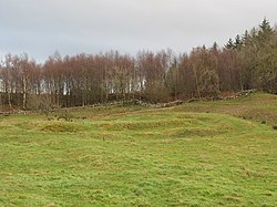
Milecastle 18 (East Wallhouses) was a milecastle of the Roman Hadrian's Wall. It is located to the west of the settlement of East Wallhouses in Northumberland and is visible as a platform in the ground. The milecastle is of a unique construction, having a gateway associated with builders of the Legio II Augusta and a layout typical of the Legio VI Victrix or Legio XX Valeria Victrix. Historians have suggested that it may have been begun by men of one legion and finished by those of another. One of Milecastle 18's associated turrets shows evidence of being used as a workshop, possibly for the repair of shoes.

<span class="mw-page-title-main">Milecastle 9</span>

Milecastle 9 (Chapel House) was a milecastle of the Roman Hadrian's Wall. Its remains exist partially as a low platform, and are located in West Denton (to the west of Newcastle upon Tyne), 300 yards (270 m) from Chapel House Farm. However, the northern part of the remains are now mostly covered by the modern roads (A69/B6528). The milecastle marks a watershed between those with relatively well-defined positions (to the west) and those whose position are less certain (to the east).

<span class="mw-page-title-main">Milecastle 10</span>

Milecastle 10 (Walbottle Dene) was a milecastle of the Roman Hadrian's Wall. It is located near to the modern village of Throckley in Tyne and Wear, northern England. Much of the milecastle lies beneath a road but partial remains of the north wall can be seen in the garden of Dene House. It has been excavated several times and its walls located, though the remains have been "considerably damaged by ploughing". Only one of the two associated turrets has been located and excavated.

<span class="mw-page-title-main">Milecastle 12</span>

Milecastle 12 (Heddon) was a milecastle of the Roman Hadrian's Wall. Its remains lay under Town Farm, Heddon-on-the-Wall, (just opposite the farm house) with nothing visible on the surface.

<span class="mw-page-title-main">Milecastle 13</span>

Milecastle 13 (Rudchester Burn) was a milecastle of the Roman Hadrian's Wall. Its remains exist as a low platform south of the B6318 Military Road.

<span class="mw-page-title-main">Milecastle 15</span>

Milecastle 15 (Whitchester) was a milecastle of the Roman Hadrian's Wall. Its remains exist as a bold platform with robbed walls located on the southern side of the B6318 Military Road approximately 3 kilometres (1.9 mi) west of its crossing of the A69 road. It has not been excavated.

<span class="mw-page-title-main">Milecastle 19</span>

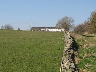
Milecastle 19 (Matfen Piers) was a milecastle of the Roman Hadrian's Wall. Sited just to the east of the hamlet of Matfen Piers, the milecastle is today covered by the B6318 Military Road. The milecastle is notable for the discovery of an altar by Eric Birley in the 1930s. An inscription on the altar is one of the few dedications to a mother goddess found in Roman Britain, and was made by members of the First Cohort of Varduli from northern Spain. The presence of the Vardulians at this milecastle has led to debate amongst archaeologists over the origins of troops used to garrison the wall. A smaller altar was found at one of the two associated turrets.

<span class="mw-page-title-main">Milecastle 22</span>

Milecastle 22 (Portgate) was a milecastle of the Roman Hadrian's Wall. Its remains exist as a low, turf covered platform just east of the Portgate roundabout (junction of the A68 and B6318). The platform is 0.5 metres (1.6 ft) on the east side, reducing to only a parch mark on the west side.

<span class="mw-page-title-main">Milecastle 23</span> Milecastle in Northumberland, England, UK

Milecastle 23 (Stanley) was a milecastle of the Roman Hadrian's Wall. Its remains exist as a low, grass covered platform with traces of an external ditch (as Milecastle 25). It is located to the south of the B6318 Military Road around 1.5 kilometres (0.93 mi) west of its junction with the A68.

<span class="mw-page-title-main">Milecastle 78</span>

Milecastle 78 (Kirkland) was one of a series of Milecastles or small fortlets built at intervals of approximately one Roman mile along Hadrian's Wall (grid reference NY245613).

<span class="mw-page-title-main">Milecastle 24</span>

Milecastle 24 (Wall Fell) was a milecastle of the Roman Hadrian's Wall. Its remains exist as a low platform, and are located to the south of the B6318 Military Road around 3 kilometres (1.9 mi) west of its junction with the A68.

<span class="mw-page-title-main">Milecastle 25</span>

Milecastle 25 (Codlawhill) was a milecastle of the Roman Hadrian's Wall. Its remains exist as a low platform, and are located to the south of the B6318 Military Road (about 1 metre (3.3 ft) high), nearly 5 kilometres (3.1 mi) to the west of its junction with the A68.

<span class="mw-page-title-main">Milecastle 26</span>

Milecastle 26 (Planetrees) was a milecastle of the Roman Hadrian's Wall. Its position is slightly to the south of, but mostly covered by the B6318 Military Road., and it is located around 700 metres (0.43 mi) east of the B6318 Military Road's junction with the A6079. No visible traces exist currently. The dimensions are the same as Milecastles 23, 24, and 25.

<span class="mw-page-title-main">Milecastle 28</span>

Milecastle 28 (Walwick) was a milecastle of the Roman Hadrian's Wall in England. No remains are currently visible. Its location is immediately to the south of the B6318 Military Road in Walwick.

<span class="mw-page-title-main">Milecastle 30</span>

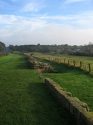
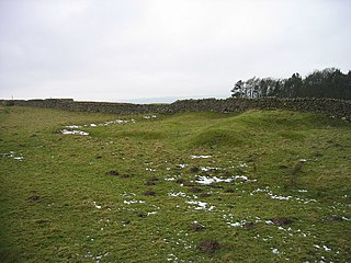
Milecastle 30 (Limestone Corner) was a milecastle of the Roman Hadrian's Wall. Its remains exist as an outward-facing scarp with a maximum height of 0.8 metres (2.6 ft). Masonry from the east wall (both faces) remains in situ. The remaining stretch is 3.1 metres (10 ft) in length by 2.25 metres (7.4 ft) thick, and survives to a height of 0.6 metres (2.0 ft). It is located at the western part of Limestone Corner, just off the B6318 Military Road.

<span class="mw-page-title-main">Milecastle 31</span>

Milecastle 31 (Carrawburgh) was a milecastle of the Roman Hadrian's Wall. Its remains exist as a turf covered platform beside (and partially covered by) the B6318 Military Road, just to the east of Carrawburgh fort (adjoining the car park).

<span class="mw-page-title-main">Milecastle 32</span>

Milecastle 32 (Carraw) was a milecastle of the Roman Hadrian's Wall. Its remains exist as earthworks and with no exposed masonry. The layout of the milecastle walls is defined (still quite evident) by robber trenches (to a maximum depth of 0.3 metres (1 ft 0 in). The north wall is beneath a modern wall.

<span class="mw-page-title-main">Milecastle 33</span>

Milecastle 33 (Shield on the Wall) was a milecastle of the Roman Hadrian's Wall, one of a series of small fortlets built at intervals of approximately one Roman mile along the length of the UNESCO World Heritage Site in northern England.

<span class="mw-page-title-main">Milecastle 34</span>

Milecastle 34 (Grindon) was a milecastle of the Roman Hadrian's Wall. There are no visible remains, but the site is within a small, tree-filled, walled enclosure located around 0.5 kilometres (0.31 mi) east of Sewingshields farm.

<span class="mw-page-title-main">Milecastle 50TW</span>

Milecastle 50TW (High House) was a milecastle on the Turf Wall section of Hadrian's Wall (grid reference NY60716583). The milecastle is located close to the Birdoswald Roman Fort and is unique in that it was not replaced by a stone milecastle when the turf wall was upgraded to stone, the replacement wall instead running some 200m to the north. The milecastle was partially demolished by the Romans after it was abandoned. The milecastle was excavated in 1934 and several Roman rubbish pits discovered. The remains of the two turrets associated with this milecastle (which were demolished when the turf wall was abandoned) have also been located. As the turf wall lies some distance from the stone wall, the sites are not accessible from the Hadrian's Wall Path.

References

  1. 1 2 Historic England. "Milecastle 29 (16683)". Research records (formerly PastScape). Retrieved 21 February 2012.
  2. David J Breeze and Brian Dobson (1976). Hadrian's Wall. Allen Lane. pp. 14–15. ISBN   0-14-027182-1.
  3. 1 2 3 4 5 Breeze, David J (1934), Handbook to the Roman Wall (14th Revised edition – Nov 2006), Society of Antiquaries of Newcastle upon Tyne, pp. 211–212, ISBN   0-901082-65-1
  4. Horsley, John (1732), Britannia Romana or the Roman Antiquities of Britain, Frank Graham (published 1974), p. 145, ISBN   0-85983-090-X
  5. Hodgson, Rev John (1840), A History of Northumberland, Part II, Vol III, Newcastle upon Tyne, p. 279
  6. Maclauchlan, Henry (1858), Memoir Written During A Survey Of The Roman Wall: Through The Counties Of Northumberland And Cumberland, In The Years 1852–1854, Kessinger Publishing Co, p. 95, ISBN   1-4370-5803-5
  7. Bruce, J Collingwood (1957), Handbook to the Roman Wall (11th edition), Society of Antiquaries of Newcastle upon Tyne, p. 101
  8. 1 2 Nic Fields (2003), Hadrian's Wall AD 122–410, vol. 2, Osprey Publishing, ISBN   978-1-84176-430-6
  9. 1 2 3 Historic England. "Turret 29A (16686)". Research records (formerly PastScape). Retrieved 22 February 2012.
  10. 1 2 David E. Johnston (2002), Discovering Roman Britain (3 ed.), Osprey Publishing, ISBN   978-0-7478-0452-9
  11. Martin Marix Evans (1998), The military heritage of Britain & Ireland , André Deutsch, ISBN   978-0-233-99150-4
  12. Lord Montagu of Beaulieu (1987), P.H. Reed (ed.), English Heritage, Hampstead Road, London: English Heritage / Macdonald Queen Anne Press, p. 31, ISBN   0-356-12773-7
  13. Historic England. "Turret 29B (16689)". Research records (formerly PastScape). Retrieved 22 February 2012.

Bibliography