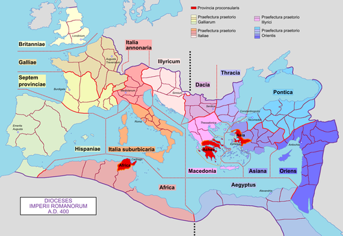
Roman Empire in 125 AD near its maximum extentNorthern Frontiers in 337 AD showing the reconquests of Constantine the GreatRoman Empire with dioceses in 400 AD
The Roman frontier stretched for more than 5,000 kilometres (3,100mi) from the Atlantic coast of northern Britain, through Europe to the Black Sea, and from there to the Red Sea and across North Africa to the Atlantic coast. The positions of the borders changed especially during the main periods of Roman expansion and contraction, and first became more stable during the early Empire period under Augustus, but the borders continued to change with time in different provinces. The borders had different constituents depending on local needs; often they consisted of natural boundaries (e.g. rivers) with roads behind for easier movement of troops between linked forts (e.g. Danubian Limes), or else roads with linked forts (e.g. Stanegate, Fosse Way).
The remains of the frontiers today consist of vestiges of roads, forts, fortresses, walls and ditches, and associated civilian settlements. The soldiers at a border were referred to as limitanei.[citation needed] They were not expected to win large-scale wars, but rather to deter small-to-medium-sized raiding parties.
The stem of limes, limit-, which can be seen in the genitive case, limitis, marks it as the ancestor of an entire group of words in many languages related to Latin; for example, English limit or French limite. The Latin noun līmes (English: /ˈlaɪmiːz/;[5] Latin pl.līmitēs) had a number of different meanings: a path or balk delimiting fields; a boundary line or marker; any road or path; any channel, such as a stream channel; or any distinction or difference.[6] The term was also commonly used after the 3rd century AD to denote a military district under the command of a dux limitis.[7]
An etymology by Julius Pokorny in Indogermanisches Etymologisches Wörterbuch says that limes comes from Indo-Europeanel-, elei-, lei-, "to bow", "to bend", "elbow". According to Pokorny, Latin limen, "threshold", is related to limes, being the stone over which one enters or leaves the house. Some scholars have viewed the frontier as a threshold. The Merriam–Webster dictionaries take this view, as does J. B. Hofmann in Etymologisches Wörterbuch des Griechischen under leimon. The White Latin Dictionary denies any connection, deriving limen from *ligmen, as in lien from *leig-, "tie". In this sense, the threshold ties together the doorway. W. Gebert also wrote an article discussing the term.[8]
The first use of the term limes[9] as meaning "land border" appears for the first time in 98 AD by Tacitus:[10][11]
...nec iam de limite imperii et ripa, sed de hibernis legionum et de possessione dubitatum (...not only were the frontier of the empire and the banks [of the Danube] in danger but also the winter-quarters of the legions and the provinces).
Its definitive use for the Danubian border seems to date from about 122 in the time of Hadrian:[12]
Per ea tempora et alia frequenter in plurimis locis, in quibus barbari non fluminibus sed limitibus dividuntur, stipitibus magnis in modum muralis saepis funditus iactis atque conexis barbaros separavit (During this period and on many other occasions also, in many regions where the barbarians are held back not by rivers but artificial barriers, [Hadrian] shut them out by tall stakes planted deep in the ground and fastened together in the manner of a palisade).
Some experts suggested that the Germanic limes may have been called Munimentum Traiani (Trajan's Bulwark) by contemporaries, referring to a passage by Ammianus Marcellinus, according to which emperor Julian had reoccupied this fortification in 360 AD.[13]
Meaning of limes as a form of barrier
The limes was classified according to the way they functioned as a barrier: natural, artificial, or internal.
Natural barriers
In the first case the barriers, which divided the Roman world from the barbarians or from other foreign states, could be:
of a fluvial type (such as the Rhine, Danube and Euphrates) and called ripa (in the sense of a riverbank);[14]
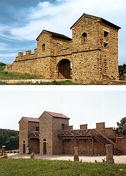
In the second case the barriers were built artificially by human labour, with an earth agger, a palisade or a stone wall (especially from the time of Hadrian), and a ditch in front, as in the case of Hadrian's Wall, Antonine Wall, the Porolissensis or the Germanic-Rhaetian limes. Each frontier was also followed in parallel along its entire length by a road guarded at regular intervals not only by legionary fortresses (castra), but also by forts (castella) and small forts (burgi) of the auxiliaries, as well as towers (turris) and observation posts (stationes).
Depictions of the Roman limes can be seen in the friezes of Trajan's Column and that of Marcus Aurelius, where the opening scenes represent the right bank of the Danube, with a whole series of guard posts, forts and fortresses, defended by palisades, stacks of wood and sheaves of straw which, if set on fire, served as signals.
A people [that of the Romans] that evaluates situations before taking action and that, once it has decided, possesses such an efficient Roman army: is it surprising that the frontiers of its empire are marked, in the East by the Euphrates, by the ocean in the West, to the north by the Danube and the Rhine? Without exaggeration, we might say that their conquests are inferior to their conquerors.
There were three main strategic sectors protecting the Roman Empire:
the first and most important, which later determined the fall of the Western Roman Empire in the 5th century, was the northern front, itself composed of:
the Danubian limes, the most important of the entire imperial defensive system, protecting all the provinces which from Raetia ran along the great river to its mouth, with Moesia Inferior.
the limes north of the Danube, including the Dacian provinces, Sarmatia and the northern coasts of the Black Sea (the Greek cities of Tyras and Olbia, the Bosporan Kingdom, all locations garrisoned since the time of Nero with Roman military installations, until the arrival of the Goths in the first half of the 3rd century).
the second in importance, namely the eastern limes, protecting the eastern frontiers of the Roman Empire, was organized into four sub-sectors:
the so-called Limes Arabicus which connected the Euphrates to the Red Sea over about 1,000 km, itself divided into two sub-limes, defending the provinces of Syria, Arabia and Judaea/Palestine.
the third in importance, although the longest to defend, was the African limes protecting the southern frontiers. It was in turn divided into two macro-sectors:
The frontier in Britain existed from the 1st to the 5th century AD. Initially the Fosse Way road was a frontier. From the 1st to the 2nd century first the Gask Ridge and then the Stanegate, with their chains of forts and watchtowers, marked the northern boundary of Britannia. Later Hadrian's Wall was built as the frontier and for a short time the Antonine Wall further north. The defence of Hadrian's Wall was achieved through the incorporation of forts and castella. Security and monitoring on the coasts in the west and southeast were achieved by forts and by chains of watchtowers or signal towers, both along the coastline.
The garrisons, Exercitus Britannicus[citation needed], consisted mostly of cohorts of auxilia. The strategic reserve comprised three legions based in Eburacum (York), Isca Silurum and Deva. The observation and surveillance of the waters around the British Isles was the responsibility of the Classis Britannica, whose headquarters were in Rutupiae (Richborough). Legions, auxilia and the fleet were commanded by the provincial governors. From the 3rd century, units of comitatenses, limitanei and liburnaria (marines) came under the command of two generals:[citation needed]
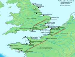
This limes of the Late Antiquity ran through the territory of the present-day United Kingdom and France. In the 3rd century, a separate military district, the Litus Saxonicum,[citation needed] was established on the British side of the English Channel between the estuaries of the Wash and the Solent, to repel Saxon pirates and plunderers. The Gallic side of the English Channel and Atlantic coast were included therein. Monitoring and coastal surveillance were carried out by a chain of watchtowers or signal towers, forts and fortified ports (Gaul). Most of the Saxon Shore camps probably served as naval bases.[citation needed]
The garrisons of the forts were composed of infantry and several cavalry regiments. Monitoring and surveillance of the Channel were the responsibility of the Classis Britannica and Classis Sambrica, whose headquarters were in Locus Quartensis (Port d'Etaple), guarding the mouth of the River Somme. The units of comitatenses, limitanei and liburnaria in this area came under the command of three generals:
This section of limes existed from the 1st to the 5th century AD and ran through the province of Lower Germania (Germania Inferior).
The conquest of Gaul by Julius Caesar (58–51 BC) established a new frontier for the territories of the Roman Republic: the river Rhine, beyond which lay the lands of the Germanic peoples. With the rise of Augustus, the plans of the first Roman emperor changed. He intended to move the limes further east, beyond the Rhine to the Elbe. Beginning in 12 BC, a whole series of campaigns was launched in Germany through three or four different lines of advance.
The occupation by Roman armies brought under the rule of Rome first the Germanic territories between the Rhine and the Weser (also with the construction of roads and bridges, the so-called pontes longi), and from AD 5 onward also those further east, between the Weser and the Elbe. It was only after the disaster of Teutoburg in AD 9 that the plans of the princeps Augustus changed and the Roman armies were definitively withdrawn, bringing the limes once again back to the Rhine. Germania was definitively lost. No later emperor would again plan its conquest. Even today the Rhine marks the line of demarcation between two different European language families: the neo-Latin and the Germanic.
Under Domitian, because of the continual wars against the Dacians of Decebalus, the Rhine lost its primacy as the most important strategic sector, in favour of the Danubian sector, followed by the conquest of Dacia by Trajan (101–106). The following century saw continuous maintenance of this stretch of the Rhine frontier. We know that around 170–172 there were attacks by the Germanic tribe of the Chauci along the shores of Gallia Belgica during the period of the Marcomannic Wars. The first real mass incursions began in the 3rd century, so much so that Gallienus was forced around 260 to abandon the so-called Agri Decumates, that is, the most northerly sector of the limes of Germania Inferior. Every fort between the mouth of the Rhine and the tributary Waal was abandoned. The strategic error was considerable, since once the Germanic peoples were allowed to penetrate this side of the Rhine, it became clear how vulnerable the frontier of Gaul was to repeated barbarian attacks.
Following the devastating invasions of the Franks in 275 and 276, a new fortified limes was constructed, linking the Gallic coast via Bavay and Tongeren to Nijmegen on the Rhine. After these events, Gaul enjoyed a period of relative peace, at least until the usurpation of Magnentius in 350. The withdrawal of a large part of the Roman troops along the Rhine by Stilicho in 401, in order to repel the Visigoths of Alaric from Italy, allowed new and devastating barbarian invasions by Suebi, Vandals, Burgundians and Alans, with the consequent loss of much of the Gallic territories (406). Some of the invaders were in fact allowed to remain within imperial borders with the status of foederati, such as the Visigoths in Aquitania or the Burgundians in Burgundy, etc. The integrity of the frontiers had definitively broken down and the Rhenish sector was now in collapse.
It lies on the territory of today's Netherlands and Germany. This limes was a river border (limes ripa) on the Rhine, defended by a chain of camps, that ran from the North Sea (Katwijk-Brittenburg camp) to Vinxtbach (opposite Rheinbrohl fort on the Upper Germanic Limes), forming the border between the Roman provinces of Germania Inferior and Germania Superior. By contrast with the Upper Germanic-Rhaetian Limes, it was not marked by a solid palisade or wall. Neither can any defensive ditch or rampart be identified. The guards were stationed in nearby castra and watchtowers usually built immediately on the Rhine. The limes was served by a well-developed military road. Each camp had its own river port or landing stage and a storage area, because the Rhine not only formed the border but was also the most important transport and trade route in the region. In the first section, between the camps of Rigomagus (Remagen) and Bonna (Bonn), there were only a few camps. In the second, middle, section between Bonna and Ulpia Noviomagus Batavorum (Nijmegen), there were considerably more. Here there were also larger legion camps; with one exception, all were cavalry barracks. The landscape of the third section between Ulpia Noviomagus Batavorum and Mare Germanicum (the North Sea) was characterised by numerous small streams and boggy marshland. Consequently, in this area there was only one cavalry camp. Border security here consisted mainly of tightly packed, relatively small cohort forts.
The occupying troops, Exercitus Germaniae Inferioris, consisted mostly of auxilia cohorts. From the 2nd century, the strategic reserve comprised three legions stationed in Bonna/Bonn, Novaesium/Neuss, Vetera/Xanten and Noviomagus/Nijmegen. The control and surveillance of the waters of the North Sea, the Rhine estuary and the Lower Rhine was the responsibility of the Classis Germanica whose headquarters was in Colonia Claudia Ara Agrippinensium/Cologne. Legions, auxilia and fleet units were commanded by the respective provincial governor. From the 3rd century the ripenses (river guards), comitatenses, and liburnaria were under the command of the Dux Belgicae secundae.
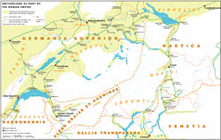
It lay on the territory of the present German states of Rhineland-Palatinate, Hesse, Baden-Württemberg and Bavaria. To the north, it bordered those parts of the Roman province of Rhaetia that lay north of the Danube and guarded the eastern border of that part of Germania Superior that lay east of the Rhine. In Upper Germania the border defences initially consisted only of a post road. From about 162/63 AD, the Romans constructed a defensive barrier with watchtowers and signal towers, palisades, ditches and earthworks. On one short section of the Rhaetian Limes, a solid stone wall was erected. In its final stages, the Upper Germanic-Rhaetian Limes was about 550 kilometres long and ran from Rheinbrohl, in the county of Neuwied in northern Rhineland-Palatinate, as far as Hienheim on the Danube. Between the villages of Osterburken and Welzheim, the limes ran for 81 kilometres almost in a straight line southwards.[15] In the scholarly literature, this unusual section is considered as evidence that this type of boundary wall had never been used for defensive purposes.
The land of Agri Decumates that was guarded by this limes had to be vacated by the Romans in 260–285 AD. They moved their bases back to the banks of the Rhine and Danube, which were much easier to defend militarily. The exact route of the limes along the border between Upper Germania and Raetia has not been fully explored. In the late 4th and early 5th centuries, the Rhaetian Limes was reorganized and divided into three sections. The northern border of Rhaetia formed the pars superior (upper part), the western border was the pars media (central part) with the fortified town of Cambodunum and bases from Vemania (Isny im Allgäu) to Cassilacum (Memmingen); the pars inferior (lower part) was the section between Castra Regina (Regensburg) and Batavis (Passau).
The defending troops, Exercitus Germaniae superioris and Exercitus Raeticus, consisted mostly of auxilia cohorts. From the 2nd century, the strategic reserve was formed from three legions stationed in Mogontiacum/Mainz, Argentorate/Strasbourg and Castra Regina/Regensburg. The monitoring of the Upper Rhine was the responsibility of the Classis Germanica; that of the Rhaetic Danube came under the Classis Pannonia, whose headquarters was in Aquincum/Budapest. Legions and auxilia cohorts were under the command of the governor. From the 3rd century the Upper Germanic-Rhaetian border troops (comitatenses, repenses, and liburnaria), were commanded by three generals:
It lies on the territory of present-day Germany, Austria, Switzerland and Liechtenstein. As early as the period 15 BC to about 70 AD, the border between Rome and Germania ran mostly along the line of the late antique Danube-Iller-Rhine Limes (DIRL) before the Romans advanced further north into the Agri decumates. Because of troop withdrawals and massive barbarian invasions, the Upper Germanic-Rhaetian Limes were abandoned in the late 3rd century and the Roman forces pulled the border back to the banks of the three rivers. Especially around the year 300, the Emperor Diocletian had new fortifications built directly on the river banks or on major roads in the hinterland here. Around 370 AD, the line of fortifications was considerably strengthened under the Emperor Valentinian I to counter the Alemanni, who were steadily advancing southwards. By contrast with the Upper Germanic-Rhaetian Limes, the DIRL primarily fulfilled defensive purposes; its camps had much stronger and higher walls than their High Imperial predecessors. Furthermore, they had in most cases been built to conform to the local topography. This meant that they could not be built in the classical 'pack of cards' shape. Between them a dense chain of watchtowers and signal towers were constructed to provide an additional security measure (burgi).
Flotillas of patrol boats were stationed on the large lakes in this region.
Lake Constance: Numerus Barcariorum (HQ at Brigantium/Bregenz)
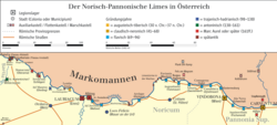
This section of the limes existed from the 1st to the 5th century AD and guarded part of the Roman province of Noricum.
It is on the soil of the present-day Austrian states of Upper and Lower Austria. It ran along the Danube from Passau/Boiodurum to Zeiselmauer/Cannabiaca. This is also a ripa (river border), which was guarded by a loose chain of cohort forts. The main road on the Norican Limes was the via iuxta amnem Danuvium. The initially simple wood and earth structures were systematically converted under Emperor Hadrian into stone encampments. During the 4th century, they were brought once more up to date and massively reinforced. Between the camps, in strategic places or good points of observation, were watchtowers or signal towers and, in the Late Antiquity, burgi. In the middle section, between the camps of Favianis and Melk, watchtowers were built only sporadically. Here the narrow valley of the Wachau, with its densely forested escarpments, made access to the riverbank more difficult, providing some defensive function. Every camp had its own river port or landing stage and a storage area because the Danube was not only a border zone, but also the most important transport and trade route in the region. Over time civilian settlements or vici were established immediately next to the camps. In the immediate hinterland of the limes, walled towns or municipia were founded – for example, Aelium Cetium or Ovilava (Wels). They were the administrative or commercial centres of the region. In late antiquity, the Norican area was divided into two parts (pars inferior and pars superior).[16] It is probable that a second, defensive line was created to the rear (Castrum Locus Felicis).
The occupying troops, Exercitus Noricus, consisted mostly of auxilia cohorts and a legion stationed in Lauriacum/Enns acted as the strategic reserve. The surveillance and security of the Danube and its tributaries were the responsibility of the Classis Pannonia. Units of the legions, naval and auxiliary forces were commanded by the respective governors. In late antiquity – according to Notitia Dignitatum – four newly established flotillas undertook this task. From the 3rd century, the Norian comitatenses, ripenses and liburnari were under the command of two generals:
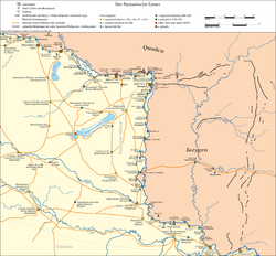
Map of the Pannonian Limes with its perimeter defences
This stretch of limes was in use from the 1st to the 5th centuries AD and helped to guard the provinces of:
Pannonia inferior
Pannonia
The Pannonian Limes is situated on the territory of present-day Austria, Slovakia and Hungary. Although this section of the frontier was relatively well protected by the Danube river border or Ripa, the Roman military presence here was always exceptionally strong (three military camps in Pannonia, but only one in Lower Pannonia) because especially after the abandonment of Roman Dacia in the late 3rd century, the pressure of migrant peoples from the east on this section of the limes intensified. The tributaries emptying into the Danube offered cheap transport routes, but also made good approach routes for invaders and raiders. The military camps were therefore built by the most important fords or confluences and road termini. The legion- and auxilia camps were mainly located in the immediate vicinity of the riverbank. The initial wood and earth structures, were systematically converted under Emperor Hadrian into stone barracks and, in the 4th century, redesigned and massively strengthened in order to match new strategic requirements. The gaps between the camps were closed by a chain of watchtowers or signal towers. In late Roman times huge inland camps were built and towns in the hinterland were fortified to create a second line of defence. In addition, at vulnerable points, units of the Danube fleet were stationed. In the time of Emperor Marcus Aurelius the first mention is made in Pannonia of stone watchtowers (burgi, panelled towers and fortlets (praesidia). In late antiquity, the Pannonian military district was divided into two parts (pars inferior and pars superior).[16] Advance defences were provided by bridgehead camps (e.g. Castra Contra Aquincum or Celemantia) and military stations on main transport routes in the Barbaricum (e.g. near Musov).
The Roman province of Asia in 127 BC, at the end of the proconsulship of Manius Aquillius, who reduced its territories in the East, beginning the construction of a road network radiating from Ephesus.
A few years later (in 111 BC), Mithridates VI, son of Mithridates V, ascended the throne of the Kingdom of Pontus. The new ruler immediately pursued (from 110 BC onward[17]) an expansionist policy in the Black Sea area, conquering all regions from Sinope to the mouths of the Danube. The young king then turned his attention to the Anatolian peninsula, where Roman power, however, was steadily growing. He knew that a clash with Rome would prove fatal for one of the two sides. At the end of the three Mithridatic Wars (89–63 BC), Rome prevailed and succeeded in annexing much of Anatolia, as far as Syria and Judaea.
A decade later, however, the Roman consul Marcus Licinius Crassus was heavily defeated at the Battle of Carrhae in 53 BC, while the Kingdom of Armenia became the theatre of contention between Rome and the Parthian Empire. The Parthians in fact forced Armenia into submission from 47 BC to 37 BC. Although the subsequent campaigns in Parthia proved unsuccessful (with 30,000 soldiers lost), the Armenian kingdom returned to being a client state of Rome from 34/33 BC onward.
The eastern situation was destabilized by the deaths of the king of CappadociaArchelaus, who had come to Rome to pay homage to the new princeps, Tiberius, as well as Antiochus III, king of Commagene, and Philopator, king of Cilicia. The difficult eastern situation thus required a new Roman intervention, and in 18 Tiberius sent his adopted son Germanicus who, with Parthian consent, crowned at Artaxata the young Zeno, son of Polemon I and strongly pro-Roman, as king of Armenia.[20] He also established that Cappadocia should be constituted as its own province, and that Cilicia should instead be incorporated into the province of Syria.[21] Following the annexation of Cappadocia under Tiberius (17/18), a number of military forts were placed along the Euphrates to guard the northern sector of the eastern frontier.
After the death of Tiberius in 37, the Parthians forced Armenia to submit,[22] although it appears that in 47 the Romans regained control of the kingdom and granted it the status of client state. The situation remained fluid. Nero, concerned that the Parthian king Vologases I had placed his brother Tiridates on the Armenian throne, decided to send his capable general Gnaeus Domitius Corbulo in command of eastern operations. Corbulo reached a final agreement with the "King of Kings" in 63, restoring Roman prestige and concluding with Tiridates an arrangement that recognized Armenia as a Roman protectorate, which remained largely unchanged until the reign of Trajan.
In 113, Trajan decided to proceed with the invasion of the Parthian kingdom. The motive was the need to restore to the throne of Armenia a king who was not a puppet of the Parthian ruler. Armenia was invaded by the army commanded by the emperor Trajan himself in 114, who captured its capital Artaxata. Having deposed its king, Parthamasiris, he annexed its territories to the Roman Empire, making it for the first time a new province. His successor Hadrian adopted instead a policy of strengthening the old borders west of the Euphrates, while the conquests east of the river were abandoned. In the years that followed, around 141-143, the emperor Antoninus Pius placed on the Armenian throne a new pro-Roman king, Sohaemus.
The new Parthian ruler Vologases IV, since in 161 the Armenian throne had become vacant and was claimed by Sohaemus, a prince of Emesa (who was also a Roman senator), reacted by sending cavalry under the general Osroes, who inflicted a severe defeat on the Romans. Sohaemus was deposed and forced to flee, while Armenia, now in Parthian hands, received a new king named Pacorus. The governor of Cappadocia, Severianus, marched with his army into Armenia but was defeated at Elegeia just east of the Euphrates. The campaigns that followed, conducted by Lucius Verus, however led to the annexation of the kingdom together with northern Mesopotamia (162–166).
From 230 to 260, the new Sasanian dynasty, which replaced the Arsacids, severely tested the Roman frontier along the upper Euphrates, so that Armenia passed under Persian influence. The Romans succeeded in reconquering the Armenian kingdom at the end of years of war (296–298) in the time of Diocletian (Augustus) and Galerius (Caesar). Mesopotamia also returned under Roman control. But in 334 the Armenian king was captured and taken to Persia, forcing the Armenians to call upon Constantine the Great.[24] Constantine wrote to the great king Shapur II, who after long negotiations decided to annex Armenia and threatened the neighbouring Roman province of Mesopotamia. Constantine, however, died shortly afterwards (337), and his role was taken by his son Constantius II, who was forced to fight repeatedly against the Sasanians for about twenty-five years, until the disastrous campaign of 363.
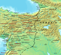
The Roman–Persian frontier after the partition of Armenia in 384. The frontier remained stable throughout the 5th century.
The new emperor Jovian was forced to sign a treaty with Shapur II (364) granting the Sasanians major territorial gains and allowing the Roman army to withdraw safely. Soon afterwards Shapur turned his attention to Armenia, capturing its king Arsaces II, a loyal Roman ally, and forcing him to commit suicide. In 384 Armenia was finally divided into two regions, the western under the Eastern Roman Empire and the eastern entrusted to the Sasanians. The western region became a Roman province named Armenia Minor, while the eastern part remained a kingdom within Persia until 428, when the Sasanians deposed the legitimate ruler and installed their own dynasty. The frontiers along the Euphrates remained largely unchanged until the Arab invasions beginning in the 7th century.
East of the Euphrates: Mesopotamia and Osroene
The lands beyond the Euphrates were first conquered by Trajan in 115 during the campaigns against the Parthian Empire. The territories of Mesopotamia and Osroene were, however, abandoned only a few years later by his successor Hadrian in 117. Northern Mesopotamia returned again under Roman control following the Parthian campaigns of Lucius Verus, at least until the reign of Commodus. Lost around 192, it was reconquered by Septimius Severus in 197 and placed under the authority of the newly created praefectus Mesopotamiae.
Between 224 and 226/227 an important event occurred that changed the course of relations between the Roman Empire and the Sasanian Empire: in the East the last Parthian ruler Artabanus IV was overthrown after being defeated in "three battles"[25] and the rebel Ardashir I founded the Sasanian dynasty,[26] destined to be Rome's eastern adversary until the 7th century.[27]
An initial breakthrough of the Roman Mesopotamian frontier occurred repeatedly by the armies first of Ardashir I (229–241) and then of his son Shapur I (241–260), followed by Roman counter-offensives led by emperors such as Severus Alexander, Gordian III and Valerian. The latter, however, was defeated in battle in 260 at Battle of Edessa and captured by the "King of Kings", allowing Sasanian forces once again to plunder the Roman territories of Mesopotamia, Syria and Cappadocia, and causing the destruction of many positions along the eastern frontier.
After the death of Valerian, although the Roman Empire was under constant pressure from the Germanic-Sarmatian invasions along the northern frontier, it was forced to react to the terrible defeat of 260, which had led to the subsequent occupation of Antioch, the third largest Roman city after Rome and Alexandria. From this moment onward, for the following forty years, Roman armies advanced on at least three occasions deep into Sasanian territory, capturing their capital Ctesiphon each time: first under Odaenathus (rector totius Orientis), then under the emperors Carus and Numerian, and finally under Galerius under the supervision of Diocletian.
At the end of these campaigns, Mesopotamia returned under Roman control, Armenia was recognized as a Roman protectorate, and at Nisibis the caravan routes of trade with the Far East (China and India) were concentrated. With the control of certain territories east of the Tigris, the empire reached its greatest eastern expansion (298).[28] The entire eastern frontier system was therefore strengthened, beginning with the construction of the Strata Diocletiana in Syria and new fortified positions throughout Mesopotamia and Osroene.
The eastern frontiers in the time of Constantine the Great, with the territories acquired during the thirty years of campaigns (306–337).
The peace treaty between Diocletian and the Sasanian king Narseh lasted almost forty years. The Sasanian defeat at the hands of Diocletian and Galerius (peace of 298) guaranteed the Roman Empire more than thirty years of relative peace (until 334), and northern Mesopotamia returned under Roman control. The frontier was in fact moved as far as the Khabur and the northern Tigris, passing through the Sinjar Mountains.[29]
The years following the death of Constantine (337) were extremely difficult for the two empires, engaged in a constant war of attrition without clear winners: on one side Constantius II (who spent much of his time between 337 and 350 at Antioch, which became the headquarters of the eastern armies), on the other Shapur II (attempting to expel the Romans from all Asian territories west of the Euphrates). In the end the borders remained essentially stable, with advances and retreats on both sides, at least until the campaign of 363, when Roman armies were forced to cede much of the territory east of the Euphrates, thereby abandoning almost two and a half centuries of conquests.
The Limes Arabicus was the frontier of the Roman province of Arabia Petraea, facing the desert. It runs from the Gulf of Aqaba in southern Palestine to northern Syria, for about 1,500 kilometers (930mi) at its greatest extent. The purpose of this defensive limes was to protect the Roman province of Arabia from attacks by the barbarian tribes of the Arabian desert. "For over five centuries the Limes Arabicus protected the south-eastern frontier of the Roman Empire".[30]
In 67 BC Pompey was appointed commander of a special fleet to conduct a campaign against the pirates infesting the Mediterranean Sea, with broad powers that ensured his absolute control over the sea and also over the coasts for 50 miles inland, placing him above every military commander in the East. In just three short months (67 BC), Pompey’s forces literally cleared the Mediterranean of pirates, wresting from them the island of Crete and the coasts of Lycia, Pamphylia and Cilicia, demonstrating extraordinary precision, discipline and organizational ability.
He was then entrusted with bringing the Third Mithridatic War to an end against Mithridates VI of Pontus. This command essentially gave Pompey responsibility for the conquest and reorganization of the entire eastern Mediterranean. He conducted the campaigns from 65 BC, destroying the armies of Mithridates and Tigranes the Great, king of Armenia, with whom he later concluded a peace favourable to Rome. He then occupied Syria, then under the rule of Antiochus XIII (last of the Seleucids), before moving on to Jerusalem, which he captured in a short time. Pompey imposed a general reorganization of the East, establishing new provinces and client states, taking into account both geographical and political factors connected to the creation of a new eastern frontier that relied on Tigranes as a key supporting ally for extending Roman influence eastward to the Black Sea and the Caucasus.
Augustus' presence in the East immediately after the Battle of Actium (30–29 BC) and again from 22 to 19BC, as well as that of Marcus Vipsanius Agrippa between 23–21 BC and again between 16–13 BC, demonstrated the importance of this strategic sector. It was necessary to reach a modus vivendi with Parthia, the only power capable of challenging Rome along the eastern frontiers. In practice both empires had more to lose from defeat than they could realistically gain from victory. Parthia therefore accepted that west of the Euphrates Rome would organize states as it pleased:[31] Augustus thus incorporated some client states into Roman provinces (such as Judaea of Herod Archelaus in 6, after disturbances at the death of Herod the Great in 4 BC) and strengthened older alliances with local rulers who now became "client kings of Rome", as occurred with the rulers of Emesa, Iturea,[32]Commagene, Cilicia and Nabataea.[33]
While still preparing to conquer Dacia, Trajan arranged the annexation of Arabia Petraea (105–106), and in the following years ordered the construction of an important frontier military road: the Via Traiana Nova (between 111 and 114), which linked Aelana on the Red Sea with the legionary fortress of Bostra, 267 Roman miles away. Its primary purpose was to provide an efficient means for transporting troops and government officials. It was completed by Hadrian.[34] Its natural continuation from the end of the 3rd century would be the Strata Diocletiana, which connected Bostra with the Euphrates.
Twenty years of Jewish–Roman wars (115–135) inevitably led to the deployment of strong military contingents throughout the Judaean region to prevent further uprisings. The second forced Trajan himself, in the midst of his campaign against the Parthians, to reconsider the annexation of the new provinces beyond the Euphrates — Armenia, Assyria and Mesopotamia — which were then abandoned by his successor Hadrian. The third war led to the reorganization of the entire region.
During the Severan dynasty (193–235), the Romans strengthened the defenses along the Arabian frontier. Numerous fortresses were built on the northwestern edge of the Wadi Sirhan, and the roads were repaired and improved. One of these was the important Qasr Azraq.
From 230 and for the following thirty years, Sasanian armies advanced into Roman Mesopotamia, besieging numerous Roman garrisons along the Euphrates,[35] and even conquering Mesopotamia and invading Syria,[27][36][37] including its capital Antioch.[38]
At the end of Galerius' Persian campaigns (293–298), a new fortified line was built: the Strata Diocletiana. It was a via militaris along the sector of the Limes Arabicus, including forts, fortlets and watchtowers, and remained in use until the 6th century.
The road was equipped with a long series of fortifications all built in the same way: rectangular castra with very thick walls and towers projecting outwards. They were normally situated one day's march apart (about 20 Roman miles). The route began near the Euphrates at Sura, along the limes facing the Sasanian enemy, and continued south-west through Palmyra and then Damascus, finally joining the Via Traiana Nova. There was also a branch extending east of the Hauran through Imtan to the oasis of Qasr Azraq. In essence it formed a continuous fortified system linking the Euphrates with the Red Sea near Aila.
Around 300, Diocletian divided the old province of Arabia, transferring the southern region to the province of Palestine. Later, in the 4th century, that area was separated from Palestine and became a province in its own right, taking the name Palaestina Tertia. Each province was administered by a praeses with civil authority and a dux with military authority.
Diocletian initiated a military expansion in the region, constructing numerous fortresses (castella) and watchtowers along the desert line, just east of the Via Nova Traiana. The term used for this north-south line of military installations was limes arabicus, meaning "Arabian frontier". This defensive line extended from south of Damascus to Wadi al-Hasa. The region stretching from Wadi Mujib to Wadi al-Hasa contained four castella and a legionary camp.
The frontier zone south of Wadi al-Hasa was called the limes palaestina, and extended as far as the Red Sea, specifically to Aila (Aqaba). In this region, ten castella and a legionary camp have been identified.
There was a Roman castrum every one hundred kilometres, with the aim of creating a line of protection and control.[39] To the south was the legionary fortress of Udruh, located just east of Petra. It is similar to el-Lejjun in size (5 hectares) and design. It probably housed the Legio VI Ferrata. Alistair Killick, who excavated the site, dated it to the early 2nd century, but Parker suggests a date between the 3rd and 4th centuries.
A legionary camp may also have existed at Aila (modern Aqaba), excavated by Parker beginning in 1994. The city lay at the northern end of the Gulf of Aqaba, where it functioned as a maritime trade centre. Several land routes converged there. The Legio X Fretensis, originally stationed in Jerusalem, was transferred there at the terminus of the Via Nova. At the site, a wall and a tower have been identified, but it is unclear whether they formed part of the city walls of Aila or of the fortress. The evidence suggests that the fortress was constructed between the late 4th and early 5th century.
The Limes Arabicus was itself divided into two sub-limes:
The troops were gradually withdrawn from the Limes Arabicus in the first half of the 6th century and replaced by native Arab foederati, particularly the Ghassanids.[40] The primary purpose of the Limes Arabicus is still debated; it may have been used both to defend against Saracen raids and to protect trade routes from desert raiders.
After the Arab conquest, the Limes Arabicus was abandoned (although some fortifications were used and reinforced in the following centuries).
Limes Africanus under Septimius Severus (the frontier of Roman Africa (dark tan) in the late 2nd century AD: Septimius Severus expanded the Limes Tripolitanus dramatically (medium tan), even briefly holding a military presence (light tan) in the Garamantian capital Garama in 203)
Of the three land frontiers of the Roman Empire, the southern one was the longest. From Rabat in Morocco to Suez on the Red Sea in Egypt it measured about 4,000km as the crow flies. But the Roman frontier actually ran about a thousand kilometres south of Cairo, and its course from there to the Atlantic Ocean was far from straight.
And Libya [that is, North Africa] is - as others explain, indeed as Gnaeus Calpurnius Piso once told me when he governed that region - like a leopard's skin, because it is dotted with inhabited places surrounded by arid and desert lands. The Egyptians call these inhabited places "oases".
At the greatest extent of the Roman Empire, the southern border lay along the deserts of Arabia in the Middle East (see History of the Romans in Arabia) and the Sahara in North Africa, which represented a natural barrier against expansion. The Empire controlled the Mediterranean shores and the mountain ranges further inland. The Romans attempted twice to occupy the Siwa Oasis and finally used Siwa as a place of banishment. However Romans controlled the Nile many miles into Africa up to the modern border between Egypt and Sudan.[citation needed]
In Africa Romans controlled the area north of the Sahara, from the Atlantic Ocean to Egypt, with many sections of limes (Limes Tripolitanus, Limes Numidiae, etc.).[41]
The Fossatum Africae ("African ditch") of at least 750km controlled the southern borders of the Empire and had many similarities of construction to Hadrian's Wall.
There are similar, but shorter, fossatae in other parts of North Africa. Between the Matmata and Tabaga ranges in modern Tunisia there is a fossatum which was duplicated during World War II.[42] There also appears to be a 20km fossatum at Bou Regreg, in Morocco, although this would not have been within the scope of the proclamation of the Codex Theodosianus because at that time the province was not in Africa, administratively speaking.[43]
Septimius Severus expanded the "Limes Tripolitanus" dramatically, even briefly holding a military presence in the Garamantian capital Garama in 203 AD. Much of the initial campaigning success was achieved by Quintus Anicius Faustus, the legate of Legio III Augusta.
Following his African conquests, the Roman Empire may have reached its greatest extent during the reign of Septimius Severus,[44][45] under whom the empire encompassed an area of 2 million square miles[44] (5.18 million square kilometers).
At the death of Micipsa, son of Masinissa, a succession dispute arose between his sons Adherbal and Hiempsal and his nephew and adopted son Jugurtha. This conflict led to the Jugurthine War, in which Rome intervened against Jugurtha, capturing him in 105 BC. Only the eastern and southern zones of Numidia were annexed to the province.
Numerous peoples were fought and incorporated into the Roman Empire in the age of Augustus, between 35 BC and AD 6, as recorded in the Fasti triumphales of the period.[46] Under his successor Tiberius, between 17 and 24, a certain Tacfarinas, who had served for several years in the Roman auxiliaries, succeeded in gathering around himself a tribal confederation, the Musulamii, joined also by the Gaetuli settled south of Africa Proconsularis, and rebelled against Roman imperial authority. The Romans prevailed only after many years of war (in 24).
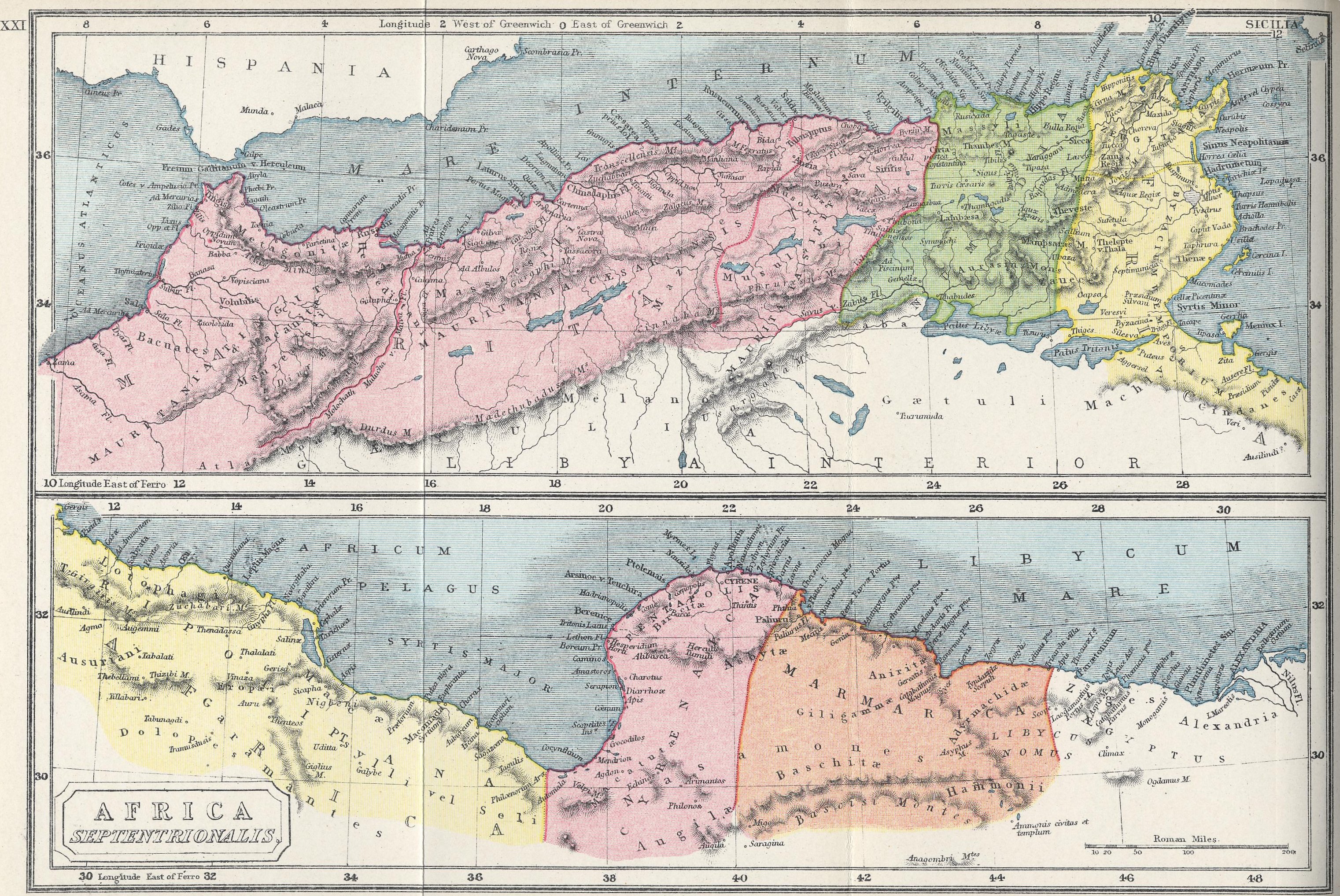
The African limes with the main military positions (in red) of the western provinces of Africa Proconsularis and the Mauretanias.
After the death of Ptolemy of Mauretania, son of Juba II, the emperor Caligula placed Mauretania under direct Roman control in 40. After suppressing a revolt of the local Berber tribes, Claudius in 42 created the two new provinces of Mauretania Caesariensis (with capital at Iol-Caesarea, today Cherchell) and Mauretania Tingitana (with capital first probably at Volubilis and later at Tingis, today Tangier). The defence of the two provinces was entrusted to auxiliary troops numbering several thousand. When interior tribes created serious military situations, detachments of the Legio III Augusta from neighbouring Numidia were sent, known as vexillationes.
From the time of Trajan, the borders of Africa Proconsularis expanded southwards and westwards, occupying territories formerly belonging to the Kings of Numidia, up to the highlands of the Aures Mountains.[47] Two fortified lines were established, one north and one south of the Aurès mountains, guarded by numerous forts and fortlets (in addition to the legionary fortress of Lambaesis) and integrated by a continuous Fossatum Africae with outposts extending into the desert.[48]
The final advance of this western sector of the limes occurred both in Numidia (southwards and westwards, combined with an advance of neighbouring Mauretania Caesariensis to the south) and in Tripolitania. In both cases this expansion was carried out by the African emperor Septimius Severus, native of Leptis Magna. His successors during the troubled period of the Crisis of the Third Century and later Diocletian added further fortified posts to the defensive system, bringing Roman expansion in the south to its greatest extent in the 3rd century.
The African frontier (dark brown) in the late 1st century AD. Septimius Severus greatly expanded the Limes Tripolitanus (lighter brown). There was also, briefly, a Roman military presence in the Garamantian capital Garama in 203.
As for the Limes Tripolitanus, it was the last section of the limes Africanus to be organized, again thanks to Septimius Severus, who brought the Roman Empire to its greatest expansion in North Africa and paid particular attention to this frontier sector.[49]
A similar development occurred in the Mauretanian frontier sector, also under Septimius Severus, when a further southward advance in Caesariensis was accompanied by the construction of a new military road with forts, fortlets and watchtowers. A zone thus formed between the two roads (that of Trajan and Hadrian, and this later one of Septimius Severus), called Nova Praetentura, where a form of defence in depth was implemented, whose territories served as a buffer zone for nomadic or semi-nomadic populations to the south.[50] This defensive system was very similar in function to that of Dacia Malvensis along the Limes Alutanus and Limes Transalutanus.
During the 3rd century the entire southern front was placed under constant pressure from African semi-nomadic populations, especially from the mid-century onward. The western sector, although protected to the south by the natural barrier of the Sahara, was forced to defend itself against the growing pressure of Berber peoples and was weakened by the continual usurpations of the period of military anarchy.
With the rise of Diocletian, the empire underwent a radical internal transformation, especially at the military level. Divided into four parts (two Augusti and two Caesares), it was further divided into 12 dioceses, each entrusted to a vicarius, subordinate to one of the four Praetorian prefects. The vicarius in turn supervised all the provincial governors (variously titled proconsules, consulares, correctores, praesides). The troops stationed in each diocese were placed under a comes rei militaris, dependent directly on the magister militum and commanding the duxes responsible for military command in individual provinces.[51] At the end of 297 the AugustusMaximian campaigned in Mauretania, defeating the tribe known as the Quinquegentiani, who had also penetrated Numidia. The following year (298) he reinforced the African frontier from the Mauretanias to Africa Proconsularis.[52]
Further changes were introduced under Constantine the Great and his successors down to Theodosius I, when the Roman Empire was definitively divided into pars Occidentalis and pars Orientalis (395), as confirmed by the Notitia Dignitatum (c. 400). This administrative-military structure remained largely unchanged until the invasion of the Vandals in 429, when barbarian forces poured into Mauretania and first captured Caesarea (modern Cherchell). From there they occupied Tunisia and Africa Proconsularis as far as Tripolitania. Their rule lasted throughout the 5th century until the Byzantine general Belisarius reconquered North Africa in 533.
Black lines indicating the approximate path of the 4 sections of the Fossatum Africae
Fossatum Africae ("African ditch") is a linear defensive structure (limes) that extended over 750km or more[53] in northern Africa constructed during the Roman Empire to defend and control the southern borders of the Empire in the Roman province of Africa. It is considered to have many similarities of construction to Hadrian's Wall at the northern border of the Empire in Britain. Generally the Fossatum consists of a ditch and earth embankments on either side using the material from the ditch. Sometimes the embankments are supplemented by dry stone walls on one or both sides; rarely, there are stone walls without a ditch. The width of the Fossatum is generally 3–6 m but in exceptional cases may be as much as 20 m. Wherever possible, it or its highest wall is constructed on the counterscarp. Excavations near Gemellae showed the depth there to be 2–3 m, with a width of 1 m at the bottom widening to 2–3 m at the top.[54]
The Fossatum is accompanied by many small watchtowers and numerous forts, often built within sight of one another.
The defence of the eastern African region mainly concerned the valley of the Nile (a narrow strip of fertile land within surrounding desert, crucial for the grain supply of Rome), the Mediterranean coasts from Egypt to Cyrenaica, certain landing points on the Red Sea (such as Berenice Troglodytica), important for trade with the Far East (from which spices and luxury goods were imported) and with the Kingdom of Aksum, and finally the mountainous area of the Eastern Desert, rich in mines of gold, emeralds, granite and porphyry.[55]
In 96 BC Ptolemy Apion of the Ptolemaic dynasty became the last Hellenistic ruler of Cyrenaica. At his death he bequeathed his kingdom to the Roman Republic. The new territories were organized into a Roman province only in 74 BC with the arrival of the first legatus pro praetore, assisted by a quaestor. It consisted of five cities of Greek origin forming the so-called Cyrenaican Pentapolis.
These events were followed by numerous pacification campaigns along the eastern African frontier, through which many populations were fought and incorporated into the Roman Empire between 29 BC and AD 1, as also recorded in the Fasti triumphales.[46]
The greatest problems encountered in the region concerned religious conflicts between Greeks and Jews, particularly at Alexandria, which after the destruction of Jerusalem in 70 became a major centre of Jewish religion and culture. Under Trajan a second Jewish revolt broke out, culminating in the repression of the Jews of Alexandria.
In the time of Domitian (around 85–86), the tributary people of the Nasamones (living south of the African coast between Cyrenaica and Leptis Magna) rebelled, but were soon annihilated, so that Domitian reportedly declared before the Senate: "I have forbidden the Nasamones to exist."[56]
There was later a gradual reduction in the number of legions stationed in the area (from three to only one), which should not be misleading: the decrease in legionary forces corresponded to an increase in auxiliary forces. While there were few external dangers, the internal situation instead saw a progressive increase in social tensions, from banditry in the countryside to open revolts, such as the Jewish uprising of 115–117 or the revolt of the Bucoli in 172,[57] during the reign of Marcus Aurelius, caused by excessive taxation.
Further adjustments were made under Constantine the Great and his successors down to Theodosius I, when the empire was definitively divided into pars Occidentalis and pars Orientalis (395), as confirmed by the Notitia Dignitatum. The region remained part of the Byzantine Empire until the Arab conquest of the 7th century.
Post-Roman limites
The Limes Saxoniae in Holstein was established in 810AD, long after the fall of the Western Roman Empire. Charlemagne considered his empire (later called the Carolingian Empire) as the true successor to the Roman Empire and called himself "Emperor of the Romans". Official edicts were issued in Latin, which affected the naming of the Empire's frontier as well.
In fiction
The novel series Romanike is set at the Limes Germanicus in the decades until the first assault of Germanic peoples in 161AD.[59]
Roman Wall: A Novel, by Winifred Bryher is set in 265 during the Limesfall.[60]
Gallery
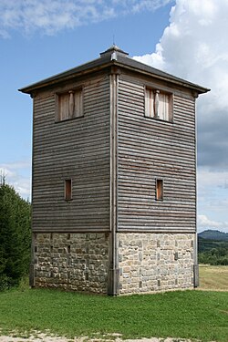
Reconstructed east gate of the fort at Welzheim, Germany
↑Benjamin Isaac, "The Meaning of 'Limes' and 'Limitanei' in Ancient Sources", Journal of Roman Studies, 78 (1988), pp.125–147
↑Benjamin Isaac, "The Meaning of 'Limes' and 'Limitanei' in Ancient Sources", Journal of Roman Studies, 78 (1988), pp.125–147; Benjamin Isaac, The Limits of Empire: the Roman Army in the East (Oxford: Oxford University Press, revised edition 1992).
↑W. Gebert, "Limes", Untersuchungen zur Erklärung des Vortes und seiner Anwendung, Bonner Jahrbücher Bd. 119, No. 2, 1910, 158–205.
↑Carol-Opriş, Ioan; Raţiu, Alexandru; Stoian, Gabriel, Stadiul cercetării siturilor din jud. Braşov şi Covasna ("Stage of the research in Braşov and Covasna Counties"), Raport ştiinţific Privind Derularea Proiectului Strategii Defensive şi Politici Transfrontaliere: Integrarea Spaţiului Dunării De Jos în Civilizaţia Romană (STRATEG) ("Scientific Report on the Progress of the Project "Defensive Strategies and Border Policies: Integration of the Lower Danube Region in Roman Civilization (STRATEG)""), pp. 37–
↑Tacitus, De vita et moribus Julius Agricolae, 41, 2–3
↑E. Schallmayer, Der Limes. Geschichte einer Grenze, München, 2006, p. 14
↑Scriptores Historiae Augustae, De vita Hadriani, XII, 6
↑Hessian state archaeologist Prof. E. Schallmeyer, quoted in Schmid, A., Schmid, R., Möhn, A., Die Römer an Rhein und Main (Frankfurt: Societäts-Verlag, revised edition 2006).
12Yann Le Bohec, L'esercito romano da Augusto alla fine del III secolo, Rome 1992, 7th reprint 2008, p. 206.
↑M.J.T. Lewis: Surveying Instruments of Greece and Rome, Cambridge University Press, 2001, ISBN0-521-79297-5, pp.242 245.
↑This figure depends very much on the way it is measured over the intervals where the Fossatum was not constructed or has disappeared, and includes a significant section which may not be a fossatum.
AAVV, The world of imperial Rome: its formation, Bari 1989.
Geraci, Giovanni; Marcone, Arnaldo (2004). Storia romana[Roman history]. Florence: Le Monnier. ISBN88-00-86082-6.
M. Grant, The Roman emperors, Rome 1984.
E. Luttwak, The grand strategy of the Roman Empire, Milan 1981.
H. M. D. Parker, The Roman Legions, Cambridge 1958.
S. Rinaldi Tufi, Archaeology of the Roman provinces, Rome 2007.
C. Scarre, The Penguin historical atlas of ancient Rome, 1995. ISBN 0-14-051329-9
J. S. Wacher, The Roman world, New York 2002, ISBN 0-415-26314-X
Limes Congress
1st International Congress of Roman Frontier Studies, edited by E. Birley, Durham 1952;
2nd International Congress of Roman Frontier Studies, edited by E. Swoboda, Graz-Cologne 1956;
3rd International Congress of Roman Frontier Studies, edited by R. Laur-Belart, Basel 1959;
4th International Congress of Roman Frontier Studies, Durham 1959;
5th International Congress of Roman Frontier Studies, edited by Grga Novak, Zagreb 1964;
6th International Congress of Roman Frontier Studies, edited by H. Schonberger, Cologne-Graz 1967;
7th International Congress of Roman Frontier Studies, edited by S. Appelbaum, Tel Aviv 1971;
8th International Congress of Roman Frontier Studies, edited by E. Birley, B. Dobson and M. Jarrett, Cardiff 1974;
9th International Congress of Roman Frontier Studies, edited by D. M. Pippidi, Bucharest 1974;
10th International Congress of Roman Frontier Studies, edited by D. Haupt and H. G. Horn, Cologne 1974;
11th International Congress of Roman Frontier Studies, edited by J. Fitz, Budapest 1977;
12th International Congress of Roman Frontier Studies, edited by W. S. Hanson and L. J. F. Keppie, Oxford 1980;
13th International Congress of Roman Frontier Studies, edited by C. Unz, Stuttgart 1986;
14th International Congress of Roman Frontier Studies, edited by H. Vetters and M. Kandler, Vienna 1990;
15th International Congress of Roman Frontier Studies, edited by V. A. Maxfield and M. J. Dobson, Exeter 1991;
16th International Congress of Roman Frontier Studies, edited by W. Groenman-van Waateringe, B. L. van Beek, W. J. H. Willems and S. L. Wynia, Exeter 1997;
17th International Congress of Roman Frontier Studies, edited by N. Gudea, Zalau 1999;
18th International Congress of Roman Frontier Studies, edited by P. Freeman, J. Bennett, Z. T. Fiema and B. Hoffmann, Oxford 2002;
19th International Congress of Roman Frontier Studies, edited by Z. Visy, Pecs 2003;
20th International Congress of Roman Frontier Studies, edited by Angel Morillo Cerdan, Leon 2006.
This page is based on this Wikipedia article Text is available under the CC BY-SA 4.0 license; additional terms may apply. Images, videos and audio are available under their respective licenses.


