Mauretania Tingitana

Last updated
Provincia Mauretania Tingitana
Province of the Roman Empire
42 AD–Late 7th century
Roman Empire - Mauretania Tingitana (125 AD).svg
The province of Mauretania Tingitana within the Roman Empire, c.125 AD
Capital Tingis, Septem
History
Historical era Classical Antiquity, Late Antiquity
 Incorporated into the Roman Empire as a full province
42 AD
 Vandal Conquest
430s AD
 Byzantine partial reconquest by Vandalic War
534 AD
Late 7th century
Preceded by
Succeeded by
Mauretania et Numidia.jpg Mauretania
Vandales.png Vandal Kingdom
Vandal Kingdom Vandales.png
Umayyad Caliphate Umayyad750ADloc.png
Today part of Morocco
Spain:
Ceuta
Melilla
Plazas de soberanía
Roman territories in the Maghreb, showing that the southern limits of Mauretania Tingitana reached Casablanca Mauretania et Numidia.jpg
Roman territories in the Maghreb, showing that the southern limits of Mauretania Tingitana reached Casablanca

Mauretania Tingitana (Latin for "Tangerine Mauretania") was a Roman province, coinciding roughly with the northern part of present-day Morocco. [1] The territory stretched from the northern peninsula opposite Gibraltar, to Sala Colonia (or Chellah) and Volubilis to the south, [2] and as far east as the Mulucha (or Malva) river. Its capital city was Tingis, which is the modern Tangier. Other major cities of the province were Iulia Valentia Banasa, Septem, Rusadir, Lixus and Tamuda. [3]

Contents

History

Sebastian Munster's Aphricae Tabula I, depicting Mauretania Tingitana in 1540 Munster Aphricae Tabula I 1540 UTA.jpg
Sebastian Münster's Aphricae Tabula I, depicting Mauretania Tingitana in 1540

After the death in 40 AD of Ptolemy of Mauretania, the last Ptolemaic ruler of the Kingdom of Mauretania, in about 44 AD Roman Emperor Claudius annexed the kingdom to the Roman Empire and partitioned it into two Roman provinces: Mauretania Tingitana and Mauretania Caesariensis. [1] The Mulucha (Moulouya River), located around 60 km west of modern Oran, Algeria, became the border separating them. [1] [4]

The Roman occupation did not extend very far into the continent. In the far west, the southern limit of imperial rule was Volubilis, which was ringed with military camps such as Tocolosida slightly to the south east and Ain Chkour to the north-west, and a fossatum or defensive ditch. On the Atlantic coast Sala Colonia was protected by another ditch and a rampart and a line of watchtowers.

This was not a continuous line of fortifications: there is no evidence of a defensive wall like the one that protected the turbulent frontier in Britain at the other extremity of the Roman Empire. Rather, it was a network of forts and ditches that seems to have functioned as a filter. The limes – the word from which the English word “limit” is derived – protected the areas that were under direct Roman control by funnelling contacts with the interior through the major settlements, regulating the links between the nomads and transhumants with the towns and farms of the occupied areas.

The same people lived on both sides of these limes, although the population was quite small. Volubilis had perhaps twenty thousand inhabitants at most in the second century. On the evidence of inscriptions, only around ten to twenty per cent of them were of European origin, mainly Spanish; the rest were local.

Roman historians (like Ptolemy) considered all of Morocco north of the Atlas Mountains part of the Roman Empire, because in the times of Augustus, Mauretania was a vassal state and its rulers (like Juba II) controlled all the areas south of Volubilis. The effective control of Roman legionaries, however, was up to the area of Sala Colonia (the castra "Exploratio Ad Mercurios", south of Sala Colonia, is the southernmost Roman settlement discovered until now). Some historians, like Leo Africanus, believe the Roman frontier reached the area of Casablanca, founded by the Romans as a port named "Anfa". Indeed, the modern city of Azemmour in central Morocco lies on the ancient Azama, a trading port of Phoenician and later Roman origins. Still today can be seen the remains of a Roman deposit for grain in the so-called "Portuguese cisterns". [5]

Pliny the Elder described in some detail the area south of the Atlas Mountains, when Gaius Suetonius Paulinus undertook a military expedition in 41:

Suetonius Paulinus, whom we have seen Consul in our own time, was the first Roman general who advanced a distance of some miles beyond Mount Atlas. He has given us the same information as we have received from other sources with reference to the extraordinary height of this mountain, and at the same time he has stated that all the lower parts about the foot of it are covered with dense and lofty forests composed of trees of species hitherto unknown. The height of these trees, he says, is remarkable; the trunks are without knots, and of a smooth and glossy surface; the foliage is like that of the cypress, and besides sending forth a powerful odour, they are covered with a flossy down, from which, by the aid of art, a fine cloth might easily be manufactured, similar to the textures made from the produce of the silk-worm. He informs us that the summit of this mountain is covered with snow even in summer, and says that having arrived there after a march of ten days, he proceeded some distance beyond it as far as a river which bears the name of Ger (a northern affluent of the Niger river?); the road being through deserts covered with a black sand, from which rocks that bore the appearance of having been exposed to the action of fire, projected every here and there; localities rendered quite uninhabitable by the intensity of the heat, as he himself experienced, although it was in the winter season that he visited them. [6]

Roman province

During the reign of the Numidian King Juba II, Emperor Augustus had already founded three colonias (with Roman citizens) in Mauretania close to the Atlantic coast: Iulia Constantia Zilil, Iulia Valentia Banasa and Iulia Campestris Babba.

This western part of Mauretania was to become the province called Mauretania Tingitana shortly afterwards. The region remained a part of the Roman Empire until 429, when the Vandals overran the area and Roman administrative presence came to an end.

The Roman empire in the time of Hadrian (ruled 117-138 AD), showing, in northwestern Africa, the imperial province of Mauretania Tingitana (Morocco) Roman Empire 125.png
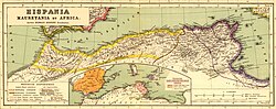
The Roman empire in the time of Hadrian (ruled 117–138 AD), showing, in northwestern Africa, the imperial province of Mauretania Tingitana (Morocco)

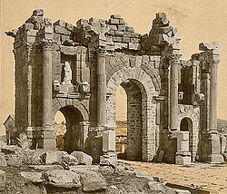
The most important city of Mauretania Tingitana was Volubilis. This city was the administrative and economic center of the province in western Roman Africa. The fertile lands of the province produced many commodities such as grain and olive oil, which were exported to Rome, contributing to the province's wealth and prosperity. Archaeology has documented the presence of a Jewish community in the Roman period. [7]

The principal exports from Mauretania Tingitana were purple dyes and valuable timber. Tingitana also supplied Rome with agricultural goods and animals, such as lions and leopards. The native Mauri were highly regarded and recruited by the Romans as soldiers, especially as light cavalry. Clementius Valerius Marcellinus is recorded as the governor (praeses) between 24 October 277 and 13 April 280. [8]

According to tradition, the martyrdom of St Marcellus took place on 28 July 298 at Tingis (Tangier). During the Tetrarchy (Emperor Diocletian's reform of Roman governmental structures in 297), Mauretania Tingitana became part of the Diocese of Hispaniae, 'the Spains', and, by extension, part of the Praetorian prefecture of Gaul, thus it was across the sea from the European territory of Diocese and Prefecture it belonged to. Mauretania Caesariensis was in the Diocese of Africa. Lucilius Constantius is recorded as governor (praeses) in the late fourth century.

The Notitia Dignitatum shows also, in its military organisation, a Comes Tingitaniae with a field army composed of two legions, three vexillations, and two auxilia palatina. Flavius Memorius held this office (comes) at some point during the middle of the fourth century. However, it is implicit in the source material that there was a single military command for both of the Mauretanian provinces, with a Dux Mauretaniae (a lower rank) controlling seven cohorts and one ala.

The Germanic Vandals established themselves in the province of Baetica in 422 AD under their king, Gunderic, and, from there, they carried out raids on Mauretania Tingitana. In 427 AD, the Comes Africae , Bonifacius, rejected an order of recall from the Emperor Valentinian III, and he defeated an army sent against him. He was less fortunate when a second force was sent in 428 AD. In that year, Gunderic was succeeded by Gaiseric, and Bonifacius invited Gaiseric into Africa, providing a fleet to enable the passage of the Vandals to Tingis and Septem (Ceuta). Bonifacius intended to confine the Vandals to Mauretania, but, once they had crossed the straits, they rejected any control and marched on Carthage.

Byzantines

In 533 AD, the Byzantine general Belisarius reconquered the former Diocese of Africa from the Vandals on behalf of the Emperor Justinian I. All the territory west of Caesarea had already been lost by the Vandals to the Berber "Mauri", but a re-established Dux Mauretaniae kept a military unit at Septem (modern Ceuta). This was the last Byzantine outpost in Mauretania Tingitana; the rest of what had been the Roman province was united with the Byzantine part of Andalusia under the name of the Praetorian prefecture of Africa, with Septem as administrative capital.

Most of the Maghreb littoral was later organised as the Exarchate of Africa, a special status in view of the outpost defense needs.

When the Umayyad Caliphate conquered all of Northern Africa, it brought Islam to the local adherents of the traditional Berber religion and Christianity. The two Mauretania provinces were consolidated as the territory of al-Maghrib (Arabic for 'the West', and still the official name of the Sharifian Kingdom of Morocco). This larger province also included over half of modern Algeria.

Stone ruins dating from the Roman era exist at various archaeological sites, including the Capitoline Temple at Volubilis, the palace of Gordius, Sala Colonia, Tingis and Iulia Constantia Zilil.

See also

Related Research Articles

<span class="mw-page-title-main">Mauretania</span> Region in the ancient Maghreb

Mauretania is the Latin name for a region in the ancient Maghreb. It stretched from central present-day Algeria westwards to the Atlantic, covering northern present-day Morocco, and southward to the Atlas Mountains. Its native inhabitants, of Berber ancestry, were known to the Romans as the Mauri and the Masaesyli.

<span class="mw-page-title-main">Mauretania Caesariensis</span> Roman province in northwest Africa

Mauretania Caesariensis was a Roman province located in what is now Algeria in the Maghreb. The full name refers to its capital Caesarea Mauretaniae.

<span class="mw-page-title-main">Tingi</span>

Tingis or Tingi, the ancient name of Tangier in Morocco, was an important Carthaginian, Moor, and Roman port on the Atlantic Ocean. It was eventually granted the status of a Roman colony and made the capital of the province of Mauretania Tingitana and, after Diocletian's reforms, the diocese of Hispania.

<span class="mw-page-title-main">Chellah</span> Medieval Muslim necropolis near Rabat, Morocco

The Chellah or Shalla, is a medieval fortified Muslim necropolis and ancient archeological site in Rabat, Morocco, located on the south (left) side of the Bou Regreg estuary. The earliest evidence of the site's occupation suggests that the Phoenicians established a trading emporium here in the first millennium BC. This was later the site of Sala Colonia, an ancient Roman colony in the province of Mauretania Tingitana, before it was abandoned in Late Antiquity. In the late 13th century the site began to be used as a dynastic necropolis for the Marinid dynasty. By the mid-14th century Marinid sultans had enclosed a part of the site with a new set of walls and built a religious complex inside it to accompany their mausoleums. In the 15th century the necropolis began to decline and it suffered damage over the centuries due to earthquakes and looting. Archeological excavations in the 20th century unearthed the remains of the ancient Roman town. Today the site is a tourist attraction and since 2012 it forms part of a UNESCO World Heritage Site.

Anfa was the ancient toponym for Casablanca during the classical period. The city was founded by Berbers around the 10th century BC, with the Romans under Augustus later establishing the commercial port of "Anfus" in 15 BC. Anfa is now the name of a district in the oldest part of Casablanca, located in the Casablanca-Settat region of Morocco. The district covers an area of 37.5 square kilometres, and as of 2004 had 492,787 inhabitants.

<span class="mw-page-title-main">Tamuda</span> Ancient Berber city and Roman military camp in Morocco

Tamuda was an ancient Berber city and military camp in Mauretania Tingitana. It is located 6 km west of the present-day Tetouan in northern Morocco. Stone ruins from the site are found by the south bank of the Martil Valley. It was considered a city in accordance with the rules of urbanization of the time.

<span class="mw-page-title-main">Mauretania Sitifensis</span>

Mauretania Sitifensis was a Roman province in Northwest Africa. The capital was Setifis.

<span class="mw-page-title-main">Abyla</span> Roman colony in northwest Africa

Abyla was the pre-Roman name of Ad Septem Fratres. Ad Septem Fratres, usually shortened to Septem or Septa, was a Roman colony in the province of Mauretania Tingitana and a Byzantine outpost in the exarchate of Africa. Its ruins are located within present-day Ceuta, an autonomous Spanish city in northwest Africa.

<span class="mw-page-title-main">Iulia Constantia Zilil</span>

Iulia Constantia Zilil was an ancient Roman-Berber city in Dchar Jdid, located 40 km southwest of Tangier and 13 km northeast of Asilah. It was one of the three colonias in Mauretania Tingitana founded by emperor Augustus between 33 and 25 BC for veterans of the battle of Actium.

<span class="mw-page-title-main">Iulia Valentia Banasa</span> Ancient Berber-Roman city in Morocco

Iulia Valentia Banasa was a Roman-Berber city in northern Morocco. It was one of the three colonias in Mauretania Tingitana founded by emperor Augustus between 33 and 25 BC for veterans of the battle of Actium, on top of a Mauretanian village. The site was in fact already occupied by the local Amazigh people from the 4th century BC, or perhaps earlier.

<span class="mw-page-title-main">Roman roads in Morocco</span>

Roman roads in Morocco were the western roads of Roman Africa.

<span class="mw-page-title-main">Thamusida</span> Berber, Carthaginian, and Roman river port near [[Kenitra]], [[Morocco]]

Thamusida was a Berber, Carthaginian, and Roman river port that was near the present-day towns of Kénitra and Mehdya in Morocco. Under the Roman Empire, it formed a part of the province of Mauretania Tingitana.

<span class="mw-page-title-main">Altava</span>

Altava was an ancient Romano-Berber city in present-day Algeria. It served as the capital of the ancient Berber Kingdom of Altava. During the French presence, the town was called Lamoriciere. It was situated in the modern Ouled Mimoun near Tlemcen.

<span class="mw-page-title-main">Caesarea in Mauretania</span> Ancient city and bishopric in Roman North Africa

Caesarea in Mauretania was a Roman colony in Roman-Berber North Africa. It was the capital of Mauretania Caesariensis and is now called Cherchell, in modern Algeria. In the present time Caesarea is used as a titular see for Catholic and Eastern Orthodox bishops.

<span class="mw-page-title-main">Iulia Campestris Babba</span>

Iulia Campestris Babba is a Mauretanian city created as Roman colony around 30 BC by emperor Augustus. Its actual location is currently unknown, though its existence is confirmed by the literature.

<span class="mw-page-title-main">Kingdom of Altava</span>

The Kingdom of Altava was an independent Christian Berber kingdom centered on the city of Altava in present-day northern Algeria. The Kingdom of Altava was a successor state of the previous Mauro-Roman Kingdom which had controlled much of the ancient Roman province of Mauretania Caesariensis. During the reign of Kusaila, it extended from Volubilis in the west to the Aurès and later Kairaouan and the interior of Ifriqiya in the east. This Kingdom collapsed following Eastern Roman military campaigns to decrease its influence and power after Garmul invaded the Exarchate of Africa.

<span class="mw-page-title-main">Roman colonies in Berber Africa</span>

Roman colonies in Berber Africa are the cities—populated by Roman citizens—created in North Africa by the Roman Empire, mainly in the period between the reigns of Augustus and Trajan.

<i>Limes Mauretaniae</i>

The Limes Mauretaniae was a portion of a 4,000-kilometre (2,500 mi) Roman fortified border (limes) in Africa approximately 100 kilometres (62 mi) south of the modern day Algiers.

<span class="mw-page-title-main">Mauro-Roman Kingdom</span> Early medieval Christian Romano-Berber state

The Mauro-Roman Kingdom was an independent Christian Berber kingdom centred in the capital city of Altava which controlled much of the ancient Roman province of Mauretania Caesariensis. The kingdom was first formed in the fifth century as Roman control over the province weakened and Imperial resources had to be concentrated elsewhere, notably in defending the Italian Peninsula itself from invading Germanic tribes.

<span class="mw-page-title-main">Vandal conquest of Roman Africa</span>

The Vandal conquest of Roman Africa, also known as the Vandal conquest of North Africa, was the conquest of Mauretania Tingitana, Mauretania Caesariensis, and Africa Proconsolaris by the migrating Vandals and Alans. The conflict lasted 13 years with a period of four years of peace, and led to the establishment of the Vandal Kingdom in 435.

References

  1. 1 2 3 Chisholm, Hugh, ed. (1911). "Mauretania"  . Encyclopædia Britannica . Vol. 17 (11th ed.). Cambridge University Press. p. 908.
  2. C. Michael Hogan, Chellah, The Megalithic Portal, ed. Andy Burnham
  3. University of Granada: Mauretania Tingitana (in Spanish)
  4. Richard J.A. Talberts, Barrington Atlas of the Greek and Roman World - p. 457
  5. Roman Azama
  6. Pliny the Elder, Natural History 5.1
  7. Two Thousand Years of Jewish Life in Morocco, Haim Zafrani, Ktav, 2005, p. 2
  8. J.E.H. Spaul, "Governors of Tingitana", Antiquités africaines 30 (1994), p. 253

Further reading