
Gallia Lugdunensis was a province of the Roman Empire in what is now the modern country of France, part of the Celtic territory of Gaul formerly known as Celtica. It is named after its capital Lugdunum, possibly Roman Europe's major city west of Italy, and a major imperial mint. Outside Lugdunum was the Sanctuary of the Three Gauls, where representatives met to celebrate the cult of Rome and Augustus.

Noricum is the Latin name for the kingdom or federation of tribes that included most of modern Austria and part of Slovenia. In the first century AD, it became a province of the Roman Empire. Its borders were the Danube to the north, Raetia and Vindelici to the west, Pannonia to the east and south-east, and Italia to the south. The kingdom was founded around 400 BC, and had its capital at the royal residence at Virunum on the Magdalensberg.

Raetia or Rhaetia was a province of the Roman Empire named after the Rhaetian people. It bordered on the west with the country of the Helvetii, on the east with Noricum, on the north with Vindelicia, on the south-west with Transalpine Gaul and on the south with Venetia et Histria, a region of Roman Italy.

Alamannia, or Alemania, was the kingdom established and inhabited by the Alemanni, a Germanic tribal confederation that had broken through the Roman limes in 213.
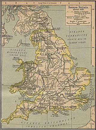
Britannia Prima or Britannia I was one of the provinces of the Diocese of "the Britains" created during the Diocletian Reforms at the end of the 3rd century. It was probably created after the defeat of the usurper Allectus by Constantius Chlorus in AD 296 and was mentioned in the c. 312 Verona List of the Roman provinces. Its position and capital remain uncertain, although it was probably located closer to Rome than Britannia II. At present, most scholars place Britannia I in Wales, Cornwall, and the lands connecting them. On the basis of a recovered inscription, its capital is now usually placed at Corinium of the Dobunni (Cirencester) but some emendations of the list of bishops attending the 315 Council of Arles would place a provincial capital in Isca (Caerleon) or Deva (Chester), which were known legionary bases.
Britannia Secunda or Britannia II was one of the provinces of the Diocese of "the Britains" created during the Diocletian Reforms at the end of the 3rd century. It was probably created after the defeat of the usurper Allectus by Constantius Chlorus in AD 296 and was mentioned in the c. 312 Verona List of the Roman provinces. Its position and capital remain uncertain, although it probably lay further from Rome than Britannia I. At present, most scholars place Britannia II in Yorkshire and northern England. If so, its capital would have been Eboracum (York).
Maxima Caesariensis, also known as Britannia Maxima, was one of the provinces of the Diocese of "the Britains" created during the Diocletian Reforms at the end of the 3rd century. It was probably created after the defeat of the usurper Allectus by Constantius Chlorus in AD 296 and was mentioned in the c. 312 Verona List of the Roman provinces. Its position and capital remain uncertain, although it was probably adjacent to Flavia Caesariensis. On the basis of its governor's eventual consular rank, it is now usually considered to have consisted of Augusta or Londinium (London) and southeastern England.

Italia, also referred to as Roman Italy, was the homeland of the ancient Romans. According to Roman mythology, Italy was the ancestral home promised by Jupiter to Aeneas of Troy and his descendants, Romulus and Remus, who were the founders of Rome. Aside from the legendary accounts, Rome was an Italic city-state that changed its form of government from Kingdom to Republic and then grew within the context of a peninsula dominated by the Gauls, Ligures, Veneti, Camunni and Histri in the North, the Etruscans, Latins, Falisci, Picentes and Umbri tribes in the Centre, and the Iapygian tribes, the Oscan tribes, and Greek colonies in the South.

The Alpes Graiae et Poeninae, later known as Alpes Atrectianae et Poeninae, was a small Alpine province of the Roman Empire created after the merging of the Alpes Poeninae and the Alpes Graiae, probably during the reign of Claudius. Comprising the modern Canton of Valais (Switzerland), the Tarantaise Valley (France), and the Aosta Valley (Italy), it was one of the three provinces straddling the Alps between modern France and Italy, along with the Alpes Maritimae and Alpes Cottiae.

The Three Leagues, sometimes referred to as Raetia, was the 1471 alliance between the League of God's House, the League of the Ten Jurisdictions, and the Grey League. Its members were all associates of the Old Swiss Confederacy, and as such enjoyed positive relations with the Confederation, which eventually led to the formation of the Swiss canton of Grisons.
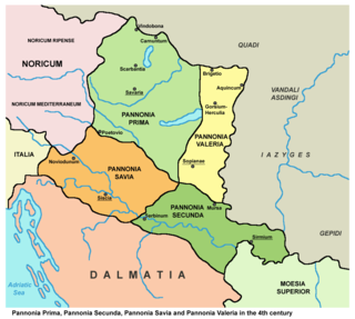
Pannonia Prima was an ancient Roman province. It was formed in the year 296, during the reign of Emperor Diocletian. Previously, it was a part of the province of Pannonia Superior, which, along with Pannonia Inferior, was gradually divided into four administrative units: Pannonia Prima, Pannonia Secunda, Valeria, and Savia. This transition was completed by the time of Constantine. According to the Notitia Dignitatum, Pannonia Prima was governed by a Praeses.

Dacia Ripensis was the name of a Roman province in the northern Balkan peninsula, immediately south of the Middle Danube. Its capital was Ratiaria. It was a district less urban than neighbouring Dacia Mediterranea and more militarized; "military camps and forts, rather than cities, were typical of the province". Besides Ratiaria, Oescus was the major settlement.
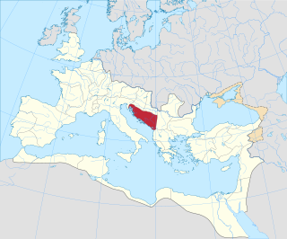
Dalmatia was a Roman province. Its name is derived from the name of an Illyrian tribe called the Dalmatae, which lived in the central area of the eastern coast of the Adriatic Sea. It encompassed the northern part of present-day Albania, much of Croatia, Bosnia and Herzegovina, Montenegro,and Serbia, thus covering an area significantly larger than the current Croatian and Montenegrin region of Dalmatia. Originally this region was called Illyria or Illyricum.

The Romansh people are a Romance ethnic group, the speakers of the Romansh language, native to the Swiss canton of Grisons (Graubünden).

The territory of modern Switzerland was a part of the Roman Republic and Empire for a period of about six centuries, beginning with the step-by-step conquest of the area by Roman armies from the 2nd century BC and ending with the Fall of the Western Roman Empire in the 5th century AD.
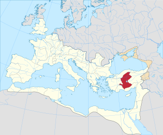
Galatia was the name of a province of the Roman Empire in Anatolia. It was established by the first emperor, Augustus, in 25 BC, covering most of formerly independent Celtic Galatia, with its capital at Ancyra.

Cilicia was an early Roman province, located on what is today the southern (Mediterranean) coast of Turkey. Cilicia was annexed to the Roman Republic in 64 BC by Pompey, as a consequence of his victory over the Cilician pirates and in the Third Mithridatic War. It was subdivided by Diocletian in around 297, and it remained under Roman rule for several centuries, until falling to the Islamic conquests.

Raetia Curiensis was an early medieval province in Central Europe, named after the preceding Roman province of Raetia prima which retained its Romansh culture during the Migration Period, while the adjacent territories in the north were largely settled by Alemannic tribes. The administrative capital was Chur in the present Swiss canton of Grisons.

The Danube–Iller–Rhine Limes or DIRL was a large-scale defensive system of the Roman Empire that was built after the project for the Upper Germanic-Rhaetian Limes in the late 3rd century AD. In a narrower sense the term refers only to the fortifications between Lake Constance and the River Danube (Danubius); in a broader sense it also includes the other Late Roman fortifications along the river Rhine (Rhenus) on the High Rhine and on the Upper Rhine as well as the Upper Danube.
