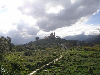
Auzia probably took the name from the Berber pagan god "Auzius", because under Augustus a Roman castrum was founded near a small Berber village with that name [1] The city constituted of a castrum (fort) and a vicus (small city): Auzia achieved autonomous status as municipium in the second century and later was renamed Colonia Septima Aurelia Auziense by emperor Septimius Severus. As a Roman colonia, its people received full status of Roman citizenship rights.
Tacitus wrote about a "Castellum Auziense", as the headquarters of the Roman garrison commander in Mauretania Caesariensis's central limes (border fortifications).
According to the historian Richard Lawless, Auzia was a vicus that achieved independent status from the castrum (fort) garrison and had a forum (market square) and an important pagan temple, later converted into a Christian church.[2] The Roman settlement (probably with nearly 4,000 inhabitants around 200 AD) was surrounded by farms.[2]
Auzia had even a theater and a small "circus" for chariot races, created around 227 AD according to epigraphic evidence[3]
Auzia achieved prosperity mainly because it was at the center of some roads in Roman Africa: from Auzia there were roads toward the Mediterranean sea (Caesarea) and the Saharan interior with the Atlas mountains.[4]
In 290 AD, however, the Bavares tribe attacked Auzia and the city suffered huge destruction. Vandals and Byzantine troops occupied temporarily the city.
It was reduced to a small village when Arabs conquered the region at the end of the seventh century.
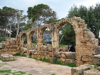
Archaeology
According to the sources, the French had undertaken several excavations in the ruins of Auzia without ever revealing the slightest historical fact to scientific research because of the policy of francization which was aimed at erasing all trace of civilization old or present on the territory Algerian.[citation needed]
In addition, the reconstruction of Auzia would have destroyed several historical sites in the time of the Duke of Aumale. All the large-scale excavations were carried out secretly by the French authorities, who forbade access to the sites to the Arabs, which means that they wanted to hide all the increasingly numerous A civilization fundamentally different from that of the Roman Empire. The French administrative decision prompts the workers with a confidential note to destroy all objects and funeral inscriptions found in the site of the temple of Apollo, completely destroyed to build the civil hospital there - a truth conveyed through history by Algerians who participated in the construction of the city of Aumale. At the same time, Auzia was not occupied by inhabitants, it was about Roman ruins that the French choose for the construction of the city of Aumale. The inhabitants of the region, mostly from the tribes of Ouled Driss, Ouled Faârha and Ouled Khalouf who occupied the Dirah Mountains, organized themselves and succeeded in uniting all the tribes to oppose the French troops and then to be forced into negotiations.[citation needed]
Urban design
The study of the urbanism of the ruins reveals that the town of Auzia was fenced by a long wall of quarry stone, supposedly removed from the quarry located as the departmental road connecting Sour-El-Ghozlane - Ain-Bessem. A wall 75cm wide and 6.7km long surrounding the city. The total area of Auzia is 920 hectares. Inside, the Romans built a large military barracks at the entrance of Bab-El-Gurt (currently). There were several cohorts, commanded by a tribune militum, a squadron of Moorish vexillaries (light and mobile troops recruited from the provinces), supported in force by a cavalry corps (led by three decurions and a Præfectus equitum. Which was important for the Roman Empire and had a regional military district in charge of surveillance and intervention at the scale of the Tirinadi (Berrouaghia) region in the Djurdjura and Biban Mountains. (Djouab), the second in Afoul (Chalalat el-Adhoura) and the third in the mountains of Jebel Lakhdar in Achir (The ruins located 4km from Ain-Boucif reveal the existence of this bastion advanced).[citation needed]
Population
The total area of Roman construction in the city of Auzia, a space of more than 720 hectares, reveals that the city was populated by a population of more than 12 000 to 13 000 inhabitants, that it would be the largest Roman city of Central Algeria, more important than Tipaza. But this figure could be increased in view of its status as a large military barracks. In addition, the shape of the city reveals a common principle of construction rules, based on the keys of modern urbanism namely the four functions: habitat, work, leisure and circulation. This quality of modern city that can be made of Auzia, attracted the inhabitants of all the tribes, which had resulted in a galloping demography which prompted the Roman authorities to found another city in the region, first to defend Auzia Repeated attacks by the Moors in a protected place, like a fortified enclosure. This was the origin of the foundation of CASTELLUM AUZIENS.[citation needed]
Former and Titular bishopric
Christianity was present in the Auzia area during the third century. It achieved the status of episcopal see. It was one of the many suffragans of the metropolitan Archbishopric of Mauretania Caesariensis, the capital of the Late Roman province of Mauretania Caesariensis, and faded like most.[citation needed]
The ancient diocese of Auzia was nominally revived in 1594 as a Latin Catholic titular bishopric of the lowest (episcopal) rank. It had many incumbents - all episcopal - until its suppression in 1913.
Hippo Regius is the ancient name of the modern city of Annaba, Algeria. It served as an important city for the Phoenicians, Berbers, Romans, and Vandals. Hippo was the capital city of the Vandal Kingdom from AD 435 to 439. when it was shifted to Carthage following the Vandal capture of Carthage in 439.
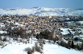
Médéa is the capital city of Médéa Province, Algeria. It is located roughly 68 km south of Algiers. The present-day city is situated on the site of an ancient Roman military post and has a history dating back to the 10th century. The town is French in character, with a rectangular city plan, red tile-roofed buildings, and beautiful public gardens. The hills surrounding Médéa are covered with vineyards, orchards, and farms that yield abundant grain. Médéa's chief products are wines, irrigation equipment, and various handicrafts.
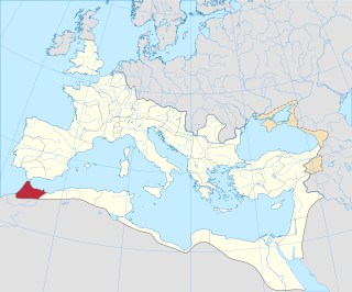
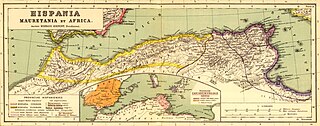
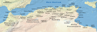
Mauretania Caesariensis was a Roman province located in present-day Algeria. The full name refers to its capital Caesarea Mauretaniae.
Mauretania Tingitana was a Roman province, coinciding roughly with the northern part of present-day Morocco. The territory stretched from the northern peninsula opposite Gibraltar, to Sala Colonia and Volubilis to the south, and as far east as the Mulucha river. Its capital city was Tingis, which is the modern Tangier. Other major cities of the province were Iulia Valentia Banasa, Septem, Rusadir, Lixus and Tamuda.
Zaraï was a Berber, Carthaginian, and Roman town at the site of present-day Aïn Oulmene, Algeria. Under the Romans, it formed part of the province of Numidia.
Tipasa, sometimes distinguished as Tipasa in Mauretania, was a colonia in the Roman province Mauretania Caesariensis, nowadays called Tipaza, and located in coastal central Algeria. Since 1982, it has been declared by UNESCO a World Heritage Site. It was declared a World Heritage Site in danger in 2002, but was removed from the danger list in 2006 following conservation efforts.
Chlef is the capital of Chlef Province, Algeria. Located in the north of Algeria, 200 kilometres (120 mi) west of the capital, Algiers, it was founded in 1843, as Orléansville, on the ruins of Roman Castellum Tingitanum. In 1962, it was renamed al-Asnam, but after the devastating earthquake on October 10, 1980, it has borne its present name, Chlef, which is derived from the name of the Chelif River, the longest river in Algeria.
Zuccabar was an ancient town in the Roman province of Mauretania Caesariensis. It is located in present-day Miliana, Algeria.
Mauretania Sitifensis was a Roman province in Northwest Africa. The capital was Setifis.
Icosium was a Phoenician and Punic settlement in modern-day Algeria. It was part of Numidia and later became an important Roman colony and an early medieval bishopric in the casbah area of modern Algiers.
Sour El-Ghizlane is a town and commune in Algeria's central-northern, just-landlocked Bouïra Province.
Altava was an ancient Romano-Berber city in present-day Algeria. It served as the capital of the ancient Berber Kingdom of Altava. During the French presence, the town was called Lamoriciere. It was situated in the modern Ouled Mimoun near Tlemcen.
Caesarea in Mauretania was a Roman colony in Roman-Berber North Africa. It was the capital of Mauretania Caesariensis and is now called Cherchell, in modern Algeria.
Civitas Popthensis was an ancient Roman-Berber city located in the present-day Henchir Kssiba area in the municipality of Ouled Moumen in Souk Ahras Province, Algeria. The word "civitas" is derived from the Latin civis ("city"), meaning that the city was a politically autonomous city-state.
Rapidum was a Roman settlement and fort located in Mauretania Caesariensis, nearly 100 km south of Icosium (Algiers).
Roman colonies in North Africa are the cities—populated by Roman citizens—created in North Africa by the Roman Empire, mainly in the period between the reigns of Augustus and Trajan.
Tabala or Tablensis was an ancient city in the Roman-Berber province of Mauretania Caesariensis in modern Algeria. It was a Latin Catholic diocese.
Castra Severiana was an ancient Roman-era town of the Roman province of Mauretania Caesariensis, in North Africa during late antiquity.
The Limes Mauretaniae was a portion of a 4,000-kilometre (2,500 mi) Roman fortified border (limes) in Africa approximately 100 kilometres (62 mi) south of the modern day Algiers.
This page is based on this Wikipedia article Text is available under the CC BY-SA 4.0 license; additional terms may apply. Images, videos and audio are available under their respective licenses.