 | |
 Shown within Algeria | |
| Location | Algeria |
|---|---|
| Region | Jijel Province |
| Coordinates | 36°49′00″N5°46′00″E / 36.816667°N 5.766667°E |
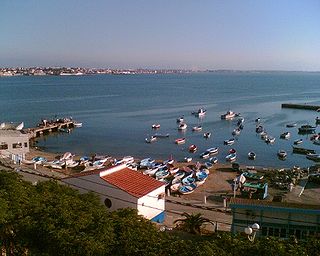
Igilgili was a Berber town and a Phoenician, Carthaginian, and Roman colony in located in present-day Jijel, Algeria.
| | |
| Shown within Algeria | |
| Location | Algeria |
|---|---|
| Region | Jijel Province |
| Coordinates | 36°49′00″N5°46′00″E / 36.816667°N 5.766667°E |
Igilgili was a Berber town and a Phoenician, Carthaginian, and Roman colony in located in present-day Jijel, Algeria.
Igilgili was initially a small Carthaginian colony and trading port (Punic : 𐤀𐤉𐤂𐤋𐤂𐤋, ʾYGLGL, or 𐤀𐤉𐤂𐤋𐤂𐤋𐤕, ʾYGLGLT). [1] This name seems to combine ʾY (Punic : 𐤀𐤉, "island") with a suffix that might be either Semitic or Berber. [2]
After the Punic Wars, Igilgili was given to Rome's allies in North Africa. After the defeat of Jugurtha by Rome and its allies in 105 BC, the city came under direct Roman rule. It was turned into a Roman colony under Augustus in 33 BC, giving its people Roman citizenship. Once the Romans occupied the whole of North Africa, the city of Igilgili was administratively attached to the Roman province of Mauretania Caesariensis and later to Mauretania Sitifensis. In those years, Igilgili grew to nearly 6,000 inhabitants and was very rich, with commerce to Italy and Iberia.
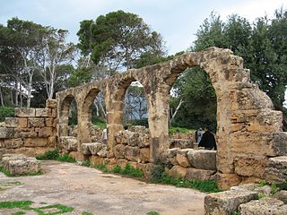
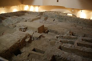
The site is on a low peninsula and a small coastal plain enclosed by a ring of hills, about half-way between Bône and Algiers. The Roman colony, founded by Augustus (Plin. HN 5.21), is mentioned by Ptolemy (4.2.2), in the Antonine Itinerary, the Peutinger Table, and in the Ravenna Geographer. It was a fairly important port until the Byzantine period. Six roads went out from it...The remains of town walls (which have now disappeared) belonged to the Roman period. An aqueduct comes from the S. To the SE of the knoll of St. Ferdinand were public baths. They have produced Dionysiac and ornamental mosaics, now at the Skikda Museum (formerly Philippeville), and sculptures (a satyr's head at the Algiers Museum). Other artifacts include statuettes, lamps, and votive stelae (at the Skikda Museum and the Louvre). M. Leglay [3]
Igilgili population and its surroundings became massively Christian in the fourth century, with the formalization of this religion under Emperor Constantine, although the first conversions date back to two centuries earlier. When emperor Valentinian I sent his magister militum Theodosius (father of Theodosius I) to attack Firmus, he landed in Igilgili in 374 AD; there Firmus tried to find a compromise with him, but Theodosius refused peace to Firmus, who had proclaimed himself emperor. With the support of the indigenous local African tribes, Firmus obliged Theodosius to a bloody and hopeless campaign in which Igilgili region was devastated for a couple of years. In the end, however, Firmus was betrayed by one of his supporters, and chose suicide over capture.
The Roman city remained rich until the attack and partial destruction by the Vandals in 429 AD. Subsequently, the city was taken in 533 AD by the Byzantine (Eastern Roman Empire) and their Romano-African supporters (Romanized Berber dwellers) from the Vandals. Catholicism and the Roman way of life were restored under the Byzantines, while the remaining Vandals took refuge in the surrounding mountains (of actual "Little Kabylie"). [4]
At the time of arrival of the Umayyads and Islam in the region in the late seventh century, Byzantine officials with troops and some Roman Catholic and Latinized Berbers lived in the city of Igilgili. While nearby of the city the camps were populated by peasants Berber "Kutama" (called Ucutamani by the Byzantines), not fully Christians.
Around 650 AD the first riders of Islam appeared. Queen Kahina was defeated in 698 AD by the Muslim troops of Hassan Ibn Numan and the city of Igilgili was renamed "Jijel". It was incorporated into the Umayyad empire. The population of the region, which was then mainly Christian, converted to Islam, and by the end of the eighth century it had already become overwhelmingly Muslim. The Arabic language there diffused slowly and gradually, replacing Latin in Jijel city only in the early eighth century.
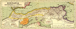
Mauretania is the Latin name for a region in the ancient Maghreb. It extended from central present-day Algeria to the Atlantic, encompassing northern present-day Morocco, and from the Mediterranean in the north to the Atlas Mountains. Its native inhabitants, of Berber ancestry, were known to the Romans as the Mauri and the Masaesyli.

The history of North Africa during the period of classical antiquity can be divided roughly into the history of Egypt in the east, the history of ancient Libya in the middle and the history of Numidia and Mauretania in the west.

Hadrumetum, also known by many variant spellings and names, was a Phoenician colony that pre-dated Carthage. It subsequently became one of the most important cities in Roman Africa before Vandal and Umayyad conquerors left it ruined. In the early modern period, it was the village of Hammeim, now part of Sousse, Tunisia.

Mauretania Caesariensis was a Roman province located in present-day Algeria. The full name refers to its capital Caesarea Mauretaniae.
Cherchell is a town on Algeria's Mediterranean coast, 89 kilometers (55 mi) west of Algiers. It is the seat of Cherchell District in Tipaza Province. Under the names Iol and Caesarea, it was formerly a Roman colony and the capital of the kingdoms of Numidia and Mauretania.
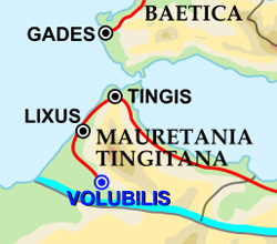
Tingis or Tingi, the ancient name of Tangier in Morocco, was an important Carthaginian, Moor, and Roman port on the Atlantic Ocean. It was eventually granted the status of a Roman colony and made the capital of the province of Mauretania Tingitana and, after Diocletian's reforms, the diocese of Hispania.

Saldae was an important port city in the ancient Roman Empire, located at today's Béjaïa. It was generally a crossroads between eastern and western segments of Northern Africa, from the time of Carthage to the end of the Byzantine Empire from the continent.
Tipasa, sometimes distinguished as Tipasa in Mauretania, was a colonia in the Roman province Mauretania Caesariensis, nowadays called Tipaza, and located in coastal central Algeria. Since 1982, it has been declared by UNESCO a World Heritage Site. It was declared a World Heritage Site in danger in 2002, but was removed from the danger list in 2006 following conservation efforts.
Abyla was the pre-Roman name of Ad Septem Fratres. Ad Septem Fratres, usually shortened to Septem or Septa, was a Roman colony in the province of Mauretania Tingitana and a Byzantine outpost in the exarchate of Africa. Its ruins are located within present-day Ceuta, an autonomous Spanish city in northwest Africa.

Icosium was a Phoenician and Punic settlement in modern-day Algeria. It was part of Numidia and later became an important Roman colony and an early medieval bishopric in the casbah area of modern Algiers.
Tamentfoust, the classical Rusguniae and colonial La Pérouse, is a site in the Dar El Beïda District of Algiers in Algeria.

Rusadir was an ancient Punic and Roman town at what is now Melilla, Spain, in northwest Africa. Under the Roman Empire, it was a colony in the province of Mauretania Tingitana.

Mauri was the Latin designation for the Berber population of Mauretania, located in the west side of North Africa on the shores of the Mediterranean Sea, Mauretania Tingitana and Mauretania Caesariensis, in present-day Morocco and northwestern Algeria.

Djinet, the classical Cissi, is a port town and commune in the Bordj Menaïel District of Boumerdès Province, Algeria, east of the mouth of the Isser River and around Cape Djinet. As of 2008, the population of the municipality is 21,966.

Cartennae or Cartenna was an ancient Carthaginian and Roman port at present-day Ténès, Algeria. Under the Romans, it was part of the province of Mauretania Caesariensis.
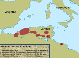
The Kingdom of Altava was an independent Christian Berber kingdom centered on the city of Altava in present-day northern Algeria. The Kingdom of Altava was a successor state of the previous Mauro-Roman Kingdom which had controlled much of the ancient Roman province of Mauretania Caesariensis. During the reign of Kusaila, it extended from Volubilis in the west to the Aurès and later Kairaouan and the interior of Ifriqiya in the east. This Kingdom collapsed following Eastern Roman military campaigns to decrease its influence and power after Garmul invaded the Exarchate of Africa.
Rusazus was a Phoenician, Carthaginian, and Roman town located near Cape Corbelin, Algeria. Its ruins are near the town of Azeffoun.
Rusubbicari was a Phoenician and Carthaginian colony and Roman town. It has been tentatively identified with ruins at Zemmouri El Bahri, Algeria. The Roman town was in the province of Mauretania Caesariensis.
Aquae Calidae was a Roman colony of the Roman province of Mauretania Caesariensis. The Roman city has been identified with ruins at Hammam Righa in the wilaya of Chlef, Algeria, North Africa.

The Mauro-Roman Kingdom, also described as the Kingdom of Masuna, was a Christian Berber kingdom which dominated much of the ancient Roman province of Mauretania Caesariensis from the capital city of Altava. Scholars are in disagreement about whether the polity aimed for independence as a kingdom or was part of a loose confederation, an alternative hypothesis drawn from contextual knowledge about Berber tribal alliances. In the fifth century, Roman control over the province weakened and Imperial resources had to be concentrated elsewhere, notably in defending the Roman Italy itself from invading Germanic tribes. Moors and Romans in Mauretania came to operate independently from the Empire. However, regional leaders may not have necessarily felt abandoned by the Romans.
| Algeria |
|
|---|---|
| Cyprus | |
| Greece | |
| Israel | |
| Italy | |
| Lebanon | |
| Libya | |
| Malta |
|
| Morocco | |
| Portugal |
|
| Spain | |
| Syria | |
| Tunisia | |
| Other | |
