"}" id="mwCA">
Gunugus or Gunugu (Punic : 𐤂𐤍𐤂𐤍, gngn) [1] was a Berber and Carthaginian town in northwest Africa in antiquity. It passed into Roman control during the Punic Wars and was the site of a colony of veteran soldiers. It survived the Vandals and Byzantines but was destroyed during the Muslim invasion of the area.
Gunugus has been tentatively—but not certainly—identified with the ruins at Sidi Brahim de Gouraya on the Mediterranean coast near Gouraya, Algeria. [2] [3]
Gunugus was a Berber and Carthaginian town from around 550 BC. [4] [5] It may have also been the site of a Greek colony at some point [6]
After the Punic Wars, Gunugus was the site of a Roman colony established by Augustus.
It was administered as part of the province of Caesarian Mauretania. The local Berbers made up a large part of the settlement as well.
Gunugus existed through the Vandal Kingdom and the Byzantine reconquest of Africa. [2] [7] It was destroyed around AD 640. [4] [5]
The town was also the seat of an ancient Roman Catholic bishopric. [8] [9] The only known bishop of this diocese is Ausilius, who took part in the synod assembled in Carthage in 484 by the Vandal King Huneric, after which Ausilius was exiled. Today Gunugo Diocese survives as a titular bishopric [10] of the Roman Catholic Church and the current bishop is Sylvester David, of Cape Town. [11]
Gunugu, on the Algerian coast near Gouraya, is significant as a former Roman settlement. [12] Founded by Emperor Augustus, Gunugu was originally known as a small town for veterans. [13] Despite this imperial backing, Gunugu did not experience significant growth under Roman rule. Its proximity to Caesarea, the provincial capital, probably limited its development.
The Roman town was much larger. Outside the ramparts, we still come across cisterns, ashlars and, to the south-east, a few shafts and soft, crude capitals in the decadent Ionic order, which seem to have belonged originally to a Christian church or chapel from around the 5th century: at this time, Gunugu was a bishopric. Quarries were exploited at the end of the promontory that bears the necropolis described later in this text.
Over time, Gunugu underwent changes in government and name, [14] eventually becoming known as Brechk under Muslim rule. [15] However, it remained a focus of regional conflict, as evidenced by its capture by Roger II of Sicily in 1144. [16]
In the late 15th century, Gunugu saw an influx of refugees, mainly Moors fleeing from Andalusia. [17] This demographic change gave a temporary boost to the city's economy and culture. Industries such as textile production flourished, as did agriculture in the surrounding fertile lands. [18] In addition, Gunugu became known for its corsairs who operated along the North African coast. This period of prosperity was short-lived, however, as the city fell to the onslaught of the Knights of St Stephen in 1610, leading to its eventual decline.
The remnants of Gunugu's ancient past are scattered across the landscape, [19] bearing witness to its rich history. Both Roman and Berber influences can be seen among the ruins, with traces of pottery, masonry and infrastructure. The sanctuary of Sidi Brahim, built from ancient materials, is particularly noteworthy, as are the remains of Roman reservoirs and an aqueduct. Despite the city's eventual decline, these archaeological remains offer a glimpse of its former grandeur and cultural heritage.
Gunugu boasts several ancient burial grounds that shed light on the various funerary practices prevalent in the region. [20] [21] The necropolises reveal a mixture of Phoenician and indigenous burial customs, with tombs carved into tufa rock. Some tombs have adjacent pits, suggesting communal burial practices. The presence of mixed bone remains indicates a complex interplay of cremation and non-cremation burial rites, reflecting the diverse cultural influences of the city's inhabitants.
Burial rites at Gunugu encompassed a range of practices reflecting the city's multicultural population. Grave goods were commonly placed alongside the deceased, reflecting the belief in an afterlife and the continuation of material existence after death. Ceramic vessels, both imported from Italy and locally made, were common burial offerings, underlining Gunugu's role as a hub of Mediterranean trade and commerce. The presence of cremation remains alongside traditional burials suggests cultural exchange and adaptation within the city's diverse community.
In most tombs, the remains of the deceased were simply laid on the floor, which had been lined with a bed of sand. In others, one or more benches, flat or hollowed with a more or less deep trough, had been created. The tomb depicted herein features two raised-edged layers, which, instead of taking the form of a basin, are open on the side of the bottom. Quite often, the shaft provides access to a second tomb, from a later period. Sometimes — the most common scenario — it opens opposite the first, while at other times, it is established on one of the long sides of the shaft. Each chamber contains a certain number of deceased individuals: in one of those we excavated, there were at least twenty-three. It is likely that after the burials, the shafts were backfilled with earth and rubble.
Three funeral rites were distinguished: the rarest involved simply laying the deceased on the ground, while another entailed haphazardly gathering bones, either on the floor, benches, troughs, or in clay vessels. Sometimes, a broken amphora served as a container. It was observed that these mixed human remains likely underwent defleshing before being buried. This suggests that our tombs were not family graves but likely brought together individuals from Gunugu who died around the same time.
In the Larhat (formerly Vileborug) region, remnants of an ancient dam, constructed with rubble, lime, and sand, were found near Toued Mellah. [22] This dam supplied water to the city of Gunugu (now Sidi-Brahim) via a canal constructed above the current road, lined with stone masonry and internally asphalted with crushed brick and lime. However, successive ground subsidence and seismic movements have largely destroyed this structure. Near the border between Larhat (formerly Vileborug) and Gouraya, the canal passed through a tunnel under a hill, where it remains relatively well preserved.
On the Harbil wadi, the remains of a small dam were discovered, likely intended to irrigate gardens on the left bank of the wadi. In the Gouraya region, traces of a reservoir basin, possibly used for irrigation, were found between the Messelmoun and Sebt wadis.
In the Menaceur (formerly Marceau) region, irrigation along the banks of the Rouman wadi was facilitated by a 7 to 8-meter-long dam. Ruins of an ancient aqueduct were also observed along the Aïzer wadi, with intact arches at both ends, as well as remnants of canalization along its left bank. Near Menaceur (formerly Marceau), the Zélazel wadi was diverted, and the canal remains visible above the current road. Similarly, the Zaouïa wadi was diverted, with remnants of the canal visible along the route from Zurich to Menaceur (formerly Marceau). These canals converged near the Bocquet farm and continued through the mountains, valleys, and aqueducts to Caesarea, providing water to the city. Additionally, remnants of a dam on the Zaouïa wadi, located 500 to 600 meters downstream from the diversion point, were found, though their significance and purpose remain unclear.
Coastal sites, as seen from Gunugu's perspective, serve as regular "staging posts" every 30 to 40 kilometers eastward. [23] Among them, Gunugu itself, dating back to the 5th century BCE, stands out, reflecting evolving economic ties while political allegiance to Carthage remains uncertain. The ancient city of Gunugu, now Breshk, is mentioned in historical texts with conflicting accounts regarding the presence of a port. While some sources indicate the absence of a formal port, others suggest the existence of a modest harbour or anchorage. Piri Reïs [24] asserts the lack of a port but notes abundant fish in the area, hinting at maritime activity. Additionally, Laurent [25] mentions a small harbour on the northeastern side of the island, suggesting limited maritime infrastructure.
Insights from Gsell and Cat (cited above) reveal remnants of a jetty and stairs near the promontory, supported by field surveys [26] uncovering reservoirs along the cliff walls overlooking the presumed port location, indicating potential water supply infrastructure for maritime activities.
However, challenges such as erosion and landslides obscure historical features, complicating confirmation of a port's presence. Despite this, Gunugu's strategic location along trade routes between Cartennae and Caesarea suggests probable maritime activity.
In conclusion, while evidence hints at maritime infrastructure in Gunugu, including reservoirs and potential remnants of jetties, further archaeological investigations are necessary to determine the port's extent and nature. Understanding Gunugu's maritime heritage is crucial given its historical significance as a trade hub in a strategic location.
Gunugu's archaeological record attests to its importance as a vibrant centre of trade and commerce in the ancient Mediterranean world. Imported pottery from Italy, including finely crafted vases and vessels, provides tangible evidence of maritime links and commercial exchange. While Roman-era treaties restricted direct Roman access to African ports, Gunugu probably served as an intermediary hub, receiving goods via Carthaginian merchants. This underlines the city's key role in facilitating trade networks and cultural exchange across the region.
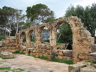
Carthage was an ancient city in Northern Africa, on the eastern side of the Lake of Tunis in what is now Tunisia. Carthage was one of the most important trading hubs of the Ancient Mediterranean and one of the most affluent cities of the classical world. It became the capital city of the civilisation of Ancient Carthage and later Roman Carthage.
Numidia was the ancient kingdom of the Numidians in northwest Africa, initially comprising the territory that now makes up Algeria, but later expanding across what is today known as Tunisia and Libya. The polity was originally divided between the Massylii state in the east and the Masaesyli in the west. During the Second Punic War, Masinissa, king of the Massylii, defeated Syphax of the Masaesyli to unify Numidia into the first unified Berber state for Numidians in present-day Algeria. The kingdom began as a sovereign state and an ally of Rome and later alternated between being a Roman province and a Roman client state.
Hippo Regius is the ancient name of the modern city of Annaba, Algeria. It served as an important city for the Phoenicians, Berbers, Romans, and Vandals. Hippo was the capital city of the Vandal Kingdom from AD 435 to 439. when it was shifted to Carthage following the Vandal capture of Carthage in 439.
Oea was an ancient city in present-day Tripoli, Libya. It was founded by the Phoenicians in the 7th century BC and later became a Roman–Berber colony. As part of the Roman Africa Nova province, Oea and surrounding Tripolitania were prosperous. It reached its height in the 2nd and 3rd centuries AD, when the city experienced a golden age under the Severan dynasty in nearby Leptis Magna. The city was conquered by the Rashidun Caliphate with the spread of Islam in the 7th century and came to be known as Tripoli during the 9th century.
Cirta, also known by various other names in antiquity, was the ancient Berber, Punic and Roman settlement which later became Constantine, Algeria.
Mauretania Caesariensis was a Roman province located in present-day Algeria. The full name refers to its capital Caesarea Mauretaniae.
Cherchell is a town on Algeria's Mediterranean coast, 89 kilometers (55 mi) west of Algiers. It is the seat of Cherchell District in Tipaza Province. Under the names Iol and Caesarea, it was formerly a Roman colony and the capital of the kingdoms of Numidia and Mauretania.
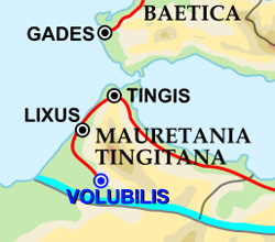
Tingis or Tingi, the ancient name of Tangier in Morocco, was an important Carthaginian, Moor, and Roman port on the Atlantic Ocean. It was eventually granted the status of a Roman colony and made the capital of the province of Mauretania Tingitana and, after Diocletian's reforms, the diocese of Hispania.
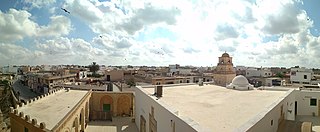
El Djem or El Jem is a town in Mahdia Governorate, Tunisia. Its population was 21,544 at the 2014 census. It is home to Roman remains, including the Amphitheatre of El Jem.
Saldae was an important port city in the ancient Roman Empire, located at today's Béjaïa. It was generally a crossroads between eastern and western segments of Northern Africa, from the time of Carthage to the end of the Byzantine Empire from the continent.
Muhammad bin Ali al-Hawzali is the most important author in the literary tradition of the Tachelhit language. He was born around 1680 in the village of al-Qaṣaba (Elqeṣba) in tribal territory of the Induzal, in the region of Sous in Morocco and died in 1749.
Maktar or Makthar, also known by other names during antiquity, is a town and archaeological site in Siliana Governorate, Tunisia.
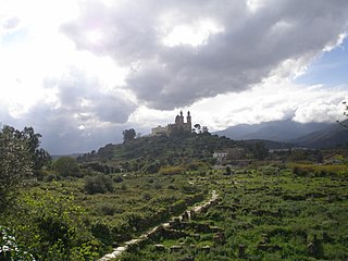
Tipasa, sometimes distinguished as Tipasa in Mauretania, was a colonia in the Roman province Mauretania Caesariensis, nowadays called Tipaza, and located in coastal central Algeria. Since 1982, it has been declared by UNESCO a World Heritage Site. It was declared a World Heritage Site in danger in 2002, but was removed from the danger list in 2006 following conservation efforts.
Althiburos was an ancient Berber, Carthaginian, and Roman settlement in what is now the Dahmani Delegation of the Kef Governorate of Tunisia. During the reign of emperor Hadrian, it became a municipality with Italian rights. It was the seat of a Christian bishop from the 4th to 7th centuries. The settlement was destroyed during the Muslim invasions and the area's population center moved to Ebba Ksour on the plain. This left Althiburos's ruins largely intact; they were rediscovered by travelers in the 18th century.
Sidi Ghiles is a town on Algeria's Mediterranean coast. The municipality of Novi is located about 32 kilometres (20 mi) west of Tipasa and 7 kilometres (4.3 mi) southwest of Cherchell. This agricultural locality is 100 kilometres (62 mi) from Algiers.
Caesarea in Mauretania was a Roman colony in Roman-Berber North Africa. It was the capital of Mauretania Caesariensis and is now called Cherchell, in modern Algeria.
Madauros was a Roman-Berber city and a former diocese of the Catholic Church in the old state of Numidia, in present-day Algeria.
Cartennae or Cartenna was an ancient Carthaginian and Roman port at present-day Ténès, Algeria. Under the Romans, it was part of the province of Mauretania Caesariensis.
Iomnium was a Phoenician, Carthaginian, and Roman port on Algeria's Mediterranean coast at the site of present-day Tigzirt.
Rusguniae is an ancient archaeological site located in the commune of El Marsa, in the wilaya of Algiers, Algeria.