Ténès

Last updated • 3 min readFrom Wikipedia, The Free Encyclopedia
تنس
Skyview of Tenes Skyview-tenes.jpg
Skyview of Ténès
DZ 02 Tenes.svg
within the Chlef wilaya
Coordinates: 36°30′44″N1°18′16″E / 36.51222°N 1.30444°E / 36.51222; 1.30444
CountryFlag of Algeria.svg  Algeria
Province Chlef Province
District Ténès [1]
Area
  Total101 km2 (39 sq mi)
Elevation
779 m (2,556 ft)
Population
 (2008 [2] )
  Total35,459
  Density350/km2 (910/sq mi)
  Summer (DST) UTC+1 (CET)
Cap Ténès Lighthouse OOjs UI icon edit-ltr-progressive.svg
Perle de tenes.jpg
Constructed1861  OOjs UI icon edit-ltr-progressive.svg
Foundationstone base
Constructionstone tower
Height31.50 metres (103.3 ft) [3]
Shapequadrangular tower with balcony and lantern [4]
Markingswhite lantern, dark green lantern
Power sourcemains electricity  OOjs UI icon edit-ltr-progressive.svg
OperatorNational Maritime Signaling Office  OOjs UI icon edit-ltr-progressive.svg
Focal height94.50 metres (310.0 ft) [3]
Intensity1,000 W
Range29 nautical miles (54 km; 33 mi) [3] [5]
Characteristic Fl(2) W 10s  OOjs UI icon edit-ltr-progressive.svg

Ténès (Arabic : تنس; from Berber TNS 'camping') is a town in Algeria located around 200 kilometers west of the capital Algiers. As of 2000, it has a population of 65,000 people.

Contents

History

Ruins in Tenes Tenes ruines, Algeria.jpg
Ruins in Ténès

Ténès was founded as a Phoenician port [6] in or before the 8th century BC. As with other Phoenician harbors, it fell under the hegemony of Carthage around the 6th century BC and of the Romans after the Punic Wars. Its Punic name was Latinized as Cartenna or Cartennae, a plural which suggested the existence of a separate Berber settlement nearby. Ptolemy mentions that the local tribes were known as the "Bakoyta". [7] The city rose to colony status under the empire. [6]

It was sacked by the Vandals during their conquest of Roman North Africa. [6] Reconquered by the Byzantines and then taken by the Umayyad Caliphate, it disappeared except for a mostly ruined fortification. [6]

Medieval Ténès was founded by Spaniards in the 9th century; Al-Bakri dates it to 875 or 876 (262  AH). They established their base 3.2 km (2 mi) from the former settlement. They invited settlers from Elvira and Murcia but many left owing to outbreaks of fever among the new settlers. [6] They were replaced by Berbers from Suk Ibrahim on the Chelif. [6] The city prospered in spite of an unhealthy climate owing to the fertility of the surrounding countryside, which produced fruit and grain in relative abundance. [6]

A local dynasty claiming descent from Ali prospered for a time. They recognized as their overlords the Umayyads, who treated the town as a kind of prison camp for exiles. [6] After the 10th century, it passed in succession under Fatimid, Sanhaja, Maghrawa, Almoravid, Almohad, and Ziyanid control. In the later 15th century, it prospered amid the exodus of Moors from the War of Granada.[ citation needed ] The locals overthrew the last of its foreign rulers and established a local sheikh, whose dynasty was eventually compelled to become vassals of Spain. [6]

Ténès was sacked by Oruç Reis in 1517 and conquered for the Ottoman Empire by his brother Hayreddin Barbarossa a few years later. [6] The town was given a garrison but its economic life gradually collapsed, with its European trade in grain gone by the 18th century. [6] Berber revolts sacked the city and attempted to overthrow Ottoman rule on several occasions. [6]

Following the French invasion of Algiers in 1830, Ténès fell under the control of the Emir Abdelkader, who tried to revive its port. [6] The locals finally surrendered to the French without a fight in 1843. [6] Bugeaud then used it as a base to control the Chelif Valley. [6]

Mistaken accounts in the ancient geographers originally caused the French to assume ancient Cartennae had been at Mostaganem, but engravings were soon discovered by archaeologists which established the correct identification. [8] Modern Ténès was established at the ruins of the Phoenician and Roman colony by the French in 1847. [8] Its harbor about 1.5 km distant originally served as a port for goods from the Chelif, but declined following the construction of the Algiers–Oran railway. [8]

Present

At the present time Ténès is a small tourist town with five small hotels, two hospitals, a local museum, a port and a lighthouse. It has some antique sites such as the Phoenician and Roman tombs, the prehistoric caves in Sidi Merouane, the Great Mosque of Sidi Ahmed Boumaza [9] (built some 11 centuries ago), Bab El Bahr, Notre Dame de Ténès, The French cannons, along with many others.

See also

Related Research Articles

<span class="mw-page-title-main">History of Algeria</span>

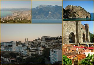
Much of the history of Algeria has taken place on the fertile coastal plain of North Africa, which is often called the Maghreb. North Africa served as a transit region for people moving towards Europe or the Middle East, thus, the region's inhabitants have been influenced by populations from other areas, including the Carthaginians, Romans, and Vandals. The region was conquered by the Muslims in the early 8th century AD, but broke off from the Umayyad Caliphate after the Berber Revolt of 740. During the Ottoman period, Algeria became an important state in the Mediterranean sea which led to many naval conflicts. The last significant events in the country's recent history have been the Algerian War and Algerian Civil War.

<span class="mw-page-title-main">Berbers</span> Ethnic group indigenous to North Africa

Berbers, or the Berber peoples, also called by their endonym Amazigh or Imazighen, are a diverse grouping of distinct ethnic groups indigenous to North Africa who predate the arrival of Arabs in the Arab migrations to the Maghreb. Their main connections are identified by their usage of Berber languages, most of them mutually unintelligible, which are part of the Afroasiatic language family. They are indigenous to the Maghreb region of North Africa, where they live in scattered communities across parts of Morocco, Algeria, Libya, and to a lesser extent Tunisia, Mauritania, northern Mali and northern Niger. Smaller Berber communities are also found in Burkina Faso and Egypt's Siwa Oasis.

<span class="mw-page-title-main">Medieval Muslim Algeria</span>

Medieval Muslim Algeria was a period of Muslim dominance in Algeria during the Middle Ages, spanning the millennium from the 7th century to the 17th century. The new faith, in its various forms, would penetrate nearly all segments of society, bringing with it armies, learned men, and fervent mystics; in large part, it would replace tribal practices and loyalties with new social norms and political idioms.

<span class="mw-page-title-main">Kabylia</span> Region of northern Algeria inhabited by Kabyle people

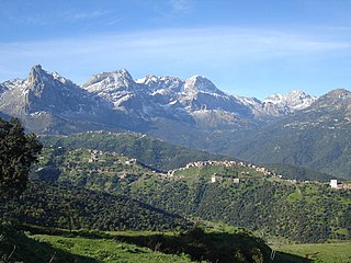
Kabylia or Kabylie is a mountainous coastal region in northern Algeria and the homeland of the Kabyle people. It is part of the Tell Atlas mountain range and is located at the edge of the Mediterranean Sea.

<span class="mw-page-title-main">Dellys</span> City in Algeria

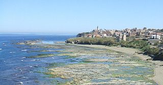
Dellys is a small Mediterranean town in northern Algeria's coastal Boumerdès Province, almost due north of Tizi-Ouzou and just east of the Sebaou River. It is the district seat of the daïra of Dellys. The town is 45 km from Tizi Ouzou, 50 km from Boumerdes, and about 100 km from the capital Algiers.

<span class="mw-page-title-main">Chlef Province</span> Province of Algeria

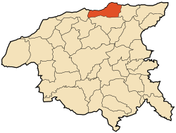
Chlef is a province (wilaya) in Algeria. Its capital and biggest city is Chlef. It is the 8th most populous province in the country, having just over 1 million inhabitants.

<span class="mw-page-title-main">Béjaïa</span> City and commune in Béjaïa Province, Algeria

Béjaïa formerly Bougie and Bugia, is a Mediterranean port city and commune on the Gulf of Béjaïa in Algeria; it is the capital of Béjaïa Province.

<span class="mw-page-title-main">Mostaganem</span> City in Mostaganem Province, Algeria

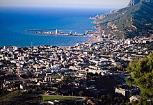
Mostaganem is a port city in and capital of Mostaganem province, in the northwest of Algeria. The city, founded in the 11th century lies on the Gulf of Arzew, Mediterranean Sea and is 72 km ENE of Oran. It is considered as the second-largest city in the country's northwest, after Oran, and as Algeria's fourth-largest port city with its 457,986 inhabitants as of the 2018 census.

<span class="mw-page-title-main">Cherchell</span> Town in Tipaza, Algeria

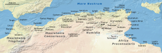
Cherchell is a town on Algeria's Mediterranean coast, 89 kilometers (55 mi) west of Algiers. It is the seat of Cherchell District in Tipaza Province. Under the names Iol and Caesarea, it was formerly a Roman colony and the capital of the kingdoms of Numidia and Mauretania.

<span class="mw-page-title-main">Chlef</span> City in Algeria

Chlef is the capital of Chlef Province, Algeria. Located in the north of Algeria, 200 kilometres (120 mi) west of the capital, Algiers, it was founded in 1843, as Orléansville, on the ruins of Roman Castellum Tingitanum. In 1962, it was renamed al-Asnam, but after the devastating earthquake on October 10, 1980, it has borne its present name, Chlef, which is derived from the name of the Chelif River, the longest river in Algeria.

<span class="mw-page-title-main">Miliana</span> Commune and town in Aïn Defla, Algeria

Miliana is a commune in Aïn Defla Province in northwestern Algeria. It is the administrative center of the daïra, or district, of the same name. It is approximately 114 kilometres (71 mi) southwest of the Algerian capital, Algiers. The population was estimated at 44,201 in 2008. The town is located south of the Dahra Range, on the wooded southern flank of Mount Zaccar Rherbi, five kilometers north of the Chelif River, and overlooking the Zaccar plateau to the west.

<span class="mw-page-title-main">El Amra</span> Place in Aïn Defla, Algeria

El Amra is a town in northern Algeria.

<span class="mw-page-title-main">Icosium</span>

Icosium was a Phoenician and Punic settlement in modern-day Algeria. It was part of Numidia and later became an important Roman colony and an early medieval bishopric in the casbah area of modern Algiers.

<span class="mw-page-title-main">Tamentfoust</span> Site in the Dar El Beïda District of Algiers in Algeria

Tamentfoust, the classical Rusguniae and colonial La Pérouse, is a site in the Dar El Beïda District of Algiers in Algeria.

<span class="mw-page-title-main">Ténès District</span> District in Chlef Province, Algeria

Ténès District is a district of Chlef Province, Algeria.

<span class="mw-page-title-main">Djinet</span> Commune and town in Boumerdès, Algeria

Djinet, the classical Cissi, is a port town and commune in the Bordj Menaïel District of Boumerdès Province, Algeria, east of the mouth of the Isser River and around Cape Djinet. As of 2008, the population of the municipality is 21,966.

<span class="mw-page-title-main">Oued Fodda</span> Commune and town in Chlef Province, Algeria

Oued Fodda is a town and commune in Chlef Province, Algeria. According to the 1998 census it has a population of 36,187.

<span class="mw-page-title-main">Igilgili</span> Archaeological site in Algeria

Igilgili was a Berber town and a Phoenician, Carthaginian, and Roman colony in located in present-day Jijel, Algeria.

<span class="mw-page-title-main">Cartennae</span> Ancient city in Mauretania Caesariensis

Cartennae or Cartenna was an ancient Carthaginian and Roman port at present-day Ténès, Algeria. Under the Romans, it was part of the province of Mauretania Caesariensis.

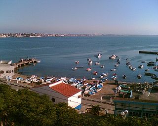
The Casbah of Dellys is a historic kasbah or medina quarter, the old town in the city of Dellys, Algeria. The kasbah is known for Ottoman Algeria-era buildings and cityscape. Today it is a favorite spot for tourism in Boumerdès Province.

References

Citations

  1. "Décret executif n° 91-306 du 24 août 1991 fixant la liste des communes animées par chaque chef de daïra. 02 - Wilaya de Chlef" [List of municipalities animated by each District chief: 02 - Chlef Province](PDF) (in French). Journal officiel de la République Algérienne. 4 September 1991. p. 1294. Retrieved 25 October 2019.
  2. "Wilaya de Chlef : répartition de la population résidente des ménages ordinaires et collectifs, selon la commune de résidence et la dispersion" (PDF) (in French).. Data from the 2008 General Population and Housing Census on the site of the NOS Algeria.
  3. 1 2 3 "Cap Tenes". Office Nationale de Signalisation Maritime. Ministere des Travaux Publics. Retrieved 28 April 2017.
  4. Rowlett, Russ. "Lighthouses of Western Algeria". The Lighthouse Directory. University of North Carolina at Chapel Hill . Retrieved 28 April 2017.
  5. List of Lights, Pub. 113: The West Coasts of Europe and Africa, the Mediterranean Sea, Black Sea and Azovskoye More (Sea of Azov) (PDF). List of Lights . United States National Geospatial-Intelligence Agency. 2015.
  6. 1 2 3 4 5 6 7 8 9 10 11 12 13 14 15 Yver (1927).
  7. Playfair, Robert Lambert (1891). Handbook for Travellers in Algeria and Tunis. J. Murray. pp. 246–247. Retrieved 18 March 2018.
  8. 1 2 3 Playfair (1874) , s.v. "Tenes".
  9. http://www.boumazasofi.jeeran.com [ dead link ]

Bibliography