The Danube was not always or everywhere used by the Romans as the military frontier which was moved north or south in some locations according to military conquests, but it was maintained in many places as a fairly permanent defensive structure for long periods. The border was reinforced with numerous watchtowers, legion camps (castra) and forts (castella). Due to the boggy and dendritic nature of the Danube's river banks no border ramparts were built, unlike the Neckar-Odenwald Limes in Germany. The camps were built in the mid-1st century. Later, under Trajan, the camps, which had originally only been surrounded by earthen embankments, were enclosed by stone walls.
A Roman road, the Danube Way (Latin: Via Istrum) was laid along the limes, which linked the stations, camps and forts as far as the Danube Delta.[1]
In 2021, the western segment of the Danube Limes were inscribed on the UNESCOWorld Heritage List as part of the set of "Frontiers of the Roman Empire" World Heritage Sites.[2]
Subdivisions
Because of the sheer length of this border, the Danubian Limes is often divided into the following subdivisions:
Rhaetian Limes, only those elements along the Danube being counted as part of the Danubian Limes.
The Upper Germanic-Rhaetian Limes between the Rhine and the Danube
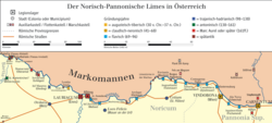
The Noric-Pannonian Limes in present-day Austria
The Pannonian Limes in present-day Slovakia, Hungary, Croatia and Serbia
A snapshot of The Moesian Limes of one period in present-day Bulgaria and Romania
Germany and Austria
The Salz Tower (Salzturm) in Tulln, Lower Austria, the former western horseshoe tower (Hufeisenturm) at Comagena
The oldest Roman camp in Austria was Carnuntum. Fourteen kilometres away to the west an auxiliary fort (Hilfskastell) was built near Schlögen (today in the municipality of Haibach ob der Donau) in Upper Austria. At that time, the limes ran from Vienna to Linz roughly following the present-day Wiener Straße (B1).
Because the Danube did not always provide adequate protection, bridgeheads were built on its northern banks against the Marcomanni, such as the one in Stillfried or at the Oberleiser Berg. However, these were cleared again under Marcus Aurelius' son, Commodus, and a seven-kilometre-wide 'death strip' was laid along the Danube.
The increasing number of fortifications that were falling into decay were renovated again under Emperor Valentinian I (364–375) and upgraded to the conform to the latest military tactics. Walls were thickened, and defensive ditches renewed. In addition, towers were built along the walls, such as a watchtower discovered near Oberranna in 1960. These fortifications lasted only another hundred years before the fall of the Roman Empire. In 488 the land of present-day Austria was cleared. The Roman fortifications along the lower courses of the Danube were overhauled once again, especially under Anastasios I and Justinian I. They finally served during Maurice's Balkan campaigns his successor, Phocas, as a basis for larger military operations and some were maintained in the province of Moesia Secunda until the invasion of the Bulgars in 679.
A few defensive towers survive: in Bacharnsdorf in Lower Austria, in Mautern (Favianis) and in Traismauer (Augustiana). In Tulln and Zeiselmauer, too, there are surviving remnants. In the Kürnberg Forest near Linz there are remains of a watchtower from the Roman period.
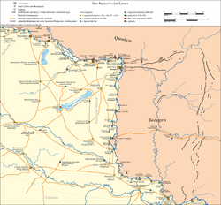
In 103 AD, Emperor Trajan divided the province of Pannonia into two parts: Pannonia Superior and Pannonia Inferior, or Lower Pannonia. The Lower Pannonia province ran along the eastern side of the Danube, today a part of Hungary, Serbia, Croatia, and Bosnia and Herzegovina. Colonies and towns were built throughout the area on both sides of the Danube, in addition to Roman forts, garrisons, and bases. Some of the most notable were:
Roman provinces and barbarians at the Lower Danube around 200 ADThe Lower Danubian Limes and the northern Balkans in the 6th century. Depicted are the provinces, major settlements and military roads
The Lower Danubian Road was built under Emperor Tiberius in the 1st century AD on the right (southern) bank of the river and forts and watchtowers were also built as part of the limes linked by the road. The following Roman forts were the first to be established here during the 1st century:[citation needed]
Ralph F. Hoddinott: Bulgaria in Antiquity. An archeological introduction. Ernest Benn Ltd., London, 1975, ISBN0-510-03281-8, pp.111–142.
Kurt Genser: Der Donaulimes in Österreich (= Schriften des Limesmuseums Aalen. Vol. 44). Württembergisches Landesmuseum, Stuttgart, 1990.
Gerda von Bülow et al. (eds.): Der Limes an der unteren Donau von Diokletian bis Heraklios. Vorträge der Internationalen Konferenz Svištov, Bulgarien (1–5 September 1998). Verlag NOUS, Sofia, 1999, ISBN954-90387-2-6.
Susanne Biegert (ed.): Von Augustus bis Attila. Leben am ungarischen Donaulimes (= Schriften des Limesmuseums Aalen. Vol. 53). Theiss, Stuttgart, 2000, ISBN3-8062-1541-3.
Herwig Friesinger et al. (eds.): Der römische Limes in Österreich. Führer zu den archäologischen Denkmälern. 2nd, revised edition. Verlag der Österreichischen Akademie der Wissenschaften, Vienna, 2002, ISBN3-7001-2618-2.
Sonja Jilek: Grenzen des Römischen Reiches: Der Donaulimes, eine römische Flussgrenze. Uniwersytet Warszawski, Warsaw, 2009, ISBN978-83-928330-7-9.
Breeze, David J.; Schwarcz, Andreas; Ployer, René (2023). The Danube limes in Austria. Oxford: Archaeopress. ISBN9781803276083.
This page is based on this Wikipedia article Text is available under the CC BY-SA 4.0 license; additional terms may apply. Images, videos and audio are available under their respective licenses.