Ilok

Last updated
Ilok
Grad Ilok
Town of Ilok
Ilok.JPG
Ilok vinski podrum.jpg
Ilok Principovac.jpg
Lucka uprava Ilok 221208.jpg
Crkva sv Ivana Kapistrana ulaz mozaik 221208.jpg
Ilocki vinogradi - panoramio.jpg
Ilok jewish cemetery C.jpg
Photographs of Ilok
Flag of Ilok.gif
Ilok-HR-coat.gif
The Town of Ilok.png
Vukovar-Srijem County OpenStreetMap.svg
Red pog.svg
Ilok
Location of Ilok in Croatia
Croatia location map.svg
Red pog.svg
Ilok
Ilok (Croatia)
Europe blank laea location map.svg
Red pog.svg
Ilok
Ilok (Europe)
Coordinates: 45°13′19″N19°22′31″E / 45.22194°N 19.37528°E / 45.22194; 19.37528
Country Flag of Croatia.svg  Croatia
Region Syrmia (Podunavlje)
County Flag of Vukovar-Syrmia County.svg  Vukovar-Syrmia
Government
  MayorMarina Budimir
Area
[1]
   Town 129.0 km2 (49.8 sq mi)
  Urban
57.7 km2 (22.3 sq mi)
Elevation
110 m (360 ft)
Population
 (2021) [2]
   Town 5,045
  Density39/km2 (100/sq mi)
   Urban
3,842
  Urban density67/km2 (170/sq mi)
Demonym(s) Iločanin () Iločanka ()
(per grammatical gender)
Time zone UTC+1 (CET)
  Summer (DST) UTC+2 (CEST)
Postal code
32236
Area code +385 (0)32
Website ilok.hr
Ilok Castle Ilok.jpg
Ilok Castle

Ilok (pronounced [ilok] ) is the easternmost town in Croatia forming a geographic salient surrounded by Vojvodina. Located in the Syrmia region, it lies on the Fruška Gora hill overlooking the Danube river, which forms the border with the Bačka region of Serbia. The town is home to a Franciscan monastery and Ilok Castle, which is a popular day trip for domestic and cross-border tourists.

Contents

Name

In Croatian, the town is known as Ilok, in German as Illok, in Hungarian as Újlak, in Serbian Cyrillic as Илок and in Turkish as Uyluk. In Hungarian language "Újlak" means "new dwelling or lodge".

History

The area of present-day Ilok was populated since the neolithic and Bronze Ages. One Scordisci archaeological site dating back to late La Tène culture was excavated in the 1970s and 1980s as a part of rescue excavations in eastern Croatia. [3] The Romans settled there in the 1st or 2nd century and built Cuccium, the first border fortification on the Danube. The Slavs settled here in the 6th century. The area was later ruled by the Bulgarian Empire, with a period of Frankish and Croat rule under Ljudevit Posavski, but after that the Bulgarians return, and stayed there until it was included into the medieval Kingdom of Hungary.

In 12th and 13th centuries the market-town of Ilok was mentioned in documents under various names (Iwnlak, Vilak, Vylok, Wyhok, Wylak). At the end of the 13th century, Hungarian kings gave the Vylak castrum to the powerful Csák noble family. In the 13th and 14th centuries, Ilok was a capital of the semi-independent medieval state of Upper Syrmia ruled by Ugrin Csák.

After 1354, the town of Ilok belonged to Nicholas and Paul Garay (in Croatian references Gorjanski), and then to Nicholas Kont of Orahovica and his descendants, among which was his grandson Ladislaus, great-grandson Nicholas and the last member of the Újlaki (Iločki) family - Lawrence. Nicholas was the Ban of All Slavonia from 1457 to 1463, and his son, Lawrence was a duke of Syrmia from 1477 to 1524.

In 1526, the town came under Ottoman rule. During this time, it was mainly populated by Muslims. In 1566–69, Ilok had 238 Muslim and 27 Christian houses. In 1572, it had 386 Muslim, and 18 Christian houses. In 1669, the population of Ilok numbered 1,160 houses, and town possessed two mosques. It was kaza centre in Sanjak of Syrmia. Habsburg army firstly occupied Ilok in 1688, but Ottomans recaptured it in 1690. In 1697, Habsburg army definitively retook Ilok from the Ottomans and the Muslim population fled.

During the Habsburg rule, Ilok belonged to the Kingdom of Slavonia, a Habsburg province that belonged to both the Kingdom of Croatia, and the Kingdom of Hungary. Between 1849 and 1868, the Kingdom of Slavonia was completely separate Habsburg crownland, and in 1868 it was joined with the Kingdom of Croatia to form the Kingdom of Croatia-Slavonia. In the late 19th and early 20th century, Ilok was a district capital in the Syrmia County of the Kingdom of Croatia-Slavonia.

In 1918, Ilok first became part of the State of Slovenes, Croats and Serbs, and then part of the Kingdom of Serbs, Croats and Slovenes (in 1929 renamed Kingdom of Yugoslavia). From 1929 to 1939, Ilok was part of the Danube Banovina and, from 1939 to 1941, of the Banovina of Croatia within the Kingdom of Yugoslavia. Between 1941 and 1944, during the Axis occupation of Yugoslavia, it belonged to the Independent State of Croatia. From 1945 onward, it was part of the People's Republic of Croatia within Socialist Yugoslavia.

On 17 October 1991 during the beginning of the Croatian War of Independence, non-Serbs fled as the Yugoslav People's Army led by Serb paramilitaries occupied the area, but spared it from destruction due to its rapid surrounding and occupation. Between 1991 and 1995, Ilok was part of the Republic of Serb Krajina. The area was peacefully reintegrated into Croatia in 1998.

Ilok is underdeveloped municipality which is statistically classified as the First Category Area of Special State Concern by the Government of Croatia. [4]

Demographics

According to the 2021 census, the town proper had 3,928 inhabitants, and the whole municipality of Ilok had 5,147. Before the 2001 census, the town was considered part of the old municipality of Vukovar. With pronounced issue of population decline in eastern Croatia caused by population ageing, effects of the Croatian War of Independence and emigration after the accession of Croatia to the European Union, the population of the town and three suburban settlements at the time of 2021 census dropped to 5,045 from 2011 population of 6,767.

Town of Ilok: Population trends 1857–2021
population
5954
7040
6547
7699
7865
8451
9130
9458
8839
9280
10049
10449
9891
9748
8351
6767
5045
18571869188018901900191019211931194819531961197119811991200120112021
Population by settlements1991200120112021
Bapska 1,6241,313928658
Ilok6,7755,8975,0723,842
Mohovo 344303239183
Šarengrad 1,005838528362
Total9,7488,3516,7675,045
Population by ethnicity199120012011
Croats 6,848 (70.25%)6,425 (76.94%)5,189 (76.68%)
Slovaks 1,192 (12.22%)1,044 (12.50%)935 (13.82%)
Serbs 680 (6.97%)566 (6.78%)439 (6.49%)
Hungarians 115 (1.17%)98 (1.17%)78 (1.15%)
others913 (9.36%)218 (2.61%)126 (1.86%)
Total9,7488,3516,767

2011 census

Municipality of Ilok [5]
Population by ethnicity

total: 6,767

   Croats 5,189 (76.68%)
   Slovaks 935 (13.82%)
   Serbs 439 (6.49%)
   Hungarians 78 (1.15%)
   Rusyns 19 (0.28%)
   Macedonians 14 (0.21%)
   Germans 12 (0.18%)
   Albanians 10 (0.15%)
   Montenegrins 3 (0.04%)
   Bosniaks 2 (0.03%)
   Slovenes 2 (0.03%)
   Czechs 1 (0.01%)
   Roma 1 (0.01%)
  declared religion 5 (0.07%)
  regional affiliation 1 (0.01%)
  others 5 (0.07%)
  nondeclared 36 (0.53%)
  not classified 2 (0.03%)
  unknown 13 (0.19%)

Ilok (settlement)

Settlement of Ilok: Population trends 1857–2021
population
3110
3776
3489
4288
4387
4856
5475
5809
5361
5696
6193
6683
6700
6775
5897
5072
3842
18571869188018901900191019211931194819531961197119811991200120112021

1991 census

Ilok [6]
Population by ethnicity

total: 6,775

   Croats 4,248 (62.70%)
   Slovaks 1,157 (17.07%)
   Serbs 484 (7.14%)
   Yugoslavs 474 (6.99%)
   Hungarians 105 (1.54%)
   Rusyns 28 (0.41%)
   Albanians 10 (0.14%)
   Muslims 10 (0.14%)
   Macedonians 9 (0.13%)
   Montenegrins 8 (0.11%)
   Germans 5 (0.07%)
   Czechs 2 (0.02%)
   Slovenes 2 (0.02%)
   Ukrainians 1 (0.01%)
  others 2 (0.02%)
  nondeclared 145 (2.14%)
  regionaly declared 7 (0.10%)
  unknown 78 (1.15%)

1910 census

According to the 1910 census, settlement of Ilok had 4,856 inhabitants (in the main settlement Ilok 4,809 and in hamlet of Principovac 47), which were linguistically and religiously declared as this:

Ilok [6]
Population by languagePopulation by religion

total: 4,856

   Croatian 2,729 (56.19%)
   Slovak 840 (17.29%)
   German 571 (11.75%)
   Serbian 448 (9.22%)
   Hungarian 254 (5.23%)
   Czech 7 (0.14%)
   Rusyn 5 (0.10%)
   Slovene 1 (0.02%)
  others 1 (0.02%)

total: 4,856

   Rom. Cath. 3,325 (68.47%)
   Lutherans 646 (13.30%)
   East. Orthodox 450 (9.26%)
   Jewish 213 (4.38%)
   Calvinists 204 (4.20%)
   East. Catholics 16 (0.32%)
  others 2 (0.04%)

Slovaks in Ilok

Karol Miloslav Lehotsky - Slavici ostrov pri Iloku - O 624 - Slovak National Gallery.jpg
Slovak national house Ilok opening invitation.jpg
1) Nightingale Isle by Ilok by Slovak painter Karol Miloslav Lehotský
2) 1952 invitation to the opening of the Slovak House, Museum of Vojvodina Slovaks

Ilok is one of the centres of the cultural life of the Slovaks of Croatia community. [7] Ilok Slovak community is closely linked with Slovaks in Serbia where there are Slovak communities and Slovak majority villages just across the border and with Slovak language being one of the official languages in Vojvodina.

Once Evangelical Slovaks were granted the right to settle and buy property in the Kingdom of Slavonia in 1859 Slovak settlers across the Danube river in Bačka started to move to Syrmia. [8] Slovak Evangelical Church of the Augsburg Confession established the local parish in Ilok in 1864 with building serving a place of worship, a school and a teacher's apartment. [8] The Slovak Evangelical school, which existed until 1896, was at the time was one of four confessional schools in the town alongside Croat Catholic, Serb Orthodox and the Jewish Israelite school. [8] State sponsored school education in Ilok was reinitiated in 1922 after the establishment of the Kingdom of Serbs, Croats and Slovenes and the public Slovak school will continue its work until 1957. [8] The first Slovak cultural association was established by students of the local gymnasium in 1925 which in the same year joined the Association of Czechoslovak Academicians in Yugoslavia. [9] The Slovak Reading Society was established in 1928 which preserved that name until 1951 when it changed the name into contemporary name the Slovak Cultural and Educational Association Ľudovít Štúr . [9]

Slovak branch of the national Union of Czechs and Slovaks was established in Ilok in 1981 with Slovak cultural life continuing even during the Croatian War of Independence. [9] Following the completion of the United Nations Transitional Administration for Eastern Slavonia, Baranja and Western Sirmium Slovak Cultural and Educational Association Ľudovít Štúr joined the Union of Slovaks in Croatia while local Matica slovenská was established on 18 December 1997. [9] In that period Slovak community used the right to organize Slovak language education for the first four grades until 2002/2003 school year after which only elective Slovak classes were offered. [8] In 2014 local community commemorated 140 years of the existence of the Evangelical-Slovak Church in Ilok. [10]

Politics

Minority councils and representatives

Directly elected minority councils and representatives are tasked with consulting tasks for the local or regional authorities in which they are advocating for minority rights and interests, integration into public life and participation in the management of local affairs. [11] At the 2023 Croatian national minorities councils and representatives elections Slovaks and Serbs of Croatia each fulfilled legal requirements to elect 15 members minority councils of the Town of Ilok. [12]

Ilok pogled na Dunav.jpg
Panoramic view of the Danube in Ilok with the Serbian town of Bačka Palanka on the other side of the river.

Notable people

See also

Related Research Articles

<span class="mw-page-title-main">Sremski Karlovci</span> Town and municipality in Vojvodina, Serbia

Sremski Karlovci is a town and municipality located in the South Bačka District of the autonomous province of Vojvodina, Serbia. It is situated on the banks of the Danube, 8 kilometres from Novi Sad. According to the 2011 census results, it has a population of 8,750 inhabitants. The town has traditionally been known as the seat of the Serbian Orthodox Church in the Habsburg Monarchy. It was the political and cultural capital of Serbian Vojvodina after the May Assembly and during the Revolution in 1848.

<span class="mw-page-title-main">Petrovaradin</span> Town in Vojvodina, Serbia

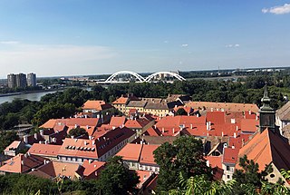
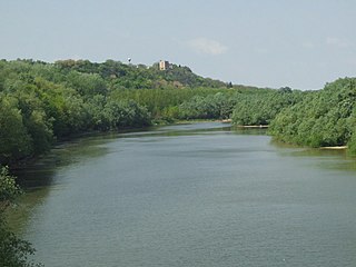
Petrovaradin is a historic town in the Serbian province of Vojvodina, now a part of the city of Novi Sad. As of 2011, the urban area has 14,810 inhabitants. Lying on the right bank of the Danube, across the main part of Novi Sad, it is built around the Petrovaradin Fortress, the historical anchor of the modern city.

<span class="mw-page-title-main">Bačka Palanka</span> Town and municipality in Vojvodina, Serbia

Bačka Palanka is a town and municipality located in the South Bačka District of the autonomous province of Vojvodina, Serbia. It is situated on the left bank of the Danube. In 2011 the town had a total population of 28,239, while Bačka Palanka municipality had 55,528 inhabitants.

<span class="mw-page-title-main">Inđija</span> Town and municipality in Vojvodina, Serbia

Inđija is a town and a municipality located in the Srem District of the autonomous province of Vojvodina, Serbia. As of 2024, the town has total population of 28,450, while the municipality has 47,433 inhabitants. It is located in the geographical region of Syrmia.

<span class="mw-page-title-main">Vukovar-Srijem County</span> County in eastern Croatia

Vukovar-Srijem County, Vukovar-Sirmium County or Vukovar-Syrmia County, named after the eponymous town of Vukovar and the region of Syrmia, is the easternmost Croatian county. It includes the eastern parts of the region of Slavonia and the western parts of the region of Syrmia, as well as the lower Sava river basin, Posavina and Danube river basin Podunavlje. Due to the overlapping definitions of geographic regions, division on Slavonia and Syrmia approximately divides the county vertically into north-west and south-east half, while division on Posavina and Podunavlje divides it horizontally on north-east and south-west half.

<span class="mw-page-title-main">Syrmia</span> Geographical region of Serbia and Croatia

Syrmia is a region of the southern Pannonian Plain, which lies between the Danube and Sava rivers. It is divided between Serbia and Croatia. Most of the region is flat, with the exception of the low Fruška gora mountain stretching along the Danube in its northern part.

<span class="mw-page-title-main">Syrmia County</span> Historic county of the Kingdom of Croatia-Slavonia

Syrmia County was a historic administrative subdivision (županija) of the Kingdom of Croatia-Slavonia. Croatia-Slavonia was an autonomous kingdom within the Lands of the Crown of Saint Stephen (Transleithania), the Hungarian part of Austria-Hungary. The region of Syrmia is today split between Croatia and Serbia. The capital of the county was Vukovar.

<span class="mw-page-title-main">Sremska Kamenica</span> Town in South Bačka, Serbia

Sremska Kamenica is a town and urban neighborhood of Novi Sad, in Serbia.

<span class="mw-page-title-main">Šid</span> Town and municipality in Vojvodina, Serbia

Šid is a town and municipality located in the Srem District of the autonomous province of Vojvodina, Serbia. It has a population of 14,893, while the municipality has 34,188 inhabitants. A border crossing between Serbia and Croatia is located in the town.

Podunavlje is the name of the Danube river basin parts located in Croatia and Serbia. Podunavlje is located on the southern edge of Pannonian Basin. In its wider meaning, the Croatian term refers to the area around the entire flow of the river Danube.

<span class="mw-page-title-main">Beočin</span> Town and municipality in Vojvodina, Serbia

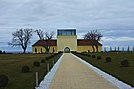
Beočin is a town and municipality located in the South Bačka District of the autonomous province of Vojvodina, Serbia. The population of the town is 7,839, whilst Beočin's municipality population is 15,726. There is also a Beočin Monastery from the 16th century in the municipality.

<span class="mw-page-title-main">Stara Pazova</span> Town and municipality in Vojvodina, Serbia

Stara Pazova is a town and municipality located in the Srem District of the autonomous province of Vojvodina, Serbia. The town has a population of 18,042, while Stara Pazova municipality has 65,792 inhabitants. The entrance into town from Inđija lies on 45th parallel north, it is half-way between the North pole and the equator.

<span class="mw-page-title-main">Pećinci</span> Village and municipality in Vojvodina, Serbia

Pećinci is a village and municipality located in the Srem District of the autonomous province of Vojvodina, Serbia. The village has a population of 2,581 (2011), while Pećinci municipality has 19,720 inhabitants.

Vojvodina is an autonomous province located in northern Serbia. It consists of the Pannonian Plain in the south, and the Danube and Sava rivers in the north.

<span class="mw-page-title-main">Erdut</span> Municipality in Slavonia, Croatia

Erdut is a village and a municipality in eastern Croatia some 37 km east of the major city of Osijek. Lying on the border with neighbouring Serbia, it was the site of the signing of the 1995 Erdut Agreement, which initiated the UNTAES transitional administration over the Eastern Slavonia, Baranja and Western Syrmia.

<span class="mw-page-title-main">Nova Pazova</span> Settlement in Vojvodina, Serbia

Nova Pazova is a settlement in Serbia. It is situated in the Stara Pazova municipality, in the region of Syrmia, in the autonomous province of Vojvodina. The settlement's population is currently 17,105.

<span class="mw-page-title-main">Hrtkovci</span> Village in Vojvodina, Serbia

Hrtkovci is a village located in the municipality of Ruma, Serbia. As of 2011 census, it has a population of 3,036 inhabitants.

<span class="mw-page-title-main">Donji Petrovci</span> Village in Vojvodina, Serbia

Donji Petrovci is a village in Serbia. It is situated in Ruma municipality, Srem District, Vojvodina province. The village has a Serb ethnic majority and a population of 991 people. There is a significant ancient Roman archaeological site near the village - the remains of large city Bassianae, which in the 3rd century had the highest status of colonia.

<span class="mw-page-title-main">Dobrinci</span> Village in Vojvodina, Serbia

Dobrinci is a village in Serbia. It is situated in the Ruma municipality, in the Srem District, Vojvodina province. The village has a Serb ethnic majority and its population numbering 1,716 people.

<span class="mw-page-title-main">Croatia–Serbia border dispute</span>

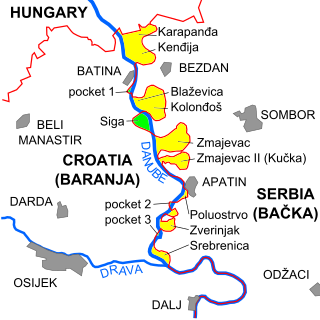
The border between Croatia and Serbia in the area of the Danube is disputed, an important part of their broader diplomatic relations. While Serbia claims that the thalweg of the Danube valley and the centerline of the river represents the international border between the two countries, Croatia disagrees, claiming that the international border lies along the boundaries of the cadastral municipalities located along the river—departing from the course at several points along a 140-kilometre (87 mi) section. The cadastre-based boundary reflects the course of the Danube which existed in the 19th century, before anti-meandering and hydrotechnical engineering works altered its course. The area size of the territory in dispute is reported variously, up to 140 km2.

References

  1. Register of spatial units of the State Geodetic Administration of the Republic of Croatia. Wikidata   Q119585703.
  2. "Population by Age and Sex, by Settlements, 2021 Census". Census of Population, Households and Dwellings in 2021. Zagreb: Croatian Bureau of Statistics. 2022.
  3. Dizdar, Marko (2016). "Late La Tène Settlements in the Vinkovci Region (Eastern Slavonia, Croatia): Centres of Trade and Exchange" (PDF). Boii - Taurisci: Proceedings of the International Seminar, Oberleis-Klement, June 14th-15th, 2012. Austrian Academy of Sciences Press: 31–48. Retrieved 22 January 2019.
  4. Lovrinčević, Željko; Davor, Mikulić; Budak, Jelena (June 2004). "AREAS OF SPECIAL STATE CONCERN IN CROATIA- REGIONAL DEVELOPMENT DIFFERENCES AND THE DEMOGRAPHIC AND EDUCATIONAL CHARACTERISTICS". Ekonomski pregled, Vol.55 No.5-6. Archived from the original on 18 August 2018. Retrieved 25 August 2018.
  5. "Population by Ethnicity, by Towns/Municipalities, 2011 Census: County of Vukovar-Sirmium". Census of Population, Households and Dwellings 2011. Zagreb: Croatian Bureau of Statistics. December 2012.
  6. 1 2 Book: "Ethnic and religious composition of population of Croatia, 1880-1991: by settlements", author: Jakov Gelo, publisher: Zagreb, Croatian bureau of statistics, 1998., ISBN   953-6667-07-X, ISBN   978-953-6667-07-9;
  7. Wertheimer-Baletić, Alica (1993). "JEDNO I POL STOLJEĆE U BROJČANOM RAZVOJU STANOVNIŠTVA VUKOVARA I VUKOVARSKOGA KRAJA". Društvena istraživanja: časopis za opća društvena pitanja. 2 (2–3): 455–477.
  8. 1 2 3 4 5 Boženka Dasovićová (3 July 2017). "Slováci v Iloku". Slovenský kultúrny klub v Srbsku. Retrieved 25 December 2022.
  9. 1 2 3 4 Boženka Čermáková (n.d.). "MATICA SLOVENSKÁ ILOK". Savez Slovaka. Retrieved 25 December 2022.
  10. "Ilok: Evangelička slovačka crkva". tvprofil.com. 2014. Retrieved 25 December 2022.
  11. "Manjinski izbori prve nedjelje u svibnju, kreću i edukacije". T-portal. 13 March 2023. Retrieved 2 May 2023.
  12. "Informacija o konačnim rezultatima izbora članova vijeća i izbora predstavnika nacionalnih manjina 2023. XVI. VUKOVARSKO-SRIJEMSKA ŽUPANIJA" (PDF) (in Croatian). Državno izborno povjerenstvo Republike Hrvatske. 2023. p. 7. Retrieved 3 June 2023.