Geography of Ukraine

Last updated
Geography of Ukraine
Wheat fields in Ukraine-5961.jpg
Wheat field in Ukraine
Ukraine relief location map.jpg
Continent Europe
Region Eastern Europe
Coordinates 50°27′N30°30′E / 50.450°N 30.500°E / 50.450; 30.500
Area Ranked 45th
  Total603,500 km2 (233,000 sq mi)
  Land96%
  Water4%
Coastline2,782 km (1,729 mi)
Borders4,558 km (2,832 mi)
Highest point Hoverla
2,061 metres (6,762 ft)
Lowest point Kuyalnik Estuary
−5 metres (−16 ft)
Longest river Dnieper
981 kilometres (610 mi)
Largest lake Lake Yalpuh
149 km2 (57.53 sq mi)
Exclusive economic zone147,318 km2 (56,880 sq mi)
The Carpathian National Park and Hoverla at 2,061 m (6,762 ft), the highest mountain in Ukraine Goverla z Kukula.jpg
The Carpathian National Park and Hoverla at 2,061 m (6,762 ft), the highest mountain in Ukraine

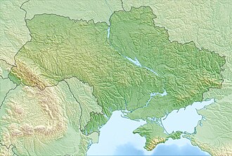
Ukraine is the second-largest European country, after Russia. Its various regions have diverse geographic features ranging from highlands to lowlands, as well as climatic range and a wide variety in hydrography. Most of the country lies within the East European Plain.

Contents

Lying between latitudes 44° and 53° N, and longitudes 22° and 41° E, Ukraine covers an area of 603,628 square kilometres (233,062 sq mi), with a coastline of 2,782 kilometres (1,729 mi). [1]

The landscape of Ukraine consists mostly of fertile steppes [2] and plateaus, crossed by rivers such as the Dnieper, Siverskyi Donets, Dniester and the Southern Bug as they flow south into the Black Sea and the smaller Sea of Azov. To the southwest, the delta of the Danube forms the border with Romania. The country's only mountains are the Carpathian Mountains in the west, of which the highest is Hoverla at 2,061 metres (6,762 ft), and the Crimean Mountains, in the extreme south along the coast. [3]

Ukraine also has a number of highland regions such as the Volyn-Podillia Upland (in the west) and the Near-Dnipro Upland (on the right bank of the Dnieper). To the east there are the south-western spurs of the Central Russian Upland, over which runs the border with the Russia. Near the Sea of Azov can be found the Donets Ridge and the Near Azov Upland. The snow melt from the mountains feeds the rivers and their waterfalls.

Significant natural resources in Ukraine include lithium, [4] natural gas, [5] kaolin, [5] timber [6] and an abundance of arable land. Despite this, the country faces a number of major environmental issues such as inadequate supplies of potable water, air and water pollution, deforestation, and radioactive contamination in the north-east from the 1986 accident at the Chernobyl Nuclear Power Plant.

Geographic location

Ukraine under russian occupation grey.svg
Red pog.svg
Kyiv
Red pog.svg
Chernihiv
Red pog.svg
Chernivtsi
Red pog.svg
Dnipro
Red pog.svg
Donetsk
Red pog.svg
Kharkiv
Red pog.svg
Lviv
Red pog.svg
Odesa
Red pog.svg
Sevastopol
Red pog.svg
Uzhhorod
Black Fire.svg
Mt. Hoverla
Red pog.svg
Simferopol
Red pog.svg
Ivano‑Frankivsk
Red pog.svg
Sumy
Red pog.svg
Sviatohirsk
Red pog.svg
Vinnytsia
Red pog.svg
Lutsk
Red pog.svg
Zaporizhzhia
Red pog.svg
Kryvyi Rih
Map of Ukraine

Ukraine is located in Eastern Europe: lying on the northern shores of the Black Sea and the Sea of Azov. The country borders Belarus in the north, Poland, Slovakia and Hungary in the west, Moldova and Romania in the south-west, and Russia in the east. [7]

The total geographic area of Ukraine is 603,700 square kilometers (233,100 sq mi). Ukraine has an Exclusive Economic Zone of 147,318 km2 (56,880 sq mi) in the Black Sea. [7]

The land border of Ukraine totals 6,993 kilometers (4,345 mi). [8] The border lengths with each country are: Belarus 891 kilometers (554 mi)[ failed verification ], Hungary 103 kilometers (64 mi)[ failed verification ], Moldova 939 kilometers (583 mi)[ failed verification ], Poland 428 kilometers (266 mi)[ failed verification ], Romania 169 kilometers (105 mi) on the south and 362 kilometers (225 mi) on the west[ failed verification ], Russia 1,974 kilometers (1,227 mi), and Slovakia 90 kilometers (56 mi)[ failed verification ]. Ukraine is also bordered by 3,783 kilometers (2,351 mi) of coastline[ failed verification ]. The border with Russia, part of which runs through the Sea of Azov, is the country's longest border. [9]

The village of Vel'ké Slemence is split between Slovakia and Ukraine. [10]

The largest mountain peaks

m above sea level :

Ukrainian Carpathians:

Hoverla 2060.8 m

Brebeneskul 2035.8 m

Black Mountain 2020.2 m

Petros 2020.2 m

Gutin Tomnatek 2016.4 m

Ribs 2001.1 m

The highest point in the plain part of the country is Mount Berda (515 m), the highest point in the left bank plain part is Mogila Mechetnaya (367.1 m).

Relief

Relief map of Ukraine Topographic map of Ukraine.svg
Relief map of Ukraine
Simplified depiction of the biomes lying north of the Black Sea. The bright green belt girdling the Black Sea's southern coast, extending westwards, denotes a region of subtropics. Pontic Caspian climate.png
Simplified depiction of the biomes lying north of the Black Sea. The bright green belt girdling the Black Sea's southern coast, extending westwards, denotes a region of subtropics.

Most of its territory lies within the Great European Plain, while parts of western regions and southern regions lay within the Alpine system. In general Ukraine comprises two different biomes: mixed forest towards the middle of the continent, and steppe towards the Black Sea littoral. Major provinces include, Polesian Lowland, Dnieper Lowland, Volhynia-Podolie Plateau, Black Sea-Azov Lowland, Donets-Azov Plateau, Central Russian Upland, Carpathians, and Pannonian Basin.

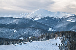
The western regions feature an alpine-like section of Carpathian Mountains, the Eastern Carpathians that stretches across Poland, Ukraine and Romania. The highest peak is Mount Hoverla, which at 2,061 meters (6,762 ft) above sea level is the highest point in the country. Mountains are limited to the west, the southern tip of Ukraine on the Sea of Azov. The western region has the Carpathian Mountains, and some eroded mountains from the Donets Ridge are in the east near the Sea of Azov.

Most of Ukraine's area is taken up by the steppe-like region just north of the Black Sea. Most of Ukraine consists of fertile plains (or steppes) and plateaus. In terms of land use, 58% of Ukraine is considered arable land; 2% is used for permanent crops, 13% for permanent pastures, 18% is forests and woodland, and 9% is other.

Physiographic division of Ukraine

Most of Ukraine consists of regular plains with the average height above sea level being 175 metres (574 ft). It is surrounded by mountains to its west and extreme south. Wide spaces of the country's plains are located in the south-western part of the East European Plain. The plains have numerous highlands and lowlands caused by the uneven crystallized base of the East European craton. The highlands are characterized by Precambrian basement rocks from the Ukrainian Shield.

Plains are considered elevations of no more than 0–600 m (0–1,969 ft) among which there are recognized lowlands (plains) and uplands (plateaus, ridges, hill ridges).

Great European Plain (subregion East European Plain)

Alpine system

Soil

Kinburn sandbar, Ochakiv Raion, Mykolaiv Oblast Kinburns'ka kosa voseni.jpg
Kinburn sandbar, Ochakiv Raion, Mykolaiv Oblast

From northwest to southeast the soils of Ukraine may be divided into three major aggregations: [11]

Agricultural works in Ivano-Frankivsk Oblast Polia pid Kasovoiu goroiu.jpg
Agricultural works in Ivano-Frankivsk Oblast

As much as two-thirds of the country's surface land consists of black earth, a resource that has made Ukraine one of the most fertile regions in the world and well known as a "breadbasket". [12] These soils may be divided into three broad groups:

Interspersed in various uplands and along the northern and western perimeters of the deep chernozems are mixtures of gray forest soils and podzolized black-earth soils, which together occupy much of Ukraine's remaining area. All these soils are very fertile when sufficient water is available. However, their intensive cultivation, especially on steep slopes, has led to widespread soil erosion and gullying.

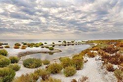
The smallest proportion of the soil cover consists of the chestnut soils of the southern and eastern regions. They become increasingly salinized to the south as they approach the Black Sea. [11]

Hydrography

Kalmius river, Donetsk Ranok na Kal'miusi.jpg
Kalmius river, Donetsk

The territory of Ukraine is bordered by the waters of the Black Sea and the Sea of Azov. More than 95% of the rivers are part of those two seas' drainage basins. A few rivers are part of the Baltic Sea basin. There are seven major rivers in Ukraine: Desna, Dnipro, Dnister, Danube, Prypiat, Siverian Donets, and Southern Buh. [13]

Climate

Ukraine map of Koppen climate classification. Koppen-Geiger Map UKR present.svg
Ukraine map of Köppen climate classification.
Average daily maximum and minimum temperatures for the seven largest cities in Ukraine [14]
LocationJuly (°C)July (°F)January (°C)January (°F)
Kyiv 27/1780/62-1/-631/22
Kharkiv 27/1781/62-2/-728/20
Dnipro 29/1784/63-1/-630/21
Odesa 28/1982/662/-336/27
Donetsk 27/1681/61-1/-629/20
Zaporizhzhia 28/1683/61-0/-531/21
Lviv 24/1375/56-1/-832/21
Visualisation of climate change in Kyiv, showing different temperature ranges between different 30-year time periods. Climate change in Kyiv over the last 120 years Temperature density function.png
Visualisation of climate change in Kyiv, showing different temperature ranges between different 30-year time periods.

Ukraine is firmly in the mid-latitudes, and generally has a continental climate, except for its southern coasts, which feature cold semi-arid and humid subtropical climates. [15] Average annual temperatures range from 5.5–7 °C (41.9–44.6 °F) in the north, to 11–13 °C (51.8–55.4 °F) in the south. [16] Precipitation is disproportionately distributed; it is highest in the west and north and lowest in the east and southeast. [16] Western Ukraine, particularly in the Carpathian Mountains, receives around 1,200 millimetres (47.2 in) of precipitation annually, while Crimea and the coastal areas of the Black Sea receive around 400 millimetres (15.7 in). [16]

Water availability from the major river basins is expected to decrease, especially in summer. This poses risks to the agricultural sector. [17] The negative impacts of climate change on agriculture are mostly felt in the south of the country, which has a steppe climate. In the north, some crops may be able to benefit from a longer growing season. [18] The World Bank has stated that Ukraine is highly vulnerable to climate change. [19]

Climate data for Kyiv (1991–2020, extremes 1881–present)
MonthJanFebMarAprMayJunJulAugSepOctNovDecYear
Record high °C (°F)13.2
(55.8)
17.3
(63.1)
22.4
(72.3)
30.2
(86.4)
33.6
(92.5)
35.5
(95.9)
39.4
(102.9)
39.3
(102.7)
35.7
(96.3)
27.9
(82.2)
23.2
(73.8)
15.2
(59.4)
39.4
(102.9)
Mean daily maximum °C (°F)−0.8
(30.6)
0.7
(33.3)
6.5
(43.7)
15.0
(59.0)
21.1
(70.0)
24.6
(76.3)
26.5
(79.7)
25.9
(78.6)
20.0
(68.0)
12.9
(55.2)
5.3
(41.5)
0.5
(32.9)
13.2
(55.8)
Daily mean °C (°F)−3.2
(26.2)
−2.3
(27.9)
2.5
(36.5)
10.0
(50.0)
15.8
(60.4)
19.5
(67.1)
21.3
(70.3)
20.5
(68.9)
14.9
(58.8)
8.6
(47.5)
2.6
(36.7)
−1.8
(28.8)
9.0
(48.2)
Mean daily minimum °C (°F)−5.5
(22.1)
−5.0
(23.0)
−0.8
(30.6)
5.7
(42.3)
10.9
(51.6)
14.8
(58.6)
16.7
(62.1)
15.7
(60.3)
10.6
(51.1)
5.1
(41.2)
0.4
(32.7)
−3.9
(25.0)
5.4
(41.7)
Record low °C (°F)−31.1
(−24.0)
−32.2
(−26.0)
−24.9
(−12.8)
−10.4
(13.3)
−2.4
(27.7)
2.5
(36.5)
5.8
(42.4)
3.3
(37.9)
−2.9
(26.8)
−17.8
(0.0)
−21.9
(−7.4)
−30.0
(−22.0)
−32.2
(−26.0)
Average precipitation mm (inches)38
(1.5)
40
(1.6)
40
(1.6)
42
(1.7)
65
(2.6)
73
(2.9)
68
(2.7)
56
(2.2)
57
(2.2)
46
(1.8)
46
(1.8)
47
(1.9)
618
(24.3)
Average extreme snow depth cm (inches)9
(3.5)
11
(4.3)
7
(2.8)
0
(0)
0
(0)
0
(0)
0
(0)
0
(0)
0
(0)
0
(0)
2
(0.8)
5
(2.0)
11
(4.3)
Average rainy days87913141514111412129138
Average snowy days17171020.20000.03291673
Average relative humidity (%)82.780.174.064.362.067.568.366.973.577.484.685.673.9
Mean monthly sunshine hours 426411216225727328725218912351311,843
Average ultraviolet index 1124676642113
Source 1: Pogoda.ru.net, [20] Central Observatory for Geophysics (extremes), [21] [22] World Meteorological Organization (humidity 1981–2010) [23]
Source 2: Danish Meteorological Institute (sun, 1931–1960) [24] and Weather Atlas [25]
Climate data for Kharkiv (1991−2020, extremes 1936–present)
MonthJanFebMarAprMayJunJulAugSepOctNovDecYear
Record high °C (°F)11.1
(52.0)
14.6
(58.3)
21.8
(71.2)
30.5
(86.9)
34.5
(94.1)
39.8
(103.6)
38.4
(101.1)
39.8
(103.6)
34.7
(94.5)
29.3
(84.7)
20.3
(68.5)
13.4
(56.1)
39.8
(103.6)
Mean daily maximum °C (°F)−2.1
(28.2)
−0.8
(30.6)
5.2
(41.4)
14.7
(58.5)
21.4
(70.5)
25.2
(77.4)
27.4
(81.3)
26.8
(80.2)
20.5
(68.9)
12.6
(54.7)
4.3
(39.7)
−0.7
(30.7)
12.9
(55.2)
Daily mean °C (°F)−4.5
(23.9)
−3.8
(25.2)
1.4
(34.5)
9.7
(49.5)
16.1
(61.0)
20.0
(68.0)
22.0
(71.6)
21.1
(70.0)
15.1
(59.2)
8.2
(46.8)
1.6
(34.9)
−2.9
(26.8)
8.7
(47.7)
Mean daily minimum °C (°F)−6.8
(19.8)
−6.6
(20.1)
−1.9
(28.6)
4.8
(40.6)
10.7
(51.3)
14.7
(58.5)
16.6
(61.9)
15.4
(59.7)
10.2
(50.4)
4.4
(39.9)
−0.8
(30.6)
−5.1
(22.8)
4.6
(40.3)
Record low °C (°F)−35.6
(−32.1)
−29.8
(−21.6)
−32.2
(−26.0)
−11.4
(11.5)
−1.9
(28.6)
2.2
(36.0)
5.7
(42.3)
2.2
(36.0)
−2.9
(26.8)
−9.1
(15.6)
−20.9
(−5.6)
−30.8
(−23.4)
−35.6
(−32.1)
Average precipitation mm (inches)37
(1.5)
33
(1.3)
36
(1.4)
32
(1.3)
54
(2.1)
58
(2.3)
63
(2.5)
39
(1.5)
44
(1.7)
44
(1.7)
39
(1.5)
40
(1.6)
519
(20.4)
Average extreme snow depth cm (inches)8
(3.1)
11
(4.3)
8
(3.1)
1
(0.4)
0
(0)
0
(0)
0
(0)
0
(0)
0
(0)
0
(0)
1
(0.4)
4
(1.6)
11
(4.3)
Average rainy days10810131415131012131312143
Average snowy days19181220.10000.03291880
Average relative humidity (%)85.683.077.365.760.965.265.362.970.277.685.786.573.8
Mean monthly sunshine hours 41.563.3123.5166.7252.9266.6278.0262.4176.6112.851.031.41,826.7
Source 1: Pogoda.ru.net [26]
Source 2: World Meteorological Organization (humidity and sun 1981–2010) [27]
Climate data for Dnipro (1991–2020, extremes 1948–present)
MonthJanFebMarAprMayJunJulAugSepOctNovDecYear
Record high °C (°F)12.3
(54.1)
17.5
(63.5)
24.1
(75.4)
31.8
(89.2)
36.1
(97.0)
37.8
(100.0)
39.8
(103.6)
40.9
(105.6)
36.5
(97.7)
32.6
(90.7)
20.6
(69.1)
13.7
(56.7)
40.9
(105.6)
Mean daily maximum °C (°F)−0.9
(30.4)
0.6
(33.1)
7.1
(44.8)
16.0
(60.8)
22.7
(72.9)
26.6
(79.9)
29.1
(84.4)
28.7
(83.7)
22.4
(72.3)
14.4
(57.9)
5.8
(42.4)
0.6
(33.1)
14.4
(57.9)
Daily mean °C (°F)−3.6
(25.5)
−2.8
(27.0)
2.5
(36.5)
10.3
(50.5)
16.5
(61.7)
20.5
(68.9)
22.7
(72.9)
22.1
(71.8)
16.2
(61.2)
9.2
(48.6)
2.6
(36.7)
−1.9
(28.6)
9.5
(49.1)
Mean daily minimum °C (°F)−6.1
(21.0)
−5.8
(21.6)
−1.2
(29.8)
5.1
(41.2)
10.9
(51.6)
15.1
(59.2)
17.1
(62.8)
16.3
(61.3)
11.0
(51.8)
5.2
(41.4)
−0.1
(31.8)
−4.2
(24.4)
5.3
(41.5)
Record low °C (°F)−30.0
(−22.0)
−27.8
(−18.0)
−19.2
(−2.6)
−8.0
(17.6)
−2.4
(27.7)
3.9
(39.0)
5.9
(42.6)
3.9
(39.0)
−3.0
(26.6)
−8.0
(17.6)
−17.9
(−0.2)
−27.8
(−18.0)
−30.0
(−22.0)
Average precipitation mm (inches)50
(2.0)
43
(1.7)
51
(2.0)
39
(1.5)
51
(2.0)
64
(2.5)
55
(2.2)
45
(1.8)
42
(1.7)
39
(1.5)
44
(1.7)
46
(1.8)
569
(22.4)
Average extreme snow depth cm (inches)7
(2.8)
10
(3.9)
5
(2.0)
0
(0)
0
(0)
0
(0)
0
(0)
0
(0)
0
(0)
0
(0)
1
(0.4)
4
(1.6)
10
(3.9)
Average rainy days981113131312910111211132
Average snowy days16159100000171564
Average relative humidity (%)87.784.679.266.862.266.264.762.469.577.286.588.374.6
Mean monthly sunshine hours 45.270.7126.3179.0264.9269.5299.0277.5197.3132.158.234.41,954.1
Source 1: Pogoda.ru.net [28]
Source 2: World Meteorological Organization (humidity and sun 1981–2010) [29]
Climate data for Odesa (1991–2020, extremes 1894–present)
MonthJanFebMarAprMayJunJulAugSepOctNovDecYear
Record high °C (°F)15.7
(60.3)
19.2
(66.6)
24.1
(75.4)
29.4
(84.9)
33.2
(91.8)
37.2
(99.0)
39.3
(102.7)
38.0
(100.4)
35.4
(95.7)
30.5
(86.9)
26.0
(78.8)
16.9
(62.4)
39.3
(102.7)
Mean daily maximum °C (°F)2.3
(36.1)
3.4
(38.1)
7.7
(45.9)
13.6
(56.5)
20.3
(68.5)
25.1
(77.2)
27.9
(82.2)
27.7
(81.9)
21.8
(71.2)
15.3
(59.5)
9.1
(48.4)
4.2
(39.6)
14.9
(58.8)
Daily mean °C (°F)−0.4
(31.3)
0.4
(32.7)
4.3
(39.7)
10.0
(50.0)
16.2
(61.2)
20.8
(69.4)
23.4
(74.1)
23.1
(73.6)
17.8
(64.0)
12.0
(53.6)
6.3
(43.3)
1.5
(34.7)
11.3
(52.3)
Mean daily minimum °C (°F)−2.7
(27.1)
−2.1
(28.2)
1.6
(34.9)
6.9
(44.4)
12.6
(54.7)
16.9
(62.4)
19.1
(66.4)
18.5
(65.3)
14.0
(57.2)
8.9
(48.0)
3.9
(39.0)
−0.8
(30.6)
8.1
(46.6)
Record low °C (°F)−26.2
(−15.2)
−28.0
(−18.4)
−16.0
(3.2)
−5.9
(21.4)
0.3
(32.5)
5.2
(41.4)
7.5
(45.5)
7.9
(46.2)
−0.8
(30.6)
−13.3
(8.1)
−14.6
(5.7)
−19.6
(−3.3)
−28.0
(−18.4)
Average precipitation mm (inches)43
(1.7)
35
(1.4)
35
(1.4)
28
(1.1)
39
(1.5)
47
(1.9)
45
(1.8)
40
(1.6)
44
(1.7)
37
(1.5)
39
(1.5)
38
(1.5)
470
(18.5)
Average extreme snow depth cm (inches)2
(0.8)
2
(0.8)
1
(0.4)
0
(0)
0
(0)
0
(0)
0
(0)
0
(0)
0
(0)
0
(0)
0
(0)
1
(0.4)
2
(0.8)
Average rainy days97101112131089101310122
Average snowy days111060.4000000.24941
Average relative humidity (%)82.580.778.474.571.070.666.065.471.877.181.983.675.3
Mean monthly sunshine hours 63.291.6142.2199.5292.5307.5332.9313.1234.6164.773.057.42,272.2
Source 1: Pogoda.ru [30]
Source 2: World Meteorological Organization (humidity and sun 1981–2010) [31]
Climate data for Yalta (1991–2020 normals, extremes 1948–present)
MonthJanFebMarAprMayJunJulAugSepOctNovDecYear
Record high °C (°F)17.8
(64.0)
20.2
(68.4)
27.8
(82.0)
28.5
(83.3)
33.0
(91.4)
35.0
(95.0)
39.1
(102.4)
39.1
(102.4)
33.2
(91.8)
31.5
(88.7)
25.2
(77.4)
22.0
(71.6)
39.1
(102.4)
Mean daily maximum °C (°F)7.4
(45.3)
7.7
(45.9)
10.4
(50.7)
14.8
(58.6)
20.5
(68.9)
25.7
(78.3)
29.1
(84.4)
29.4
(84.9)
24.2
(75.6)
18.3
(64.9)
12.8
(55.0)
8.9
(48.0)
17.4
(63.3)
Daily mean °C (°F)4.6
(40.3)
4.6
(40.3)
6.8
(44.2)
11.1
(52.0)
16.4
(61.5)
21.6
(70.9)
24.8
(76.6)
25.0
(77.0)
20.1
(68.2)
14.6
(58.3)
9.7
(49.5)
6.3
(43.3)
13.8
(56.8)
Mean daily minimum °C (°F)2.5
(36.5)
2.2
(36.0)
4.1
(39.4)
8.1
(46.6)
13.1
(55.6)
18.1
(64.6)
21.1
(70.0)
21.5
(70.7)
16.8
(62.2)
11.7
(53.1)
7.2
(45.0)
4.1
(39.4)
10.9
(51.6)
Record low °C (°F)−12.2
(10.0)
−12.3
(9.9)
−7.3
(18.9)
−3.8
(25.2)
2.8
(37.0)
7.8
(46.0)
12.4
(54.3)
10.0
(50.0)
3.9
(39.0)
−1.1
(30.0)
−8.9
(16.0)
−7.4
(18.7)
−12.3
(9.9)
Average precipitation mm (inches)76
(3.0)
56
(2.2)
48
(1.9)
29
(1.1)
36
(1.4)
35
(1.4)
32
(1.3)
43
(1.7)
43
(1.7)
52
(2.0)
57
(2.2)
84
(3.3)
591
(23.3)
Average extreme snow depth cm (inches)1
(0.4)
1
(0.4)
1
(0.4)
0
(0)
0
(0)
0
(0)
0
(0)
0
(0)
0
(0)
0
(0)
0
(0)
0
(0)
1
(0.4)
Average rainy days1412131211108710101215134
Average snowy days6640.20000001320
Average relative humidity (%)75.773.672.772.069.767.761.961.565.471.574.475.170.1
Mean monthly sunshine hours 68.685.1133.3174.9239.2273.2308.1280.6216.2145.189.363.22,076.8
Source 1: Pogoda.ru.net [32]
Source 2: World Meteorological Organization (humidity and sun 1981–2010) [33]

Natural resources

Significant natural resources in Ukraine include: iron ore, manganese, natural gas, [34] titanium, kaolin, uranium, and arable land. [5] [35]

Environmental issues

Ukraine has many environmental issues. [36] [37] Some regions lack adequate supplies of potable water. [38] Air and water pollution affects the country, as well as deforestation, and radiation contamination in the northeast stemming from the 1986 accident at the Chernobyl Nuclear Power Plant. [39]

See also

Related Research Articles

<span class="mw-page-title-main">Geography of Georgia (country)</span> Overview of the geography of Georgia

Georgia is a country in the Caucasus region, on the coast of the Black Sea. Sometimes considered a transcontinental country, it is located at the intersection of Eastern Europe and West Asia, and is today generally regarded as part of Europe. It is bordered to the north and northeast by Russia, to the south by Turkey and Armenia, and to the southeast by Azerbaijan.

<span class="mw-page-title-main">Geography of Laos</span>

Laos is a country in and the only landlocked nation in mainland Southeast Asia, northeast of Thailand and west of Vietnam. It covers approximately 236,800 square kilometers in the center of the Southeast Asian peninsula and it is surrounded by Myanmar (Burma), Cambodia, the People's Republic of China, Thailand, and Vietnam.

<span class="mw-page-title-main">Geography of Moldova</span> Geographical features of Moldova

Located in Eastern Europe, Moldova is bordered on the west and southwest by Romania and on the north, south, and east by Ukraine. Most of its territory lies in Bessarabia region, between the area's two main rivers, the Nistru and the Prut. The Nistru forms a small part of Moldova's border with Ukraine in the northeast and southeast, but it mainly flows through the eastern part of the country, separating Bessarabia and Transnistria. The Prut River forms Moldova's entire western boundary with Romania. The Danube touches the Moldovan border at its southernmost tip, and forms the border for 200 metres (656 ft).

<span class="mw-page-title-main">Geography of Morocco</span> Overview of the geography of Morocco

Morocco is the northwesternmost country which spans from the Mediterranean Sea and Atlantic Ocean on the north and the west respectively, into large mountainous areas in the interior, to the Sahara desert in the far south. Morocco is a Northern African country, located in the extreme northwest of Africa on the edge of continental Europe. The Strait of Gibraltar separates Spain from Morocco with a 13 kilometres (8.1 mi) span of water. Morocco borders the North Atlantic Ocean to the west, and the western Mediterranean Sea to the north, and has borders with Algeria and disputed Western Sahara.

<span class="mw-page-title-main">Geography of Romania</span> Overview of the geography of Romania

With an area of 238,397 km2 (92,046 sq mi), Romania is the twelfth-largest country in Europe. It is a Balkan country located at the crossroads of Eastern and Southeast Europe. It's bordered on the Black Sea, the country is halfway between the equator and the North Pole and equidistant from the westernmost part of Europe—the Atlantic Coast—and the most easterly—the Ural Mountains. Romania has 3,195 kilometres (1,985 mi) of border. Republic of Moldova and Ukraine lies to the east, Bulgaria lies to the south, and Serbia and Hungary to the west by the Pannonian Plain. In the southeast, 245 kilometres (152 mi) of sea coastline provide an important outlet to the Black Sea and the Atlantic Ocean.

<span class="mw-page-title-main">Geography of Russia</span>

Russia is the largest country in the world, covering over 17,125,192 km2 (6,612,074 sq mi), and encompassing more than one-eighth of Earth's inhabited land area. Russia extends across eleven time zones, and has the most borders of any country in the world, with sixteen sovereign nations.

<span class="mw-page-title-main">Tourism in Ukraine</span> Overview of tourism in Ukraine

Ukraine used to attract more than 20 million foreign citizens every year. But since 2014 this has lowered to about 10 million. Visitors primarily come from Eastern Europe, but also from Western Europe, as well as Turkey and Israel.

<span class="mw-page-title-main">Geography of the Soviet Union</span> Country in the past

The Soviet Union incorporated an area of over 22,402,200 square kilometres (8,649,500 sq mi), covering approximately one-sixth of Earth's land surface. It spanned most of Eurasia. Its largest and most populous republic was the Russian SFSR which covered roughly three-quarters of the surface area of the union, including the complete territory of contemporary Russia.

<span class="mw-page-title-main">East European Plain</span> Vast interior plain east of the North/Central European

The East European Plain is a vast interior plain extending east of the North European Plain, and comprising several plateaus stretching roughly from 25 degrees longitude eastward. It includes Volhynian-Podolian Upland on its westernmost fringe, the Central Russian Upland, and, on the eastern border, encompasses the Volga Upland. The plain includes also a series of major river basins such as the Dnepr Basin, the Oka–Don Lowland, and the Volga Basin. At the southeastern point of the East European Plain are the Caucasus and Crimean mountain ranges. Together with the North European Plain, and covering the Baltic states, European Russia, Belarus, Ukraine, Moldova, southeastern Romania, and, at its southernmost point, the Danubian Plain in Northern Bulgaria, it constitutes the majority of the Great European Plain, the greatest mountain-free part of the European landscape. The plain spans approximately 4,000,000 km2 (2,000,000 sq mi) and averages about 170 m (560 ft) in elevation. The highest point of the plain, located in the Valdai Hills, is 346.9 metres (1,138.1 ft).

<span class="mw-page-title-main">Geography of Europe</span>

Europe is traditionally defined as one of seven continents. Physiographically, it is the northwestern peninsula of the larger landmass known as Eurasia ; Asia occupies the centre and east of this continuous landmass. Europe's eastern frontier is usually delineated by the Ural Mountains in Russia, which is the largest country by land area in the continent. The southeast boundary with Asia is not universally defined, but the modern definition is generally the Ural River or, less commonly, the Emba River. The boundary continues to the Caspian Sea, the crest of the Caucasus Mountains, and on to the Black Sea. The Bosporus, the Sea of Marmara, and the Dardanelles conclude the Asian boundary. The Mediterranean Sea to the south separates Europe from Africa. The western boundary is the Atlantic Ocean. Iceland is usually included in Europe because it is over twice as close to mainland Europe as mainland North America. There is ongoing debate on where the geographical centre of Europe falls.

<span class="mw-page-title-main">Henichesk</span> Town in Kherson Oblast, Ukraine

Henichesk is a port city along the Sea of Azov in Kherson Oblast, southern Ukraine. It serves as the administrative centre of Henichesk Raion. Since 9 November 2022, it has served as the temporary administrative centre of the Russian occupation administration in the region. Henichesk also hosts the administration of Henichesk urban hromada, one of the hromadas of Ukraine. In January 2022, Henichesk had an estimated population of 18,889.

<span class="mw-page-title-main">Central Russian Upland</span> Upland region of the East European plain

The Central Russian Upland is an upland area of the East European Plain and is an undulating plateau with an average elevation of 230–250 m (750–820 ft). Its highest peak is measured at 293 m (961 ft). The southeastern portion of the upland known as the Kalach Upland. The Central Upland is built of Precambrian deposits of the crystalline Voronezh Massif.

<span class="mw-page-title-main">Climate of Armenia</span> Overview of the climate of Armenia

In Armenia, climates vary from cold desert and cold steppe on the lower parts of the Ararat plain, to tundra on mountain peaks, and a humid continental climate in the inner parts. The following six basic types can be distinguished. Another type of climate is the dry continental type. It prevails mostly along the middle reaches of the Arax up to an elevation of 1,300 m. It differs from the dry subtropical climate by its cold winters.

<span class="mw-page-title-main">European Plain</span> Largest mountain-free landform in Europe

The European Plain or the Great European Plain is a plain in Europe and is a major feature of one of four major topographical units of Europe - the Central and Interior Lowlands. It is the largest mountain-free landform in Europe, although a number of highlands are identified within it.

<span class="mw-page-title-main">Climate of Russia</span> Characteristics of the climate of Russia

The climate of Russia is formed under the influence of several determining factors. The enormous size of the country and the remoteness of many areas from the sea result in the dominance of the continental climate, which is prevalent in European and Asian Russia except for the tundra and the extreme southwest. Mountains in the south obstructing the flow of warm air masses from the Indian Ocean and the plain of the west and north makes the country open to Arctic and Atlantic influences.

<span class="mw-page-title-main">Geography of Poland</span> Geographical features of Poland

Poland is a country that extends across the North European Plain from the Sudetes and Carpathian Mountains in the south to the sandy beaches of the Baltic Sea in the north. Poland is the fifth-most populous country of the European Union and the ninth-largest country in Europe by area. The territory of Poland covers approximately 312,696 km2 (120,733 sq mi), of which 98.52% is land and 1.48% is water. The Polish coastline was estimated at 770 km (478 mi) in length. Poland's highest point is Rysy, at 2,500 m (8,202 ft).

Chornomorske or Chernomorskoye is an urban-type settlement and the administrative center of Chornomorske Raion in Crimea, a territory recognized by a majority of countries as part of Ukraine and occupied by Russia as the Republic of Crimea. It is located on the northern edge of the Tarkhankut Peninsula. Population: 11,267 ; 11,643.

<span class="mw-page-title-main">Black Sea Lowland</span> Part of the Eastern European Plain near the Black Sea

The Black Sea Lowland is a major geographic feature of the Northern Pontic region and the East European Plain. It is almost completely within Southern Ukraine covering half of its territory.

<span class="mw-page-title-main">Azov Upland</span> Plateau in Donetsk and Zaporizhia Oblasts, Ukraine

Azov Upland is a plateau or range of hills in East Ukraine within the Donetsk and Zaporizhia oblasts.

<span class="mw-page-title-main">Dnieper Lowland</span>

Dnieper Lowland is a major geographic feature of the Central Ukraine region and the East European Plain.

References

  1. "Ukraine". CIA World Factbook . 13 December 2007. Retrieved 24 December 2007.
  2. "Ukraine country profile". BBC News. 2022-03-01. Retrieved 2022-03-03.
  3. "Geographical location of Ukraine". www.ukrexport.gov.ua. Retrieved 2022-03-03.
  4. Tabuchi, Hiroko (2022-03-02). "Before Invasion, Ukraine's Lithium Wealth Was Drawing Global Attention". The New York Times. ISSN   0362-4331 . Retrieved 2022-03-03.
  5. 1 2 3 "Mining – UkraineInvest" . Retrieved 2022-03-03.
  6. Nature, Preferred by. "Ukraine Timber Risk Profile". NEPCon - Preferred by Nature. Retrieved 2022-03-03.
  7. 1 2 "Ukraine". The World Factbook. Central Intelligence Agency . Retrieved 1 March 2022.
  8. "Державна прикордонна служба України". www.pvu.gov.ua. Archived from the original on 6 December 2007. Retrieved 11 January 2022.
  9. "Agreement between the Russian Federation and the Ukraine on cooperation in the use of the sea of Azov and the strait of Kerch". www.ecolex.org. Retrieved 2018-11-27.
  10. Lyman, Rick (2015-08-10). "A Ukrainian Border Town Once Fenced by Soviets Blossoms Into a Shopper's Paradise". The New York Times. ISSN   0362-4331 . Retrieved 2022-03-03.
  11. 1 2 "Ukraine". Encyclopædia Britannica.
  12. Magocsi, Paul R. A history of Ukraine: The land and its peoples. University of Toronto Press, 2010.
  13. "Seas, Rivers and Lakes of Ukraine".
  14. "Ukraine climate information". Weatherbase. Retrieved February 2, 2016.
  15. "Ukraine". Country Pasture/Forage Resource Profiles. Food and Agriculture Organization. Retrieved 8 August 2016.
  16. 1 2 3 "Ukraine – Climate". Encyclopædia Britannica. Retrieved 20 October 2015.
  17. Didovets, Iulii; Krysanova, Valentina; Hattermann, Fred Fokko; del Rocío Rivas López, María; Snizhko, Sergiy; Müller Schmied, Hannes (2020-12-01). "Climate change impact on water availability of main river basins in Ukraine" (PDF). Journal of Hydrology: Regional Studies. 32: 100761. doi: 10.1016/j.ejrh.2020.100761 . ISSN   2214-5818. S2CID   230613418.
  18. Skrypnyk, Andriy; Zhemoyda, Oleksandr; Klymenko, Nataliia; Galaieva, Liudmyla; Koval, Tatiana (2021-03-01). "Econometric Analysis of the Impact of Climate Change on the Sustainability of Agricultural Production in Ukraine". Journal of Ecological Engineering. 22 (3): 275–288. doi: 10.12911/22998993/132945 . ISSN   2299-8993. S2CID   233801987.
  19. "World Bank Climate Change Knowledge Portal". climateknowledgeportal.worldbank.org.
  20. "Weather and Climate – The Climate of Kyiv" (in Russian). Weather and Climate (Погода и климат). Archived from the original on 13 December 2019. Retrieved 8 November 2021.
  21. "ЦГО Кліматичні дані по м.Києву". cgo-sreznevskyi.kyiv.ua (in Ukrainian). Central Observatory for Geophysics. Archived from the original on 18 April 2020. Retrieved 12 October 2020.
  22. "ЦГО Кліматичні рекорди". cgo-sreznevskyi.kyiv.ua (in Ukrainian). Central Observatory for Geophysics. Archived from the original on 31 March 2020. Retrieved 12 October 2020.
  23. "World Meteorological Organization Climate Normals for 1981–2010". World Meteorological Organization. Archived from the original on 17 July 2021. Retrieved 17 July 2021.
  24. Cappelen, John; Jensen, Jens. "Ukraine – Kyiv" (PDF). Climate Data for Selected Stations (1931–1960) (in Danish). Danish Meteorological Institute. p. 332. Archived from the original (PDF) on 27 April 2013. Retrieved 1 April 2016.
  25. "Kiev, Ukraine - Detailed climate information and monthly weather forecast". Weather Atlas. Yu Media Group. Archived from the original on 3 July 2019. Retrieved 3 July 2019.
  26. "Weather and Climate - The Climate of Kharkiv" (in Russian). Weather and Climate (Погода и климат). Archived from the original on 13 December 2019. Retrieved 8 November 2021.
  27. "World Meteorological Organization Climate Normals for 1981–2010". World Meteorological Organization. Archived from the original on 17 July 2021. Retrieved 18 July 2021.
  28. "Климат Днепра (Climate of Dnipro)" (in Russian). Pogoda.ru.net. 2016. Archived from the original on 13 December 2019. Retrieved 8 November 2021.
  29. "World Meteorological Organization Climate Normals for 1981–2010". World Meteorological Organization. Archived from the original on 17 July 2021. Retrieved 18 July 2021.
  30. Погода и Климат – Климат Одессы [Weather and Climate – The Climate of Odesa] (in Russian). Weather and Climate (Погода и климат). Retrieved 8 November 2021.
  31. "World Meteorological Organization Climate Normals for 1981–2010". World Meteorological Organization. Archived from the original on 17 July 2021. Retrieved 17 July 2021.
  32. "Климат Ялты" (in Russian). Погода и климат (Weather and Climate). Archived from the original on 14 December 2019. Retrieved 8 November 2021.
  33. "World Meteorological Organization Climate Normals for 1981–2010". World Meteorological Organization. Archived from the original on 17 July 2021. Retrieved 18 July 2021.
  34. "The Forgotten Potential of Ukraine's Energy Reserves". Harvard International Review. 2020-10-10. Retrieved 2022-03-03.
  35. "How Ukraine war will impact its farming – agronomist's view". Farmers Weekly. 2022-02-28. Retrieved 2022-03-03.
  36. "Ukraine invasion: rapid overview of environmental issues". CEOBS. 2022-02-25. Retrieved 2022-03-03.
  37. "Ukraine Country Environmental Analysis". World Bank . January 2016.
  38. "Water, sanitation and hygiene (WASH)". www.unicef.org. Retrieved 2022-03-03.
  39. "Environmental issues in Ukraine". Naturvernforbundet. 16 July 2017.

Notes