Geography of Denmark

Last updated
Geography of Denmark
Satellite image of Denmark in July 2001.jpg
Continent Europe
Region Northern Europe (Scandinavia)
Coordinates 56°00′N10°00′E / 56.000°N 10.000°E / 56.000; 10.000
Area
  Total43,094 km2 (16,639 sq mi)
  Land98%
  Water2%
Coastline8,750 km (5,440 mi)
Borders Total land borders:
68 km
Highest point Møllehøj
171 m
Lowest point Lammefjord
-7 m
Longest river Gudenå
149 km
Largest lake Arresø
40.72 km2
Exclusive economic zone105,989 km2 (40,923 sq mi) (excludes the Faroe Islands and Greenland)

Denmark is a Nordic country located in Northern Europe. It consists of the Jutland Peninsula and several islands in the Baltic Sea, referred[ citation needed ] to as the Danish Archipelago. Denmark is located southwest of Sweden and due south of Norway and is bordered by the German state (and former possession) Schleswig-Holstein to the south, on Denmark's only land border, 68 kilometres (42 miles) long.

Contents

Denmark borders both the Baltic and North seas along its 8,750 km (5,440 mi) tidal shoreline. Denmark's general coastline is much shorter, at 1,701 km (1,057 mi), as it would not include most of the 1,419 offshore islands (each defined as exceeding 100 square metres in area) and the 180-kilometre long Limfjorden, which separates Denmark's second largest island, North Jutlandic Island, 4,686 km2 in size, from the rest of Jutland. No location in Denmark is further from the coast than 52 km (32 mi). The land area of Denmark is estimated to be 43,094 km2 (16,639 sq mi). However, it cannot be stated exactly since the ocean constantly erodes and adds material to the coastline, and there are human land reclamation projects. On the southwest coast of Jutland, the tide is between 1 and 2 m (3.28 and 6.56 ft), and the tideline moves outward and inward on a 10 km (6.2 mi) stretch. [1] A recent global remote sensing analysis suggested that there were 607 km2 of tidal flats in Denmark, making it the 42nd ranked country in terms of tidal flat extent. [2] Denmark has an Exclusive Economic Zone of 105,989 km2 (40,923 sq mi). When including the Faroe Islands and Greenland, the EEZ is the 15th largest in the world with 2,220,093 km2 (857,183 sq mi).

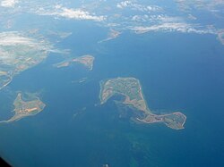
A circle enclosing the same total area as Denmark would have a diameter of 234 km (146 miles). Denmark has 443 named islands (1,419 islands above 100 m2), [3] of which 72 are inhabited (as of 1 January 2007, Statistics Denmark). The largest islands are Zealand (Sjælland) and Funen (Fyn). The island of Bornholm is located east of the rest of the country, in the Baltic Sea. Many of the larger islands are connected by bridges; the Øresund Bridge connects Zealand with Sweden; the Great Belt Bridge connects Funen with Zealand; and the Little Belt Bridge connects Jutland with Funen. Ferries or small aircraft connect to the smaller islands. Main cities are the capital Copenhagen on Zealand; Århus, Aalborg and Esbjerg in Jutland; and Odense on Funen.

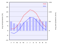
Denmark experiences a temperate climate, with mild, windy winters and cool summers. The local terrain is generally flat with a few gently rolling plains. The territory of Denmark includes the island of Bornholm in the Baltic Sea and the rest of metropolitan Denmark, but excludes the Faroe Islands and Greenland. Its position gives Denmark complete control of the Danish Straits (Skagerrak and Kattegat) linking the Baltic and North Seas. The country's natural resources include petroleum, natural gas, fish, salt, limestone, chalk, stone, gravel, and sand.

Environment

Denmark is highly urbanised. Here Greater Copenhagen in the capital region. Vor Frelsers Kirke-view10.jpg
Denmark is highly urbanised. Here Greater Copenhagen in the capital region.
The Danish landscape is characterised by flat, arable land and sandy coasts. Kattegat coast of Skagen.jpg
The Danish landscape is characterised by flat, arable land and sandy coasts.
Beech is a common tree throughout Denmark's sparse woodlands. Maj i Riis Skov 04.JPG
Beech is a common tree throughout Denmark's sparse woodlands.

Climate

Climate data for Denmark (2001–2010)
MonthJanFebMarAprMayJunJulAugSepOctNovDecYear
Mean daily maximum °C (°F)3.3
(37.9)
3.3
(37.9)
6.1
(43.0)
11.5
(52.7)
15.5
(59.9)
18.5
(65.3)
21.6
(70.9)
21.2
(70.2)
17.5
(63.5)
12.3
(54.1)
7.9
(46.2)
4.2
(39.6)
11.9
(53.4)
Daily mean °C (°F)1.5
(34.7)
1.2
(34.2)
3.0
(37.4)
7.5
(45.5)
11.4
(52.5)
14.6
(58.3)
17.4
(63.3)
17.2
(63.0)
13.8
(56.8)
9.4
(48.9)
5.7
(42.3)
2.2
(36.0)
8.8
(47.8)
Mean daily minimum °C (°F)−0.8
(30.6)
−1.3
(29.7)
−0.2
(31.6)
3.6
(38.5)
7.4
(45.3)
10.6
(51.1)
13.4
(56.1)
13.5
(56.3)
10.2
(50.4)
6.2
(43.2)
3.2
(37.8)
−0.3
(31.5)
5.5
(41.9)
Average precipitation mm (inches)66
(2.6)
50
(2.0)
43
(1.7)
37
(1.5)
53
(2.1)
68
(2.7)
77
(3.0)
91
(3.6)
62
(2.4)
83
(3.3)
75
(3.0)
61
(2.4)
765
(30.1)
Average rainy days (≥ 1 millimetre (0.039 in))181513111313141614172017181
Mean monthly sunshine hours 477114619823523923219616211158451,739
Source: Danmarks Meteorologiske Institut
Climate data for Denmark (extremes, most 1961-1990)
MonthJanFebMarAprMayJunJulAugSepOctNovDecYear
Record high °C (°F)11.8
(53.2)
15.8
(60.4)
22.2
(72.0)
26.2
(79.2)
31.0
(87.8)
35.9
(96.6)
35.9
(96.6)
36.4
(97.5)
29.8
(85.6)
24.0
(75.2)
19.6
(67.3)
13.0
(55.4)
36.4
(97.5)
Record low °C (°F)−31.2
(−24.2)
−29.0
(−20.2)
−27.0
(−16.6)
−12.1
(10.2)
−6.0
(21.2)
−1.6
(29.1)
1.0
(33.8)
−0.1
(31.8)
−4.4
(24.1)
−9.0
(15.8)
−19.0
(−2.2)
−25.6
(−14.1)
−31.2
(−24.2)
[ citation needed ]

Land use

Arable land: 55.99% Permanent crops: 0.14% Other: 42.87% (2012)

Irrigated land: 4,354 km2 (2007)

Total renewable water resources: 6 km3 (2011)

Freshwater withdrawal (domestic/industrial/agricultural):
total: 0.66 km3/yr (58%/5%/36%)
per capita: 118.4 m3/yr (2009)

Land reclamation

In 2019, the government proposed building 9 new artificial islands, named project Holmene, which would create 3 km2 of reclaimed land, to be built from 2022 to 2040. [4]

In June 2021, lawmakers approved the construction of a 3 km2 island, named Lynetteholm, in the Copenhagen Harbor. [5] A spokesperson for the Climate Movement in Denmark (Klimabevægelsen i Danmark) said the organization would sue the government over environmental concerns. [6]

Agriculture

Denmark has plenty of rain, flat landscape, and moderate climate. With 55.99% of its land considered as arable, Denmark has model characteristics for agriculture. 61% of the country's total area is cultivated [7] Farms in Denmark are remarkably large, averaging 172.9 acres per farm. Additionally, homesteads exceeding 247 acres make up more than 20% in Denmark. Many of these large farms harvest fruits and vegetables, the leading exports from Denmark are meat, fur, and dairy products. [7] The animal's diets in Denmark consist of mainly cereals since they are the dominant field crop. 75% of all cereal produced in Denmark is feed to the four most produced animals which are pigs, cattle, chicken and mink. [7] Denmark overproduces about 66% of food production compared to their own population size (5.7 million) being that they are able to feed 15 million people. This is a byproduct of being highly productive within the Danish agricultural production. [7]

In 1961, Denmark's Agricultural land represented 74.5% of land area. Fifty-six years later to 2015, Denmark has decreased its amount of Agricultural land down to 62.1% [8] then to 61% one year later in reference to "Facts and Figures - Danish Agriculture and Food" [7] The decrease in agricultural land comes as farmers are being well educated and the intensive amount of research and development is being implemented. It begins with advancements in agro-technology. The results have improved fertilization and nutrient use on arable land. Digestibility and nutrient uptake are developing from the improvements of new methods that are being implemented. Examples of these new methods are the addition of enzymes and microbial cultures. [7]

Natural hazards

  • Flooding is a threat in some areas of the country

Current issues

  • Air pollution, principally from vehicle and power plant emissions
  • Nitrogen and phosphorus pollution of the North Sea
  • Drinking and surface water becoming polluted from animal wastes and pesticides. Drinking water is very safe to drink, even though Denmark, unlike most countries, has almost no cleaning of drinking water

International agreements

  • Party to: Air Pollution, Air Pollution-Nitrogen Oxides,
    Air Pollution-Sulphur 85, Air Pollution-Sulphur 94, Air Pollution-Volatile Organic Compounds, Antarctic Treaty, Biodiversity, Climate Change, Desertification, Endangered Species, Environmental Modification, Hazardous Wastes, Law of the Sea, Marine Dumping, Marine Life Conservation, Nuclear Test Ban, Ozone Layer Protection, Ship Pollution, Tropical Timber 83, Tropical Timber 94, Wetlands, Whaling
  • Signed, but not ratified: Air Pollution-Persistent Organic Pollutants, Antarctic-Environmental Protocol, Climate Change-Kyoto Protocol

Transnational issues

Maritime claims

Map showing the location of Denmark including the Faroe Islands and Greenland (pdf), collectively known as the Danish Realm. Arctic.svg
Map showing the location of Denmark including the Faroe Islands and Greenland (pdf), collectively known as the Danish Realm.
  • Contiguous zone:24  nmi (44.4 km; 27.6 mi)
  • Continental shelf: 200-m depth or to the depth of exploitation
  • Exclusive economic zone:105,989 km2 (40,923 sq mi) (excludes Greenland and Faroe Islands). 200 nmi (370.4 km; 230.2 mi)
  • Territorial sea:12 nmi (22.2 km; 13.8 mi)

Other issues

  • Iceland disputes the Faroe Islands' fisheries median line.
  • Iceland, Ireland and the United Kingdom dispute Denmark's claim that the Faroe Islands' continental shelf extends beyond 200 nautical miles or about 370 km.
  • The Faroe Islands continue to study proposals for full independence.
  • Denmark is currently investigating the extent of the continental shelf of Greenland, in the hope that Greenland's Exclusive Economic Zone can be expanded. One of the areas investigated is the geographical North Pole.

Population

Urban population

See also

Notes

Footnotes

  1. Nationalencyklopedin, (1990)
  2. Murray, N.J.; Phinn, S.R.; DeWitt, M.; Ferrari, R.; Johnston, R.; Lyons, M.B.; Clinton, N.; Thau, D.; Fuller, R.A. (2019). "The global distribution and trajectory of tidal flats". Nature. 565 (7738): 222–225. doi:10.1038/s41586-018-0805-8. PMID   30568300. S2CID   256767470.
  3. Islands in total and named islands [ permanent dead link ]
  4. "Denmark embarks on ambitious plan to create new islands off Copenhagen coast". New Atlas. 2019-01-11. Retrieved 2021-06-23.
  5. "Danish Parliament approves controversial artificial island to protect Copenhagen from rising seas". The Architect’s Newspaper. 2021-06-22. Retrieved 2021-06-23.
  6. Walsh, David (2021-06-04). "Danish government facing lawsuit over 'green' artificial island". euronews. Retrieved 2021-06-23.
  7. 1 2 3 4 5 6 "FACTS AND FIGURES: Danish Agriculture and Food".
  8. "Agricultural land (% of land area) | Data". data.worldbank.org. Retrieved 2018-11-29.
  9. "The World Factbook — Central Intelligence Agency". www.cia.gov. Retrieved 2018-10-12.
  10. "Denmark Population 2018 (Demographics, Maps, Graphs)". worldpopulationreview.com. Retrieved 2018-10-12.
  11. "A brief history of Copenhagen". VisitDenmark (in Lingala). Retrieved 2018-10-31.
  12. "Copenhagen Population 2020". worldpopulationreview.com. Retrieved 2019-01-25.

Related Research Articles

<span class="mw-page-title-main">Transport in Denmark</span>

Transport in Denmark is developed and modern. The motorway network covers 1,111 km while the railway network totals 2,667 km of operational track. The Great Belt Fixed Link connecting the islands of Zealand and Funen and the New Little Belt Bridge connecting Funen and Jutland greatly improved the traffic flow across the country on both motorways and rail. The two largest airports of Copenhagen and Billund provide a variety of domestic and international connections, while ferries provide services to the Faroe Islands, Greenland, Iceland, Germany, Sweden, and Norway, as well as domestic routes servicing most Danish islands.

<span class="mw-page-title-main">Geography of Estonia</span> Overview of the geography of Estonia

Between 57.3 and 59.5 latitude and 21.5 and 28.1 longitude, Estonia lies on the eastern coast of the Baltic Sea on the level northwestern part of the rising East European Platform. Estonia's continental mainland is bordered to the north by the Gulf of Finland across from Finland, to the east by Lake Peipus and Russia, and to the south by Latvia. Besides the part of the European continent, Estonian territory also includes the larger islands of Saaremaa and Hiiumaa, and over 2,200 other islands and islets in the Baltic Sea, off the western and northern shores of the country's mainland.

<span class="mw-page-title-main">Geography of the Faroe Islands</span>

The Faroe Islands are an island group consisting of eighteen islands between the Norwegian Sea and the North Atlantic, about half-way between Iceland and Norway. Its coordinates are 62°N7°W. It is 1,393 square kilometres in area, and includes small lakes and rivers, but no major ones. There are 1,117 kilometres of coastline, and no land boundaries with any other country.

<span class="mw-page-title-main">Geography of Indonesia</span> Geography of the country of Indonesia

Indonesia is an archipelagic country located in Southeast Asia and Oceania, lying between the Indian Ocean and the Pacific Ocean. It is located in a strategic location astride or along major sea lanes connecting East Asia, South Asia and Oceania. Indonesia is the largest archipelago in the world. Indonesia's various regional cultures have been shaped—although not specifically determined—by centuries of complex interactions with its physical environment.

<span class="mw-page-title-main">Geography of Latvia</span> Geographical features of Latvia

Latvia lies on the eastern shores of the Baltic Sea on the level northwestern part of the rising East European platform, between Estonia and Lithuania. About 98% of the country lies under 200 m (656 ft) elevation. With the exception of the coastal plains, the ice age divided Latvia into three main regions: the morainic Western and Eastern uplands and the Middle lowlands. Latvia holds over 12,000 rivers, only 17 of which are longer than 100 km (60 mi), and over 3,000 small lakes, most of which are eutrophic. The major rivers include the Daugava, the Lielupe, the Gauja, the Venta and the Salaca. Woodlands cover around 52% of the country. Other than peat, dolomite, and limestone, natural resources are scarce. Latvia has 504 km (313 mi) of sandy coastline, and the ports of Liepāja and Ventspils provide important warm-water harbors for the Baltic coast.

<span class="mw-page-title-main">Geography of Lithuania</span>

Lithuania is a country in the Baltic region of Europe. The most populous of the Baltic states, Lithuania has 262 km (163 mi) of coastline consisting of the continental coast and the "Curonian Spit" coast. Lithuania's major warm-water port of Klaipėda lies at the narrow mouth of Curonian Lagoon, a shallow lagoon extending south to Kaliningrad and separated from the Baltic sea by Curonian Spit, where Kuršių Nerija National Park was established for its remarkable sand dunes.

<span class="mw-page-title-main">Geography of Suriname</span>

Suriname is located in the northern part of South America and is part of Caribbean South America, bordering the North Atlantic Ocean, between French Guiana and Guyana. It is mostly covered by tropical rainforest, containing a great diversity of flora and fauna that, for the most part, are increasingly threatened by new development. There is a relatively small population, most of which live along the coast.

<span class="mw-page-title-main">Geography of Thailand</span>

Thailand is in the middle of mainland Southeast Asia. It has a total size of 513,120 km2 (198,120 sq mi) which is the 50th largest in the world. The land border is 4,863 km (3,022 mi) long with Myanmar, Cambodia, Laos and Malaysia. The nation's axial position influenced many aspects of Thailand's society and culture. It controls the only land route from Asia to Malaysia and Singapore. It has an exclusive economic zone of 299,397 km2 (115,598 sq mi).

<span class="mw-page-title-main">Geography of the United Kingdom</span>

The United Kingdom is a sovereign state located off the north-western coast of continental Europe. With a total area of approximately 248,532 square kilometres (95,960 sq mi), the UK occupies the major part of the British Isles archipelago and includes the island of Great Britain, the north-eastern one-sixth of the island of Ireland and many smaller surrounding islands. It is the world's 7th largest island country. The mainland areas lie between latitudes 49°N and 59°N, and longitudes 8°W to 2°E. The Royal Observatory, Greenwich, in south-east London, is the defining point of the Prime Meridian.

<span class="mw-page-title-main">Geography of Vietnam</span> Geographical features of Vietnam

Vietnam is located on the eastern margin of the Indochinese peninsula and occupies about 331,211.6 square kilometres (127,881.5 sq mi), of which about 25% was under cultivation in 1987. It borders the Gulf of Tonkin, Gulf of Thailand, and Pacific Ocean, along with China, Laos, and Cambodia. The elongated roughly S shaped country has a north-to-south distance of 1,650 km (1,030 mi) and is about 50 km (31 mi) wide at the narrowest point. With a coastline of 3,260 km (2,030 mi), excluding islands, Vietnam claims 12 nautical miles as the limit of its territorial waters, an additional 12 nautical miles as a contiguous customs and security zone. It has an exclusive economic zone of 417,663 km2 (161,261 sq mi) with 200 nautical miles.

<span class="mw-page-title-main">Geography of the Netherlands</span> Overview of the geography of the European Netherlands

The geography of the European Netherlands is unusual in that much of its land has been reclaimed from the sea and is below sea level, protected by dikes. It is a small country with a total area of 41,545 km2 (16,041 sq mi) and ranked 131st. With a population of 17.4 million and density of 521/km2 (1,350/sq mi) makes it the second most densely populated member of the European Union after Malta, and the 12th most densely populated country in the world, behind only three countries with a population over 16 million. Consequently, the Netherlands is highly urbanized.

<span class="mw-page-title-main">Geography of Iceland</span> Geographical features of Iceland

Iceland is an island country at the confluence of the North Atlantic and Arctic oceans, east of Greenland and immediately south of the Arctic Circle, atop the constructive boundary of the northern Mid-Atlantic Ridge. The island country is the world's 18th largest in area and one of the most sparsely populated. It is the westernmost European country when not including Greenland and has more land covered by glaciers than continental Europe. Its total size is 103,125 km2 (39,817 sq mi) and possesses an exclusive economic zone of 751,345 km2 (290,096 sq mi).

<span class="mw-page-title-main">Geography of Bangladesh</span> Geography of Bangladesh

Bangladesh is a densely populated, low-lying, mainly riverine country located in South Asia with a coastline of 580 km (360 mi) on the northern littoral of the Bay of Bengal. The delta plain of the Ganges (Padma), Brahmaputra (Jamuna), and Meghna Rivers and their tributaries occupy 79 percent of the country. Four uplifted blocks occupy 9 percent and steep hill ranges up to approximately 1,000 metres (3,300 ft) high occupy 12 percent in the southeast and in the northeast. Straddling the Tropic of Cancer, Bangladesh has a tropical monsoon climate characterised by heavy seasonal rainfall, high temperatures, and high humidity. Natural disasters such as floods and cyclones accompanied by storm surges periodically affect the country. Most of the country is intensively farmed, with rice the main crop, grown in three seasons. Rapid urbanisation is taking place with associated industrial and commercial development. Exports of garments and shrimp plus remittances from Bangladeshis working abroad provide the country's three main sources of foreign exchange income.

<span class="mw-page-title-main">Denmark</span> Country in Northern Europe

Denmark is a Nordic country in the south-central portion of Northern Europe. It is the metropolitan part of and the most populous constituent of the Kingdom of Denmark, a constitutionally unitary state that includes the autonomous territories of the Faroe Islands and Greenland in the North Atlantic Ocean. Metropolitan Denmark is the southernmost of the Scandinavian countries, lying south-west and south of Sweden, south of Norway, and north of Germany, with which it shares a short border, Denmark's only land border.

<span class="mw-page-title-main">Regions of Denmark</span> Administrative territorial entity of Denmark

The five Regions of Denmark were created as administrative entities at a level above the municipalities and below the central government in the public sector as part of the 2007 Danish Municipal Reform, when the 13 counties (amter) were abolished. At the same time, the number of municipalities (kommuner) was cut from 270 to 98. The reform was approved and made into a law by the lawmakers in the Folketing 26 June 2005 with elections to the 98 municipalities and 5 regions being held Tuesday 15 November 2005.

<span class="mw-page-title-main">Outline of Denmark</span> Overview of and topical guide to Denmark

The following outline is provided as an overview, and topical guide to Denmark.

<span class="mw-page-title-main">Geography of Germany</span>

Germany is a country in Central and Western Europe that stretches from the Alps, across the North European Plain to the North Sea and the Baltic Sea. It is the second-most populous country in Europe after Russia, and is seventh-largest country by area in the continent. The area of Germany ranked 63rd and covers 357,021 km2 (137,847 sq mi), consisting of 349,223 km2 (134,836 sq mi) of land and 7,798 km2 (3,011 sq mi) of waters, smaller than Japan but larger than Republic of the Congo.

<span class="mw-page-title-main">Borders of Denmark</span> Overview of the borders of the Kingdom of Denmark

The Kingdom of Denmark has existed with its current territory since 1920, although the last territorial dispute with Canada was only settled on June 14, 2022. The only land border of Denmark (proper) is that with Germany, with a length of 68 km (42 mi). Greenland, an autonomous country of the Danish Realm, also shares a border with Canada splitting Hans Island in half in which the border is 1.28 km long. The border along the territorial waters with Sweden runs along the Øresund for a length of about 115 km (71 mi).

References

The World Book Encyclopedia (2003 ed.). 1974. ISBN   0716601036.

Commons-logo.svg Media related to Geography of Denmark at Wikimedia Commons