Geography of Liechtenstein

Last updated

Map of the Principality of Liechtenstein Ls-map.png
Map of the Principality of Liechtenstein
Satellite image of Liechtenstein area, with the border shown in yellow Lichtenstein NASA.png
Satellite image of Liechtenstein area, with the border shown in yellow
Enlargeable, detailed map of Liechtenstein Liechtenstein2021OSMenglish.png
Enlargeable, detailed map of Liechtenstein

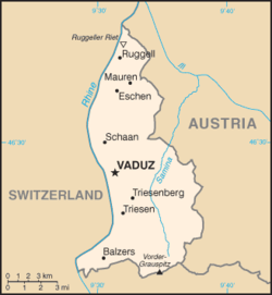
The principality of Liechtenstein encompasses most of the eastern half of the Rhine Valley, wedged between Austria and Switzerland. The majority of the country's population is found in the western half along the Rhine River. [1] Along with Uzbekistan, Liechtenstein is one of only two doubly landlocked countries in the world.

Contents

Statistics

Geographic coordinates: 47°10′N9°32′E / 47.167°N 9.533°E / 47.167; 9.533 (Liechtenstein)

Area: 160 km2 (land, 0 km2 water)

Land boundaries

total: 76 km
border countries: Austria 35 km, Switzerland 41 km

Lake

The only lake in Liechtenstein is the Gampriner Seele.

Land use

arable land: 21.88%
permanent crops: 0%
other: 78.12% (2011)

Terrain

Mostly mountainous (Alps) with Rhine Valley in western third

Natural resources:

Hydroelectric potential, arable land

Extreme points:

Climate

Continental; cold, cloudy winters with frequent snow or rain; cool to moderately warm, cloudy, humid summers, great variety of microclimates based on elevation.

Environment - international agreements

Party to:

Air Pollution, Air Pollution-Persistent Organic Pollutants, Air Pollution-Nitrogen Oxides, Air Pollution-Sulphur 85, Air Pollution-Sulphur 94, Air Pollution-Volatile Organic Compounds, Biodiversity, Climate Change, Climate Change-Kyoto Protocol, Desertification, Endangered Species, Hazardous Wastes, Ozone Layer Protection, Wetlands,

Signed, but not ratified:

Law of the Sea

Related Research Articles

<span class="mw-page-title-main">Geography of Brunei</span>

Brunei is a country in Southeast Asia, bordering the South China Sea and East Malaysia. Its geographical coordinates are 4°30′N114°40′E. The country is small with a total size of 5,765 km2 (2,226 sq mi). It is larger in size than Trinidad and Tobago. It is close to vital sea lanes through the South China Sea linking the Indian and Pacific Oceans. The country has two parts physically separated by Malaysia, making it almost an enclave within Malaysia.

<span class="mw-page-title-main">Geography of Denmark</span>

Denmark is a Nordic country located in Northern Europe. It consists of the Jutland Peninsula and several islands in the Baltic Sea, referred to as the Danish Archipelago. Denmark is located southwest of Sweden and due south of Norway and is bordered by the German state Schleswig-Holstein to the south, with a 68 kilometres long land border.

<span class="mw-page-title-main">Geography of Estonia</span>

Between 57.3 and 59.5 latitude and 21.5 and 28.1 longitude, Estonia lies on the eastern coast of the Baltic Sea on the level northwestern part of the rising East European Platform. Estonia's continental mainland is bordered to the north by the Gulf of Finland across from Finland, to the east by Lake Peipus and Russia, and to the south by Latvia. Besides the part of the European continent, Estonian territory also includes the larger islands of Saaremaa and Hiiumaa, and over 2,200 other islands and islets in the Baltic Sea, off the western and northern shores of the country's mainland.

<span class="mw-page-title-main">Geography of Finland</span>

The geography of Finland is characterized by its northern position, its ubiquitous landscapes of intermingled boreal forests and lakes, and its low population density. Finland can be divided into three areas: archipelagoes and coastal lowlands, a slightly higher central lake plateau and uplands to north and northeast. Bordering the Baltic Sea, Gulf of Bothnia, and Gulf of Finland, as well as Sweden, Norway, and Russia, Finland is the northernmost country in the European Union. Most of the population and agricultural resources are concentrated in the south. Northern and eastern Finland are sparsely populated containing vast wilderness areas. Taiga forest is the dominant vegetation type.

<span class="mw-page-title-main">Geography of Hungary</span>

Hungary is a landlocked country in the southeastern region of Central Europe, bordering the Balkans. Situated in the Pannonian Basin, it has a land area of 93,030 square km, measuring about 250 km from north to south and 524 km from east to west. It has 2,106 km of boundaries, shared with Slovakia to the north, Ukraine to the northeast, Romania to the east and southeast, Serbia to the south, Croatia to the south and southwest, Slovenia to the west and southwest, and Austria to the west.

<span class="mw-page-title-main">Liechtenstein</span> Microstate in the Alps

Liechtenstein, officially the Principality of Liechtenstein, is a doubly landlocked German-speaking microstate located in the Alps between Austria and Switzerland. Liechtenstein is a semi-constitutional monarchy headed by the prince of Liechtenstein of the House of Liechtenstein, currently led by Hans-Adam II. Liechtenstein is bordered by Switzerland to the west and south and Austria to the east and north. It is Europe's fourth-smallest country, with an area of just over 160 square kilometres and a population of 39,790. It is the world's smallest country to border two countries.

<span class="mw-page-title-main">Geography of Lithuania</span>

Lithuania is a country in the Baltic region of Europe. The most populous of the Baltic states, Lithuania has 262 km (163 mi) of coastline consisting of the continental coast and the "Curonian Spit" coast. Lithuania's major warm-water port of Klaipėda lies at the narrow mouth of Curonian Lagoon, a shallow lagoon extending south to Kaliningrad and separated from the Baltic sea by Curonian Spit, where Kuršių Nerija National Park was established for its remarkable sand dunes.

<span class="mw-page-title-main">Geography of Luxembourg</span>

Luxembourg is a small country located in the Low Countries, part of North-West Europe It borders Belgium for 148 kilometres to the west and north, France (73 km [45 mi]) to the south, and Germany (138 km [86 mi]) to the east. Luxembourg is landlocked, separated from the North Sea by Belgium.

<span class="mw-page-title-main">Geography of Slovakia</span>

Slovakia is a landlocked Central European country with mountainous regions in the north and flat terrain in the south. During much of the Holocene, Slovakia was much more forested than today. Decline of the forest occurred in as consequence of the Valachian colonization and the development of mining in the territory.

<span class="mw-page-title-main">Geography of Slovenia</span>

Slovenia is situated at the crossroads of central and southeast Europe, touching the Alps and bordering the Adriatic Sea. The Alps—including the Julian Alps, the Kamnik–Savinja Alps and the Karawank chain, as well as the Pohorje massif—dominate northern Slovenia along its long border to Austria. Slovenia's Adriatic coastline stretches approximately 47 km (29 mi) from Italy to Croatia. Its part south of Sava river belongs to Balkan peninsula – Balkans.

<span class="mw-page-title-main">Geography of Switzerland</span>

The geography of Switzerland features a mountainous and landlocked country located in Western and Central Europe. Switzerland's natural landscape is marked by its numerous lakes and mountains. It is surrounded by five countries: Austria and Liechtenstein to the east, France to the west, Italy to the south and Germany to the north. Switzerland has a maximum north–south length of 220 kilometres (140 mi) and an east–west length of about 350 kilometres (220 mi).

<span class="mw-page-title-main">Geography of Togo</span>

Togo is a small Sub-Saharan state, comprising a long strip of land in West Africa. Togo's geographic coordinates are a latitude of 8° north and a longitude of 1°10′ east. It is bordered by three countries: Benin to the east, with 644 km (400 mi) of border; Burkina Faso to the north, with 126 km (78 mi) of border; and Ghana, with 877 km (545 mi) of border. To the south Togo has 56 km (35 mi) of coastline along the Bight of Benin of the Gulf of Guinea in the North Atlantic Ocean. Togo stretches 579 km (360 mi) north from the Gulf and is only 160 km (99 mi) wide at the broadest point. In total, Togo has an area of 56,785 km2 (21,925 sq mi), of which 54,385 km2 (20,998 sq mi) is land and 2,400 km2 (927 sq mi) is water.

<span class="mw-page-title-main">Geography of Uzbekistan</span>

Uzbekistan is a country in Central Asia, located north of Turkmenistan and Afghanistan. With an area of approximately 447,000 square kilometers, Uzbekistan stretches 1,425 km (885 mi) from west to east and 930 km (580 mi) from north to south. It borders Turkmenistan to the southwest, Kazakhstan to the north and Tajikistan and Kyrgyzstan to the south and east. Uzbekistan also has four small exclaves in Turkmenistan.

<span class="mw-page-title-main">Geography of the Netherlands</span>

The geography of the European Netherlands is unusual in that much of its land has been reclaimed from the sea and is below sea level, protected by dikes. It is a small country with a total area of 41,545 km2 (16,041 sq mi) and ranked 131st. With a population of 17.4 million and density of 521/km2 (1,350/sq mi) makes it the second most densely populated member of the European Union after Malta, and the 12th most densely populated country in the world, behind only three countries with a population over 16 million. Consequently, the Netherlands is highly urbanized.

<span class="mw-page-title-main">Geography of Iceland</span>

Iceland is an island country at the confluence of the North Atlantic and Arctic oceans, east of Greenland and immediately south of the Arctic Circle, atop the constructive boundary of the northern Mid-Atlantic Ridge. The island country is the world's 18th largest in area and one of the most sparsely populated. It is the westernmost European country when not including Greenland and has more land covered by glaciers than continental Europe. Its total size is 103,125 km2 (39,817 sq mi) and possesses an exclusive economic zone of 751,345 km2 (290,096 sq mi).

<span class="mw-page-title-main">Geography of Austria</span>

Austria is a predominantly mountainous country in Central Europe, approximately between Germany, Italy and Hungary. It has a total area of 83,871 square kilometres (32,383 sq mi).

<span class="mw-page-title-main">Eastern Alps</span> Eastern part of the Alps mountain range

The Eastern Alps are usually defined as the area east of a line from Lake Constance and the Alpine Rhine valley, up to the Splügen Pass at the Alpine divide, and down the Liro River to Lake Como in the south. The peaks and mountain passes are lower than the Western Alps, while the range itself is broader and less arched.

<span class="mw-page-title-main">Eschnerberg</span>

Eschnerberg, also Eschner Berg,Schellenberg, is 698 m high mountain of seven peaks in the Rhine Valley, on the borderline of Liechtenstein and the Austrian State Voralberg, close to Feldkirch.

<span class="mw-page-title-main">Geography of Germany</span>

Germany is a country in Central and Western Europe that stretches from the Alps, across the North European Plain to the North Sea and the Baltic Sea. It is the second-most populous country in Europe after Russia, and is seventh-largest country by area in the continent. The area of Germany ranked 63rd and covers 357,021 km2 (137,847 sq mi), consisting of 349,223 km2 (134,836 sq mi) of land and 7,798 km2 (3,011 sq mi) of waters, smaller than Japan but larger than Republic of the Congo.

<span class="mw-page-title-main">Liechtenstein inland canal</span> Artificial water stream in Liechtenstein

The inland canal in Liechtenstein is a 23km long artificial stream of water created between 1931 and 1943. The canal flows into the Rhine and receives water from twelve Alpine streams. It is considered one of the most significant constructions in the country.

References

  1. "The World Factbook — Central Intelligence Agency". www.cia.gov. Retrieved 2018-09-17.

PD-icon.svg This article incorporates public domain material from The World Factbook. CIA.