Geography of Greece

Last updated

Geography of Greece
Greece topo.jpg
Continent Europe
Region South Europe
Coordinates 39°00′N22°00′E / 39.000°N 22.000°E / 39.000; 22.000
Area Ranked 95th
  Total131,957 km2 (50,949 sq mi)
  Land99.13%
  Water0.87%
Coastline13,676 km (8,498 mi)
Borders689.76
Highest point Mount Olympus
2,918 metres (9,573 ft)
Lowest point Mediterranean Sea
0 m
Longest river Haliacmon
297 kilometres (185 mi)
Largest lake Lake Trichonida
98.6 km2 (38.07 sq mi)
Exclusive economic zone505,572 km2 (195,202 sq mi)

Greece is a country in Southeastern Europe, on the Balkan Peninsula. [1] It is bordered to the north by Albania, North Macedonia and Bulgaria; to the east by Turkey, and is surrounded to the east by the Aegean Sea, to the south by the Cretan and the Libyan seas, and to the west by the Ionian Sea which separates Greece from Italy.

Contents

The country consists of a mountainous, peninsular mainland jutting out into the Mediterranean Sea at the southernmost tip of the Balkans, and two smaller peninsulas projecting from it: the Chalkidiki and the Peloponnese, which is joined to the mainland by the Isthmus of Corinth. Greece also has many islands, of various sizes, the largest being Crete, Euboea, Lesvos, Rhodes, Chios, Kefalonia, and Corfu; groups of smaller islands include the Dodecanese and the Cyclades. According to the CIA World Factbook , Greece has 13,676 kilometres (8,498 mi) of coastline, the largest in the Mediterranean Basin. [2]

Greece's latitude ranges from 35°N to 42°N and its longitude from 19°E to 28°E. As a result of this and its physical geography, the country has considerable climatic variation.

Physical geography

Greece in August 2004, MODIS Terra satellite image Greece MODIS Terra Satellite Image 19 Aug 2004.jpg
Greece in August 2004, MODIS Terra satellite image

Greece is located in South Eastern Europe, bordering the Ionian Sea and the Mediterranean Sea. It is a peninsular country, with an archipelago of about 3,000 islands.

It has a total area of 131,957 km2 (50,949 sq mi), [3] of which land area is 130,647 km2 and internal waters (lakes and rivers) account for 1,310 km2. Land boundaries with Albania (212 km), North Macedonia (234 km), Bulgaria (472 km) and Turkey (192 km) measure approximately 1,110 km in total. Of the country's total territory, 83.33% or 110,496 km2 (42,663 sq mi) is mainland territory and the rest 16.67% or 21,461 km2 (8,286 sq mi) is island territory. [4] It has an exclusive economic zone of 505,572 km2 (195,202 sq mi).

Greece's coastline measures 13,676 km (8,498 mi).[ citation needed ]

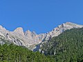
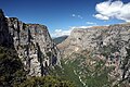
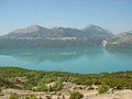
80% of Greece is mountainous. The Pindus mountain range lies across the center of the country in a northwest-to-southeast direction, with a maximum elevation of 2,637 m. Extensions of the same mountain range stretch across the Peloponnese and underwater across the Aegean, forming many of the Aegean Islands including Crete, and joining with the Taurus Mountains of southern Turkey. Central and western Greece contain high and steep peaks intersected by many canyons and other karstic landscapes, including the Meteora and the Vikos Gorges – the latter being the world's deepest canyon in proportion to its width, and the third deepest after the Copper Canyon in Mexico and the Grand Canyon in the United States, plunging vertically for more than 1,100 metres. [5]

Mount Olympus is the highest point in Greece, the 7th highest and the 9th most prominent mountain in mainland Europe (together with Gerlachovský štít and including Großglockner as a separate mountain), [6] rising to 2,917 m above sea level. The Rhodope Mountains form the border between Greece and Bulgaria; that area is covered with vast and thick forests.

Greece's lowest point is sea level. [7]

Plains are found in eastern Thessaly, in central Macedonia and in Thrace.

Extremities of Greece

The extreme points of Greece are [8]

Regions of Greece
Cities and islands of Greece
Greece's cities, main towns, main rivers, islands and selected archaeological sites. GreeceOMC.png
Greece's cities, main towns, main rivers, islands and selected archaeological sites.

Mainland

Mainland Greece forms the southernmost part of the Balkan peninsula with two additional smaller peninsulas projecting from it: the Chalkidiki and the Peloponnese. The north of the country includes the regions of Macedonia and Thrace. To the south the mainland narrows and includes the regions of Epirus, Thessaly and Central Greece, where the region of Attica and the capital city Athens are located. Further south, the smaller peninsula of Peloponnese is separated from the rest of the Greek mainland by the Corinthian and Saronic Gulfs, but joined by the Isthmus of Corinth.

Mainland Greece covers about 80% of the total territory and is largely mountainous. The largest mountain range of Greece is the Pindus range, the southern extension of the Dinaric Alps, which forms the spine of the Greek mainland, separating Epirus from Thessaly and Macedonia. The country's tallest mountain is Mount Olympus, which also separates Thessaly from Macedonia. Its highest peak rises to 2,918 m above sea level, making it the second highest of the Balkan peninsula after Musala in the Rila Mountain.

The number of islands vary between 1,200 and 6,000. [9] A figure frequently cited in travel guides is 1,425 islands, of which 166 are said to be inhabited. [10] The Greek Tourism Organization reports a figure of 6,000, with 227 of them inhabited. [11] Paris Match, however, raises this number to 9,841 islands, of which only 169 have a recorded continuous human presence. [12]

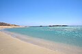
The Greek islands account for about 20% of the country's total territory, [13] and vary greatly in size as well as in climate. The country's largest island is Crete, with Euboea being second largest. Other large Greek islands include Rhodes and Lesbos in the Aegean Sea, and Corfu and Cephalonia in the Ionian Sea. Many of the smaller Greek islands form groups or chains, often called archipelagos, with notable examples being the Cyclades and the Sporades in the south and central Aegean Sea respectively.

Aegean

The islands of the Aegean Sea are situated between mainland Greece to the west and north, Anatolia to the east and the island of Crete to the south. Traditionally, the islands are classified into seven groups, from north to south:

Ionian Islands

The Ionian Islands are a group of seven islands. The six northern islands lie off the western coast of Greece, in the Ionian Sea. The other island, Kythira, lies off the southern tip of the Peloponnese. Kythira is part of the modern administrative region of Attica, not the Ionian Islands (Ionioi Nisoi). The Ionian Islands are distinct from the historical region of Ionia, which is today part of western Turkey.

Crete

NASA photograph of Crete Island of Crete, Greece.JPG
NASA photograph of Crete

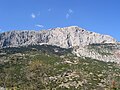
Crete is the largest island of Greece and the second largest in the Eastern Mediterranean, after Cyprus. The island spans 260 km from east to west and 60 km from north to south at its widest. The island narrows in the region close to Ierapetra, where it is only 12 km wide. Crete covers an area of 8,336 km2 (3,219 sq mi), with a coastline of 1046 km. It is surrounded to the north by the Sea of Crete; to the south by the Libyan Sea; to the west by the Myrtoan Sea; and to the east by the Karpathion Sea. It lies about 160 km south of the Greek mainland.

Crete is characterized by a mountain range crossing from west to east, formed by three different subranges:

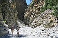
These encompass fertile plateaus, such as Lasithi, Omalos and Nidha; caves such as Diktaion and Idaion; and gorges such as the Samariá Gorge. The protected area of the Samariá Gorge is the home of the Cretan goat, or kri-kri, while the endangered Bearded vulture or lammergeyer lives in the Cretan mountains and gorges.

Crete's rivers include the Ieropotamos River in the southern part of the island.

Land use

Irrigated land: 15,550 km2 (2007)

Environment

Map of earthquakes in Greece and adjacent countries 1900-2017 Map of earthquakes in Greece 1900-2017.svg
Map of earthquakes in Greece and adjacent countries 1900–2017

Greece is a mostly mountainous country with a very long coastline, filled with peninsulas and islands.

The climate can range from semi-desert to cold climate mountain forests.

Greece's natural hazards include severe earthquakes, floods, droughts and wildfires. Current environmental issues in Greece include air pollution and water pollution.

See also

Related Research Articles

<span class="mw-page-title-main">Aegean Sea</span> Part of the Mediterranean between Greece and Turkey

The Aegean Sea is an elongated embayment of the Mediterranean Sea between Europe and Asia. It is located between the Balkans and Anatolia, and covers an area of some 215,000 km2 (83,000 sq mi). In the north, the Aegean is connected to the Marmara Sea, which in turn connects to the Black Sea, by the straits of the Dardanelles and the Bosphorus, respectively. The Aegean Islands are located within the sea and some bound it on its southern periphery, including Crete and Rhodes. The sea reaches a maximum depth of 2,639 m (8,658 ft) to the west of Karpathos. The Thracian Sea and the Sea of Crete are main subdivisions of the Aegean Sea.

<span class="mw-page-title-main">Crete</span> Largest Greek island

Crete is the largest and most populous of the Greek islands, the 88th largest island in the world and the fifth largest island in the Mediterranean Sea, after Sicily, Sardinia, Cyprus, and Corsica. Crete rests about 160 km (99 mi) south of the Greek mainland, and about 100 km (62 mi) southwest of Anatolia. Crete has an area of 8,450 km2 (3,260 sq mi) and a coastline of 1,046 km (650 mi). It bounds the southern border of the Aegean Sea, with the Sea of Crete to the north and the Libyan Sea to the south. Crete covers 260 km from west to east but is narrow from north to south, spanning three longitudes but only half a latitude.

<span class="mw-page-title-main">Tourism in Greece</span> Tourism regarding Greece

Tourism in Greece has been a key element of the economic activity in the country, and is one of the country's most important sectors. Greece has been a major tourist destination and attraction in Europe since the 1970s for its rich culture and history, which is reflected in large part by its 18 UNESCO World Heritage Sites, among the most in Europe and the world as well as for its long coastline, many islands, and beaches.

<span class="mw-page-title-main">Sporades</span> Regional unit in Thessaly Central Greece, Greece

The (Northern) Sporades are an archipelago along the east coast of Greece, northeast of the island of Euboea, in the Aegean Sea. They consist of 24 islands, four of which are permanently inhabited: Alonnisos, Skiathos, Skopelos and Skyros. They may also be referred to as the Thessalian Sporades.

<span class="mw-page-title-main">Aegean Islands</span> Group of islands

The Aegean Islands are the group of islands in the Aegean Sea, with mainland Greece to the west and north and Turkey to the east; the island of Crete delimits the sea to the south, those of Rhodes, Karpathos and Kasos to the southeast. The ancient Greek name of the Aegean Sea, Archipelago, was later applied to the islands it contains and is now used more generally, to refer to any island group.

<span class="mw-page-title-main">Central Greece</span> Central part of Greece

Continental Greece, colloquially known as Roúmeli (Ρούμελη), is a traditional geographic region of Greece. In English, the area is usually called Central Greece, but the equivalent Greek term is more rarely used.

<span class="mw-page-title-main">Byzantine Greece</span> Historical period of Greece

Byzantine Greece has a history that mainly coincides with that of the Byzantine Empire itself.

<span class="mw-page-title-main">Geography of Europe</span>

Europe is traditionally defined as one of seven continents. Physiographically, it is the northwestern peninsula of the larger landmass known as Eurasia ; Asia occupies the centre and east of this continuous landmass. Europe's eastern frontier is usually delineated by the Ural Mountains in Russia, which is the largest country by land area in the continent. The southeast boundary with Asia is not universally defined, but the modern definition is generally the Ural River or, less commonly, the Emba River. The boundary continues to the Caspian Sea, the crest of the Caucasus Mountains, and on to the Black Sea. The Bosporus, the Sea of Marmara, and the Dardanelles conclude the Asian boundary. The Mediterranean Sea to the south separates Europe from Africa. The western boundary is the Atlantic Ocean. Iceland is usually included in Europe because it is over twice as close to mainland Europe as mainland North America. There is ongoing debate on where the geographical centre of Europe falls.

<span class="mw-page-title-main">Sea of Crete</span> Aegean Sea southern portion

The Sea of Crete, or Cretan Sea, is a sea, part of the Aegean Sea, located in its southern extremity, with a total surface area of 45,000 km2 (17,000 sq mi). The sea stretches to the north of the island of Crete, east of the islands of Kythera and Antikythera, south of the Cyclades, and west of the Dodecanese islands of Rhodes, Karpathos and Kassos. The bounding sea to the west is the Ionian Sea. To the northwest is the Myrtoan Sea, a subdivision of the Mediterranean Sea that lies between the Cyclades and Peloponnese. To the east-southeast is the rest of the Mediterranean Sea, sometimes credited as the Levantine Sea. Across the island of Crete, to the opposite shore of it begins the Libyan Sea. Ferry routes to and from Piraeus and Heraklion, as well as the southern islands of the Aegean and the Dodecanese, run in this area.

<span class="mw-page-title-main">Climate of Greece</span> Overview of the impacts of the climate change in Greece

The climate in Greece is predominantly Mediterranean. However, due to the country's geography, Greece has a wide range of micro-climates and local variations. The Greek mainland is extremely mountainous, making Greece one of the most mountainous countries in Europe. To the west of the Pindus mountain range, the climate is generally wetter and has some maritime features. The east of the Pindus mountain range is generally drier and windier in summer. The highest peak is Mount Olympus, 2,918 metres (9,573 ft). The northern areas of Greece have a transitional climate between the continental, the Mediterranean and the humid subtropical climate. There are mountainous areas that have an alpine climate. Also, various areas of Greece have semi-arid climates.

<span class="mw-page-title-main">Gerakini</span> Place in Greece

Yerakini or Gerakini is a village on the Chalkidiki peninsula in Central Macedonia, Northern Greece.

<span class="mw-page-title-main">Index of Greece-related articles</span>

This page list topics related to Greece.

<i>Potamon fluviatile</i> Species of crab

Potamon fluviatile is a freshwater crab found in or near wooded streams, rivers and lakes in Southern Europe. It is an omnivore with broad ecological tolerances, and adults typically reach 50 mm (2 in) in size during their 10–12 year lifespan. They inhabit burrows and are aggressive, apparently outcompeting native crayfish.

<span class="mw-page-title-main">Regions of ancient Greece</span> Geographical sub-divisions of the Hellenic world

The regions of ancient Greece were areas identified by the ancient Greeks as geographical sub-divisions of the Hellenic world. These regions are described in the works of ancient historians and geographers, and in the legends and myths of the ancient Greeks.

<span class="mw-page-title-main">Iron Age Greek migrations</span> Greek migrations (11th to 9th century BCE)

The Iron Age Greek migrations were effected by a population of émigrés from amidst the displacements and reconstruction that occurred in Greece proper from the middle of the 11th century to the end of the 9th century BCE. The movements resulted in the settlement of the Aegean islands, Cyprus, Crete and the western coast of Asia Minor and the founding of new cities, which afterwards became centers of the Greek civilization. The migrations by various tribal groups were effected in consecutive waves known as the Aeolic, Ionian, Doric and Achaean (Arcadian) migrations. The movements differed from the Greek colonisation of the Archaic period in that they were more ad hoc affairs, rather than being the result of a planned process of colonisation on the part of the mother city. They are also less well-documented historically and in folk histories are often said to have been led by a mythologized or semi-legendary leader, such as Hercules or Orestes.

The geology of Greece is highly structurally complex due to its position at the junction between the European and African tectonic plates.

<span class="mw-page-title-main">Wildlife of Greece</span>

The wildlife of Greece includes the diverse flora, fauna, and funga of Greece, a country in southern Europe. The country is mostly mountainous with a very long, convoluted coastline, consisting of peninsulas and many islands. The climate ranges from Mediterranean through temperate to alpine, and the habitats include mountains, hills, forests, rivers, lakes, coasts and cultivated land.

References

  1. "UNITED NATIONS GROUP OF EXPERTS ON GEOGRAPHICAL NAMES: Working Paper No. 48" (PDF). UN. 2006. Retrieved 2 September 2015.
  2. "The World Fact Book – Field Listing :: Coastline". CIA. Archived from the original on 13 June 2009. Retrieved 17 March 2011.
  3. National me="CIA">CIA World Fact Book,
  4. Artificial Structures and Shorelines
  5. Guinness World Records 2005: Special 50th Anniversary Edition
  6. Schmitt A(1983)Nouvelles contributions à l'étude géologique des Pieria, de l'Olympe, et de l'Ossa (Grèce du Nord)[Ph.D. dissert.]. Mons, Belgium, Faculté Polytechnique de Mons
  7. CIA. "Europe::Greece". The World Factbook. CIA. Retrieved 7 October 2016.
  8. "Statistical Yearbook of Greece 2009 & 2010" (PDF). Hellenic Statistical Authority. p. 27. Archived from the original (PDF) on 13 December 2013.
  9. Marker, Sherry; Kerasiotis, Peter (2010). "Greece in depth". In Nadeau, Mark (ed.). Frommer's Greece . Hoboken: Wiley. p.  12.
  10. Poffley, Frewin (2002). Greek Island Hopping. Thomas Cook. p. 15.
  11. Ellinikos Organismos Tourismou (EOT). "Greek islands". Archived from the original on 3 June 2012. Retrieved 29 April 2012.
  12. "Top 77256838483top=tiltli3hf83urlob39498r[e8j" . Retrieved 6 March 2017.
  13. Treves, Tullio; Pineschi, Laura (January 1997). The Law of the Sea. ISBN   9041103260.

Further reading

PD-icon.svg This article incorporates public domain material from The World Factbook. CIA.