Geography of Malta

Last updated

Geography of Malta
Malta's Landscape of Limestone.jpeg
Satellite image of Malta
Malta2021OSM.png
Continent Europe
Region Southern Europe
Coordinates 35°54′N14°31′E / 35.900°N 14.517°E / 35.900; 14.517
Area Ranked 186th
  Total316 km2 (122 sq mi)
  Land100%
  Water0%
Highest point Ta' Dmejrek
Lowest point Mediterranean Sea
Map of Malta 2.png

The geography of Malta is dominated by water. Malta is an archipelago of coralline limestone, located in Europe, in the Mediterranean Sea, 81 kilometres south of Sicily, Italy, [1] and nearly 300 km north (Libya) and northeast (Tunisia) of Africa. Although Malta is situated in Southern Europe, it is located farther south than Tunis, capital of Tunisia, Algiers, capital of Algeria, Tangier in Morocco and also Aleppo in Syria, and Mosul in Iraq in the Middle East. Only the three largest islands Malta, Gozo and Comino are inhabited. Other (uninhabited) islands are: Cominotto, Filfla and the St.Paul's Islands. The country is approximately 316 km2 (122 sq mi) in area. Numerous bays along the indented coastline of the islands provide harbours. The landscape of the islands is characterised by high hills with terraced fields. The highest point, at 253 metres, Ta' Zuta on mainland Malta. The capital is Valletta.

Contents

Statistics

Malta has a total area of 315.718 km2, [2] with land making up 315.718 km2 and water taking up zero area. Compared to other political entities, this makes Malta:

Excluding 56 km from the island of Gozo, Malta has a coastline of 196.8 km. Its maritime claims of territorial sea are 12 nmi (22.2 km; 13.8 mi), contiguous zone is 24  nmi (44.4 km; 27.6 mi), continental shelf is 200 m depth or to the depth of exploitation, and Malta's exclusive fishing zone spans 25 nmi (46.3 km; 28.8 mi).

Islands

NameAreaNote/
coordinates
Image
Malta Island 246 km² [2] 35°52′55″N14°26′57″E / 35.88182°N 14.44908°E / 35.88182; 14.44908 (Malta) [3] Malta ali 2009224 lrg.jpg
Gozo
(Għawdex)
67.1 km² [2] 36°02′58″N14°15′00″E / 36.04944°N 14.25°E / 36.04944; 14.25 (Gozo) [3] Gozo from space via laser ESA378503.jpg
Comino
(Kemmuna)
2.8 km² [2] 36°00′44″N14°20′12″E / 36.01226°N 14.33669°E / 36.01226; 14.33669 (Comino) [3] Sudika Kemmuna.jpg
Manoel Island
(Il-Gżira Manoel)
0.3 km² 35°54′14″N14°30′07″E / 35.904°N 14.502°E / 35.904; 14.502 (Manoel Island) Aerial view of Manoel Island.jpg
St Paul's Islands
(Il-Gżejjer ta' San Pawl)
0.101 km² [2] 35°57′55″N14°24′2″E / 35.96528°N 14.40056°E / 35.96528; 14.40056 (St Paul's Island) Selmunett Island.jpg
Cominotto
(Kemmunett)
0.099 km² [4] 36°00′49″N14°19′10″E / 36.01361°N 14.31944°E / 36.01361; 14.31944 (Kemmunett) [3] Malta - Ghajnsielem - Cominotto + Blue Lagoon (Comino) 03 ies.jpg
Filfla (and Filfoletta)0.020 km² [2] 35°47′15″N14°24′37″E / 35.78750°N 14.41028°E / 35.78750; 14.41028 (Filfla) Filfla 1.jpg
Fungus Rock
(Il-Ġebla tal-Ġeneral)
0.007 km² [2] 36°02′49″N14°11′20″E / 36.04694°N 14.18889°E / 36.04694; 14.18889 (Fungus Rock) [3] Fungus rock.JPG
Ħalfa Rock
(Il-Ġebla tal-Ħalfa)
0.0050 km² [5] [6] 36°01′45″N14°19′51″E / 36.02917°N 14.33083°E / 36.02917; 14.33083 (Ġebel tal-Ħalfa) [3] Situated near Gozo. In the island there is 4 to 5 metres deep water rock pool just 2 metres above sea level, possibly man made due to its perfectly round shape. There is also an underground fresh water system which emerges from a small cave. Most of the plants occurs on the western part of the island. Crucianella rupestris, Anthrocnemum macrostachyum, Lygeum spartum, Convolvulus oleifolius, Thymbra capitata, Teucrium fruticans, Allium melitense, Anacamptis urvilleana, Bromus madritensis, Capparis spinosa, Echium parviflorum, Pallenis spinosa, Plantago lagopus, Trachynia distachya, Urginea pancration. [4] Gebla tal Halfa1.jpg
Old Battery's Rock
(Ġebla ta' taħt il-Batterija)
Situated on the southeast of Comino. Flora consisted of 22 individuals of Inula crithmoides (2010). [4]
Lantern Point Rock
(Ġebla Tal-Ponta Rqiqa)
Situated near Comino. [4] Live here two species of plants: Limonium melitense and Inula crithmoides. It has a height of 7 meters. [7] Malta - Ghajnsielem - Lantern Point Rock (Comino) 01 ies.jpg
Large Blue Lagoon Rock In island, there is a cave. Species of plants: Hypericium aegypticum, Daucus carota, Convolvulus oleifolius, Darniella melitensis, Arthrocnemum macrostachyum, Senecio bicolor. [4] View-Gozo-DSC 0156.jpg
Small Blue Lagoon Rocks Situated between Large Blue Lagoon and Cominotto. Species of plants: Arthrocnemum macrostachyum, Daucus carota, Lygeum spartum, Lavatera arborea. [4] Malta - Ghajnsielem - Small Blue Lagoon Rock (Comino) 01 ies.jpg
Devil's End Rock
(Il-Ġebla tax-Xifer l-Infern) [4]
Situated near main island, Delimara point. Delimara Point Nov 2014 03.JPG
Għallis Rocks [4] 35°57′13″N14°26′46″E / 35.95361°N 14.44611°E / 35.95361; 14.44611 (Għallis Rocks) [3] Malta - Naxxar - Ghallis Rocks 01 ies.jpg
Taċ-Ċawl Rock
(Il-Ġebla taċ-Ċawl)
36°01′34″N14°18′57″E / 36.02611°N 14.31583°E / 36.02611; 14.31583 (Il-Ġebel taċ-Ċawl) [3] Situated near Gozo. The flora consisted of Lygeum spartum, Asphodelus aestivus, Crithmum maritimum, Cichorium spinosum, Crucianella rupestrisis, Opuntia, Thymbra capitata, Euphorbia melitensis, Foeniculum vulgare, Allium commutatum, Allium lajoconoi, Bromus madritensis, Capparis spinosa, Gynandriris sisirynchium, Pistacia lentiscus, Phagnalon graceum, Sedum litoreum, Sonchus tenerrimus, Trachynia distachya, Valantia muralis. [4]
Cheirolophus Rock
(Ħaġra tas-Sajjetta)
Situated near main island. It has a height of 9 to 12 meters high at its highest point. Species of plants: Darniella melitensis, Crithmum maritimum, Cheirolophus crassifolius, Inula crithmoides, Limonium virgatum, Daucus carota, Cheirolophus crassifolius. [4]
Barbaganni RockSituated near Gozo. No soil exists on the islet because island is inundated by water wave action during rough weather. The flora consisted of only 14 individuals of Inula crithmoides (2010). [4]
Crocodile Rock & Bear rocks
(Il-Ġebla tal-Baqra u il-Ġebel tal-Orsijiet)
Near Gozo, three rocks in total. [4]
Qawra Point
(Ta' Fra Ben islet, Il-Ponta jew Ras il- Qawra)
Situated near main island. The western part is littered with small boulders, while much of the vegetation occurs in the middle part of the islet. In island there is sea cave occurs as a big hole in the middle of the islet. Species of plants: Arthrocnemum macrostachyum, Anthemis urvilleana, Inula crithmoides, Lotus cystisoides, Limonium, Sporbolus pungens. [4] Malta - St. Paul's Bay - Triq it-Trunciera - Ras il-Qawra + peninsula 02 ies.jpg
Comino Cliff Face Rock
(Ta' Taħt il-Mazz Rock)
Situated near Comino. The island is very steep - cliffs. The majority of species of plants occur on its west side, while only one species of plant inhabits its east side. Species of plants: Matthiola incana, Inula crithmoides, Darniella melitensis, Daucus carota, Limonium melitensis, Anthyllis hermanniae, Pistacia lentiscus. [4]
Xrobb l-Għaġin Rock
(It-Taqtiegħa) [4]
Fessej Rock
(Il-Ġebla tal-Fessej) [4] [8]
Islet as viewed by the Mgarr ix-Xini Tower.jpeg
Għemieri Rocks
(L-iskolli tal-Għemieri) [4]
Ħnejja Rocks
(Ġebel tal-Ħnejja) [4]
White Rock / Blue Islets (Rocks)
(Ġebla tal-Għar Qawqla) [4]
36°04′27″N14°15′45″E / 36.07417°N 14.26250°E / 36.07417; 14.26250 (Għar Qawqla) Marsalforn Rock Formation.jpg

Climate

Mediterranean with mild, rainy winters and hot, dry summers.

Elevation extremes

The lowest point is the Mediterranean Sea at 0 m and the highest point is Ta' Dmejrek at 253 m.

Land use

Irrigated land

32 km2 (2007)

Total renewable water resources

A fresh-water spring, Ghajn Bierda, at Ras ir-Raheb Ghajn Bierda (12524091145).jpg
A fresh-water spring, Għajn Bierda, at Ras ir-Raħeb

0.05 km3 (2011)

Environment

Current issues

Limited natural fresh water resources; increasing reliance on desalination.

International Agreements

signed, but not ratified:

Related Research Articles

<span class="mw-page-title-main">Geography of the Federated States of Micronesia</span>

Geography of the Federated States of Micronesia (FSM), a country located in the western Pacific Ocean, and in the Micronesia cultural and ecological sub-region of Oceania. While its total land area is very small at 702 km2 (271 sq mi), it has the 14th largest exclusive economic zone at 2,996,419 km2 (1,156,924 sq mi).

<span class="mw-page-title-main">Geography of Italy</span> Geographical features of Italy

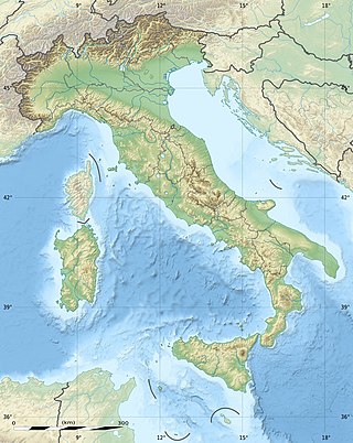
The geography of Italy includes the description of all the physical geographical elements of Italy. Italy, whose territory largely coincides with the homonymous geographical region, is located in southern Europe and comprises the long, boot-shaped Italian Peninsula crossed by the Apennines, the southern side of Alps, the large plain of the Po Valley and some islands including Sicily and Sardinia. Italy is part of the Northern Hemisphere. Two of the Pelagie Islands are located on the African continent.

<span class="mw-page-title-main">Malta (island)</span> Largest island of the Maltese Archipelago

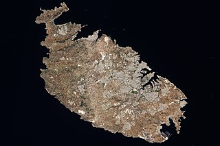
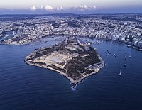
Malta is an island in Southern Europe. It is the largest and most populous of the three major islands that constitute the Maltese Archipelago. The island is situated in the Mediterranean Sea, directly south of Italy and north of Libya. Lying to the south-east of the smaller islands of Gozo and Comino, it is sometimes referred to as Valletta for statistical purposes to distinguish the main island from the entire country. The island is 27 kilometres (17 mi) long and 14.5 kilometres (9 mi) wide, with a total area of 246 square kilometres (95 sq mi). The capital is Valletta, while the largest locality is Rabat. The island is made up of many small towns, which together form one larger urban zone with a population of 409,259. The landscape is characterised by low hills with terraced fields.

<span class="mw-page-title-main">Filfla</span> Uninhabited island in Malta

Filfla is a mostly barren, uninhabited islet 4.5 kilometres south of Malta, and is the most southerly point of the Maltese Archipelago. Filflu, a rocky islet some 101 metres southwest of Filfla, has the southernmost point of Malta. The name is believed to come from felfel, the Arabic for a peppercorn.

<span class="mw-page-title-main">Comino</span> Maltese island

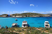
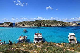
Comino is a small island of the Maltese archipelago between the islands of Malta and Gozo in the Mediterranean Sea, measuring 3.5 square kilometres (1.4 sq mi) in area. Named after the cumin seed, the island has a permanent population of only two residents and is part of the municipality of Għajnsielem, in southeastern Gozo, from where one priest and one policeman commute. The island is a bird sanctuary and nature reserve.

<span class="mw-page-title-main">Fungus Rock</span> Small islet in Gozo, Malta

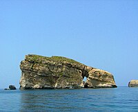
Fungus Rock, sometimes known as Mushroom Rock, and among the Maltese as Il-Ġebla tal-Ġeneral, is a small islet in the form of a 60-metre-high (200 ft) massive lump of limestone at the entrance to an almost circular black lagoon in Dwejra, on the coast of Gozo, itself an island in the Maltese archipelago. It is located at 36°02′45″N14°11′27″E and falls within the jurisdiction of the town of San Lawrenz.

<span class="mw-page-title-main">Cominotto</span> Small island off Malta

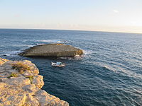
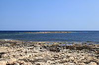
Cominotto, sometimes referred to as Cominetto, is an uninhabited Mediterranean island off the northern coast of Malta. It is located near the larger island of Comino and is part of the Maltese archipelago. Measuring at only 0.25 square kilometres (0.10 sq mi) in area, it is the largest uninhabited island of Malta. Cominotto lies 100 metres to the north-west of Comino.

<span class="mw-page-title-main">Qala, Malta</span> Local council in Gozo Region, Malta

Qala is an administrative unit of Malta, on the island of Gozo, with a population of 1,929 as of September 2019. Nearby is Ħondoq ir-Rummien, a coastline with salt pans and caves.

<span class="mw-page-title-main">Roman Catholic Diocese of Gozo</span> Diocese of the Catholic Church

The Diocese of Gozo is a Latin diocese of the Catholic Church in Malta, and the only suffragan in the ecclesiastical province of the Metropolitan Archdiocese of Malta, together covering the insular state.

<span class="mw-page-title-main">Districts of Malta</span>

Malta is for non-local government purposes divided into districts as opposed to the local government localities. The three main types of such districts – statistical, electoral at national level, and policing – have no mainstream administrative effect as the local councils form the first-tier – moreover only administrative tier – divisions of the country.

<span class="mw-page-title-main">Filfola lizard</span> Species of lizard

The filfola lizard or Maltese wall lizard is a species of lizard in the family Lacertidae. It is found in Italy and in the island group of Malta. Its natural habitats are Mediterranean-type shrubby vegetation, rocky areas, rocky shores, arable land, pastureland, and rural gardens.

<span class="mw-page-title-main">Outline of Malta</span> Overview of and topical guide to Malta

The following outline is provided as an overview of and topical guide to Malta:

<span class="mw-page-title-main">Gozo Region</span> Region of Malta in Gozo and Comino

Gozo Region is one of five regions of Malta. The region includes the islands of Gozo, Comino and several little islets such as Cominotto. The region does not border with any other regions, but it is close to the Northern Region.

The Malta–Gozo Channel Important Bird Area lies in the Maltese archipelago of the Mediterranean Sea. It encompasses some 123 km2 of the Gozo Channel, between the islands of Malta and Gozo, as well as the waters up to 7 km offshore from Rdum Tal-Madonna in Malta to the east and immediately offshore from Ta' Ċenċ Cliffs in Gozo to the west. It was identified as an Important Bird Area (IBA) by BirdLife International because it supports about 1300 breeding pairs of Cory's shearwaters and 600–1000 pairs of yelkouan shearwaters, as well as up to 1000 ferruginous ducks on passage during the migration season.

<span class="mw-page-title-main">Ħalfa Rock</span> Deserted small islet and limestone rock in the Maltese archipelago

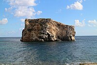
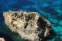
Ħalfa Rock(Maltese: Il-Ġebla tal-Ħalfaor Il-Blata tal-Ħalfa) is a deserted small islet and limestone rock on the south-east coast of the island of Gozo in the Maltese archipelago. The small islet is typified by a small maritime labiate garrigue environment, with germander and prasium shrubs, with the occurrence of the endemic Maltese Pyramidal Orchid as well as endemic coastal communities based on the Maltese Sea-Lavender and the sub-endemic Maltese Crosswort.

<span class="mw-page-title-main">Geology of Malta</span>

The Geology of Malta consists of a sequence of sedimentary rocks of late Oligocene to late Miocene age cut through by a set of extensional faults of Pliocene age.

<span class="mw-page-title-main">Geography of Gozo</span> Geography of Gozo, Malta

The geographyof Gozo, is dominated by water as it is the second largest island in the Maltese archipelago and is made up out of limestone. There are several islands which fall under Gozitan jurisdiction and thus are additions to the overarching Maltese archipelago. The main island of Gozo is located 7 kilometres (4.3 mi) northwest of the main island of Malta. It is mostly known for its multitude of low-lying hills. The highest point in Gozo is Ta' Dbiegi hill, which falls under the San Lawrenz local council. The island of Comino, which is also the third largest island in Malta, falls under Gozo.

References

  1. From Żebbuġ in Malta, coordinates: 36°04'48.2"N 14°15'06.7"E to Cava d'Aliga (Scicli) in Italy, coordinates: 36°43'22.5"N 14°41'10.9"E – Google Maps
  2. 1 2 3 4 5 6 7 State of the Environment Report for Malta 1998 Archived 2015-04-02 at the Wayback Machine
  3. 1 2 3 4 5 6 7 8 "Islands of Malta". GeoNames . Retrieved October 26, 2021.
  4. 1 2 3 4 5 6 7 8 9 10 11 12 13 14 15 16 17 18 19 "Topography and Flora of the Satellite islets surrounding the Maltese Archipelago" - Arnold Sciberras, Jeffrey Sciberras, 2010
  5. Il-Gebla tal-Halfa - Malta Environment & Planning Authority (MEPA)
  6. Site factsheet for Il-Gebla tal-Halfa - EUNIS
  7. "A contribution to the knowledge of the terrestrial Mammalian fauna of Comino and its satellite islets (Maltese Archipelago)" - Biodiversity Journal, 2012, 3 (3): 191-200
  8. Caruana, Joseph (2011). "Toponomi t'Għajnsielem (1)" (PDF). L-Imnara. Rivista tal-Għaqda Maltija tal-Folklor. 9 (4): 189. Archived from the original (PDF) on 18 April 2016.